BlockBefore
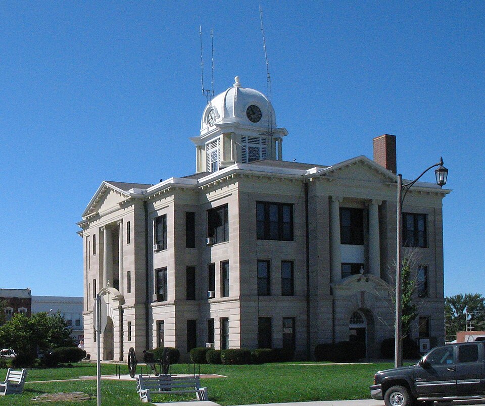
Photograph of Daviess County Courthouse
Photograph by en:User:Americasroof, CC BY-SA 3.0. Via Wikimedia Commons.

Daviess County Courthouse

Listed on the National Register of Historic Places in 1980.

From the record

“Daviess County Courthouse is a historic courthouse located at Gallatin, Daviess County, Missouri. It is a three-story, Renaissance Revival style, cross-plan building of smooth stone.”

Wikipedia article Daviess County Courthouse (Missouri), CC BY-SA 4.0.

One of 3 National Register listings published here for Daviess County · listed in 1980 · category: Building.

Sources: the Wikipedia article · the case file at the National Archives · the National Register database, National Park Service

The listing

  • What is counted as historic. The nomination lists 1 building as contributing to the listing.
  • Address. Public Sq., Gallatin, 64640
  • When was it listed? November 1980
  • Category. building
  • Township. Union township
  • Architect. P.H. Weathers
  • National Register reference number. 80002350 - the number the National Park Service assigned this property when it was listed, and the key its nomination file is catalogued under at the National Archives.

What happened here

An account from the chapter on Union township. The inset identifies its exact source book and publication year.

From The History Of Daviess County, Missouri (Birdsall & Dean, 1882), published 1882 - Union Township

Murder Of Joun W, Sheets

One of the most dread events in the history of Gallatin, and Daviess county, was the cold blooded murder of John W. Sheets, cashier of the Daviess County Saving Association. The killing occurred December 7, 1869, and sent a thrill of horror through the hearts of the people. Mr. Sheets was one of the old settlers of the county, stood high as an honorable man and citizen, and had, in numerous instances, served the people faithfully and well in an official capacity.

Read the rest of this passage

The ground it stands on

54,761 words

The chapter on Union Township in The History Of Daviess County, Missouri (Birdsall & Dean, 1882), published 1882 names Gallatin. This is what it says, exactly as the scans read.

The surface of the township is very rolling excepting on the south and southwest. The prairies are high with an undulating surface giving them a natural drainage, and on the Grand River will be found many bold and rocky bluffs which look down upon its turbid waters from the height of from 100 to 300 feet. The banks of the Big Muddy are somewhat broken and uneven, but there are none of these prominent bluffs to be seen that gave the name to its larger neighbor and to which it is contributory. The township is nearly, if not quite, three-fourths timber, and such timber as makes the saw-mills Jangh with glee and the saws sing in joyful tones as they eut their way from end to end of the food furnished. "Oh! ves, I will board you, J will raise a dust around you, you slab-sided son of the forest," and there is plenty of that kind of work in Union township, and its wealth from its timber ean hardly be computed. There is no clearing done timber-land is cleared as fast only as wood and lumber are sold. Almost every variety of timber is found, and the soil of the township is rich, deep and mellow. Where the town of Gallatin now stands, and the hills surround. ing it, is the highest point of land in the county. Union is the southeast township of the four central townships in the county, and its northwest corner is the center of the county. It is bounded on the north by a corner of Marion, and Grand River townships, east by Jackson, south by Monroe, and west by Liberty, and has an area of 22,406.02 acres of land.

Passage source: The History Of Daviess County, Missouri (Birdsall & Dean, 1882), published 1882.

The county seat is located within its border, and it is the most populous township in the county. Just what the population of Union township was in 1860 is hard to tell. Gallatin township, of which its northeast portion was made a part of Union, had a population of 1,520 in 1860, and the other part was formed from Jackson, which had a population of 971 in 1860. Taking the northeast of one and the southwest of the other and forming Union township in 1869, the census returns of 1870 gives Union 1,515, whieh is nearly two-tifths of the population of both townships, while it had not one-fifth of the territory, for the next year, 1870. Jamesport, or rather Grant, Washington and Lincoln townships were taken from the territory of Grand River.

Passage source: The History Of Daviess County, Missouri (Birdsall & Dean, 1882), published 1882.

Machine-read from a century-old scan, so expect the errors a machine makes: misspelled names, dropped words, stray characters.

Read the whole chapter on Union Township - 54,761 words on its settlement, mills, schools and churches.

Fires near this property

20 since 1997

Regional context, not property-specific evidence. The federal wildfire occurrence database lists 20 fires within 5 miles of Daviess County Courthouse between 1997 and 2020, burning about 288 acres in total. None started naturally. None was recorded as arson. Distance is straight-line from the map coordinates, so a fire counted here may appear on a neighbouring settlement's page as well.

Reported cause Fires
Debris and open burning11
Missing data/not specified/undetermined5
Equipment and vehicle use3
Recreation and ceremony1

The most recent of them, most recent first, with the day each was reported and the service that recorded it.

DateCause SizeReported by Name on the report
19 July 2020Equipment and vehicle use2.0 acresMissouri Department of Conservation261543-03160-07192020-1555
7 April 2020Debris and open burning4.2 acresMissouri Department of Conservation261541-03160-04072020-1515
6 April 2002Debris and open burning220 acresMissouri Department of Conservationnot named
4 April 2002Debris and open burning20 acresMissouri Department of Conservationnot named
1 April 2020Missing data/not specified/undetermined1.2 acresMissouri Department of Conservation261540-03160-04012020-1955
1 April 2020Missing data/not specified/undeterminedunder an acreMissouri Department of Conservation261539-03160-04012020-1945
6 March 2020Debris and open burning20 acresMissouri Department of Conservation261535-03160-03062020-1535
31 March 2020Debris and open burningunder an acreMissouri Department of Conservation261538-03160-03312020-1715

Every fire recorded in Daviess County

Mines and quarries near this property

10 of 24 shown

Regional context, not property-specific evidence. The federal mineral resources record lists 24 workings within 5 miles of Daviess County Courthouse: 17 past producers, 5 producers, 2 unknowns. 5 still produce. What was taken out: Stone, Crushed/Broken, Sand and Gravel, Construction. Distance is straight-line from the map coordinates, so a quarry counted here may appear on a neighbouring settlement's page as well.

Where SiteCommodity StatusRecorded
Raid Quarries Plant #1 & #2Sand and Gravel, ConstructionProducer
Raid Quarries Plant #3Sand and Gravel, ConstructionProducer
UnkSand and Gravel, ConstructionPast Producer
Broskin QuarryStone, Crushed/BrokenPast Producer
F+R Limestone QuarryStone, Crushed/BrokenProducer
Gallatin QuarryStone, Crushed/BrokenProducer
Gallatin QuarryStone, Crushed/BrokenPast Producer
Gallatin Stone QuarryStone, Crushed/BrokenProducer
George QuarryStone, Crushed/BrokenPast Producer
Mcdowell QuarryStone, Crushed/BrokenPast Producer

Every working recorded in Daviess County

Storms near this property

60 of 85 shown

Regional context, not property-specific evidence. The National Weather Service names Gallatin, the town this property stands in, in 85 storm reports between 1993 and 2023: 37 thunderstorm wind, 33 hail, 10 flash flood, 3 flood. No death or injury is recorded in these reports. Each account below is quoted exactly as the forecast office filed it, from the NOAA Storm Events Database, and each date opens the federal record of that event.

WhenEvent Place namedHarm What the report says
March 2006HailGallatin$50,000no account filed
April 2010Thunderstorm WindGallatin$45,000A chimney was reported collapsed and several roofs were blown off buildings.
April 2010Thunderstorm WindGallatin$10,000A barn was blown down along Business Highway 6. A two foot diameter tree was also uprooted.
June 2009Thunderstorm WindGallatin$10,000Powerlines were reported down and an elementary school was damaged.
September 1993Thunderstorm WindGallatin$5,000Severe thunderstorms produced golfball-size hail and downed trees.
April 2010Thunderstorm WindGallatin$3,000Boats were reported to be blown over at Lake Viking.
June 1995Thunderstorm WindGallatin$1,000Severe thunderstorms moved through the area with hail and damaging winds. A telephone pole was downed east of Gallatin, and several trees and power lines were downed in and around the Jamesport area. A tree was blown down onto a porch.
May 2009Thunderstorm WindGallatin$250Large maple tree was blown down on a house.
July 2023Thunderstorm WindGallatin-Estimated 70 mph winds in Gallatin.
July 2022Thunderstorm WindGallatin-Emergency management reported power lines down near Altamont.
June 2021Flash FloodGallatin-Law enforcement reported water over several roads in Gallatin.
June 2019Flash FloodGallatin-Emergency Management reported water flowing over HWY 6.
August 2019Thunderstorm WindGallatin-A 60 mph wind was reported by the public.
July 2017Thunderstorm WindGallatin-Several trees of unknown size and condition knocked down near Gallatin.
May 2015Thunderstorm WindGallatin-Trees were blown down along Highway 6 near Highway CC, blocking the road.
June 2015Thunderstorm WindGallatin-A trained spotter reported a 60 mph wind gust.
June 2013Funnel CloudGallatin-A wall cloud and funnel cloud were observed around 5 miles south of Gallatin.
May 2013Thunderstorm WindGallatin-Thunderstorm wind gusts were estimated up to 60 mph.
June 2011Thunderstorm WindGallatin-Numerous trees reported down in Gallatin, with power out. Thunderstorm wind gusts were estimated up to 60 mph.
May 2011Thunderstorm WindGallatin-Thunderstorm wind gusts were estimated up to 60 mph.
June 2011Thunderstorm WindGallatin-Thunderstorm wind gusts were estimated up to 60 mph.
May 2011Thunderstorm WindGallatin-Thunderstorm wind gusts were estimated up to 65 mph. Small tree limbs were broken.
August 2010Thunderstorm WindGallatin-Thunderstorm wind gusts were estimated up to 60 mph.
July 2010Thunderstorm WindGallatin-Thunderstorm wind gusts were estimated up to 60 mph.
June 2010Thunderstorm WindGallatin-Thunderstorm winds were estimated up to 60 mph.
June 2010Thunderstorm WindGallatin-Thunderstorm winds were estimated up to 65 mph.
June 2009Flash FloodGallatin-Highway 13 at the intersection of Richardson Street, was impassable due to high water.
June 2009Thunderstorm WindGallatin-Thunderstorm winds were reported by a trained spotter to have gusted to 60 mph.
June 2009Thunderstorm WindGallatin-Thunderstorm winds were reported to have gusted to 70 mph.
April 2008FloodGallatin-The Grand River near Gallatin crested at 26.25 feet, or 0.25 feet above flood stage.
June 2008Flash FloodGallatin-Highway 6 was closed due to water running over the roadway.
June 2008FloodGallatin-Highway K was reported under water, just north of the intersection with Highway 6.
June 2008Flash FloodGallatin-Heavy rains caused Highway 6 to be closed 3 miles east of Gallatin. The heavy rains, also caused additional extensive flooding, to be observed on the Grand River.
June 2008Flash FloodGallatin-A significant amount of water was reported on Route 6 and Route CC, in and around Gallatin.
June 2008Flash FloodGallatin-Highway 13 was closed on the south side of Gallatin due to heavy flooding.
June 2008Flash FloodGallatin-Highway 6 was closed near the Grand River due to waist deep water.
June 2008Flash FloodGallatin-Highway 13, six miles south of Jameson, was closed due to six feet of water.
May 2007Flash FloodGallatin-Seven inches of water, reported running over the intersection of Highway 6 and County Road O.
May 2007FloodGallatin-The Grand River near Gallatin crested at 40.47 feet, or 14.47 feet above flood stage.
June 2005Tornado (F0)Gallatin-Brief tornado touchdown north of Viking Lake.
October 2004Thunderstorm WindGallatin-6 to 8 inch tree limbs down.
June 2002Thunderstorm WindGallatin-Six inch tree limbs down.
May 2000Thunderstorm WindGallatin-Law enforcement officials reported limbs up to 6 inches in diameter were downed by thunderstorm winds.
April 2000Thunderstorm WindGallatin-Law enforcement officials reported 60 mph wind gusts in Gallatin.
May 1997Thunderstorm WindGallatin-A private citizen reported a wind gust to 60 MPH during a severe thunderstorm at Gallatin.
September 1993HailGallatin-Severe thunderstorms produced golfball-size hail and downed trees.
March 2022HailGallatin-no account filed
May 2014HailGallatin-no account filed
October 2013HailGallatin-no account filed
March 2012HailGallatin-no account filed
May 2011HailGallatin-no account filed
June 2011HailGallatin-no account filed
June 2010HailGallatin-no account filed
May 2010HailGallatin-no account filed

Every storm recorded in Daviess County

Map coverage status

No historic map-sheet match is published for this property yet. That does not mean no map exists. This record needs a coordinate-quality review before it can be joined to a sheet boundary. Browse the county's mapped places while that work is pending.

Listed places nearby

2 within 8 miles

Other National Register properties close enough to walk or drive between, ordered by distance from this one. Both positions come from the same geocoding pass that matched these properties to their map sheets.

Photograph PropertyDistance Listed
Daviess County Rotary Jail and Sheriff's Residenceunder 500 feet1990
A. Ray Taylor House0.2 miles1982

Sources for this property

National Archives recordThe nomination case file for reference 80002350 in Record Group 79.
Wikipedia articleCommunity-written account of this property, licensed CC BY-SA.
Daviess CountyAll 3 listed properties in this county.

Provenance

  • Listing record. National Park Service National Register of Historic Places, listed-properties dataset, current to 2026-05-22.
  • Map join. Address geocoded through the United States Census geocoder, then tested against the published boundary of every sheet in the USGS Historical Topographic Map Collection.
  • How this page is made. Listing fields come from federal records; map-sheet coverage is a labelled coordinate-to-boundary calculation, not a source-field claim.
  • Wildfire. Short, Karen C. 2022. Spatial wildfire occurrence data for the United States, 1992-2020 [FPA_FOD_20221014]. 6th Edition. Fort Collins, CO: Forest Service Research Data Archive. https://doi.org/10.2737/RDS-2013-0009.6 Collected with United States Government funding and usable without additional permissions or fees.
  • Mines and quarries. USGS Mineral Resources Data System (MRDS) https://mrdata.usgs.gov/mrds/ A work of the United States government, no copyright under 17 U.S.C. 105.
  • Storms. NOAA National Centers for Environmental Information, Storm Events Database https://www.ncei.noaa.gov/stormevents/ A work of the United States government, no copyright under 17 U.S.C. 105. Narratives are quoted verbatim from the National Weather Service report and are not edited or summarised.