BlockBefore

Daviess County, Missouri

60 topographic sheets cover 20 settlements here, and 3 properties are on the National Register of Historic Places.

Research this county

From the record

“The only murder to record in this township was that of James Marrifield, who was stabbed by a dirk-knife in the hand of Augustus Killough, from which he died the ninth day after the eutting. The affair happened at the house of Joseph Landers, where a neighborly dance was going on. There had been some ill-feeling between the young men.”

Murder - The History Of Daviess County, Missouri (Birdsall & Dean, 1882) (1882). Machine-read text.

3 National Register listings published here · the county-history sources tell 7 stories and name 193 people · people the book names include Biographical Sketches J. W. Alexander (Union Township, 1882) · George Yp, Allen (Grand River Township, 1882) (machine-read).

Sources: the county history on the Internet Archive · the National Register database, National Park Service

Missouri within the United States
Daviess County within Missouri

What the record shows

  • 264 topographic sheet readings cover the county's settlements.
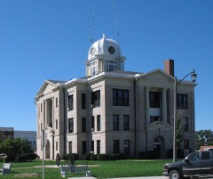
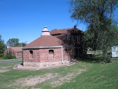
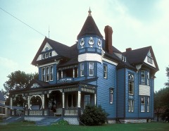
  • 3 properties here are on the National Register of Historic Places: 3 buildings.
  • The Geographic Names Information System records 20 populated places in this county; 20 are covered by at least one topographic sheet.
  • 1 public-domain county history, 1882, supplies 160,625 words of narrative reproduced here.

What happened here

7 accounts

Among them: John Oxford; Henry W. Githens; Murder Of Joun W, Sheets. These passages come from the identified county-history source books. Each inset names its own source and opens the exact section it comes from.

From The History Of Daviess County, Missouri (Birdsall & Dean, 1882), published 1882 - Jackson Township

John Oxford

The subject of this sketch was born in Clay county, Kentucky, April 9, 1833. His parents are Jonathan and Elizabeth Spurlock Oxford, the former a native of North Carolina, and the latter of Kentucky. Tis father was one of the first settlers of Daviess county, and was taken out and shot during the war, April 4, 1863; his mother still resides upon the farm where they first settled upon their arrival in this connty.

Read the rest of this passage

From The History Of Daviess County, Missouri (Birdsall & Dean, 1882), published 1882 - Salem Township

Henry W. Githens

Was born in Decatur county, Indiana, in 1823, and is the son of Samuel and Jane Githens. His father was one of the pioneers of Indiana. Mr. Githens received a limited education in the schools of his native county. He moved to Daviess county, Missouri, in 1844, where he resided eight months, when he was attacked with the "Grand River Ague," which so discouraged him that he left Missouri in disgust, returning to Indiana, where he remained five years, when he again moved to Missouri, and has lived here most of the time sinee, and owns a fine farm of 160 acres.

Read the rest of this passage

From The History Of Daviess County, Missouri (Birdsall & Dean, 1882), published 1882 - Union Township

Murder Of Joun W, Sheets

One of the most dread events in the history of Gallatin, and Daviess county, was the cold blooded murder of John W. Sheets, cashier of the Daviess County Saving Association. The killing occurred December 7, 1869, and sent a thrill of horror through the hearts of the people. Mr. Sheets was one of the old settlers of the county, stood high as an honorable man and citizen, and had, in numerous instances, served the people faithfully and well in an official capacity.

Read the rest of this passage

From The History Of Daviess County, Missouri (Birdsall & Dean, 1882), published 1882 - Union Township

The Reward

Whe were the persons who did this deed and robbed the bank was the allabsorbing question of the hour, Lhe boldness of the deed, and the eseape showed a muster hand, for not a trace of the murderers could be tuund, The country was scoured in every direction. hut atter having met and taken « horse from Daniel Smoot, and the return of the minister whe had been compelled to guide them: to a certain point, the highwayinen's movements have been a blank as regards their point of destination.

Read the rest of this passage

From The History Of Daviess County, Missouri (Birdsall & Dean, 1882), published 1882 - Union Township

Frank And Jesse

The sheriff of Clay county undertook their capture, but notwithstanding they were funnd at home the attempt wasa failure. The boys handled their pistols in a manner so astonishing that, although surprised, they eseaped. They denied, in toto, the ebarge of the robhery and murder at Gallatin and claimed they were not within ninety miles of the town at the time and brought proof that the mare found and which had belonged to Jesse James had been sold, some few d avs before, The rew ard and the attempt to capture him bronght the tollowing letter from Jesse James to Governor McClure: -

Read the rest of this passage

From The History Of Daviess County, Missouri (Birdsall & Dean, 1882), published 1882 - Colfax Township

Samuel &8Tecker

Was born near Easton, Northampton county, Pennsylvania, August 1s, 1841. His parents are John and Sarah Stecker, who were born and reared in the same county. Te lived with them until he was twenty, and was educated in the public schools of his native county. On leaving home in 1860, he went to Illinois and worked as a hand on a farm near Freeport for one year, and then went to Three Rivers, Michigan, where he worked until 1862, when he enlisted in Company D, Twenty-fifth Michigan Volunteer Infantry to serve for three years, but being wounded at the battle of Tibb's- Bend, Kentucky, July 4, 1863, he was sent to the United States Hospital No.

Read the rest of this passage

From The History Of Daviess County, Missouri (Birdsall & Dean, 1882), published 1882 - Washington Township

Murder

The only murder to record in this township was that of James Marrifield, who was stabbed by a dirk-knife in the hand of Augustus Killough, from which he died the ninth day after the eutting. The affair happened at the house of Joseph Landers, where a neighborly dance was going on. There had been some ill-feeling between the young men.

Read the rest of this passage

Places on the National Register

3

Every property in this county listed on the National Register of Historic Places, with the year it was listed and the federal nomination document.

Photograph PropertyType ListedReference
Daviess County Courthousebuilding198080002350
Daviess County Rotary Jail and Sheriff's Residencebuilding199090000131
A. Ray Taylor Housebuilding198282003135

Wildfire, 1997 to 2020

38 fires

Every wildfire the federal occurrence database records inside this county: 38 of them, burning about 709 acres. None started naturally and 1 was recorded as arson. Each settlement page carries the fires within five miles of it.

Reported cause Fires
Debris and open burning25
Missing data/not specified/undetermined6
Equipment and vehicle use4
Arson/incendiarism1
Recreation and ceremony1
Smoking1

The five largest, by the area the report gives. None of them was recorded as arson.

DateCause SizeReported by Name on the report
6 April 2002Debris and open burning220 acresMissouri Department of Conservationnot named
21 March 1997Debris and open burning100 acresMissouri Department of Conservationnot named
23 March 2002Debris and open burning70 acresMissouri Department of Conservationnot named
6 April 2002Debris and open burning60 acresMissouri Department of Conservationnot named
16 March 2002Debris and open burning40 acresMissouri Department of Conservationnot named
20 March 1997Debris and open burning30 acresMissouri Department of Conservationnot named
17 February 2002Debris and open burning30 acresMissouri Department of Conservationnot named
4 April 2002Debris and open burning20 acresMissouri Department of Conservationnot named

Every settlement page carries the fires within five miles of it - see the settlement index below.

Storms, 1958 to 2026

60 of 354 shown

The NOAA Storm Events Database holds 354 reports for this county, causing no deaths, 7 injuries and about $4,352,280 in recorded property damage. Each settlement page carries the reports that name it.

Kind of event Reports
Hail150
Thunderstorm Wind137
Flash Flood25
Tornado21
Flood18
Funnel Cloud2
Lightning1

The most serious of them, by death, then injury, then recorded damage. The accounts are quoted exactly as the forecast office filed them.

WhenEvent Place namedHarm What the report says
August 2011Thunderstorm WindWinston2 hurt, $7,000A gas station awning was blown down. Two injuries were reported in a car underneath the fallen awning. Thunderstorm wind gusts were estimated up to 70 mph.
June 1984Tornado (F2)not stated1 hurt, $2,500,000no account filed
June 2009HailAltamont1 hurt, $500,000Grapefruit sized hail lasted 10 minutes, on the west shore of Lake Viking. One injury was reported from broken glass. Most homes suffered damage to roofs, windows, siding, and automobiles.
May 1978Tornadonot stated1 hurt, $250,000no account filed
August 2010Thunderstorm WindWinston1 hurt, $750A tractor trailer was blown off of Interstate 35, near exit 61. The driver suffered minor injuries. Numerous trees were blown down, and blocked portions of Highway 69 near Winston. Thunderstorm wind gusts were estimated to 70 mph.
April 2026HailCoffey1 hurtQuarter sized hail report north of Coffey on Route 13, resulting in an vehicular accident injuring one person.
April 1994Thunderstorm WindJamesport$500,000A squall line, with wind gusts over 70 mph, caused widespread damage from the north side of Cameron to south of Jamesport. The wind destroyed a number of barns, downed trees and power lines, and heavily damaged several hotel/restaurant marquee signs. Hail up to one inch in diameter was also reported in the northern part of Kansas City.
June 1984Tornado (F2)not stated$250,000no account filed
March 2006HailGallatin$50,000no account filed
April 2010Thunderstorm WindGallatin$45,000A chimney was reported collapsed and several roofs were blown off buildings.
April 1967Tornado (F2)not stated$25,000no account filed
April 1966Tornado (F1)not stated$25,000no account filed
April 1965Tornado (F2)not stated$25,000no account filed
July 1958Tornado (F1)not stated$25,000no account filed
October 2021Tornado (EF0)Pattonsburg$20,000A weak and brief tornado formed in Daviess County that destroyed an outbuilding at a residential farm in a rural area. NWS survey also indicated a grain bin caved in at the property.
December 2021Thunderstorm WindCoffey$10,000There was a report of a carport and a lean-to blown over in Coffey, Missouri.
June 2017FloodCoffey$10,000A vehicle ran off the roadway along HWY B when it encountered flooded roadway. He crashed the vehicle, but was rescued without injury.
February 2012Thunderstorm WindAlta Vista$10,000Two mobile homes were blown over, along with power lines down. Two people were trapped for awhile, but were uninjured.
April 2010Thunderstorm WindGallatin$10,000A barn was blown down along Business Highway 6. A two foot diameter tree was also uprooted.
June 2009Thunderstorm WindGallatin$10,000Powerlines were reported down and an elementary school was damaged.
June 2009HailAltamont$10,000no account filed
June 1995Thunderstorm WindJamesport$9,000Severe thunderstorms moved through the area with hail and damaging winds. A telephone pole was downed east of Gallatin, and several trees and power lines were downed in and around the Jamesport area. A tree was blown down onto a porch.
August 2012Thunderstorm WindPattonsburg Arpt$8,000Numerous trees and power lines were reported down, along with several outbuildings, near Cord Avenue and 69 Highway. Thunderstorm wind gusts were estimated up to 70 mph.
May 2013Thunderstorm WindWinston$6,000A roof was reported blown off a house. Thunderstorm wind gusts were estimated up to 70 mph.
November 2006LightningWinston$5,000Lightning struck a school in Winston. The lightning hit at the computer lab. There was extensive damage to 7 computers, and the intercom system became inoperable as well. Damage was observed in the roof where the lightning struck. There were no students or teachers in the lab when the lightning hit.
May 2004HailJamesport$5,000Also 2 inch diameter tree branches down.
July 2002Tornado (F0)Jamesport$5,000Brief tornado touchdown. Minor damage to a barn and farmstead.
September 1993Thunderstorm WindGallatin$5,000Severe thunderstorms produced golfball-size hail and downed trees.
August 2011Thunderstorm WindCoffey$3,000Power poles were reported snapped off. Thunderstorm wind gusts were estimated up to 70 mph.
April 2010Thunderstorm WindGallatin$3,000Boats were reported to be blown over at Lake Viking.
July 2001Thunderstorm WindJamesport$3,000Power line reported down.
September 1964Tornado (F1)not stated$2,500no account filed
August 2011Thunderstorm WindWinston$2,000Damage was reported to a roof. A 40 foot tall radio tower was blown over. Thunderstorm wind gusts were estimated up to 70 mph.
March 2006Thunderstorm WindPattonsburg$2,000Power poles reported down along Highway 69.
August 2012Thunderstorm WindPattonsburg$1,000A trailer was blown off its foundation and several trees were reported down as well. Thunderstorm wind gusts were estimated up to 70 mph.
April 2010Thunderstorm WindAltamont$1,000Thunderstorm winds estimated up to 60 mph, blew a vehicle off of I-35.
April 2010Thunderstorm WindJamesport$1,000Thunderstorm winds were estimated up to 80 mph. Sheds were reported overturned.
April 2008Thunderstorm WindMabel$1,000Powerlines were reported down.
March 2006Thunderstorm WindPattonsburg$1,000Tree blown into trailer.
March 2006Thunderstorm WindPattonsburg$1,000Power lines reported down.
June 1995Thunderstorm WindGallatin$1,000Severe thunderstorms moved through the area with hail and damaging winds. A telephone pole was downed east of Gallatin, and several trees and power lines were downed in and around the Jamesport area. A tree was blown down onto a porch.
July 1995Thunderstorm WindAlta Vista$1,000Severe thunderstorm winds knocked down large tree limbs.
August 2011Thunderstorm WindCivil Bend$250A second story window was blown out of a house. Thunderstorm wind gusts were estimated up to 70 mph.
May 2009Thunderstorm WindGallatin$250Large maple tree was blown down on a house.
April 1967Tornado (F0)not stated$30no account filed
March 2025Thunderstorm WindCoffey-Estimated 60 mph wind gusts in Coffey.
March 2025Thunderstorm WindJamesport-Roof blown off old agriculture building.
May 2024HailJamesport-Report of golf ball sized hail in Jamesport.
March 2023HailAlta Vista-A supercell produced 1 hail in western Daviess County.
March 2023HailBancroft-A supercell produced 1 hail in northeastern Daviess County.
May 2023Thunderstorm WindBancroft-Wind gust of 60-70 mph were reported.
June 2023HailPattonsburg-Golf ball sized hail was reported in Old Pattonsburg.
June 2023HailPattonsburg Arpt-Quarter sized hail was reported in Pattonsburg.
June 2023Thunderstorm WindAltamont-Estimated 60 mph winds north of Altamont on the south side of Lake Viking.
May 2023Thunderstorm WindBancroft-Straight line winds of 60 to 70 mph were estimated south of Gilman City in association with the rear flank downdraft of a supercell thunderstorm.
May 2023HailPattonsburg-Baseball sized hail was reported in Pattonsburg.
May 2023HailCoffey-Softball sized hail was reported about 3 miles south southwest of Coffey.
May 2023HailCoffey-Softball sized hail was reported about 3 miles south of Coffey along Missouri Route 13.
July 2023Thunderstorm WindPattonsburg-Estimated 60 mph winds in Pattonsburg.

Mines and quarries

71 recorded

The Survey's mineral resources record lists 71 workings inside this county. 14 still produce and 57 are closed or unrecorded. Each settlement page carries the workings within five miles of it.

Commodity Workings
Stone, Crushed/Broken56
Sand and Gravel, Construction14
Sand and Gravel, Construction, Stone, Crushed/Broken1

The least common of them first, because a county's hundredth gravel pit says nothing its first ten did not.

Where SiteCommodity StatusRecorded
PuterbaughSand and Gravel, Construction, Stone, Crushed/BrokenProducer
Raid Quarries Plant #1 & #2Sand and Gravel, ConstructionProducer
Raid Quarries Plant #3Sand and Gravel, ConstructionProducer
Snyder QuarrySand and Gravel, ConstructionPast Producer
UnkSand and Gravel, ConstructionPast Producer
UnkSand and Gravel, ConstructionUnknown
UnkSand and Gravel, ConstructionPast Producer
UnkSand and Gravel, ConstructionProducer
UnkSand and Gravel, ConstructionPast Producer
UnkSand and Gravel, ConstructionProducer
UnkSand and Gravel, ConstructionPast Producer
UnkSand and Gravel, ConstructionUnknown
Benton Township QuarryStone, Crushed/BrokenPast Producer
Benton Twnshp QuarryStone, Crushed/BrokenPast Producer
Broskin QuarryStone, Crushed/BrokenPast Producer
Civil Bend QuarryStone, Crushed/BrokenProducer
F & R QuarryStone, Crushed/BrokenProducer
F+R Limestone QuarryStone, Crushed/BrokenProducer
Gallatin QuarryStone, Crushed/BrokenProducer
Gallatin QuarryStone, Crushed/BrokenPast Producer
Gallatin Stone QuarryStone, Crushed/BrokenProducer
George QuarryStone, Crushed/BrokenPast Producer
I-35 QuarryStone, Crushed/BrokenProducer
Lock Springs QuarryStone, Crushed/BrokenPast Producer
Mcdowell QuarryStone, Crushed/BrokenPast Producer
Pattensburg QuarryStone, Crushed/BrokenPast Producer
Prichard QuarryStone, Crushed/BrokenUnknown
Snyder QuarryStone, Crushed/BrokenPast Producer
Township QuarryStone, Crushed/BrokenPast Producer
Trager QuarryStone, Crushed/BrokenProducer
UnkStone, Crushed/BrokenPast Producer
UnkStone, Crushed/BrokenProspect
UnkStone, Crushed/BrokenPast Producer
UnkStone, Crushed/BrokenUnknown
UnkStone, Crushed/BrokenPast Producer
UnkStone, Crushed/BrokenUnknown
UnkStone, Crushed/BrokenPast Producer
UnkStone, Crushed/BrokenUnknown
UnkStone, Crushed/BrokenPast Producer
UnkStone, Crushed/BrokenUnknown
UnkStone, Crushed/BrokenPast Producer
UnkStone, Crushed/BrokenProducer
UnkStone, Crushed/BrokenPast Producer
Walker QuarryStone, Crushed/BrokenPast Producer

The townships, in 1882

160,625 words

The History Of Daviess County, Missouri (Birdsall & Dean, 1882) devotes a chapter to each township: its boundaries and streams, who settled it and when, the mills, the schools and the churches. All 11 are reproduced here in full. Each row shows the township's own shape and where it lies in the county, drawn from the Census Bureau's boundary. Which settlements belong to which township is computed from that same boundary, not taken from the book.

Shape and position in the county TownshipSettlements in it LengthSections
Benton TownshipOld Pattonsburg16,800 words47
Colfax TownshipMabel, Winston8,078 words25
Grand River TownshipJameson18,099 words47
Jackson TownshipBlake, Carlow, Lock Springs8,979 words36
Jamesport TownshipJamesport18,202 words52
Liberty TownshipAltamont8,934 words28
Lincoln TownshipBancroft7,714 words34
Marion TownshipCivil Bend8,253 words18
Salem TownshipCoffey, Cypress, Pattonsburg, Salem Coffey P O and Station3,987 words16
Union TownshipGallatin, Magill, Wabash Crossing54,761 words111
Washington TownshipMadelaine6,818 words27

The county's history books

179,303 words

One book written about this county, cut here where the book itself is cut, at its printed chapters: 34 chapters in all. Every chapter is public domain, machine-read from the scan and reproduced complete. A chapter already given under one of the county's towns is not repeated in this list.

The History Of Daviess County, Missouri (Birdsall & Dean, 1882) (1882)

ChapterLength
Louisiana Purchase2,486 words
Chapter 22,466 words
Chapter 4: Title and Early Settlements1,846 words
Chapter 62,013 words
Chapter 7: Missouri As a State530 words
Chapter 8: Civil War in Missouri2,299 words
Chapter 9: Early Military Record1,920 words
Chapter 10: Agriculture and Material Wealth1,667 words
Chapter 11: Education2,941 words
Chapter 12: Religious Denominations28,566 words in 2 parts
Chapter 1: The Grand River Valley - the White Man's Advent and Red Man's Enit4,756 words
Chapter 2: The Trials and Tribulations, Cabins and Comforts, Prairies and Prices of Early Days6,006 words
Chapter 3: Early Elections and Events, Pioneers and Poetry6,638 words
Chapter 410,409 words
Chapter 5: The War with Mexico and the Rush for California2,751 words
Chapter 6: The Civil Conflict and Daviess County's Participation Therein - 1861-18654,968 words
When Daviess Became a County - Cullings from the Court Records3,792 words
Chapter 8: The Dawn of Civilization - Debts and Defalcations3,217 words
Chapter 9: Matters Mentioned from 1840 to 1849, Township and Finances, Circuit and Census6,918 words
Chapter 10: The Doings of a Decade in Daviess County3,502 words
Townships and Taxes, Rancor and Robbery6,717 words
Petition, Title, Property, Taxes, Burglary, and Boundaries7,583 words
Chapter 14: Courts and Compromises, Rats, Railroads and Revenue3,912 words
Chapter 15: Circuit Court Cullings, Bridges, Robbery, and De Falcation7,657 words
Chapter 16: Those Who Served the County, and the Coming of the Iron Steed4,197 words
Chapter 17: Soil, Climate, Agricultural and Mineral Resources of Daviess County10,790 words
Chapter 18: Schools and Societies9,848 words
Chapter 19: Population, Weather, Dead Towns, and First Facts3,959 words
Chapter with an unread heading (no. 41 of those read)2,277 words
Biographical sketches (1 of 3 so headed)8,399 words
Harrison Township4,937 words
Biographical sketches (2 of 3 so headed)2,300 words
Chapter with an unread heading (no. 43 of those read)2,898 words
Biographical sketches (3 of 3 so headed)4,138 words

The people it describes

193 named

Everyone The History Of Daviess County, Missouri (Birdsall & Dean, 1882) stops to write about, with the section that describes them. Among them are the men who founded the place and governed the Territory. Each name opens the passage itself, in the words of 1882.

Every populated place in the county

20

Named settlements recorded in the Geographic Names Information System, each with the topographic sheets covering it. Villages, hamlets and abandoned places alike. Each is shown with the nearest named watercourse or landform and the survey quadrangle it falls on.

The vanished settlements of Daviess County: the places named above that are no longer on the map.

Provenance

  • Topographic sheets. USGS Historical Topographic Map Collection, county index, measured from the bulk metadata.
  • Fire insurance maps. Library of Congress Sanborn collection, faceted to this county.
  • Photographs. Each place queried individually against the Library of Congress Prints and Photographs search.
  • Wildfire. Short, Karen C. 2022. Spatial wildfire occurrence data for the United States, 1992-2020 [FPA_FOD_20221014]. 6th Edition. Fort Collins, CO: Forest Service Research Data Archive. https://doi.org/10.2737/RDS-2013-0009.6 Collected with United States Government funding and usable without additional permissions or fees.
  • Mines and quarries. USGS Mineral Resources Data System (MRDS) https://mrdata.usgs.gov/mrds/ A work of the United States government, no copyright under 17 U.S.C. 105.
  • Storms. NOAA National Centers for Environmental Information, Storm Events Database https://www.ncei.noaa.gov/stormevents/ A work of the United States government, no copyright under 17 U.S.C. 105. Narratives are quoted verbatim from the National Weather Service report and are not edited or summarised.