 Block
From the record
One of 5 National Register listings published here for Washington County · listed in 1985 · category: District.
Sources: the case file at the National Archives · the National Register database, National Park Service
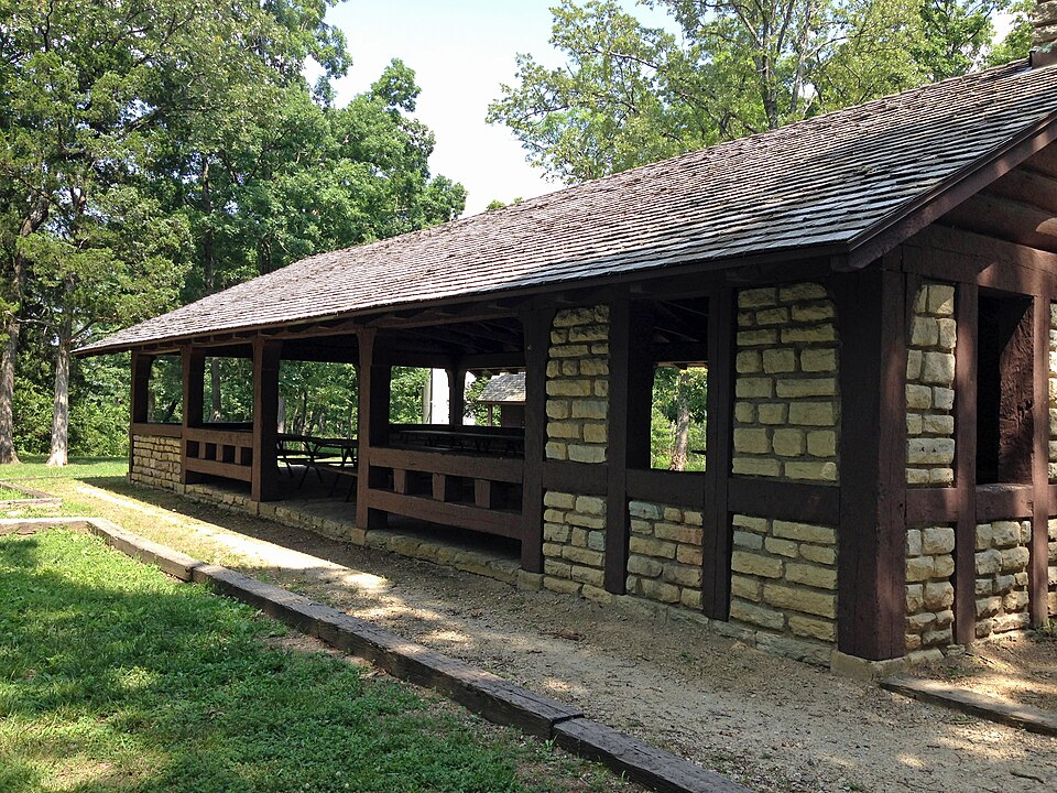
Listed on the National Register of Historic Places in 1985.
One of 5 National Register listings published here for Washington County · listed in 1985 · category: District.
Sources: the case file at the National Archives · the National Register database, National Park Service
Regional context, not property-specific evidence. The federal wildfire occurrence database lists 67 fires within 5 miles of Washington State Park CCC Historic District between 1992 and 2018, burning about 666 acres in total. None started naturally. 11 were recorded as arson. Distance is straight-line from the map coordinates, so a fire counted here may appear on a neighbouring settlement's page as well.
| Reported cause | Fires |
|---|---|
| Missing data/not specified/undetermined | 27 |
| Debris and open burning | 19 |
| Arson/incendiarism | 11 |
| Equipment and vehicle use | 4 |
| Smoking | 3 |
| Recreation and ceremony | 2 |
| Railroad operations and maintenance | 1 |
The most recent of them, most recent first, with the day each was reported and the service that recorded it.
| Date | Cause | Size | Reported by | Name on the report |
|---|---|---|---|---|
| 8 May 2014 | Missing data/not specified/undetermined | 1.0 acres | Missouri Department of Conservation | not named |
| 1 May 1997 | Debris and open burning | 1.0 acres | Missouri Department of Conservation | not named |
| 9 April 2011 | Debris and open burning | 1.0 acres | Missouri Department of Conservation | not named |
| 5 April 1992 | Arson/incendiarism | 3.0 acres | Missouri Department of Conservation | not named |
| 4 April 2018 | Missing data/not specified/undetermined | under an acre | Missouri Department of Conservation | 176456-05007-04042018-1829 |
| 4 April 2016 | Missing data/not specified/undetermined | 2.0 acres | Missouri Department of Conservation | 135311-05007-04042016-1613 |
| 2 April 1994 | Arson/incendiarism | 48 acres | Missouri Department of Conservation | not named |
| 18 April 1994 | Smoking | 5.0 acres | Missouri Department of Conservation | not named |
Regional context, not property-specific evidence. The federal mineral resources record lists 63 workings within 5 miles of Washington State Park CCC Historic District: 48 past producers, 9 producers, 4 prospects, 1 unknown. 9 still produce. What was taken out: Barium-Barite, Lead, Lead, Zinc, Iron. Distance is straight-line from the map coordinates, so a quarry counted here may appear on a neighbouring settlement's page as well.
| Where | Site | Commodity | Status | Recorded |
|---|---|---|---|---|
| Gray's Diggings | Zinc, Barium-Barite | Past Producer | ||
| Mammoth Mine | Barium-Barite, Clay, Lead, Zinc | Past Producer | ||
| Unknown - Shale & Clay | Clay | Past Producer | ||
| Skewe's & Valle's Copper Mines | Copper | Past Producer | ||
| Unknown - Copper | Copper | Past Producer | ||
| De Lore Prospect | Iron | Past Producer | ||
| Unknown - Iron | Iron | Past Producer | ||
| Vineland Tunnel & Hill Shaft | Iron | Past Producer | ||
| Campbell Mine | Lead, Zinc | Past Producer | ||
| Elliot Mines | Lead, Zinc | Past Producer |
Regional context, not property-specific evidence. The National Weather Service names Potosi, the town this property stands in, in 78 storm reports between 1993 and 2025: 50 hail, 19 thunderstorm wind, 5 tornado, 2 flash flood. The reports record 7 injuries. Each account below is quoted exactly as the forecast office filed it, from the NOAA Storm Events Database, and each date opens the federal record of that event.
| When | Event | Place named | Harm | What the report says |
|---|---|---|---|---|
| October 2004 | Tornado (F1) | Potosi | 7 hurt | The 1st in a series of 5 small tornadoes struck just northeast of Potosi along Highway 21. The Potosi Lumberyard was severely damaged. Seven people were injured with one kept overnight at a local hospital. |
| April 1993 | Tornado (F1) | Potosi | $500,000 | A small tornado initially touched down near the intersection of Highway P and State Road 8, damaging a door and windows of a large garage. The tornado then traveled across a city park damaging several trees, sections of a chain-linked fence, and several advertisement bill boards. Before lifting numerous trees were downed, several mobile homes were flipped, and minor roof damage was caused to a service station just east of the intersection of State Roads 8 and 21. |
| July 1995 | Thunderstorm Wind | Potosi | $300 | Large trees and power lines were blown down just south of Potosi. |
| November 2024 | Heavy Rain | Potosi | - | A Cocorahs station 3.2 W Potosi measured 8.8 inches of storm total rainfall between November 4th and 5th. |
| August 2023 | Thunderstorm Wind | Potosi | - | Thunderstorm winds blew down numerous trees, tree limbs and power lines from Potosi to Mineral Point. |
| April 2015 | Tornado (EF1) | Potosi | - | The tornado formed and caused damage on the west side of Potosi. Roof shingles were blown off several church buildings, trees were downed, and a mobile home used for storage was destroyed. The tornado moved east-southeast down High Street in Potosi causing roof damage to several businesses, downed trees, power lines and business signs. The tornado crossed Highway 21 and continued along Highway 8 causing tree damage in the Spring Town Road area. About a half mile east of the Potosi city limits the tornado destroyed a building at a saw mill along Highway 8. The tornado continued for about another half mile causing tree damage and then dissipated. |
| April 2015 | Flash Flood | Potosi | - | Up to three inches of rain fell in a short amount of time causing flash flooding in Potosi. Mine A Breton Creek overflowed its banks in town onto Jefferson Street. Several water rescues had to be made in this area. |
| June 2011 | Flash Flood | Potosi | - | Up to two inches of rain fell in a short amount of time causing flash flooding. Several roads were flooded including Highway E between Blackwell and Cadet. |
| January 2007 | Flood | Potosi | - | Several inches of rain caused flooding of small creeks and streams and low-water crossings mainly across southern Washington County. |
| April 2006 | Thunderstorm Wind | Potosi | - | Thunderstorm wind gusts knocked down some trees and power lines. |
| July 2006 | Thunderstorm Wind | Potosi | - | Numerous trees, tree limbs and power lines were blown down. Several of the trees fell onto homes and businesses causing minor to moderate damage. Also, some roofs were partially blown off causing minor damage. |
| April 2005 | Hail | Potosi | - | A storm spotter reported 3/4 inch hail in Potosi. |
| April 2005 | Hail | Potosi | - | A storm spotter reported 1 inch hail in Potosi. |
| April 2005 | Hail | Potosi | - | Local law enforcement reported nickel size hail in Potosi. |
| May 2005 | Hail | Potosi | - | Storm spotters reported 1 inch hail in Potosi for several minutes. |
| November 2005 | Thunderstorm Wind | Potosi | - | The local newspaper reported some trees down in Potosi from thunderstorm winds. |
| November 2005 | Thunderstorm Wind | Potosi | - | Local law enforcement reported scattered trees down. |
| May 2004 | Hail | Potosi | - | The local fire department reported golfball size hail. |
| June 2004 | Hail | Potosi | - | Local law enforcement reported nickel size hail. |
| October 2004 | Tornado (F0) | Potosi | - | The second tornado struck 1 mile northeast of Potosi along State Route E. One mobile home and a storage building were damaged. Several trees were either snapped off at the trunk or uprooted. |
| October 2004 | Tornado (F0) | Potosi | - | The third tornado was first observed in an open field about 1.5 miles east northeast of Potosi. A few large trees were either uprooted or snapped off. |
| August 2004 | Hail | Potosi | - | A cooperative observer reported golfball size hail west of Potosi. |
| April 2003 | Hail | Potosi | - | Storm spotters reported 3/4 inch hail. |
| May 2003 | Hail | Potosi | - | Storm spotters reported golfball size hail south of Potosi. |
| May 2003 | Thunderstorm Wind | Potosi | - | Local law enforcement reported power lines down and transformers damaged. |
| March 2002 | Hail | Potosi | - | The public reported a brief period of golfball size hail in Potosi. |
| May 2002 | Hail | Potosi | - | Storm spotters reported nickel size hail in Potosi. |
| August 2002 | Thunderstorm Wind | Potosi | - | Thunderstorm wind gusts downed some trees and power lines in Potosi. At least 200 customers lost electric power. |
| October 2001 | Thunderstorm Wind | Potosi | - | The County Sheriff reported trees down along Highway 185. |
| April 1998 | Hail | Potosi | - | A severe storm spotter reported 3/4 inch hail. |
| May 1997 | Hail | Potosi | - | Skywarn spotters reported 3/4 inch hail. |
| May 1997 | Hail | Potosi | - | Skywarn spotters reported 1 inch hail. |
| May 1995 | Hail | Potosi | - | The county sheriff reported quarter-size hail. |
| April 1994 | Hail | Potosi | - | Reported by a county sheriff deputy. |
| March 2025 | Hail | Potosi | - | no account filed |
| June 2011 | Hail | Potosi | - | no account filed |
| March 2009 | Hail | Potosi | - | no account filed |
| June 2009 | Hail | Potosi | - | no account filed |
| August 2008 | Hail | Potosi | - | no account filed |
| March 2008 | Hail | Potosi | - | no account filed |
| April 2007 | Hail | Potosi | - | no account filed |
| April 2007 | Hail | Potosi | - | no account filed |
| April 2007 | Hail | Potosi | - | no account filed |
| March 2006 | Hail | Potosi | - | no account filed |
| March 2006 | Hail | Potosi | - | no account filed |
| March 2006 | Hail | Potosi | - | no account filed |
| March 2006 | Hail | Potosi | - | no account filed |
| April 2006 | Hail | Potosi | - | no account filed |
| April 2006 | Hail | Potosi | - | no account filed |
| April 2006 | Hail | Potosi | - | no account filed |
| April 2006 | Hail | Potosi | - | no account filed |
| April 2006 | Hail | Potosi | - | no account filed |
| April 2006 | Hail | Potosi | - | no account filed |
| April 2006 | Hail | Potosi | - | no account filed |
| April 2006 | Hail | Potosi | - | no account filed |
| July 2006 | Hail | Potosi | - | no account filed |
| April 2005 | Hail | Potosi | - | no account filed |
| September 2005 | Thunderstorm Wind | Potosi | - | no account filed |
| May 2004 | Hail | Potosi | - | no account filed |
| May 2004 | Hail | Potosi | - | no account filed |
No historic map-sheet match is published for this property yet. That does not mean no map exists. This record needs a coordinate-quality review before it can be joined to a sheet boundary. Browse the county's mapped places while that work is pending.
| National Archives record | The nomination case file for reference 85000517 in Record Group 79. |
| Washington County | All 5 listed properties in this county. |