BlockBefore
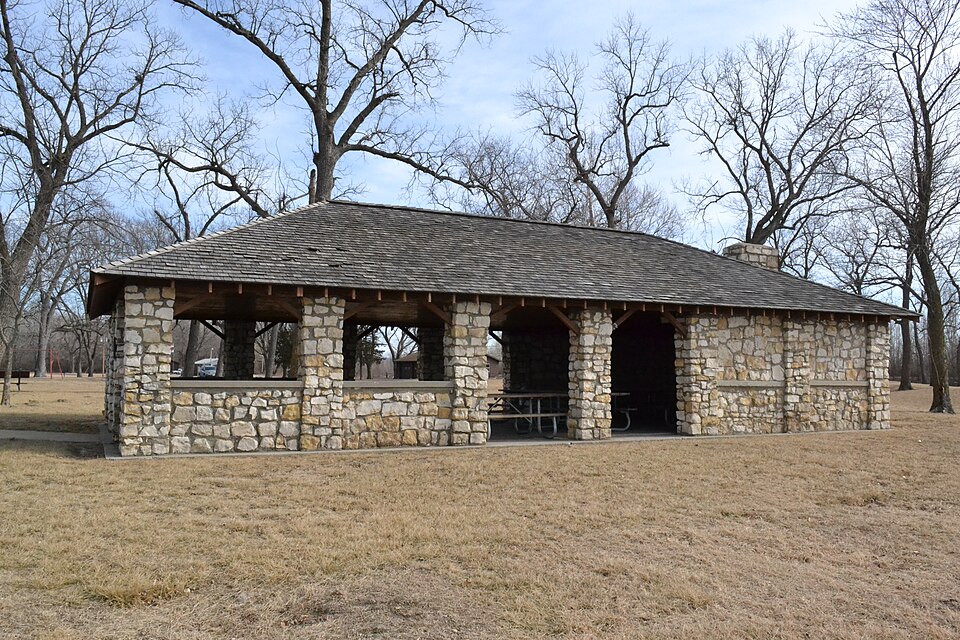
Photograph of Sugar Lake State Park Open Shelter
Photograph by 25or6to4, CC BY-SA 4.0. Via Wikimedia Commons.

Sugar Lake State Park Open Shelter

Built in 1934 (National Park Service rustic). Listed on the National Register of Historic Places in 1985.

From the record

One of 63 National Register listings published here for Buchanan County · listed in 1985 · category: Building · built in 1934, National Park Service rustic.

Sources: the case file at the National Archives · the National Register database, National Park Service

The listing

  • What is counted as historic. The nomination lists 1 building as contributing to the listing.
  • Address. Off MO 138, Rushville, 64484
  • When was it listed? February 1985
  • Category. building
  • Also known as. ECW Architecture in Missouri State Parks 1933-1942 TR
  • Township. Rush township
  • When was it built? 1934
  • Architectural style. National Park Service rustic
  • National Register reference number. 85000522 - the number the National Park Service assigned this property when it was listed, and the key its nomination file is catalogued under at the National Archives.

The ground it stands on

5,625 words

The chapter on Rush Township in History of Buchanan County and the City of St. Joseph and Representative Citizens : 1826 to 1904, published 1904; The History of Buchanan County, Missouri : Containing a History of the County, Its Cities, Towns, Etc., Biographical Sketches of Its Citizens, Buchanan County in the Late War, General and Local Statisics, Portraits of Early Settlers and Prominent Men, History of Missouri, Map of Buchanan County, Etc., Etc, published 1881 names Rushville. This is what it says, exactly as the scans read.

In 1884, the northern portion of Winthrop went into the river, and the ravages of the flood were so great as to necessitate the abandonment of a railroad station between Winthrop and Rushville, called "Paw-Paw." For over three years trains were run to Sugar Lake, where Armour station was erected, and thence to Atchison. Last year, however, the Rock Island and Santa Fe companies built tracks along the old route and their trains no longer go to Armour.

Passage source: History of Buchanan County and the City of St. Joseph and Representative Citizens : 1826 to 1904, published 1904.

farmer, section 23, postoffice Rushville, was bom- in Warren County,. Kentucky, October 25, 181 5, and when eleven years of age his father moved to Lafayette County, Missouri, where he was raised and educated. He there remained till 1838, when he moved to Buchanan County, and has since been engaged in agricultural pursuits. His farm contains eighty acres comfortably improved. He acted as justice of the peace for twelve years. Mr. A. was married August 8, 1840, to Miss Dicy A. Trapp, who was born in Jackson County, Missouri, May 29, 1828. She died September 15, 1870, leaving twelve children, six of whom are living : Jasper C, Houston, Polly A., William, George W., and James. Mr. A. is a member of the Christian Church.

Passage source: The History of Buchanan County, Missouri : Containing a History of the County, Its Cities, Towns, Etc., Biographical Sketches of Its Citizens, Buchanan County in the Late War, General and Local Statisics, Portraits of Early Settlers and Prominent Men, History of Missouri, Map of Buchanan County, Etc., Etc, published 1881.

Machine-read from a century-old scan, so expect the errors a machine makes: misspelled names, dropped words, stray characters.

Read the whole chapter on Rush Township - 5,625 words on its settlement, mills, schools and churches.

Fires near this property

25 since 2005

Regional context, not property-specific evidence. The federal wildfire occurrence database lists 25 fires within 5 miles of Sugar Lake State Park Open Shelter between 2005 and 2018, burning about 1,094 acres in total. 1 started naturally. 7 were recorded as arson. Distance is straight-line from the map coordinates, so a fire counted here may appear on a neighbouring settlement's page as well.

Reported cause Fires
Missing data/not specified/undetermined10
Arson/incendiarism7
Debris and open burning5
Smoking2
Natural1

The most recent of them, most recent first, with the day each was reported and the service that recorded it.

DateCause SizeReported by Name on the report
11 September 2015Arson/incendiarismunder an acreKansas Forest Service150750
8 August 2018Arson/incendiarismunder an acreKansas Forest Service180751
10 August 2008Missing data/not specified/undetermined1.0 acresAtchison Countynot named
6 July 2018Smokingunder an acreKansas Forest Service180648
15 June 2017Arson/incendiarismunder an acreAtchison County170536
13 May 2018Missing data/not specified/undeterminedunder an acreKansas Forest Service180432
17 April 2018Arson/incendiarism667 acresMissouri Department of Conservation176765-00000-04172018-1710
15 April 2008Arson/incendiarism1.0 acresAtchison Countynot named

Every fire recorded in Buchanan County

Mines and quarries near this property

8 within 5 miles

Regional context, not property-specific evidence. The federal mineral resources record lists 8 workings within 5 miles of Sugar Lake State Park Open Shelter: 8 past producers. None of them still produces. What was taken out: Stone, Crushed/Broken. Distance is straight-line from the map coordinates, so a quarry counted here may appear on a neighbouring settlement's page as well.

Where SiteCommodity StatusRecorded
Bramble QuarryStone, Crushed/BrokenPast Producer
Rose QuarryStone, Crushed/BrokenPast Producer
Steele QuarryStone, Crushed/BrokenPast Producer
Unknown LsStone, Crushed/BrokenPast Producer

Every working recorded in Buchanan County

Storms near this property

10 since 2000

Regional context, not property-specific evidence. The National Weather Service names Rushville, the town this property stands in, in 10 storm reports between 2000 and 2025: 5 hail, 5 thunderstorm wind. No death or injury is recorded in these reports. Each account below is quoted exactly as the forecast office filed it, from the NOAA Storm Events Database, and each date opens the federal record of that event.

WhenEvent Place namedHarm What the report says
March 2025Thunderstorm WindRushville-Downed wires and numerous power outages between Rushville and De Kalb.
April 2022Thunderstorm WindRushville-A detached garage was pushed off its foundation in Rushville.
April 2016Thunderstorm WindRushville-A few power lines were down near Rushville.
July 2015Thunderstorm WindRushville-A tree limb was blown down onto a car. The power was also knocked out.
June 2009Thunderstorm WindRushville-Trees were reported to have been blown down.
May 2018HailRushville-no account filed
May 2010HailRushville-no account filed
May 2000HailRushville-no account filed

Every storm recorded in Buchanan County

Map coverage status

No historic map-sheet match is published for this property yet. That does not mean no map exists. This record needs a coordinate-quality review before it can be joined to a sheet boundary. Browse the county's mapped places while that work is pending.

Listed places nearby

1 within 8 miles

Other National Register properties close enough to walk or drive between, ordered by distance from this one. Both positions come from the same geocoding pass that matched these properties to their map sheets.

Photograph PropertyDistance Listed
Enoch Madison Fenton House5.9 miles1982

Sources for this property

National Archives recordThe nomination case file for reference 85000522 in Record Group 79.
Buchanan CountyAll 63 listed properties in this county.

Provenance

  • Listing record. National Park Service National Register of Historic Places, listed-properties dataset, current to 2026-05-22.
  • Map join. Address geocoded through the United States Census geocoder, then tested against the published boundary of every sheet in the USGS Historical Topographic Map Collection.
  • How this page is made. Listing fields come from federal records; map-sheet coverage is a labelled coordinate-to-boundary calculation, not a source-field claim.
  • Wildfire. Short, Karen C. 2022. Spatial wildfire occurrence data for the United States, 1992-2020 [FPA_FOD_20221014]. 6th Edition. Fort Collins, CO: Forest Service Research Data Archive. https://doi.org/10.2737/RDS-2013-0009.6 Collected with United States Government funding and usable without additional permissions or fees.
  • Mines and quarries. USGS Mineral Resources Data System (MRDS) https://mrdata.usgs.gov/mrds/ A work of the United States government, no copyright under 17 U.S.C. 105.
  • Storms. NOAA National Centers for Environmental Information, Storm Events Database https://www.ncei.noaa.gov/stormevents/ A work of the United States government, no copyright under 17 U.S.C. 105. Narratives are quoted verbatim from the National Weather Service report and are not edited or summarised.