 Block
From the record
One of 2 National Register listings published here for Wayne County · listed in 1985 · category: District.
Sources: the case file at the National Archives · the National Register database, National Park Service
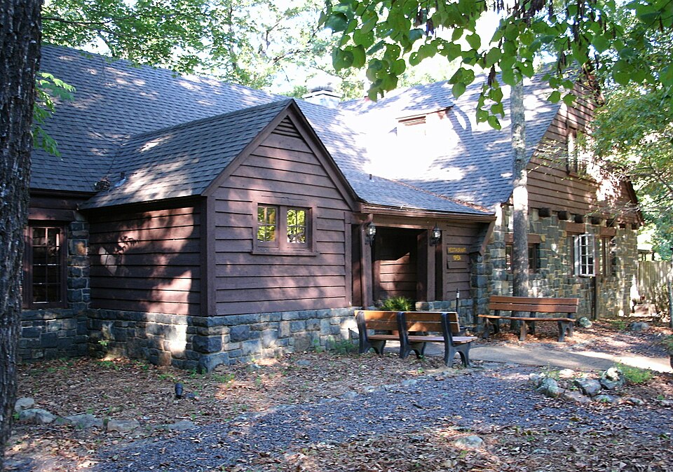
Listed on the National Register of Historic Places in 1985.
One of 2 National Register listings published here for Wayne County · listed in 1985 · category: District.
Sources: the case file at the National Archives · the National Register database, National Park Service
Regional context, not property-specific evidence. The federal wildfire occurrence database lists 32 fires within 5 miles of Sam A. Baker State Park Historic District between 1992 and 2020, burning about 496 acres in total. None started naturally. 5 were recorded as arson. Distance is straight-line from the map coordinates, so a fire counted here may appear on a neighbouring settlement's page as well.
| Reported cause | Fires |
|---|---|
| Debris and open burning | 14 |
| Missing data/not specified/undetermined | 7 |
| Arson/incendiarism | 5 |
| Recreation and ceremony | 4 |
| Smoking | 1 |
| Equipment and vehicle use | 1 |
The most recent of them, most recent first, with the day each was reported and the service that recorded it.
| Date | Cause | Size | Reported by | Name on the report |
|---|---|---|---|---|
| 18 August 1994 | Equipment and vehicle use | 1.0 acres | Missouri Department of Conservation | not named |
| 9 April 2014 | Debris and open burning | 6.0 acres | Missouri Department of Conservation | not named |
| 6 April 2018 | Debris and open burning | under an acre | Missouri Department of Conservation | 176454-11111-04062018-1652 |
| 22 April 2014 | Debris and open burning | 5.0 acres | Missouri Department of Conservation | not named |
| 15 April 1997 | Debris and open burning | 15 acres | Missouri Department of Conservation | not named |
| 4 March 2017 | Recreation and ceremony | 135 acres | Missouri Department of Conservation | not named |
| 31 March 1997 | Debris and open burning | 1.0 acres | Missouri Department of Conservation | not named |
| 30 March 1997 | Debris and open burning | 1.0 acres | Missouri Department of Conservation | not named |
Regional context, not property-specific evidence. The federal mineral resources record lists 20 workings within 5 miles of Sam A. Baker State Park Historic District: 7 occurrences, 6 past producers, 6 prospects, 1 producer. 1 still produces. What was taken out: Iron, Stone, Crushed/Broken, Sand and Gravel, Construction, Zinc. Distance is straight-line from the map coordinates, so a quarry counted here may appear on a neighbouring settlement's page as well.
| Where | Site | Commodity | Status | Recorded |
|---|---|---|---|---|
| Unknown | Sand and Gravel, Construction | Past Producer | ||
| Unknown | Zinc | Prospect | ||
| Harris Lime Co. Quarry & Plant | Stone, Crushed/Broken | Producer | ||
| Unknown | Stone, Crushed/Broken | Past Producer | ||
| Unknown | Stone, Crushed/Broken | Past Producer | ||
| Unknown | Stone, Crushed/Broken | Past Producer | ||
| Unknown | Stone, Crushed/Broken | Prospect | ||
| Kelly Land | Iron | Occurrence | ||
| Kinkad Land | Iron | Occurrence | ||
| Kinkad Land | Iron | Prospect |
Regional context, not property-specific evidence. The National Weather Service names Patterson, the town this property stands in, in 22 storm reports between 1993 and 2022: 9 hail, 5 flood, 4 flash flood, 2 thunderstorm wind. No death or injury is recorded in these reports. Each account below is quoted exactly as the forecast office filed it, from the NOAA Storm Events Database, and each date opens the federal record of that event.
| When | Event | Place named | Harm | What the report says |
|---|---|---|---|---|
| April 2004 | Tornado (F1) | Patterson | $100,000 | Trees and power lines were blown down. Two businesses and about six homes were severely damaged when most of their roofing was blown off. The businesses were a beauty shop and a post office. A dozen barns and sheds were destroyed. Several vehicles and some farm machinery was damaged. Peak winds were estimated near 100 MPH. Power outages affected about 100 people. Some county roads and secondary highways were blocked. The damage path began on Highway B and ended at the junction of Highway 34 and FF Highway. Most of the structural damage was in Patterson at the junction of Highways 34 and FF. |
| December 2015 | Tornado (EF1) | Patterson | $50,000 | Peak winds were estimated near 105 mph. A couple dozen tree trunks were snapped, and several large tree branches were broken. Highway 34 was closed due to downed and uprooted trees. The tornado tracked along or just north of Highway 34, but it lifted before crossing U.S. Highway 67. The tornado tracked through forested areas and wetlands near the St. Francis River. |
| August 1998 | Flash Flood | Patterson | $20,000 | A nearly stationary cluster of thunderstorms dumped excessive rainfall amounts over a very small portion of Wayne County near Sam A. Baker State Park. Unofficial rainfall estimates were between 4 and 6 inches just north of Patterson, most of which fell within 3 hours. Clark Creek overflowed across low water bridges near Patterson. |
| September 2012 | Thunderstorm Wind | Patterson | $10,000 | Numerous trees were blown down in north central Wayne County, including areas along Highway 143 at Sam A. Baker State Park. |
| January 2007 | Flood | Patterson | - | At Patterson, where flood stage is 16 feet, the St. Francis River crested at 16.20 feet. This resulted in minor flooding of low-lying fields and woods near the river. |
| April 2007 | Flood | Patterson | - | Minor flooding of fields and woodlands occurred along the St. Francis River. At Patterson, the river crested about six inches above the flood stage of 16 feet around 1:30 A.M. on the 15th. |
| May 2007 | Flood | Patterson | - | Minor flooding of the St. Francis River occurred. At Patterson, where flood stage is 16 feet, the river crested at 18.31 feet around mid-morning on May 4. Some low-lying fields and woodlands near the river were flooded. Rainfall at Patterson was unofficially measured at 4 inches. |
| March 2006 | Flood | Patterson | - | Minor flooding of the St. Francis River occurred after repeated episodes of widespread thunderstorms. At Patterson, where flood stage is 16 feet, the river crested at 16.01 feet. This resulted in minor flooding of bottomland and surrounding low-lying areas. |
| July 2003 | Thunderstorm Wind | Patterson | - | Roads were blocked by downed trees. |
| July 2001 | Flash Flood | Patterson | - | Torrential rain from persistent thunderstorms caused Big Creek to rise rapidly during the early morning hours. Prior to reaching bankful, campers were evacuated from the Sam A. Baker State Park due to rapid rises on Big Creek. |
| June 1998 | Flash Flood | Patterson | - | Persistent thunderstorms during the morning produced flooding rains. The St. Francis River rose rapidly and threatened Route 34 for a time. Water was reported over a road south of Greenville. |
| August 1998 | Flash Flood | Patterson | - | A slow-moving band of thunderstorms produced heavy rain over the part of Wayne County that experienced flash flooding on the 10th. Although the duration of heavy rain was shorter than the previous day, amounts were estimated as high as 2 inches in one hour. Lower water bridges and some secondary roads were flooded along Clarks Creek. Highway 34 was flooded in spots between Piedmont and Patterson. |
| April 1993 | Hail | Patterson | - | The Piedmont Police Department reported 1.00-inch-diameter hail in Piedmont. Missouri Highway Patrol Troop E reported 0.75-inch-diameter hail at Patterson. |
| April 2022 | Hail | Patterson | - | no account filed |
| April 2021 | Hail | Patterson | - | no account filed |
| August 2012 | Hail | Patterson | - | no account filed |
| May 2011 | Hail | Patterson | - | no account filed |
| February 2006 | Hail | Patterson | - | no account filed |
| December 2006 | Flood | Patterson | - | no account filed |
| July 2001 | Hail | Patterson | - | no account filed |
| May 1996 | Hail | Patterson | - | no account filed |
| October 1996 | Hail | Patterson | - | no account filed |
No historic map-sheet match is published for this property yet. That does not mean no map exists. This record needs a coordinate-quality review before it can be joined to a sheet boundary. Browse the county's mapped places while that work is pending.
Other National Register properties close enough to walk or drive between, ordered by distance from this one. Both positions come from the same geocoding pass that matched these properties to their map sheets.
| Photograph | Property | Distance | Listed |
|---|---|---|---|
| Fort Benton | 5.3 miles | 2002 |
| National Archives record | The nomination case file for reference 85000540 in Record Group 79. |
| Wayne County | All 2 listed properties in this county. |