
BlockBefore
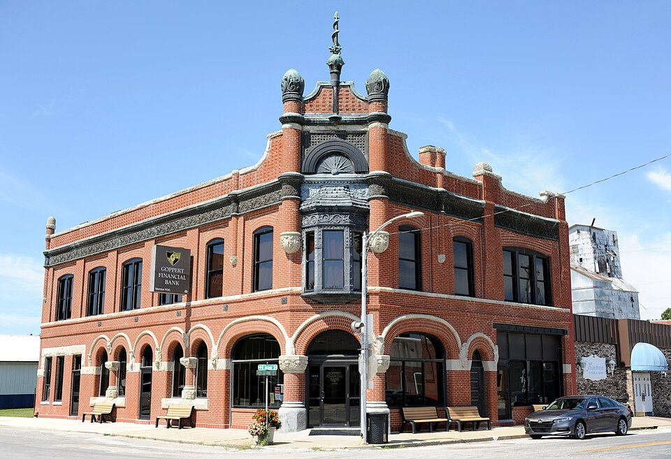
Photograph of Farmers Bank Building
Photograph by Keith Snyder, CC BY-SA 4.0. Via Wikimedia Commons.

Farmers Bank Building

Listed on the National Register of Historic Places in 1994.

From the record

One of 5 National Register listings published here for Carroll County · listed in 1994 · category: Building.

Sources: the case file at the National Archives · the National Register database, National Park Service · the Wikipedia article

The listing

  • What is counted as historic. The nomination lists 1 building as contributing to the listing.
  • Address. 114 S. Pine St., Norborne, 64668
  • When was it listed? July 1994
  • Category. building
  • Township. Egypt township
  • Architectural style. Romanesque Revival architecture
  • National Register reference number. 94000702 - the number the National Park Service assigned this property when it was listed, and the key its nomination file is catalogued under at the National Archives.

What happened here

An account from the chapter on Egypt township. The inset identifies its exact source book and publication year.

From History of Carroll County, Missouri : Carefully Written and Compiled from the Most Authentic Official and Private Sources, Including a History of Its Townships, Cities, Towns and Villages, Together with a Condensed History of Missouri ; the Constitution of the United States, and State of Missouri ; a Military Record of Its Volunteers in Either Army of the Great Civil War ; General and Local Statistics ; Miscellany ; Reminiscences, Grave, Tragic and Humorous ; Biographical Sketches of Prominent Men and Citizens Identified with the Interests of the Country, published 1881 - Egypt Township

George W. Metcalf

George W. Metcalf was born on the 10th day of February, 1839, in White county, Ind., near the famous Tippecanoe battle ground. In 1845 he moved to Carroll county, Mo., with the family. His father, J. E. Metcalf, was formerly of New York; he ;died in 1865, with cholera, leaving George W., who was the oldest son, to look after the support of the family.

Read the rest of this passage

The ground it stands on

20,439 words

The chapter on Egypt Township in History of Carroll County, Missouri : Carefully Written and Compiled from the Most Authentic Official and Private Sources, Including a History of Its Townships, Cities, Towns and Villages, Together with a Condensed History of Missouri ; the Constitution of the United States, and State of Missouri ; a Military Record of Its Volunteers in Either Army of the Great Civil War ; General and Local Statistics ; Miscellany ; Reminiscences, Grave, Tragic and Humorous ; Biographical Sketches of Prominent Men and Citizens Identified with the Interests of the Country, published 1881 names Norborne. This is what it says, exactly as the scans read.

Among the earlier settlers were Geo. Cloudis of Virginia, Benedict Stemple of Germany, John Fuchs, - Wolfl', Michael Wagner and John Coleman, who settled here in 1836. Maj. George Diegel who represented this county in the lower house of the state assemblj% and was afterward elected state register of lands came in 1843. All the first settlers of Egypt township located along the bluff that skirts the bottom land on the west, about seven miles from the Missouri river, and opened farms in the prairie bottom. John Deiterich and John Fox located their farms in the spring of 1841 in a northwesterly direction from where Norborne now stands. Other settlers soon followed, among w'hom were Jack Dresber, Stotts, Knipschildt, Samuel Metcalf, Wm. Marlow from Kentucky, and John Lee. Few if any settlements were made on the bottom lands proper until after 1850, the settlers deeming the low-lands of little value for cultivation. Besides their means for building being limited, and the material being too heavy for transportation any distance, they wisely concluded to ereet their rude residences near the bluffy timber where the hewn logs were easy of access, and where, also, they would find protection from the storms from the west.

Passage source: History of Carroll County, Missouri : Carefully Written and Compiled from the Most Authentic Official and Private Sources, Including a History of Its Townships, Cities, Towns and Villages, Together with a Condensed History of Missouri ; the Constitution of the United States, and State of Missouri ; a Military Record of Its Volunteers in Either Army of the Great Civil War ; General and Local Statistics ; Miscellany ; Reminiscences, Grave, Tragic and Humorous ; Biographical Sketches of Prominent Men and Citizens Identified with the Interests of the Country, published 1881.

Norborae takes its name from Norborne B. Coats,' who wdth John Dietrich, the original owner of the land, on which the town is built, founded the' village in 1868. The first incorporation took place in 1874, when a full set of town officers was chosen. - The town is located on the east half of the northwest of section 23, and is ten miles west of Carrollton, on the Wabash, St. Louis & Pacific Railroad. The first dwelling house was built by Harvey McCoy, the first store was kept by January & Snoddy; the first school taught was by J. N. Cunningham, in the Lutheran church.

Passage source: History of Carroll County, Missouri : Carefully Written and Compiled from the Most Authentic Official and Private Sources, Including a History of Its Townships, Cities, Towns and Villages, Together with a Condensed History of Missouri ; the Constitution of the United States, and State of Missouri ; a Military Record of Its Volunteers in Either Army of the Great Civil War ; General and Local Statistics ; Miscellany ; Reminiscences, Grave, Tragic and Humorous ; Biographical Sketches of Prominent Men and Citizens Identified with the Interests of the Country, published 1881.

Machine-read from a century-old scan, so expect the errors a machine makes: misspelled names, dropped words, stray characters.

Read the whole chapter on Egypt Township - 20,439 words on its settlement, mills, schools and churches.

Mines and quarries near this property

1 within 5 miles

Regional context, not property-specific evidence. The federal mineral resources record lists 1 working within 5 miles of Farmers Bank Building: 1 past producer. None of them still produces. What was taken out: Stone, Crushed/Broken. Distance is straight-line from the map coordinates, so a quarry counted here may appear on a neighbouring settlement's page as well.

Where SiteCommodity StatusRecorded
Lakeview QuarryStone, Crushed/BrokenPast Producer

Every working recorded in Carroll County

Storms near this property

34 since 1998

Regional context, not property-specific evidence. The National Weather Service names Norborne, the town this property stands in, in 34 storm reports between 1998 and 2025: 19 hail, 8 thunderstorm wind, 3 flash flood, 2 tornado. No death or injury is recorded in these reports. Each account below is quoted exactly as the forecast office filed it, from the NOAA Storm Events Database, and each date opens the federal record of that event.

WhenEvent Place namedHarm What the report says
March 2006Tornado (F0)Norborne$250,000F0 tornado touched down around Norborne at 0944 CST and then lifted 2 miles east of Carrollton at 1005 CST. Damage was noted to buildings...trees and power lines.
June 2009Thunderstorm WindNorborne$20,000Spotter reported thunderstorm wind gusts estimated to be up to 100 mph. Winds were gusting up to 60 mph, for 10 to 15 minutes, between Norborne and Carrollton. Numerous trees and power lines were down. Several power poles were snapped.
June 2009Thunderstorm WindNorborne$5,000A part of a barn roof was ripped off. Several powerlines were also reported down.
May 2000Tornado (F1)Norborne$5,000Carroll County Emergency Management reported a tornado in open fields 4 miles south of Norborne. The tornado moved northeast for 2.5 miles, and trees and power lines were downed along its path.
June 2009Thunderstorm WindNorborne$2,000Trees and powerlines were reported down.
June 2009Thunderstorm WindNorborne$2,000Thunderstorm wind gusts to 65 mph were estimated. A 50 foot tall radio tower was blown over.
June 2007Thunderstorm WindNorborne$2,000Power poles and tree limbs were reported down.
June 2025Thunderstorm WindNorborne-Downed wires and power outages reported in the Norborne area.
August 2023Thunderstorm WindNorborne-Estimated 60 mph winds at the Casey's General Store in Norborne.
April 2019FloodNorborne-Ongoing flooding along the Missouri River continued through the month of April and into May. Several roads were closed near the banks of the Missouri River. This flooding began in mid March and due to upstream releases and continued periods of heavy rain the flooding continued into May. Monetary damages are unknown despite the entry indicating 0 dollars of damages.
August 2018Flash FloodNorborne-Route E near Stet was closed due to running water over the road.
August 2016Flash FloodNorborne-During the long duration heavy rain event across Carroll County several area roads flooded. In the city of Carrolton a few businesses had water running up, and causing water to move into these businesses. The extent or cost of the damage is unknown.
September 2016FloodNorborne-Route E along Turkey Creek was closed due to flooding. While the damage was largely minimal the amount of damage was unknown.
June 2008Flash FloodNorborne-Water reported over JJ Highway, due to the heavy rains.
May 1998HailNorborne-Quarter-size hail was reported by the public 3 miles northwest of Norborne.
June 1998HailNorborne-The Carroll county Sheriff's office reported dime to quarter-size hail in Norborne.
May 2011HailNorborne-no account filed
June 2009HailNorborne-no account filed
May 2009HailNorborne-no account filed
June 2008HailNorborne-no account filed
July 2008HailNorborne-no account filed
June 2007HailNorborne-no account filed
February 2007HailNorborne-no account filed
April 2003HailNorborne-no account filed
May 2003HailNorborne-no account filed
September 2001Thunderstorm WindNorborne-no account filed
April 2000HailNorborne-no account filed
May 2000HailNorborne-no account filed
April 1999HailNorborne-no account filed

Every storm recorded in Carroll County

Map coverage status

No historic map-sheet match is published for this property yet. That does not mean no map exists. This record needs a coordinate-quality review before it can be joined to a sheet boundary. Browse the county's mapped places while that work is pending.

Sources for this property

National Archives recordThe nomination case file for reference 94000702 in Record Group 79.
Wikipedia articleCommunity-written account of this property, licensed CC BY-SA.
Carroll CountyAll 5 listed properties in this county.

Provenance

  • Listing record. National Park Service National Register of Historic Places, listed-properties dataset, current to 2026-05-22.
  • Map join. Address geocoded through the United States Census geocoder, then tested against the published boundary of every sheet in the USGS Historical Topographic Map Collection.
  • How this page is made. Listing fields come from federal records; map-sheet coverage is a labelled coordinate-to-boundary calculation, not a source-field claim.
  • Mines and quarries. USGS Mineral Resources Data System (MRDS) https://mrdata.usgs.gov/mrds/ A work of the United States government, no copyright under 17 U.S.C. 105.
  • Storms. NOAA National Centers for Environmental Information, Storm Events Database https://www.ncei.noaa.gov/stormevents/ A work of the United States government, no copyright under 17 U.S.C. 105. Narratives are quoted verbatim from the National Weather Service report and are not edited or summarised.