BlockBefore
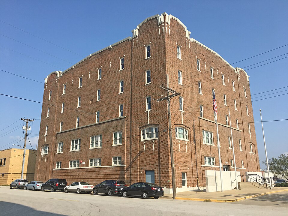
Photograph of Wheeling Corrugating Company Building
Photograph by Bartokie, CC BY-SA 4.0. Via Wikimedia Commons.

Wheeling Corrugating Company Building

Listed on the National Register of Historic Places in 1994.

From the record

“Wheeling Corrugating Company Building, also known as Cook Composites and Polymers (CCP), is a historic factory building located at North Kansas City, Missouri. It was built in 1920, and is a five-story, six-bay, rectangular reinforced concrete building faced in brick with cut stone trim.”

Wikipedia article Wheeling Corrugating Company Building, CC BY-SA 4.0.

One of 39 National Register listings published here for Clay County · listed in 1994 · category: Building.

Sources: the Wikipedia article · the case file at the National Archives · the National Register database, National Park Service
The listing

  • What is counted as historic. The nomination lists 1 building as contributing to the listing.
  • Address. 820 E. 14th Ave., North Kansas City, 64116
  • When was it listed? October 1994
  • Category. building
  • Township. Gallatin township
  • National Register reference number. 94001220 - the number the National Park Service assigned this property when it was listed, and the key its nomination file is catalogued under at the National Archives.

What happened here

An account from the chapter on Gallatin township. The inset identifies its exact source book and publication year.

From History of Clay and Platte Counties, Missouri;, published 1885 - Gallatin Township

Chapter Viii The Mexican War

Army of the West - Platte and Cole Infantry Battalion - Departure of the Expedition - Arrival of Kearney in Santa Fe - Col. Sterling Price - Capt. Morin's Platte County Company - Names of Members - The Ortiz Insurrection - Murder of Gov. Bent and Others - Battle of La Canada - Ambuscade at El Embudo - Storming and Capture of Fort Pueblo de Taos - Other Battles - Massacre and Subsequent Battle at Moro - Engagement at Cienega - The Return Home - Capt.

Read the rest of this passage

The ground it stands on

1,398 words

This property stands in Gallatin Township. History of Clay and Platte Counties, Missouri;, published 1885 gives that township a chapter of its own.

The chapter covers boundary and physical features, villages in this township, barry, harlem, moscow, arnold's station.

Machine-read from a century-old scan, so expect the errors a machine makes: misspelled names, dropped words, stray characters.

Read the whole chapter on Gallatin Township - 1,398 words on its settlement, mills, schools and churches.

Fires near this property

112 since 2007

Regional context, not property-specific evidence. The federal wildfire occurrence database lists 112 fires within 5 miles of Wheeling Corrugating Company Building between 2007 and 2020, burning about 47 acres in total. None started naturally. 12 were recorded as arson. Distance is straight-line from the map coordinates, so a fire counted here may appear on a neighbouring settlement's page as well.

Reported cause Fires
Missing data/not specified/undetermined68
Arson/incendiarism12
Recreation and ceremony8
Smoking7
Equipment and vehicle use6
Debris and open burning6
Misuse of fire by a minor2
Power generation/transmission/distribution2
Fireworks1

The most recent of them, most recent first, with the day each was reported and the service that recorded it.

DateCause SizeReported by Name on the report
7 September 2007Missing data/not specified/undetermined1.0 acresMissouri State Fire Marshal's Officenot named
7 September 2007Missing data/not specified/undeterminedunder an acreMissouri State Fire Marshal's Officenot named
5 September 2007Missing data/not specified/undeterminedunder an acreMissouri State Fire Marshal's Officenot named
30 September 2007Missing data/not specified/undeterminedunder an acreMissouri State Fire Marshal's Officenot named
29 September 2018Debris and open burningunder an acreKansas Forest Service24406
29 September 2017Missing data/not specified/undeterminedunder an acreWyandotte County23456
28 September 2007Recreation and ceremony2.0 acresMissouri State Fire Marshal's Officenot named

Every fire recorded in Clay County

Mines and quarries near this property

10 of 56 shown

Regional context, not property-specific evidence. The federal mineral resources record lists 56 workings within 5 miles of Wheeling Corrugating Company Building: 49 past producers, 7 producers. 7 still produce. What was taken out: Stone, Crushed/Broken, Clay, Sand and Gravel, Construction, Perlite. Distance is straight-line from the map coordinates, so a quarry counted here may appear on a neighbouring settlement's page as well.

Where SiteCommodity StatusRecorded
Lite Weight Products Perlite PlantPerliteProducer
Unknown-Ls and ShaleClay, Stone, Crushed/BrokenPast Producer
Holliday Sand & Gravel PlantSand and Gravel, ConstructionProducer
Randolph DredgeSand and Gravel, ConstructionProducer
UnknownClayPast Producer
UnknownSand and Gravel, ConstructionPast Producer
UnknownStone, Crushed/Broken, ClayPast Producer
UnknownSand and Gravel, ConstructionPast Producer

Every working recorded in Clay County

Storms near this property

37 since 1996

Regional context, not property-specific evidence. The National Weather Service names North Kansas City, the town this property stands in, in 37 storm reports between 1996 and 2025: 14 hail, 14 thunderstorm wind, 6 flash flood, 2 flood. No death or injury is recorded in these reports. Each account below is quoted exactly as the forecast office filed it, from the NOAA Storm Events Database, and each date opens the federal record of that event.

WhenEvent Place namedHarm What the report says
May 2000Tornado (F1)North Kansas City$5,000,000The tornado formed rapidly in southwest Clay County in Kansas City, MO, causing considerable damage to two auto dealerships at 39th and North Oak Trafficway. A nearby apartment complex suffered roof damage. Many trees and power lines were downed as the tornado moved east, lifting near Parvin Road and Chouteau Trafficway.
March 2006Thunderstorm WindNorth Kansas City$250,000Roof blown off Block Road at 12th and Burlington. Multiple power poles snapped off...windows and structural damage to buildings...around 10th through 12th Street and Burlington.
March 2006HailNorth Kansas City$200,000no account filed
June 2004Thunderstorm WindNorth Kansas City$5,000Damage to Ameristar casino building.
May 2025Thunderstorm WindNorth Kansas City-Numerous 2-6 inch diameter tree branches down.
May 2020Flash FloodNorth Kansas City-There was flooding on the ramp of Briarcliff and Southbound HWY 9.
April 2019FloodNorth Kansas City-Ongoing flooding along the Missouri River continued through the month of April and into May. Several roads were closed near the banks of the Missouri River. This flooding began in mid March and due to upstream releases and continued periods of heavy rain the flooding continued into May. Monetary damages are unknown despite the entry indicating 0 dollars of damages.
May 2019Flash FloodNorth Kansas City-A water rescue took place along Highway 9 and Briarcliff in Northmoor.
October 2018Flash FloodNorth Kansas City-Several roads around 169 and 69 were flooded.
July 2017Thunderstorm WindNorth Kansas City-Numerous trees of unknown size or condition were down near North Kansas City.
August 2017Flash FloodNorth Kansas City-Two water rescues occurred at Briarcliff Parkway and Highway 169 near Northmoor.
May 2016Flash FloodNorth Kansas City-North Kansas City Fire Department assisted in helping stranded motorists in high water. It is unclear to what extent the motorists needed assistance.
May 2016HailNorth Kansas City-This report was gathered via social media.
May 2013HailNorth Kansas City-Hail was reported around the downtown Kansas City airport.
May 2011Thunderstorm WindNorth Kansas City-Thunderstorm wind gusts were estimated up to 60 mph.
August 2011Thunderstorm WindNorth Kansas City-The ASOS at the downtown Kansas City Airport, measured a thunderstorm wind gust to 58 mph.
May 2008Thunderstorm WindNorth Kansas City-Trees were reported down and power out at 23rd Street and Burlington.
August 2006Flash FloodNorth Kansas City-Several cars stalled on roads and intersections...where 1.5 inches of rain fell in 40 minutes.
May 2005Thunderstorm WindNorth Kansas City-Trees downed from thunderstorm winds.
November 2016HailNorth Kansas City-no account filed
May 2011HailNorth Kansas City-no account filed
April 2010HailNorth Kansas City-no account filed
May 2010HailNorth Kansas City-no account filed
June 2008HailNorth Kansas City-no account filed
April 2008Thunderstorm WindNorth Kansas City-no account filed
July 2007HailNorth Kansas City-no account filed
March 2006HailNorth Kansas City-no account filed
June 2004Thunderstorm WindNorth Kansas City-no account filed
May 2003HailNorth Kansas City-no account filed
October 2002HailNorth Kansas City-no account filed
May 2001HailNorth Kansas City-no account filed
September 2001Thunderstorm WindNorth Kansas City-no account filed
May 1996FloodNorth Kansas City-no account filed

Every storm recorded in Clay County

Map coverage status

No historic map-sheet match is published for this property yet. That does not mean no map exists. This record needs a coordinate-quality review before it can be joined to a sheet boundary. Browse the county's mapped places while that work is pending.

Listed places nearby

5 within 8 miles

Other National Register properties close enough to walk or drive between, ordered by distance from this one. Both positions come from the same geocoding pass that matched these properties to their map sheets.

Photograph PropertyDistance Listed
Sears, Roebuck and Company Warehouse Building0.5 miles1997
Armour Theatre Building0.7 miles2008
Antioch Christian Church3.5 miles1979
Dr. James Compton House5.3 miles1979
Atkins-Johnson Farmhouse Property5.8 miles2007

Sources for this property

National Archives recordThe nomination case file for reference 94001220 in Record Group 79.
Wikipedia articleCommunity-written account of this property, licensed CC BY-SA.
Clay CountyAll 39 listed properties in this county.

Provenance

  • Listing record. National Park Service National Register of Historic Places, listed-properties dataset, current to 2026-05-22.
  • Map join. Address geocoded through the United States Census geocoder, then tested against the published boundary of every sheet in the USGS Historical Topographic Map Collection.
  • How this page is made. Listing fields come from federal records; map-sheet coverage is a labelled coordinate-to-boundary calculation, not a source-field claim.
  • Wildfire. Short, Karen C. 2022. Spatial wildfire occurrence data for the United States, 1992-2020 [FPA_FOD_20221014]. 6th Edition. Fort Collins, CO: Forest Service Research Data Archive. https://doi.org/10.2737/RDS-2013-0009.6 Collected with United States Government funding and usable without additional permissions or fees.
  • Mines and quarries. USGS Mineral Resources Data System (MRDS) https://mrdata.usgs.gov/mrds/ A work of the United States government, no copyright under 17 U.S.C. 105.
  • Storms. NOAA National Centers for Environmental Information, Storm Events Database https://www.ncei.noaa.gov/stormevents/ A work of the United States government, no copyright under 17 U.S.C. 105. Narratives are quoted verbatim from the National Weather Service report and are not edited or summarised.