BlockBefore
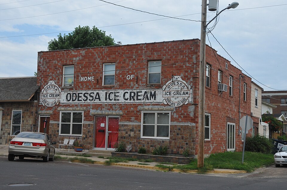
Photograph of Odessa Ice Cream Company Building
Photograph by JERRYE AND ROY KLOTZ MD, CC BY-SA 3.0. Via Wikimedia Commons.

Odessa Ice Cream Company Building

Listed on the National Register of Historic Places in 1996.

From the record

“Odessa Ice Cream Company Building is a historic commercial building and ice cream factory located in Odessa, Lafayette County, Missouri. It was built in 1929, and is a two-story, three bay by five bay, clay block and brick building.”

Wikipedia article Odessa Ice Cream Company Building, CC BY-SA 4.0.

One of 32 National Register listings published here for Lafayette County · listed in 1996 · category: Building.

Sources: the Wikipedia article · the case file at the National Archives · the National Register database, National Park Service

The listing

  • What is counted as historic. The nomination lists 1 building as contributing to the listing.
  • Address. 101 W. Dryden St., Odessa, 64076
  • When was it listed? October 1996
  • Category. building
  • Township. Sni-A-Bar township
  • National Register reference number. 96001065 - the number the National Park Service assigned this property when it was listed, and the key its nomination file is catalogued under at the National Archives.

What happened here

An account from the chapter on Sni-A-Bar township. The inset identifies its exact source book and publication year.

From History of Lafayette County, Mo. , Carefully Written and Compiled from the Most Authentic Official and Private Sources, Including a History of Its Townships, Cities, Towns, and Villages, Together with a Condensed History of Missouri; the Constitution of the United States, and State of Missouri; a Military Record of Volunteers in Either Army of the Great Civil War .., published 1881 - Sni-A-Bar Township

Deeds Of Violence

The following is given by Mr. Eli Adams: In the spring of 1841, Mrs. Mary Scott and her son, King B. Scott, were murdered in this township. Mrs. Scott's body was found in the fire in the house. In the spring of 1843, two years afterward, the body of King B. Scott was found in a branch of the Sni. Suspicion rested upon John C.

Read the rest of this passage

The ground it stands on

15,129 words

The chapter on Sni-A-Bar Township in History of Lafayette County, Mo. , Carefully Written and Compiled from the Most Authentic Official and Private Sources, Including a History of Its Townships, Cities, Towns, and Villages, Together with a Condensed History of Missouri; the Constitution of the United States, and State of Missouri; a Military Record of Volunteers in Either Army of the Great Civil War .., published 1881 names Odessa. This is what it says, exactly as the scans read.

The Hopewell O. S. Presbyterian Church, at Odessa, was organized September 14, 1850. The original members were: John H. Allison, Eliza Bledsoe, Sarah Bullard, C. D. Copp, S. S. Cornwell, Nancy Davidson, John Jackson, Clarinda Jackson, James M. Keith, Thomas Lee, Mary Lee, Elizabeth Lee, Ann Mary Lee, Elizabeth Keith, Nathaniel C. and Rebecca Maxwell, Mary M. Chesney,Jane Patterson, John B. and Adaline Taylor, H. and Lena Young.

Passage source: History of Lafayette County, Mo. , Carefully Written and Compiled from the Most Authentic Official and Private Sources, Including a History of Its Townships, Cities, Towns, and Villages, Together with a Condensed History of Missouri; the Constitution of the United States, and State of Missouri; a Military Record of Volunteers in Either Army of the Great Civil War .., published 1881.

Odessa Baptist Church, originally Mt. Hope church, changed August, 1879. It was organized August 25, 1874. Original members: Ann Bird, Hannah Barker, J. B., Nancy, M. E., Thomas W., and Rev. James L. Carmichael; Winifred Burns, Virgil, Samantha, r.nd Mattie E. Halsell, Viola Hatch, Richard Y. Nichelsen, Milton, Mary, Ida B., and Dora M. Smith; Mary J. Starr, Lucinda McClure, Geo. W., and Elizabeth Wheeler. The chnrch is frame and was built in 1878, at a cost of $1,450. The church was dedicated August 29, 1880, by the late Rev. Isaac N. Newman. Their pastors have been: Geo. W. Smith, 1874; D. C. Bolton, 1875; J. B. Jackson, 1876; I. N. Newman, 1877; Henry Barton, a short time in 1878; J as. L. Carmichael, 1878; L. Ellege, 1879; Alex. Barton, 1879; W. T. Russell, 1881, the present pastor. Present members number eigty-seven. Revs. Newman and Barton were supplies only for a short timt each. The regular Baptists own a one-fourth interest in the building. Milton Smith, T, W. Carmichael, Thos. W. Gott, trustees, Thomas W. Carmichael, clerk. They have an interesting Sunday-school, organized in April, 1880; Thomas W. Carmichael, superintendant.

Passage source: History of Lafayette County, Mo. , Carefully Written and Compiled from the Most Authentic Official and Private Sources, Including a History of Its Townships, Cities, Towns, and Villages, Together with a Condensed History of Missouri; the Constitution of the United States, and State of Missouri; a Military Record of Volunteers in Either Army of the Great Civil War .., published 1881.

Machine-read from a century-old scan, so expect the errors a machine makes: misspelled names, dropped words, stray characters.

Read the whole chapter on Sni-A-Bar Township - 15,129 words on its settlement, mills, schools and churches.

Fires near this property

7 since 2005

Regional context, not property-specific evidence. The federal wildfire occurrence database lists 7 fires within 5 miles of Odessa Ice Cream Company Building between 2005 and 2019, burning about 72 acres in total. None started naturally. 1 was recorded as arson. Distance is straight-line from the map coordinates, so a fire counted here may appear on a neighbouring settlement's page as well.

Reported cause Fires
Missing data/not specified/undetermined4
Equipment and vehicle use1
Recreation and ceremony1
Arson/incendiarism1

The most recent of them, most recent first, with the day each was reported and the service that recorded it.

DateCause SizeReported by Name on the report
6 June 2006Equipment and vehicle useunder an acreMissouri State Fire Marshal's Officenot named
7 April 2018Missing data/not specified/undeterminedunder an acreMissouri Department of Conservation176450-05441-04072018-1427
5 April 2006Arson/incendiarism1.0 acresMissouri State Fire Marshal's Officenot named
2 April 2005Recreation and ceremony10 acresMissouri State Fire Marshal's Officenot named
29 March 2005Missing data/not specified/undetermined60 acresMissouri State Fire Marshal's Officenot named
10 March 2019Missing data/not specified/undeterminedunder an acreMissouri Department of Conservation178276-05441-03102019-1323
22 October 2019Missing data/not specified/undeterminedunder an acreMissouri Department of Conservation179463-05441-10222019-1450

Every fire recorded in Lafayette County

Mines and quarries near this property

5 within 5 miles

Regional context, not property-specific evidence. The federal mineral resources record lists 5 workings within 5 miles of Odessa Ice Cream Company Building: 5 past producers. None of them still produces. What was taken out: Stone, Crushed/Broken. Distance is straight-line from the map coordinates, so a quarry counted here may appear on a neighbouring settlement's page as well.

Where SiteCommodity StatusRecorded
UnknownStone, Crushed/BrokenPast Producer

Every working recorded in Lafayette County

Storms near this property

50 since 1994

Regional context, not property-specific evidence. The National Weather Service names Odessa, the town this property stands in, in 50 storm reports between 1994 and 2025: 22 hail, 21 thunderstorm wind, 6 flash flood, 1 tornado. No death or injury is recorded in these reports. Each account below is quoted exactly as the forecast office filed it, from the NOAA Storm Events Database, and each date opens the federal record of that event.

WhenEvent Place namedHarm What the report says
May 2002Flash FloodOdessa$800,000Junction of highway 131 and county road FF closed due to high water.
August 2019Thunderstorm WindOdessa$5,000Damage to trees around a Sonic on Highway 131. Tree came down and took out some power lines.
April 2007Thunderstorm WindOdessa$5,000Construction trailer blown over on Highway 40. Also some power lines down.
August 2006Thunderstorm WindOdessa$2,000Power lines and several trees down.
June 2001Thunderstorm WindOdessa$2,000no account filed
June 2010Thunderstorm WindOdessa$1,000A tree was blown onto powerlines and caused a fire. Thunderstorm winds were estimated up to 60 mph.
May 2001Thunderstorm WindOdessa$1,000Thunderstorm winds destroyed a barn.
June 2025Thunderstorm WindOdessa-Delayed report of downed limbs and a couple of wires near Odessa.
July 2025Thunderstorm WindOdessa-Downed wires near Route WW east of Odessa.
March 2024HailOdessa-Quarter size hail in Odessa.
March 2024HailOdessa-Social media photo of ping pong ball sized hail in Lake Lafayette.
March 2024HailOdessa-Mping report of half dollar sized hail near Route M and Varner Road southeast of Odessa.
August 2019HailOdessa-Reported from Sonic Drive In.
July 2017Flash FloodOdessa-Interstate 70 was closed at mile marker 38 due to flash flooding.
July 2017Flash FloodOdessa-A citizen was rescued from the top of their car after it was swept into a ditch.
June 2017Thunderstorm WindOdessa-Several trees and power lines were down in Odessa.
April 2016HailOdessa-This report was received via Twitter.
April 2015HailOdessa-This report was gained via social media.
April 2015HailOdessa-This hail was precisely measured at 1 1/8 inches.
June 2015Flash FloodOdessa-Interstate 70 was flooded with 6 to 12 inches of water near mile marker 37 and 38.
June 2015Flash FloodOdessa-Water was covering the front porch and up to the door threshold at a residence in Odessa. There was substantial water running through the yard, and small livestock needed to be rescued from the rising water.
April 2014Tornado (EF0)Odessa-A brief tornado formed within a linear convective severe storm that moved through the Kansas City Metro area. As the storm approached Odessa, Missouri a weak and brief tornado caused some minor damage to businesses and residences in Odessa. The worst of the damage occurred across the west end of town, then the tornado crossed Interstate 70 causing a semi to overturn on the westbound lane of I-70 near Odessa.
July 2005Thunderstorm WindOdessa-Two trees blown down intersection of 131 and HH.
May 2004Thunderstorm WindOdessa-Large trees downed from thunderstorm winds.
May 2002Thunderstorm WindOdessa-Large tree limbs blown down.
April 2000Thunderstorm WindOdessa-Odessa Police reported 65 mph winds southeast of town.
October 2000Thunderstorm WindOdessa-The Odessa Police Department reported 60 mph wind gusts.
October 2000Thunderstorm WindOdessa-The sheriff's department reported 60 mph wind gusts at mile marker 47 on Interstate 70.
July 1998Flash FloodOdessa-Between 2 and 4 inches of rain fell over much of Lafayette County resulting in several reports of flash flooding. In Odessa, Highway U which is just east of Highway M, was under 2 feet of water for a half mile stretch.
June 1998Thunderstorm WindOdessa-The Odessa Fire Department reported 4 inch diameter tree limbs blown down in Odessa.
July 1994Thunderstorm WindOdessa-Several large trees were blown down.
May 2018HailOdessa-no account filed
April 2015HailOdessa-no account filed
May 2010HailOdessa-no account filed
February 2007HailOdessa-no account filed
April 2007HailOdessa-no account filed
September 2003HailOdessa-no account filed
September 2003Thunderstorm WindOdessa-no account filed
April 2003HailOdessa-no account filed
December 2002HailOdessa-no account filed
May 2002HailOdessa-no account filed
April 2001HailOdessa-no account filed
May 2001HailOdessa-no account filed
June 2001Thunderstorm WindOdessa-no account filed
June 1996Thunderstorm WindOdessa-no account filed
May 1995Thunderstorm WindOdessa-no account filed

Every storm recorded in Lafayette County

Map coverage status

No historic map-sheet match is published for this property yet. That does not mean no map exists. This record needs a coordinate-quality review before it can be joined to a sheet boundary. Browse the county's mapped places while that work is pending.

Sources for this property

National Archives recordThe nomination case file for reference 96001065 in Record Group 79.
Wikipedia articleCommunity-written account of this property, licensed CC BY-SA.
Lafayette CountyAll 32 listed properties in this county.

Provenance

  • Listing record. National Park Service National Register of Historic Places, listed-properties dataset, current to 2026-05-22.
  • Map join. Address geocoded through the United States Census geocoder, then tested against the published boundary of every sheet in the USGS Historical Topographic Map Collection.
  • How this page is made. Listing fields come from federal records; map-sheet coverage is a labelled coordinate-to-boundary calculation, not a source-field claim.
  • Wildfire. Short, Karen C. 2022. Spatial wildfire occurrence data for the United States, 1992-2020 [FPA_FOD_20221014]. 6th Edition. Fort Collins, CO: Forest Service Research Data Archive. https://doi.org/10.2737/RDS-2013-0009.6 Collected with United States Government funding and usable without additional permissions or fees.
  • Mines and quarries. USGS Mineral Resources Data System (MRDS) https://mrdata.usgs.gov/mrds/ A work of the United States government, no copyright under 17 U.S.C. 105.
  • Storms. NOAA National Centers for Environmental Information, Storm Events Database https://www.ncei.noaa.gov/stormevents/ A work of the United States government, no copyright under 17 U.S.C. 105. Narratives are quoted verbatim from the National Weather Service report and are not edited or summarised.