BlockBefore

Lafayette County, Missouri

103 topographic sheets cover 27 settlements here, and 32 properties are on the National Register of Historic Places.

Research this county

From the record

“He was shot in his yard by the bushwhackers, part of whom are said to have been Dave Poole's men, and part Todd's. The house was burned with its entire contents; Mrs. Prigmore and her sister-in-law, a cripple, escaping with nothing but the clothes they wore.”

Murder Of Judge Wm. Prigmore - History of Lafayette County, Mo. , Carefully Written and Compiled from the Most Authentic Official and Private Sources, Including a History of Its Townships, Cities, Towns, and Villages, Together with a Condensed History of Missouri; the Constitution of the United States, and State of Missouri; a Military Record of Volunteers in Either Army of the Great Civil War .. (1881). Machine-read text.

32 National Register listings published here · the county-history sources tell 14 stories and name 294 people · people the book names include Mrs. Lou Abney (Davis Township, 1881) · Noah P. Adams (Sni-A-Bar Township, 1881) (machine-read).

Sources: the county history on the Internet Archive · the National Register database, National Park Service

Missouri within the United States
Lafayette County within Missouri

What the record shows

  • 469 topographic sheet readings cover the county's settlements.
  • 32 properties here are on the National Register of Historic Places: 25 buildings, 5 districts and 2 sites.
  • 4 of the 32 listings were added during the 1970s.
  • The Geographic Names Information System records 27 populated places in this county; 27 are covered by at least one topographic sheet.
  • 2 public-domain county histories, 1881 and 1910, supply 162,980 words of narrative reproduced here.

What happened here

14 accounts

Among them: Bushwhacking And Bank Robbery; Dark Deeds; James H. Hannah. These passages come from the identified county-history source books. Each inset names its own source and opens the exact section it comes from.

From Young's History of Lafayette County, Missouri, published 1910 - Freedom Township

Bushwhacking And Bank Robbery

In 1863, during the Civil war strife, a party of thirty-five bushwhackers came across Davis creek to where Concordia now stands and killed Lewis Fiene, William Schornhorst, D. Karston and Conrad Bruns. They were made to stand up in a row, and when the shooting at them commenced some started to run, but all were finally killed.

Read the rest of this passage

From History of Lafayette County, Mo. , Carefully Written and Compiled from the Most Authentic Official and Private Sources, Including a History of Its Townships, Cities, Towns, and Villages, Together with a Condensed History of Missouri; the Constitution of the United States, and State of Missouri; a Military Record of Volunteers in Either Army of the Great Civil War .., published 1881 - Clay Township

Dark Deeds

Among the incidents worthy of here being recorded are the following: During the Civil war days James Johnson, who lived at Bates City, was killed by a band of "Kansas Jayhawkers," supposed to have been at the instigation of a negro, whom he had once whipped while acting as constable in his township. The act was forced upon him by law, but the dire spirit of revenge upon the part of the black man caused him to call upon these troops, who took Mr.

Read the rest of this passage

From History of Lafayette County, Mo. , Carefully Written and Compiled from the Most Authentic Official and Private Sources, Including a History of Its Townships, Cities, Towns, and Villages, Together with a Condensed History of Missouri; the Constitution of the United States, and State of Missouri; a Military Record of Volunteers in Either Army of the Great Civil War .., published 1881 - Clay Township

James H. Hannah

P. O. Greenton, Missouri; was born in Jefferson county, Virginia, and there raised and educated. In 1855 he came to Missouri, and settled in Saline county, where he lived several years. During the war he moved to this county, where he has since lived, engaged in farming. In 1861 he enlisted in the southern army, and was in the battles of Coon's Creek, and in all the battles of Price's retreat from the state, and captured near Cane Hill, and kept prisoner a short time.

Read the rest of this passage

From History of Lafayette County, Mo. , Carefully Written and Compiled from the Most Authentic Official and Private Sources, Including a History of Its Townships, Cities, Towns, and Villages, Together with a Condensed History of Missouri; the Constitution of the United States, and State of Missouri; a Military Record of Volunteers in Either Army of the Great Civil War .., published 1881 - Sni-A-Bar Township

Deeds Of Violence

The following is given by Mr. Eli Adams: In the spring of 1841, Mrs. Mary Scott and her son, King B. Scott, were murdered in this township. Mrs. Scott's body was found in the fire in the house. In the spring of 1843, two years afterward, the body of King B. Scott was found in a branch of the Sni. Suspicion rested upon John C.

Read the rest of this passage

From History of Lafayette County, Mo. , Carefully Written and Compiled from the Most Authentic Official and Private Sources, Including a History of Its Townships, Cities, Towns, and Villages, Together with a Condensed History of Missouri; the Constitution of the United States, and State of Missouri; a Military Record of Volunteers in Either Army of the Great Civil War .., published 1881 - Sni-A-Bar Township

James P. Proctor

P. O. Odessa. Son of Thomas and Polly Proctor. Was born in Kentucky, and came with his parents to this state in 1838. In 1867 he married Mrs. Rachel Helm, widow of James Helm and daughter of Charles Glover. In 1861 he enlisted under Gen Shelby in the confederate army, and fought in several battles. Was captured near Lexington, and confind until the end of the war.

Read the rest of this passage

From History of Lafayette County, Mo. , Carefully Written and Compiled from the Most Authentic Official and Private Sources, Including a History of Its Townships, Cities, Towns, and Villages, Together with a Condensed History of Missouri; the Constitution of the United States, and State of Missouri; a Military Record of Volunteers in Either Army of the Great Civil War .., published 1881 - Sni-A-Bar Township

Noah P. Adams

P. O. Odessa. Was born in this county in 1844, and was married to Miss Mary E. Muir, December 1, 1870. In 1861 he enlisted in the Missouri state guard, then in the confederate army and served to the end of the war. Was in the battles of Lexington, Lone Jack, Westport, and Drywood, where he was captured and confined at Rock Island to the close of war.

Read the rest of this passage

From History of Lafayette County, Mo. , Carefully Written and Compiled from the Most Authentic Official and Private Sources, Including a History of Its Townships, Cities, Towns, and Villages, Together with a Condensed History of Missouri; the Constitution of the United States, and State of Missouri; a Military Record of Volunteers in Either Army of the Great Civil War .., published 1881 - Washington Township

Wm. T. Gammon

The subject of the following sketch is a native of Pocahontas county, W. Va.; born August 6, 1826. Was raised and educated there. In 1861 he enlisted in the confederate army, joining the 25th Virginia Regiment. Was elected captain of his company. At the battle of Cross Keys, June 8, 1862, he was severely wounded, and failing to improve where he was, he went to Georgia for the purpose of recruiting his health.

Read the rest of this passage

From History of Lafayette County, Mo. , Carefully Written and Compiled from the Most Authentic Official and Private Sources, Including a History of Its Townships, Cities, Towns, and Villages, Together with a Condensed History of Missouri; the Constitution of the United States, and State of Missouri; a Military Record of Volunteers in Either Army of the Great Civil War .., published 1881 - Davis Township

The Hospital Episode

The Federals had occupied as a hospital the then magnificent residence of Oliver Anderson, Esq., a two-and-a-half story brick building, down the slope about twenty rods west from the outer line of their intrenchments [See diagram,] and several hundred rods from the " Masonic College. " On top of this building there was a yellow flag displayed, marking it as a hospital, and in it were 24 sick and 96 wounded, according to Mulligan's report.

Read the rest of this passage

From History of Lafayette County, Mo. , Carefully Written and Compiled from the Most Authentic Official and Private Sources, Including a History of Its Townships, Cities, Towns, and Villages, Together with a Condensed History of Missouri; the Constitution of the United States, and State of Missouri; a Military Record of Volunteers in Either Army of the Great Civil War .., published 1881 - Davis Township

Fkdearl Operations

As soon as word was sent to Mulligan that the hospital had been captured, he ordered a German company, of Peabody's regiment, to retake it. This company, Mulligan says, refused to go outside of the breastwork, saying: "We shall go not out, for it is bad to go out!" A company of White's home guards was then ordered to "go out," but it would "go not out." "Then," Mulligan says, "the Montgomery guards, Capt.

Read the rest of this passage

From History of Lafayette County, Mo. , Carefully Written and Compiled from the Most Authentic Official and Private Sources, Including a History of Its Townships, Cities, Towns, and Villages, Together with a Condensed History of Missouri; the Constitution of the United States, and State of Missouri; a Military Record of Volunteers in Either Army of the Great Civil War .., published 1881 - Davis Township

Battle Items

A careful reckoning of the killed and wounded mentioned in the official reports of nine different Confederate officers gives a total of 38 killed and 150 wounded.* This is supposed to have included only those who were enrolled as soldiers, and whose absences were thus accounted for at rollcall. The number of killed and wounded among the thousands who took part in this battle but were not enlisted soldiers, can never be ascertained; but there is no reason to doubt that the killed and wounded among this class were quite as many as among the enrolled men.

Read the rest of this passage

From History of Lafayette County, Mo. , Carefully Written and Compiled from the Most Authentic Official and Private Sources, Including a History of Its Townships, Cities, Towns, and Villages, Together with a Condensed History of Missouri; the Constitution of the United States, and State of Missouri; a Military Record of Volunteers in Either Army of the Great Civil War .., published 1881 - Davis Township

History Of Lafayette Count V.

(See article headed " Lafayette Men's First Battle.") The other one was an iron six-pounder, one of the two that had been cast at Morrison's foundry. A brass six-pounder from Independence was afterwards added to the battery. But during the course of the war Bledsoe's battery lost, captured, exploded and wore out guns, so that first and last it had in use every kind of gun known to modern artillery service - howitzers, parrotts, Rodmans, Napoleons, - brass, iron, steel amalgum ; rifled and smoothe bores.

Read the rest of this passage

From History of Lafayette County, Mo. , Carefully Written and Compiled from the Most Authentic Official and Private Sources, Including a History of Its Townships, Cities, Towns, and Villages, Together with a Condensed History of Missouri; the Constitution of the United States, and State of Missouri; a Military Record of Volunteers in Either Army of the Great Civil War .., published 1881 - Davis Township

Deeds Of Violence

A federal paymaster having in his possession $55,000, which he was transporting to Marshall, Saline county, with a guard of 25 men, commanded by Capt. Perry, had stopped at the residence of Alfred P. Lewis, " for the purpose of remaining overnight. While there they were attacked by a company of bushwhackers, led by Dave Blount, who captured the vehicle which contained the money, securely locked up in a strong box, and its guard of three pickets.

Read the rest of this passage

From History of Lafayette County, Mo. , Carefully Written and Compiled from the Most Authentic Official and Private Sources, Including a History of Its Townships, Cities, Towns, and Villages, Together with a Condensed History of Missouri; the Constitution of the United States, and State of Missouri; a Military Record of Volunteers in Either Army of the Great Civil War .., published 1881 - Davis Township

Murder Of Judge Wm. Prigmore

This murder occurred October 10, 1864. He was shot in his yard by the bushwhackers, part of whom are said to have been Dave Poole's men, and part Todd's. The house was burned with its entire contents; Mrs. Prigmore and her sister-in-law, a cripple, escaping with nothing but the clothes they wore.

Read the rest of this passage

From History of Lafayette County, Mo. , Carefully Written and Compiled from the Most Authentic Official and Private Sources, Including a History of Its Townships, Cities, Towns, and Villages, Together with a Condensed History of Missouri; the Constitution of the United States, and State of Missouri; a Military Record of Volunteers in Either Army of the Great Civil War .., published 1881 - Davis Township

Harrison Luttrell

P. O., Aullville, Mo., son of Richard and Polly Luttrell. Was born Feb. 3, 1835, in Clinton county, Ohio, where he was raised and educated. He continued on his father's farm until 1861, when he enlisted in the union army uuder Gen. Sherman, Co., D, 48th Ohio regiment, and was in the army three years. He was wounded once, in the shoulder by a minnie ball, at Arkansas Post; was discharged at Indianapolis, and returned home.

Read the rest of this passage

Places on the National Register

32

Every property in this county listed on the National Register of Historic Places, with the year it was listed and the federal nomination document.

Photograph PropertyType ListedReference
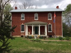
Anderson House and Lexington Battlefieldsite196969000110
Napoleon Buck Housebuilding199797001431
Minatree Catron Housebuilding199797001432
John E. Cheatham Housebuilding199393000550
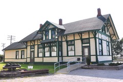
Chicago and Alton Railroad Depot at Higginsvillebuilding198787000451
Commercial Community Historic Districtdistrict198383001025
Confederate Chapel, Cemetery and Cottagebuilding198181000335
Cumberland Presbyterian Churchbuilding197878001665
James M. Dinwiddie Housebuilding199797001430
Douglass Schoolbuilding2023100008715
Forest Grove Cemeterysite2022100007905
Theodore Gosewisch Housebuilding199797001433
Alexander and Elizabeth Aull Graves Housebuilding199393000552
Hicklin Hearthstonebuilding198282000585
Hicklin Schoolbuilding200404000088
Highland Avenue Historic Districtdistrict198383001026
House at 1413 Lafayette St.building199999000379
Houx-Hoefer-Rehkop Housebuilding198383001027
David John Housebuilding199393000553
George Johnson Housebuilding199393000554
Lafayette County Courthousebuilding197070000339
Linwood Lawnbuilding197373001044
Machpelah Cemeterydistrict2022100007825
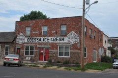
Odessa Ice Cream Company Buildingbuilding199696001065
Old Neighborhoods Historic Districtdistrict198383001028
Robinson, William, P., Housebuilding199797001428
Thomas Shelby Housebuilding199797001429
Spratt-Allen-Aull Housebuilding199393000555
Thomas Talbot and Rebecca Walton Smithers Stramcke Housebuilding199999001208
D. W. B. and Julia Waddell Tevis Housebuilding199393000556
Waddell Housebuilding197979001378
Wentworth Military Academydistrict198080002373

Wildfire, 1992 to 2020

74 fires

Every wildfire the federal occurrence database records inside this county: 74 of them, burning about 559 acres. None started naturally and 1 was recorded as arson. Each settlement page carries the fires within five miles of it.

Reported cause Fires
Missing data/not specified/undetermined42
Debris and open burning21
Equipment and vehicle use8
Recreation and ceremony1
Arson/incendiarism1
Smoking1

The five largest, by the area the report gives. None of them was recorded as arson.

DateCause SizeReported by Name on the report
24 January 2014Missing data/not specified/undetermined100 acresMissouri Department of Conservationnot named
30 January 2014Missing data/not specified/undetermined70 acresMissouri Department of Conservationnot named
29 March 2005Missing data/not specified/undetermined60 acresMissouri State Fire Marshal's Officenot named
8 April 2019Missing data/not specified/undetermined59 acresMissouri Department of Conservation178627-05438-04082019-2253
26 March 1992Debris and open burning50 acresMissouri Department of Conservationnot named
10 April 2014Missing data/not specified/undetermined45 acresMissouri Department of Conservationnot named
17 October 2020Equipment and vehicle use40 acresMissouri Department of Conservation251180-05438-10172020-1312
10 January 2018Debris and open burning19 acresMissouri Department of Conservation177732-05440-01102018-1929

Every settlement page carries the fires within five miles of it - see the settlement index below.

Storms, 1958 to 2025

60 of 392 shown

The NOAA Storm Events Database holds 392 reports for this county, causing 1 death, 5 injuries and about $5,104,560 in recorded property damage. Each settlement page carries the reports that name it.

Kind of event Reports
Thunderstorm Wind159
Hail157
Tornado29
Flash Flood24
Flood20
Funnel Cloud3

The most serious of them, by death, then injury, then recorded damage. The accounts are quoted exactly as the forecast office filed them.

WhenEvent Place namedHarm What the report says
May 1977Tornado (F3)not stated1 killed, 5 hurt, $2,500,000no account filed
May 2002Flash FloodOdessa$800,000Junction of highway 131 and county road FF closed due to high water.
May 2003Tornado (F2)Corder$500,000Tornado reported near Corder and tracked northeast into Saline county. destoyed a machine shed, house with grain bins damaged along with a dairy barn.
March 2006HailEmma$300,000Large hail damaged many automobiles and homes.
June 1960Tornado (F1)not stated$250,000no account filed
June 1958Tornado (F2)not stated$250,000no account filed
May 2000Tornado (F1)Lexington$75,000A tornado, witnessed by two citizens, destroyed several outbuildings and damaged the roof of an earth-contact home 7 miles southeast of Lexington, MO.
June 1998Thunderstorm WindWellington$75,000Severe thunderstorm winds snapped 3 large trees at their bases and flattened a gazebo in Wellington. Also in Wellington, a porch which was still intact blew on top of the roof of a trailer. Power lines and numerous trees were blown down in Lexington. In Waverly, several trees 12 to 24 inches in diameter were blown down. Numerous power outages were reported in Odessa as a result of the thunderstorms.
June 2000Thunderstorm WindLexington$25,000Trees and power lines were downed along Highway 224 just west of Lexington. An empty boxcar was knocked off a nearby railroad track.
August 1999FloodConcordia$25,000High water covered State Highway 23 in Concordia. Newspaper accounts indicate that gravel was washed from some streets in and near Concordia, and the blacktop was ripped off of part of another street.
May 1999Thunderstorm WindCorder$25,000A mobile home was destroyed in Corder.
May 1995Tornado (F0)Higginsville$25,000A severe thunderstorm dropped up to golfball size hail on Bates City, and then went on to develop 2 weak tornadoes. The first tornado touched down south of Bates City at 1820 CST and was crossing Interstate 70 3 miles west of Odessa at 1831 CST. Only minor tree damage was reported. It then lifted north of Odessa. A second touchdown occurred about 5 miles northwest of Higginsville at 1845 CST. The track took it across State Route 13 5 miles northwest of Higginsville near the Tabo Creek bridge at 1900 CST. At 1905 CST, the tornado crossed Route 213 3 miles southwest of Dover, and then lifted 1 mile southwest of Dover at 1906 CST. A house along state Route 13, 6 miles southeast of the junction with Route E, had shingles removed from the roof as the funnel apparently lifted as it passed overhead. Eyewitnesses reported that the tornado bounced up and down as it continued on a path about 4.5 miles to the east-northeast. The damage path varied from about 30 to 40 yards wide, with most of the path over cultivated farm fields. Most damage was minimal, but the most significant damage occurred at the Humfeldt farm 2.6 miles south of U.S. Route 24 along state Route 213. A corrugated steel equipment building was destroyed when the south and west walls were blown in, and the roof was partially peeled off. There was only minor damage to the equipment inside. The tornado passed to the south of the house and garage, missing them by 25 feet. Only one shutter was blown off of the upper floor of the house with no other damage. Mud was splattered on all four sides of both the house and garage. The tornado was photographed as it was dissipating, in its rope stage between 1901 and 1906 CST. In addition, tree damage occurred in Corder with the gust front ahead of the parent thunderstorm.
March 2006HailConcordia$25,000no account filed
May 1968Tornado (F1)not stated$25,000no account filed
June 1958Tornado (F1)not stated$25,000no account filed
July 2020Thunderstorm WindMyrick$20,000A tree was on a vehicle near Wellington on HWY 224.
June 1995Thunderstorm WindLexington$12,000Severe thunderstorm winds blew a tree into a house in Lexington.
May 2000Thunderstorm WindDover$10,000Power lines were downed near Dover.
May 2000Thunderstorm WindAlma$10,000Power lines were downed near Alma.
June 2000Tornado (F0)Lexington$10,000A law enforcement officer reported that the tornado touched down just southeast of Lexington and moved east for 1 mile. Trees and power lines were downed.
July 2000Thunderstorm WindMayview$10,000Storm spotters reported downed trees and power lines, and damage to a roof.
June 1998Thunderstorm WindConcordia$10,000Severe thunderstorm winds blew a large tree onto the roof of a house in Concordia.
May 1996Thunderstorm WindBates City$7,000no account filed
August 2019Thunderstorm WindOdessa$5,000Damage to trees around a Sonic on Highway 131. Tree came down and took out some power lines.
April 2007Thunderstorm WindOdessa$5,000Construction trailer blown over on Highway 40. Also some power lines down.
April 2002Thunderstorm WindAlma$5,000Poles and power lines down.
May 2002Thunderstorm WindHigginsville$5,000Roof blown off car wash.
September 1995Thunderstorm WindBates City$5,000A strong thunderstorm over western Lafayette County knocked down trees and power lines. In Bates City, a barn was destroyed and there was minor damage to some homes.
May 1995Thunderstorm WindBates City$5,000Numerous trees were downed near Z and TT highways, 2 to 3 miles south of Bates city, partially blocking the roads.
September 1993Thunderstorm WindHigginsville$5,000Large trees were uprooted and dime-size hail fell.
September 1995Thunderstorm WindWaverly$4,000A severe thunderstorm moved through Northeast Lafayette County. Trees and power lines were reported down in Waverly as winds gusted to 70 MPH.
May 1995Tornado (F0)Bates City -$3,000A severe thunderstorm dropped up to golfball size hail on Bates City, and then went on to develop 2 weak tornadoes. The first tornado touched down south of Bates City at 1820 CST and was crossing Interstate 70 3 miles west of Odessa at 1831 CST. Only minor tree damage was reported. It then lifted north of Odessa. A second touchdown occurred about 5 miles northwest of Higginsville at 1845 CST. The track took it across State Route 13 5 miles northwest of Higginsville near the Tabo Creek bridge at 1900 CST. At 1905 CST, the tornado crossed Route 213 3 miles southwest of Dover, and then lifted 1 mile southwest of Dover at 1906 CST. A house along state Route 13, 6 miles southeast of the junction with Route E, had shingles removed from the roof as the funnel apparently lifted as it passed overhead. Eyewitnesses reported that the tornado bounced up and down as it continued on a path about 4.5 miles to the east-northeast. The damage path varied from about 30 to 40 yards wide, with most of the path over cultivated farm fields. Most damage was minimal, but the most significant damage occurred at the Humfeldt farm 2.6 miles south of U.S. Route 24 along state Route 213. A corrugated steel equipment building was destroyed when the south and west walls were blown in, and the roof was partially peeled off. There was only minor damage to the equipment inside. The tornado passed to the south of the house and garage, missing them by 25 feet. Only one shutter was blown off of the upper floor of the house with no other damage. Mud was splattered on all four sides of both the house and garage. The tornado was photographed as it was dissipating, in its rope stage between 1901 and 1906 CST. In addition, tree damage occurred in Corder with the gust front ahead of the parent thunderstorm.
May 2011Tornado (EF0)Waverly$2,500At 1458CST an EF0 tornado touched down in Waverly. The tornado moved about a tenth of a mile to the east, and lifted at 1503CST. A small portion of a mobile home roof was removed. A small garden shed was damaged. Minor tree damage was reported.
May 1973Tornado (F2)not stated$2,500no account filed
September 1965Tornado (F2)not stated$2,500no account filed
July 2010Thunderstorm WindAullville$2,000Thunderstorm wind gusts were estimated up to 70 mph. Trees and power poles were reported down, along with many tree limbs.
June 2009Thunderstorm WindHigginsville Jct Arp$2,000Power lines were reported down.
October 2007Thunderstorm WindConcordia$2,000The roof of a loafing shed was ripped from a barn. Also a 2x4 board pierced the wall of the garage.
August 2006Thunderstorm WindOdessa$2,000Power lines and several trees down.
June 2001Thunderstorm WindOdessa$2,000no account filed
June 2010Thunderstorm WindOdessa$1,000A tree was blown onto powerlines and caused a fire. Thunderstorm winds were estimated up to 60 mph.
June 2005Thunderstorm WindWaverly$1,000Tree limbs and power lines down.
June 2005Thunderstorm WindCorder$1,000Power lines and tree limbs down.
May 2001Thunderstorm WindOdessa$1,000Thunderstorm winds destroyed a barn.
July 2013Tornado (EF0)Waverly$750An EF0 tornado or landspout touched down briefly at 1650CST, three miles southeast of Waverly. The tornado was stationary and lifted or dissipated at 1651CST. Tree damage was observed, along with shingle damage to the roof of a residence.
May 2011Tornado (EF0)Lexington$500At 1338CST a brief EF0 tornado touched down 1 mile east of Lexington, and moved east about a third of a mile, before lifting at 1340CST. Law enforcement reported that one outbuilding was destroyed.
June 2008Tornado (EF0)Alma$500A brief EF0 tornado touched down at 2323CST and moved northeast, before lifting at 2325CST. The only damage outside of broken tree limbs, was to a porch at a residence just south of Alma.
April 1982Tornado (F1)not stated$250no account filed
April 1967Tornado (F0)not stated$30no account filed
June 1967Tornado (F0)not stated$30no account filed
May 2025Thunderstorm WindWellington-Downed tree on Route 131 near Route FF.
March 2025Thunderstorm WindNapoleon-Downed wires near Old Santa Fe Trail.
June 2025Thunderstorm WindPage City-Large tree uprooted and split. Cornfield debris strewn across property. Heavy fire pit lifted and moved 10 feet. Metal framing twisted and bent. Metal chairs lifted and moved.
June 2025Thunderstorm WindLexington-Downed tree limbs in the Lexington area.
June 2025Thunderstorm WindOdessa-Delayed report of downed limbs and a couple of wires near Odessa.
June 2025Thunderstorm WindPage City-Downed tree limbs near U.S. Highway 24 east of Lexington.
July 2025Thunderstorm WindBates City-Downed wires and several power outages in the Bates City area.
July 2025Thunderstorm WindOdessa-Downed wires near Route WW east of Odessa.
July 2025Thunderstorm WindHigginsville Jct Arp-Downed wires near Maple Leaf Lake Conservation Area south of Higginsville.

Mines and quarries

44 recorded

The Survey's mineral resources record lists 44 workings inside this county. 2 still produce and 42 are closed or unrecorded. Each settlement page carries the workings within five miles of it.

Commodity Workings
Stone, Crushed/Broken41
Coal3
Stone, Dimension2
Sand and Gravel, Construction1

The least common of them first, because a county's hundredth gravel pit says nothing its first ten did not.

Where SiteCommodity StatusRecorded
Drivers DredgeSand and Gravel, ConstructionProducer
Breuer QsuarryStone, DimensionPast Producer
Walter Boles QuarryStone, DimensionPast Producer
Craddy MineStone, Crushed/Broken, CoalPast Producer
UnknownStone, Crushed/Broken, CoalPast Producer
Chapel Hill QuarryStone, Crushed/BrokenPast Producer
Covenant EnterprisesStone, Crushed/BrokenProducer
Hoefer QsuarryStone, Crushed/BrokenPast Producer
Horstman QuarryStone, Crushed/BrokenPast Producer
Hulver QuarryStone, Crushed/BrokenPast Producer
Jim Thurman QuarryStone, Crushed/BrokenPast Producer
Lexington QuarryStone, Crushed/BrokenPast Producer
Macedonia SquarryStone, Crushed/BrokenPast Producer
Mitchell QsuarryStone, Crushed/BrokenPast Producer
Prock QuarryStone, Crushed/BrokenPast Producer
UnknownStone, Crushed/BrokenPast Producer

The townships, in 1910

162,980 words

Young's History of Lafayette County, Missouri devotes a chapter to each township: its boundaries and streams, who settled it and when, the mills, the schools and the churches. All 8 are reproduced here in full. Each row shows the township's own shape and where it lies in the county, drawn from the Census Bureau's boundary. Which settlements belong to which township is computed from that same boundary, not taken from the book.

The county's history books

411,695 words

2 books written about this county, cut here where the book itself is cut, at its printed chapters: 22 chapters in all. Every chapter is public domain, machine-read from the scan and reproduced complete. A chapter already given under one of the county's towns is not repeated in this list.

History of Lafayette County, Mo. , Carefully Written and Compiled from the Most Authentic Official and Private Sources, Including a History of Its Townships, Cities, Towns, and Villages, Together with a Condensed History of Missouri; the Constitution of the United States, and State of Missouri; a Military Record of Volunteers in Either Army of the Great Civil War .. (1881)

ChapterLength
The whole text289,291 words in 19 parts

Young's History of Lafayette County, Missouri (1910)

The people it describes

294 named

Everyone Young's History of Lafayette County, Missouri stops to write about, with the section that describes them. Among them are the men who founded the place and governed the Territory. Each name opens the passage itself, in the words of 1910.

Every populated place in the county

27

Named settlements recorded in the Geographic Names Information System, each with the topographic sheets covering it. Villages, hamlets and abandoned places alike. Each is shown with the nearest named watercourse or landform and the survey quadrangle it falls on.

The vanished settlements of Lafayette County: the places named above that are no longer on the map.

Provenance

  • Topographic sheets. USGS Historical Topographic Map Collection, county index, measured from the bulk metadata.
  • Fire insurance maps. Library of Congress Sanborn collection, faceted to this county.
  • Photographs. Each place queried individually against the Library of Congress Prints and Photographs search.
  • Wildfire. Short, Karen C. 2022. Spatial wildfire occurrence data for the United States, 1992-2020 [FPA_FOD_20221014]. 6th Edition. Fort Collins, CO: Forest Service Research Data Archive. https://doi.org/10.2737/RDS-2013-0009.6 Collected with United States Government funding and usable without additional permissions or fees.
  • Mines and quarries. USGS Mineral Resources Data System (MRDS) https://mrdata.usgs.gov/mrds/ A work of the United States government, no copyright under 17 U.S.C. 105.
  • Storms. NOAA National Centers for Environmental Information, Storm Events Database https://www.ncei.noaa.gov/stormevents/ A work of the United States government, no copyright under 17 U.S.C. 105. Narratives are quoted verbatim from the National Weather Service report and are not edited or summarised.