
BlockBefore
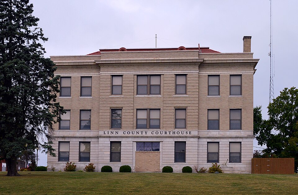
Photograph of Linn County Courthouse
Photograph by Kbh3rd, CC BY 4.0. Via Wikimedia Commons.

Linn County Courthouse

Listed on the National Register of Historic Places in 1999.

From the record

“The Linn County Courthouse is a historic courthouse at 108 High Street in Linneus, Missouri. It was built in 1912-1913 and is a three-story, cubic-form Beaux-Arts-style building constructed of concrete, stone and brick.”

Wikipedia article Linn County Courthouse (Missouri), CC BY-SA 4.0.

One of 9 National Register listings published here for Linn County · listed in 1999 · category: Building.

Sources: the Wikipedia article · the case file at the National Archives · the National Register database, National Park Service

The listing

  • What is counted as historic. The nomination lists 1 building as contributing to the listing.
  • Address. 108 High St., Linneus, 64653
  • When was it listed? October 1999
  • Category. building
  • Township. Locust Creek township
  • Architectural style. Beaux-Arts
  • National Register reference number. 99001254 - the number the National Park Service assigned this property when it was listed, and the key its nomination file is catalogued under at the National Archives.

What happened here

An account from the chapter on Locust Creek township. The inset identifies its exact source book and publication year.

From The History of Linn County, Missouri. An Encyclopedia of Useful Information, published 1882 - Locust Creek Township

The Nichols Tragedy

Oil the morning of Febrnarj 10, 1867, Sid Nichols, a man some fifty jears of age, with a good character for honesty, etc., living on a farm in the township, committed one of those horrible deeds of murder and self-destruction that sends a thrill of horror through the communitj^ in which it occurs. Mr.

Read the rest of this passage

The ground it stands on

42,547 words

The chapter on Locust Creek Township in The History of Linn County, Missouri. An Encyclopedia of Useful Information, published 1882 names Linneus. This is what it says, exactly as the scans read.

The township is now composed of about equal portions of prairie and timber, some very excellent varieties of the latter abounding. The general surface is level. East and northeast of Linneus lies the finest portion of the township. In the northern part, among " the white oaks," or on Bear Branch, and along Locust Creek are the most broken parts of the territory. The greatest extent of timber is along Locust Creek, but perhaps the most valuable is on Muddy and Turkej'' Creeks. On the latter streams there is excellent oak and walnut timber in abundance.

Passage source: The History of Linn County, Missouri. An Encyclopedia of Useful Information, published 1882.

A singular fact is to be recorded in this connection. When the township was first settled it was very difficult to find living water. Wells were dug to the depth of fifty feet or more without obtaining water. Especially in and around Linneus was this the case, and this state of affairs lasted for many years. Latterly this condition of things changed, and now Where once water could not be found, it gushes forth as readily and abundantly as it did from the rock at Horeb upon the smiting of the great Jewish lawgiver. Water-seers and well-wizards aver that the water is rising under all the surface of the earth in these parts.

Passage source: The History of Linn County, Missouri. An Encyclopedia of Useful Information, published 1882.

Machine-read from a century-old scan, so expect the errors a machine makes: misspelled names, dropped words, stray characters.

Read the whole chapter on Locust Creek Township - 42,547 words on its settlement, mills, schools and churches.

Fires near this property

7 since 1999

Regional context, not property-specific evidence. The federal wildfire occurrence database lists 7 fires within 5 miles of Linn County Courthouse between 1999 and 2018, burning about 103 acres in total. None started naturally. 2 were recorded as arson. Distance is straight-line from the map coordinates, so a fire counted here may appear on a neighbouring settlement's page as well.

Reported cause Fires
Debris and open burning3
Arson/incendiarism2
Missing data/not specified/undetermined2

The most recent of them, most recent first, with the day each was reported and the service that recorded it.

DateCause SizeReported by Name on the report
23 April 2018Missing data/not specified/undetermined16 acresMissouri Department of Conservation178028-05827-04232018-0445
23 April 2018Missing data/not specified/undetermined18 acresMissouri Department of Conservation176721-05827-04232018-0320
23 March 2002Debris and open burning1.0 acresMissouri Department of Conservationnot named
19 November 1999Debris and open burning4.0 acresMissouri Department of Conservationnot named
27 January 2002Arson/incendiarism3.0 acresMissouri Department of Conservationnot named
27 January 2002Arson/incendiarism1.0 acresMissouri Department of Conservationnot named
22 January 2002Debris and open burning60 acresMissouri Department of Conservationnot named

Every fire recorded in Linn County

Mines and quarries near this property

10 of 12 shown

Regional context, not property-specific evidence. The federal mineral resources record lists 12 workings within 5 miles of Linn County Courthouse: 12 past producers. None of them still produces. What was taken out: Stone, Crushed/Broken. Distance is straight-line from the map coordinates, so a quarry counted here may appear on a neighbouring settlement's page as well.

Where SiteCommodity StatusRecorded
Anderson QuarryStone, Crushed/BrokenPast Producer
Ben Parry QuarryStone, Crushed/BrokenPast Producer
Brinkley QuarryStone, Crushed/BrokenPast Producer
Singleton QuarryStone, Crushed/BrokenPast Producer
UnknownStone, Crushed/BrokenPast Producer

Every working recorded in Linn County

Storms near this property

21 since 1995

Regional context, not property-specific evidence. The National Weather Service names Linneus, the town this property stands in, in 21 storm reports between 1995 and 2023: 9 hail, 9 thunderstorm wind, 2 tornado, 1 flood. No death or injury is recorded in these reports. Each account below is quoted exactly as the forecast office filed it, from the NOAA Storm Events Database, and each date opens the federal record of that event.

WhenEvent Place namedHarm What the report says
February 2012Thunderstorm WindLinneus$50,000Thunderstorm straight line wind gusts were estimated from 80 to 100 mph. One residential building, just west of Highway 5, had its roof taken off. The residents were not home at the time. Many large trees were reported down, along with several barb wired fences.
July 1995TornadoLinneus$8,000The Missouri Highway Patrol reported a tornado on the ground north of Linneus. The landmark Little Red School House in Linn County was leveled.
May 2023Thunderstorm WindLinneus-About a mile to two miles south of the main tornado circulation widespread unidirectional wind damage occurred, likely as a result of a strong rear flank downdraft. This RFD wind was responsible for numerous damaged residences and outbuildings across Linn County.
May 2019FloodLinneus-Route B was closed in both directions near Linneus.
August 2010Thunderstorm WindLinneus-A tree was blown over with thunderstorm wind gusts estimated to 60 mph.
July 2007Thunderstorm WindLinneus-Thunderstorm wind gusts to 60 mph, caused 4 to 6 inch diameter tree branches to snap off on Route P.
May 2003Thunderstorm WindLinneus-Trees reported down by ham radio.
May 2003Tornado (F0)Linneus-Brief tornado touchdown in open country.
May 1998HailLinneus-A cooperative observer reported dime-size hail during a severe thunderstorm at Linneus.
June 2011HailLinneus-no account filed
July 2007HailLinneus-no account filed
May 2004HailLinneus-no account filed
May 2003Thunderstorm WindLinneus-no account filed
June 2001Thunderstorm WindLinneus-no account filed
February 2000HailLinneus-no account filed
June 1999HailLinneus-no account filed
May 1996HailLinneus-no account filed

Every storm recorded in Linn County

Map coverage status

No historic map-sheet match is published for this property yet. That does not mean no map exists. This record needs a coordinate-quality review before it can be joined to a sheet boundary. Browse the county's mapped places while that work is pending.

Listed places nearby

4 within 8 miles

Other National Register properties close enough to walk or drive between, ordered by distance from this one. Both positions come from the same geocoding pass that matched these properties to their map sheets.

Photograph PropertyDistance Listed
Linn County Jail and Sheriff's Residenceunder 500 feet2001
Plum Grove School4.6 miles1994
Gen. John J. Pershing Boyhood Home6.4 miles1969
Locust Creek Covered Bridge6.5 miles1970

Sources for this property

National Archives recordThe nomination case file for reference 99001254 in Record Group 79.
Wikipedia articleCommunity-written account of this property, licensed CC BY-SA.
Linn CountyAll 9 listed properties in this county.

Provenance

  • Listing record. National Park Service National Register of Historic Places, listed-properties dataset, current to 2026-05-22.
  • Map join. Address geocoded through the United States Census geocoder, then tested against the published boundary of every sheet in the USGS Historical Topographic Map Collection.
  • How this page is made. Listing fields come from federal records; map-sheet coverage is a labelled coordinate-to-boundary calculation, not a source-field claim.
  • Wildfire. Short, Karen C. 2022. Spatial wildfire occurrence data for the United States, 1992-2020 [FPA_FOD_20221014]. 6th Edition. Fort Collins, CO: Forest Service Research Data Archive. https://doi.org/10.2737/RDS-2013-0009.6 Collected with United States Government funding and usable without additional permissions or fees.
  • Mines and quarries. USGS Mineral Resources Data System (MRDS) https://mrdata.usgs.gov/mrds/ A work of the United States government, no copyright under 17 U.S.C. 105.
  • Storms. NOAA National Centers for Environmental Information, Storm Events Database https://www.ncei.noaa.gov/stormevents/ A work of the United States government, no copyright under 17 U.S.C. 105. Narratives are quoted verbatim from the National Weather Service report and are not edited or summarised.