BlockBefore

Linn County, Missouri

62 topographic sheets cover 29 settlements here, and 9 properties are on the National Register of Historic Places.

Research this county

From the record

“Sedgwick post-oflBce, section fifteen, township sixty, range eighteen, in this township, was established some years since, and named in honor of the Union general of that name who was killed in one of the battles of the Wilderness, in Yirginia, in the spring of 1864. Captain Seevey was the first postmaster.”

Post-Offices - The History of Linn County, Missouri. An Encyclopedia of Useful Information (1882). Machine-read text.

9 National Register listings published here, 1 of them a National Historic Landmark · the county-history sources tell 10 stories and name 159 people · people the book names include George Washington Adams (Jefferson Township, 1882) · John Seaman Alexander (Benton Township, 1882) (machine-read).

Sources: the county history on the Internet Archive · the National Register database, National Park Service

Missouri within the United States
Linn County within Missouri

What the record shows

  • 317 topographic sheet readings cover the county's settlements.
  • 9 properties here are on the National Register of Historic Places: 8 buildings and 1 structure.
  • 1 of them is a covered bridge.
  • 1 of the 9 listings was added during the 1970s.
  • The Geographic Names Information System records 29 populated places in this county; 29 are covered by at least one topographic sheet.
  • 2 public-domain county histories, 1882 and 1912, supply 150,766 words of narrative reproduced here.

What happened here

10 accounts

Among them: William F. Gibson; Crimes And Casualties; The Eighteenth Of June, 1864. These passages come from the identified county-history source books. Each inset names its own source and opens the exact section it comes from.

From The History of Linn County, Missouri. An Encyclopedia of Useful Information, published 1882 - Benton Township

William F. Gibson

was born in South Carolina, June 7, 1810. His parents were Thomas N. and Knth Gibson, who moved out to Tennessee at an early day. On the way ont, AVilliam F,, then a small boy, knocked a tomahawk out of a "kid" Indian's hand and brained him with it. It seems, however, that they arrived safe in Tennessee.

Read the rest of this passage

From The History of Linn County, Missouri. An Encyclopedia of Useful Information, published 1882 - Jefferson Township

Crimes And Casualties

As early as 1843 a very unfortunate accident happened near Myle's railb on Locust Creek. Two boys, one white, and bound to Dr. Dry den, the other a colored boy, a slave owned by the Doctor, went in swimming and were both drowned. They were not far from eighteen years of age. How it'happened is not known, unless taken with cramps.

Read the rest of this passage

From The History of Linn County, Missouri. An Encyclopedia of Useful Information, published 1882 - Jefferson Township

The Eighteenth Of June, 1864

One of the most exciting episodes which happened at Laclede was known as the Holtzclaw raid. Clifton Hotzclaw's father was killed by the Federals, it was claimed, for harboring the noted guerrilla chief. Bill Anderson. The senior Holtzclaw was undoubtedly a rebel sympathizer, but not an acactive participant.

Read the rest of this passage

From The History of Linn County, Missouri. An Encyclopedia of Useful Information, published 1882 - Jefferson Township

John F. Eoyd

Avas born on the Atlantic Ocean, on board the sliip Lagrange, August 20, 1840. When lie was about three jears old his parents were drowned at sea, the ship Lagrange being wrecked in the voyage from Liverpool to New York, April 14, 1843. John F. and his brother, only a babe, were saved. The subject of this sketch was reared by his uncle in Clermont county, Ohio.

Read the rest of this passage

From The History of Linn County, Missouri. An Encyclopedia of Useful Information, published 1882 - Jefferson Township

William Taylor

son of George and Rebecca {iiee Raymond) Taylor, was born in Sevier county, Tennessee, October 12, 1813. His father was a soldier of the War of 1812, and was wounded while in the service. The subject of this sketch grew to manhood in his native county, receiving but a limited education. Li 1833 he removed with his parents to Clay county, Missouri, and three years later came to Linn county, Missouri, being one of the pioneers of the county, and one among the very few of the early settlers now living.

Read the rest of this passage

From The History of Linn County, Missouri. An Encyclopedia of Useful Information, published 1882 - Jefferson Township

The First Steam Whistle

When the steam mill was just put up near St. Catharine, it was the first steam mill in Linn county. It is stated that when it first blew the whistle^ one evening, about dusk, the settlers on upper Yellow Creek concluded that the noise was the scream of a panther. They gathered together and many of them hunted for the monster all the next day.

Read the rest of this passage

From The History of Linn County, Missouri. An Encyclopedia of Useful Information, published 1882 - Jefferson Township

Murder Of Harrison Keady

In the month of July, 18G6, Harrison Keady was shot and killed by Charles Adkins on the road to St. Catharine, about one mile and a half from Bucklin. Keady was a farmer, who had not lived long in the township, and Charles Adkins had been in his employ. Adkins was a mere boy, only sixteen years of age. At the time of the murder Keady was driving an ox wagon, from which he was shot and instantly killed.

Read the rest of this passage

From The History of Linn County, Missouri. An Encyclopedia of Useful Information, published 1882 - Jefferson Township

Hiram Long

was born in Claremont, New Hampshire, in 1827, where he was reared and educated. His father was a native of Massachusetts, born in 1760, and his mother was a Yermonter by birth. They both died at an advanced age. The father had served in the Revolutionary War, and was several times captured by the British.

Read the rest of this passage

From The History of Linn County, Missouri. An Encyclopedia of Useful Information, published 1882 - Locust Creek Township

The Nichols Tragedy

Oil the morning of Febrnarj 10, 1867, Sid Nichols, a man some fifty jears of age, with a good character for honesty, etc., living on a farm in the township, committed one of those horrible deeds of murder and self-destruction that sends a thrill of horror through the communitj^ in which it occurs. Mr.

Read the rest of this passage

From The History of Linn County, Missouri. An Encyclopedia of Useful Information, published 1882 - North Salem Township

Post-Offices

Sedgwick post-oflBce, section fifteen, township sixty, range eighteen, in this township, was established some years since, and named in honor of the Union general of that name who was killed in one of the battles of the Wilderness, in Yirginia, in the spring of 1864. Captain Seevey was the first postmaster.

Read the rest of this passage

Places on the National Register

9

Every property in this county listed on the National Register of Historic Places, with the year it was listed and the federal nomination document.

Photograph PropertyType ListedReference
Christian Churchbuilding2025100011559
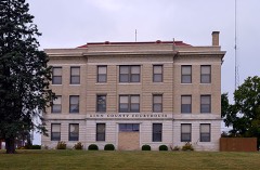
Linn County Courthousebuilding199999001254
Linn County Jail and Sheriff's Residencebuilding200100001659
Locust Creek Covered Bridgestructure197070000340
Marceline Masonic Lodge #481building2025100011561
Marceline Mercantile & Supply Companybuilding2025100011558
Gen. John J. Pershing Boyhood Homebuilding196969000111
Plum Grove Schoolbuilding199494001203
Uptown Theatrebuilding2023100009101

Covered bridges

1

Linn County has 1 covered bridge on the National Register. Each is a listed structure with a federal nomination on file.

Wildfire, 1992 to 2020

84 fires

Every wildfire the federal occurrence database records inside this county: 84 of them, burning about 2,086 acres. 2 started naturally and 4 were recorded as arson. Each settlement page carries the fires within five miles of it.

Reported cause Fires
Missing data/not specified/undetermined40
Debris and open burning30
Arson/incendiarism4
Recreation and ceremony3
Equipment and vehicle use3
Natural2
Power generation/transmission/distribution1
Misuse of fire by a minor1

The five largest, by the area the report gives. None of them was recorded as arson.

DateCause SizeReported by Name on the report
13 February 2006Missing data/not specified/undetermined350 acresMissouri State Fire Marshal's Officenot named
2 April 2005Debris and open burning300 acresMissouri State Fire Marshal's Officenot named
14 March 2018Missing data/not specified/undetermined264 acresMissouri Department of Conservation176720-05827-03142018-1500
14 January 2009Missing data/not specified/undetermined211 acresMissouri Department of ConservationRENO HOLLOW FIRE
7 February 1992Debris and open burning150 acresMissouri Department of Conservationnot named
15 March 2014Missing data/not specified/undetermined125 acresMissouri Department of Conservationnot named
22 March 2003Debris and open burning80 acresMissouri State Fire Marshal's Officenot named
18 March 2011Debris and open burning60 acresMissouri Department of Conservationnot named

Every settlement page carries the fires within five miles of it - see the settlement index below.

Storms, 1955 to 2025

60 of 252 shown

The NOAA Storm Events Database holds 252 reports for this county, causing no deaths, 16 injuries and about $5,397,030 in recorded property damage. Each settlement page carries the reports that name it.

Kind of event Reports
Thunderstorm Wind107
Hail102
Tornado19
Flash Flood18
Flood4
Heavy Rain1
Funnel Cloud1

The most serious of them, by death, then injury, then recorded damage. The accounts are quoted exactly as the forecast office filed them.

WhenEvent Place namedHarm What the report says
May 1971Tornado (F3)not stated12 hurt, $2,500,000no account filed
April 1975Tornado (F3)not stated2 hurt, $250,000no account filed
April 1967Tornado (F4)not stated2 hurt, $250,000no account filed
May 2004HailMeadville$1,500,000This appears to be the largest hailstone ever measured officially in the state of Missouri. It was 6 inches in diameter and 16 1/2 inches in circumference. Hail did extensive damage to roofs and crops across Linn County, and the property damage total is reflective of all the hail damage reported in the county.
October 2021Tornado (EF2)Hecla$250,000This is a continuation of the tornado that came out of Livingston County. The tornado continued across the entirety of Linn County. For the most part the tornado impacted mainly rural areas of the county, but the tornado did brush by the south side of Purdin, Missouri, causing EF-2 damage to residences near Highway 5. The tornado was well reported by chasers as it approached the northeast corner of Linn County. The tornado was reported dissipated as the storm crossed into Macon and Adair Counties. This was corroborated on the survey with the last damage point in the far northeast corner of Linn County.
April 1975Tornado (F3)not stated$250,000no account filed
May 2004Tornado (F1)Meadville$200,000Brief tornado touchdown noted near Meadville.
February 2012Thunderstorm WindLinneus$50,000Thunderstorm straight line wind gusts were estimated from 80 to 100 mph. One residential building, just west of Highway 5, had its roof taken off. The residents were not home at the time. Many large trees were reported down, along with several barb wired fences.
September 1993Thunderstorm WindMeadville$50,000Power poles and lines were blown down.
February 1999Thunderstorm WindBrookfield$30,000Barn destroyed by thunderstorm winds.
June 2009Thunderstorm WindLmneus$15,000Fifteen powerpoles were reported down.
May 2009Thunderstorm WindLmneus$15,000A trailer was reported to be destroyed, due to thunderstorm winds estimated up to 70 mph.
September 2001Thunderstorm WindBrookfield$15,000Roof blown off a home.
July 1995TornadoLinneus$8,000The Missouri Highway Patrol reported a tornado on the ground north of Linneus. The landmark Little Red School House in Linn County was leveled.
July 2002Thunderstorm WindLaclede$5,000Power lines down and roof damage reported in Laclede.
May 1960Tornado (F1)not stated$2,500no account filed
May 1955Tornado (F1)not stated$2,500no account filed
June 2013Thunderstorm WindShafter$1,000Thunderstorm wind gusts were estimated up to 70 mph. A pole barn was reported blown apart and several large trees were snapped or blown over. Several eight inch diameter tree limbs were also reported snapped off.
May 2013Thunderstorm WindMeadville$1,000Thunderstorm wind gusts were estimated up to 60 mph. A pole barn was blown apart and several large trees were either snapped or blown down. Several trees had limbs up to 8 inches in diameter snapped off. The damage was observed east of Highway 139, and just off Highway D.
June 2011Thunderstorm WindMarceline$1,000Numerous trees were reported down with one building damaged. Thunderstorm wind gusts were estimated up to 70 mph.
September 2001Thunderstorm WindBrookfield$1,000Several large trees and power lines down.
May 1982Tornado (F1)not stated$30no account filed
June 2025Thunderstorm WindBrookfield-Multiple reports of downed limbs and wires north and west of Brookfield.
July 2025Thunderstorm WindBrookfield-Downed limbs and wires in the Brookfield area.
July 2025Thunderstorm WindBrookfield-Downed tree and wires near Sunset Hill Road near Brookfield.
March 2024HailPurdin-Quarter sized hail just southeast of Browning in far northern Linn County.
June 2024Thunderstorm WindLaclede-Downed power lines near Glade Road.
April 2024Tornado (EFU)Brookfield Aprt-Trained spotter reported a very brief tornado west of Brookfield that coincided with an area of rotation on radar. No damage was found, so rated as a no track EF unknown tornado.
October 2024Thunderstorm WindMeadville-Sixty mph wind gusts reported in Meadville.
June 2024Thunderstorm WindLaclede-Downed power lines near Glade Road.
May 2023Thunderstorm WindLmneus-Missouri Mesonet reported wind of 87 mph.
May 2023Tornado (EF2)Hecla-After creating a brief tornado in the city of Trenton the supercell went on to produce a more massive and long-lived tornado across central Linn County. No incorporated cities were directly impacted by the tornado, but several residences across the county were damaged. The most extensive residential damage occurred just north of Linneus as the storm crossed Highway 5. The tornado eventually dissipated east of Linneus before producing again as it approached Bucklin. One notable aspect of this event was the extreme rear flank downdraft, which produced some of the more extensive damage. This damage was determined to be straight line winds due to being 1-2 miles away from the main tornado circulation.
May 2023Thunderstorm WindLinneus-About a mile to two miles south of the main tornado circulation widespread unidirectional wind damage occurred, likely as a result of a strong rear flank downdraft. This RFD wind was responsible for numerous damaged residences and outbuildings across Linn County.
May 2023Thunderstorm WindLmneus-About a mile to two miles south of the main tornado circulation widespread unidirectional wind damage occurred, likely as a result of a strong rear flank downdraft. This RFD wind was responsible for numerous damaged residences and outbuildings across Linn County.
May 2023Thunderstorm WindLmneus-About a mile to two miles south of the main tornado circulation widespread unidirectional wind damage occurred, likely as a result of a strong rear flank downdraft. This RFD wind was responsible for numerous damaged residences and outbuildings across Linn County. At this location six consecutive power poles were snapped.
May 2023Thunderstorm WindLmneus-About a mile to two miles south of the main tornado circulation widespread unidirectional wind damage occurred, likely as a result of a strong rear flank downdraft. This RFD wind was responsible for numerous damaged residences and outbuildings across Linn County.
May 2023Thunderstorm WindBrookfield-About a mile to two miles south of the main tornado circulation widespread unidirectional wind damage occurred, likely as a result of a strong rear flank downdraft. This RFD wind was responsible for numerous damaged residences and outbuildings across Linn County.
May 2023Thunderstorm WindSt Catharine-About a mile to two miles south of the main tornado circulation widespread unidirectional wind damage occurred, likely as a result of a strong rear flank downdraft. This RFD wind was responsible for numerous damaged residences and outbuildings across Linn County.
May 2023Thunderstorm WindBucklin-About a mile to two miles south of the main tornado circulation widespread unidirectional wind damage occurred, likely as a result of a strong rear flank downdraft. This RFD wind was responsible for numerous damaged residences and outbuildings across Linn County.
June 2023Thunderstorm WindMarceline-Large tree branches were downed in Marceline.
August 2023Thunderstorm WindPurdin-Wind driven hail damaged siding and large tree limbed were downed.
August 2023Tornado (EF0)North Salem-A brief EF-0 tornado began just south of Highway O in far northern Linn County just south of the Linn and Sullivan County line. The tornado initially damaged some trees and small outbuildings before moving to the east and damaging the roof, siding, and garage doors of a newly built barndominium type building on the north side of Highway O just west of the Highway O and Highway V intersection. The tornado traveled just over a mile and was on the ground for about 3 minutes. Thanks to the Linn County EM for their assistance on the survey.
August 2023HailPurdin-Ping pong ball hail was reported west of Purdin.
May 2023Tornado (EF1)St Catharine-After the large tornado across central Linn County there was a brief interruption in the damage path. The next tornado formed a few miles southeast of where the larger tornado circulation became discontinuous. This tornado did some minor damage to residences and outbuildings between Linneus and Bucklin. Some of the more extensive damage occurred from rear-flank downdraft winds 1-2 miles south of the main tornado circulation.
May 2023Thunderstorm WindLinneus-About a mile to two miles south of the main tornado circulation widespread unidirectional wind damage occurred, likely as a result of a strong rear flank downdraft. This RFD wind was responsible for numerous damaged residences and outbuildings across Linn County.
May 2023Thunderstorm WindLmneus-In the city of Linneus widespread trees were snapped. An old brick structure also had its roof ripped off, causing some damage to the exterior facade.
July 2023Thunderstorm WindBrookfield-Tree and powerline down in Brookfield.
July 2023Thunderstorm WindMarceline-Estimated 60 mph winds in Marceline.
August 2021Thunderstorm WindMarceline-Tree limbs were down and power outages were reported in Marceline.
December 2021Thunderstorm WindBrookfield-Most of the roof to an automotive repair facility was blown off.
May 2020HailBrookfield-This report was received via social media.
June 2020FloodShelby-State Route C was closed near West Yellow Creek due to flooding.
June 2019Thunderstorm WindMeadville-Several large tree limbs 1 to 2 feet in diameter were broken.
June 2019Thunderstorm WindMeadville-Fire and rescue estimated 70 mph wind in Meadville.
June 2019Thunderstorm WindMarceline-Some 60 mph winds were estimated near Marceline.
August 2019Thunderstorm WindMarceline-Several large tree limbs and a few trees were down across portions of Linn County near Marceline.

Mines and quarries

23 recorded

The Survey's mineral resources record lists 23 workings inside this county. None of them still produces: all are closed or unrecorded. Each settlement page carries the workings within five miles of it.

Commodity Workings
Stone, Crushed/Broken23

The least common of them first, because a county's hundredth gravel pit says nothing its first ten did not.

Where SiteCommodity StatusRecorded
Anderson QuarryStone, Crushed/BrokenPast Producer
Ben Parry QuarryStone, Crushed/BrokenPast Producer
Bottomly QuarryStone, Crushed/BrokenPast Producer
Brinkley QuarryStone, Crushed/BrokenPast Producer
Mcclintock QuarryStone, Crushed/BrokenPast Producer
Morris QuarryStone, Crushed/BrokenPast Producer
Singleton QuarryStone, Crushed/BrokenPast Producer
Trager QuarryStone, Crushed/BrokenPast Producer
UnknownStone, Crushed/BrokenPast Producer
Urbach QuarryStone, Crushed/BrokenPast Producer

The townships, in 1912

150,766 words

Compendium of History and Biography of Linn County, Missouri devotes a chapter to each township: its boundaries and streams, who settled it and when, the mills, the schools and the churches. All 8 are reproduced here in full. Each row shows the township's own shape and where it lies in the county, drawn from the Census Bureau's boundary. Which settlements belong to which township is computed from that same boundary, not taken from the book.

Shape and position in the county TownshipSettlements in it LengthSections
Baker TownshipBenson, Garner, Hybrid, Johnstown, New Boston, Snowdon5,555 words14
Benton TownshipBrowning, Purdin19,484 words36
Bucklin TownshipBucklin7,747 words1
Clay TownshipEversonville, Lowell7,724 words17
Jackson TownshipHaseville, Hecla, Shafter7,205 words21
Jefferson TownshipForker, Laclede57,623 words161
Locust Creek TownshipLinneus42,547 words62
North Salem TownshipNorth Salem, Sedgwick2,881 words10

The county's history books

540,807 words

2 books written about this county, cut here where the book itself is cut, at its printed chapters: 48 chapters in all. Every chapter is public domain, machine-read from the scan and reproduced complete. A chapter already given under one of the county's towns is not repeated in this list.

The History of Linn County, Missouri. An Encyclopedia of Useful Information (1882)

ChapterLength
Louisiana Purchasa2,525 words
Geology of Missouri2,512 words
Chapter 4: Title and Early Settlements1,874 words
Chapter 5: Territorial Organization1,437 words
Chapter with an unread heading (no. 5 of those read)2,031 words
Chapter 8: Civil War in Missouri2,495 words
Chapter 9: Early Military Record1,953 words
Chapter 10: Agriculture and Material Wealth1,746 words
Chapter 11: Education1,822 words
Chapter 12: Religious Denominations27,946 words in 2 parts
Chapter 1: When the White Man Came the Ked Man Left4,511 words
Chapter 2: When the Wilderness Commenced to Blossom Like14,512 words
Elections the Glory of Free Institutions3,243 words
Chapter 7: Intended As a Temple of Justice - the New Coubt4,836 words
Chapter 8: Chaos Began and Light Dawned6,609 words
Chapter 9: Soil, Climate, Agricultural and Mineral Resources5,643 words
Chapter 10: Those Who Held Office and Secured the Emoluments2,732 words
State and County's Educational Facilities4,884 words
Chapter 12: The Iron Horse, and What It Cost Linn County4,946 words
Chapter 13: Agricultural Unity and Political Amalgamation5,570 words
Chapter 14: Statement of Facts of Public Interest3,839 words
Chapter 15: War and Peace1,655 words
Chapter 16: Linn County in the Civil War13,097 words
Chapter 19: Bkookfield Township1,850 words
Chapter 20: City of Brookfield5,998 words
Chapter with an unread heading (no. 28 of those read)30,650 words in 2 parts
Chapter 26: Parsons Creek Township21,059 words in 2 parts
Chapter 29: Enteeprise Township4,942 words
Grantsyille Township10,618 words
Chapter 34: Early History of Linn County Bar5,861 words
Chapter 35: Addenda2,050 words

Compendium of History and Biography of Linn County, Missouri (1912)

ChapterLength
Chapter with an unread heading (no. 1 of those read)4,100 words
Chapter 23,927 words
Chapter 32,170 words
Chapter 42,265 words
Chapter 53,208 words
Chapter 63,418 words
Chapter 76,286 words
Chapter 812,238 words
Chapter 911,083 words
Chapter 102,943 words
Chapter 111,781 words
Chapter with an unread heading (no. 12 of those read)5,957 words
Chapter 136,929 words
Chapter 143,885 words
Chapter 1525,794 words in 2 parts
Chapter with an unread heading (no. 16 of those read)2,172 words
Biographical sketches237,205 words in 15 parts

The people it describes

159 named

Everyone Compendium of History and Biography of Linn County, Missouri stops to write about, with the section that describes them. Among them are the men who founded the place and governed the Territory. Each name opens the passage itself, in the words of 1912.

Every populated place in the county

29

Named settlements recorded in the Geographic Names Information System, each with the topographic sheets covering it. Villages, hamlets and abandoned places alike. Each is shown with the nearest named watercourse or landform and the survey quadrangle it falls on.

The vanished settlements of Linn County: the places named above that are no longer on the map.

Provenance

  • Topographic sheets. USGS Historical Topographic Map Collection, county index, measured from the bulk metadata.
  • Fire insurance maps. Library of Congress Sanborn collection, faceted to this county.
  • Photographs. Each place queried individually against the Library of Congress Prints and Photographs search.
  • Wildfire. Short, Karen C. 2022. Spatial wildfire occurrence data for the United States, 1992-2020 [FPA_FOD_20221014]. 6th Edition. Fort Collins, CO: Forest Service Research Data Archive. https://doi.org/10.2737/RDS-2013-0009.6 Collected with United States Government funding and usable without additional permissions or fees.
  • Mines and quarries. USGS Mineral Resources Data System (MRDS) https://mrdata.usgs.gov/mrds/ A work of the United States government, no copyright under 17 U.S.C. 105.
  • Storms. NOAA National Centers for Environmental Information, Storm Events Database https://www.ncei.noaa.gov/stormevents/ A work of the United States government, no copyright under 17 U.S.C. 105. Narratives are quoted verbatim from the National Weather Service report and are not edited or summarised.