 Block
From the record
3 National Register listings published here.
Sources: the National Register database, National Park Service
23 topographic sheets cover 14 settlements here, and 3 properties are on the National Register of Historic Places.
3 National Register listings published here.
Sources: the National Register database, National Park Service
Every property in this county listed on the National Register of Historic Places, with the year it was listed and the federal nomination document.
| Photograph | Property | Type | Listed | Reference |
|---|---|---|---|---|
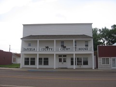 | Daniels County Courthouse | building | 1995 | 95000535 |
| Mansfield A. Daniels House | building | 1997 | 97000503 | |
| LaPierre Barn | building | 2005 | 05000279 |
Every wildfire the federal occurrence database records inside this county: 35 of them, burning about 6,025 acres. 4 started naturally and 1 was recorded as arson. Each settlement page carries the fires within five miles of it.
| Reported cause | Fires |
|---|---|
| Missing data/not specified/undetermined | 15 |
| Equipment and vehicle use | 13 |
| Natural | 4 |
| Smoking | 1 |
| Arson/incendiarism | 1 |
| Debris and open burning | 1 |
The five largest, by the area the report gives. None of them was recorded as arson.
| Date | Cause | Size | Reported by | Name on the report |
|---|---|---|---|---|
| 16 July 2017 | Equipment and vehicle use | 1,650 acres | Daniels County | FOUR BUTTES |
| 23 August 1994 | Missing data/not specified/undetermined | 900 acres | Northeastern Land Office | TOWER HILL |
| 5 September 2001 | Missing data/not specified/undetermined | 880 acres | Fort Peck Agency | NORTH STENTOFT |
| 15 July 2018 | Equipment and vehicle use | 615 acres | Northeastern Land Office | not named |
| 29 August 2020 | Equipment and vehicle use | 450 acres | Daniels County | FDH-MTLG37-292 |
| 2 June 2020 | Equipment and vehicle use | 437 acres | Daniels County | THE WINDY |
| 3 October 2003 | Missing data/not specified/undetermined | 376 acres | Fort Peck Agency | RESBNDRY |
| 7 August 2010 | Natural | 200 acres | Fort Peck Agency | HWY 13 MM39 |
Every settlement page carries the fires within five miles of it - see the settlement index below.
The NOAA Storm Events Database holds 278 reports for this county, causing no deaths, no injuries and about $358,500 in recorded property damage. Each settlement page carries the reports that name it.
| Kind of event | Reports |
|---|---|
| Hail | 161 |
| Thunderstorm Wind | 74 |
| Tornado | 10 |
| Heavy Rain | 10 |
| Flood | 9 |
| Flash Flood | 8 |
| Funnel Cloud | 4 |
| Lightning | 2 |
The most serious of them, by death, then injury, then recorded damage. The accounts are quoted exactly as the forecast office filed them.
| When | Event | Place named | Harm | What the report says |
|---|---|---|---|---|
| August 2000 | Hail | Peerless | $150,000 | no account filed |
| June 1994 | Thunderstorm Wind | near Flaxville | $50,000 | Some trees and powerlines were downed. |
| March 1999 | Flood | Countywide | $30,000 | no account filed |
| July 2005 | Thunderstorm Wind | Four Buttes | $29,000 | A 15,000 bushel steel grain bin at the Four Buttes Farmer's Elevator was completely destroyed. |
| August 1997 | Thunderstorm Wind | Scobey | $25,000 | Thunderrstorm winds nicking southeast Daniels County did damage to a farm, destorying a barn, two grain bins and a corral. |
| August 1997 | Thunderstorm Wind | Four Buttes | $20,000 | Thunderstorm winds destoryed a house trailer and flattened soon to be combined wheat. One field of corn was completely stripped of its leaves. |
| July 2015 | Thunderstorm Wind | Whitetail | $15,000 | Daniels County dispatch relayed a public report of 3 grain hopper bins blown over by thunderstorm wind gusts, along with significant crop loss in the area. |
| July 2015 | Thunderstorm Wind | Scobey | $10,000 | Daniels County dispatch relayed a public report of a roof blown off a new addition to a home from thunderstorm wind gusts. |
| July 2015 | Thunderstorm Wind | Scobey | $6,000 | Daniel County dispatch relayed a public report of 6 power poles blown down from thunderstorm wind gusts. |
| August 1998 | Thunderstorm Wind | Scobey | $6,000 | A severe thunderstorm moved into Scobey while a concert was going on at the fair grounds. Loud speakers and equipment were blown off of the stage. Power was knocked out in parts of Scobey and the local radio station was off of the air. |
| June 2023 | Lightning | Flaxville | $5,000 | A trained spotter reported a direct lightning strike on a new series model tractor. The lightning strike fried the electronics and smoke was seen rising from the tractor cab. |
| July 2003 | Lightning | Whitetail | $5,000 | no account filed |
| June 1972 | Tornado (F1) | not stated | $2,500 | no account filed |
| June 1959 | Tornado | not stated | $2,500 | no account filed |
| May 2006 | Hail | Four Buttes | $1,000 | The hail was jagged in shape and accompanied by 30 mph wind, and broke out the back window of a truck. |
| June 1999 | Thunderstorm Wind | Whitetail | $1,000 | no account filed |
| July 2015 | Thunderstorm Wind | Four Buttes | $500 | Daniels County dispatch relayed a public report of a large picture window blown out by 60 mph winds. |
| April 2026 | Thunderstorm Wind | Navajo | - | The Navajo MT-5 DOT site (MTRED) recorded a 60 mph wind gust. |
| April 2026 | Thunderstorm Wind | Four Buttes | - | The Scobey NW Montana Climate Office mesonet site (SCYM8) recorded a 58 mph wind gust. |
| March 2025 | Flood | Four Buttes | - | The USGS river gauge on the Poplar River at the International Border reported minor flooding. |
| June 2025 | Hail | Scobey | - | Ping pong ball size hail was reported with a photo via social media. |
| August 2024 | Hail | Peerless | - | Public reported hail up to the size of tennis balls. Car body and windshield damage was also reported. |
| August 2024 | Hail | Four Buttes | - | Public reported hail up to the size of quarters. |
| August 2024 | Hail | Scobey | - | A trained spotter reported hail up to the size of quarters. |
| August 2024 | Hail | Scobey | - | Public reported hail up to the size of ping pong balls. |
| August 2024 | Hail | Whitetail | - | A trained spotter reported hail up to the size of golf balls. |
| September 2024 | Hail | Flaxville | - | The public reported, via Facebook, hail up to the size of half dollars. |
| June 2023 | Tornado (EFU) | Richland | - | Law enforcement and the public reported a landspout tornado near 8 SW West Fork. The tornado lasted about 10 minutes, with no visible damage to properties or fields. With no|visible indicators, the length of path and path width were estimated. |
| June 2023 | Flash Flood | Four Buttes | - | A trained spotter reported 2.3 inches of rainfall in a short period of time. Numerous fields were reported as flooding. |
| June 2023 | Heavy Rain | Scobey | - | A trained spotter reported 2.85 inches of rain falling during a 2 hour period. |
| July 2023 | Thunderstorm Wind | Navajo | - | The public reported that their neighbors horse trailer had been blown over. |
| July 2023 | Hail | Four Buttes | - | The public reported hail up to the size of golf balls. |
| July 2023 | Hail | Scobey | - | The public reported hail up to the size of quarters. |
| July 2022 | Thunderstorm Wind | Navajo | - | The Navajo MT-5 DOT site (MTRED) measured a thunderstorm wind gust of 60 mph. |
| July 2022 | Hail | Whitetail | - | Public reported, via Facebook, hail up to the size of ping pong balls. |
| July 2022 | Thunderstorm Wind | Flaxville | - | A trained spotter reported at least 15 power line poles had snapped and fallen over. |
| July 2022 | Hail | Whitetail | - | A trained spotter reported hail up to the size of half dollars along with heavy rainfall. |
| July 2022 | Hail | Flaxville | - | Public reported, via Facebook, hail up to the size of quarters. |
| July 2022 | Thunderstorm Wind | Navajo | - | A trained spotter measured a thunderstorm wind gust of 60 mph. |
| July 2021 | Hail | Peerless | - | Public reported, via Facebook, ping-pong ball size hail. Time estimated from radar. |
| July 2021 | Hail | Peerless | - | Public reported, via Facebook, quarter size hail. |
| July 2021 | Heavy Rain | Peerless | - | Public reported, via Facebook, 2 inches of rain. |
| July 2021 | Thunderstorm Wind | Scobey | - | Public reported, via Facebook, 65mph winds. |
| June 2021 | Heavy Rain | Peerless | - | Public reported, via Facebook, a rainfall total of 2.18 inches near the town of Peerless. |
| June 2021 | Heavy Rain | Flaxville | - | Public reported, via Facebook, a rainfall total of 2 inches from overnight in the town of Flaxville. |
| June 2021 | Thunderstorm Wind | Flaxville | - | Public reported a grain bin destroyed south of Flaxville on the R-Y Road. Time estimated from radar. |
| July 2021 | Thunderstorm Wind | Navajo | - | Mesonet site MTRED located on Montana state highway 5 near Navajo reported a wind gust of 67mph. |
| May 2020 | Thunderstorm Wind | Flaxville | - | Public reported, via Facebook, a 3-sided farm shed destroyed. Wind speed estimated. Time estimated from radar. |
| July 2020 | Hail | Scobey | - | Public reported plentiful hail up to the size of ping pong balls, lasting for approximately 15 to 20 minutes. |
| October 2020 | Thunderstorm Wind | Navajo | - | At the Navajo MT-5 DOT site (MTRED), a 58 mph wind gust was recorded. |
| June 2019 | Thunderstorm Wind | Scobey | - | Trained spotter reported newly installed siding blown off of a house. |
| July 2019 | Hail | Richland | - | Public reported hail up to the size of golf balls. |
| July 2019 | Hail | Peerless | - | Public reported hail up to the size of hen eggs. |
| July 2019 | Hail | Four Buttes | - | Trained spotter reported hail up to the size of quarters. |
| June 2018 | Hail | Four Buttes | - | Multiple reports from the public, all confirming golf ball size hail. Time estimated by radar. |
| July 2018 | Hail | Peerless | - | Trained spotter reported hail up to the size of golf balls. Time estimated from radar. |
| July 2018 | Hail | Peerless | - | Public reported golf ball size hail. |
| July 2018 | Thunderstorm Wind | Scobey | - | Public reported 60 mph wind gusts. |
| July 2018 | Hail | Scobey | - | Public reported quarter size hail. |
| July 2018 | Hail | Flaxville | - | Public reported quarter size hail. |
The Survey's mineral resources record lists 15 workings inside this county. None of them still produces: all are closed or unrecorded. Each settlement page carries the workings within five miles of it.
| Commodity | Workings |
|---|---|
| Sand and Gravel, Construction | 14 |
| Clay | 1 |
The least common of them first, because a county's hundredth gravel pit says nothing its first ten did not.
| Where | Site | Commodity | Status | Recorded |
|---|---|---|---|---|
| Clay Occurrence | Clay | Occurrence | ||
| Four Buttes Pit | Sand and Gravel, Construction | Past Producer | ||
| Gravel Pit | Sand and Gravel, Construction | Past Producer | ||
| Gravel Pit | Sand and Gravel, Construction | Unknown | ||
| Gravel Pit | Sand and Gravel, Construction | Unknown | ||
| Gravel Pit | Sand and Gravel, Construction | Unknown | ||
| Gravel Pit | Sand and Gravel, Construction | Unknown | ||
| Gravel Pit | Sand and Gravel, Construction | Past Producer | ||
| Gravel Pit | Sand and Gravel, Construction | Unknown | ||
| Gravel Pit | Sand and Gravel, Construction | Past Producer | ||
| Gravel Pit | Sand and Gravel, Construction | Unknown | ||
| Gravel Pit | Sand and Gravel, Construction | Unknown | ||
| Gravel Pit | Sand and Gravel, Construction | Unknown | ||
| Gravel Pit | Sand and Gravel, Construction | Unknown | ||
| Leonard Bud Jensen | Sand and Gravel, Construction | Past Producer |
Named settlements recorded in the Geographic Names Information System, each with the topographic sheets covering it. Villages, hamlets and abandoned places alike. Each is shown with the nearest named watercourse or landform and the survey quadrangle it falls on.
Scobey census division · 59260 · Near Lewarton Coulee · Carbert quadrangle
5 sheets, 1954 to 1983
Scobey census division · 59263 · On Spring Creek · Four Buttes quadrangle
5 sheets, 1954 to 1983
Scobey census division · 59263 · Si Merrell Slough quadrangle
5 sheets, 1954 to 1983
No longer a settlement
Fort Peck Reservation census division · 59263 · Nielsen Coulee quadrangle
5 sheets, 1954 to 1983
No longer a settlement
Fort Peck Reservation census division · 59260 · Blink Springs quadrangle
7 sheets, 1954 to 1984
No longer a settlement
Fort Peck Reservation census division · 59222 · Pleasant Prairie quadrangle
5 sheets, 1954 to 1983
The vanished settlements of Daniels County: the places named above that are no longer on the map.