 Block
From the record
2 National Register listings published here.
Sources: the National Register database, National Park Service
28 topographic sheets cover 19 settlements here, and 2 properties are on the National Register of Historic Places.
2 National Register listings published here.
Sources: the National Register database, National Park Service
Every property in this county listed on the National Register of Historic Places, with the year it was listed and the federal nomination document.
| Photograph | Property | Type | Listed | Reference |
|---|---|---|---|---|
 | Roundup Central School | building | 2007 | 07001243 |
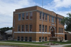 | St. Benedict's Catholic School | building | 1988 | 88001120 |
Every wildfire the federal occurrence database records inside this county: 137 of them, burning about 127,297 acres. 69 started naturally and none was recorded as arson. Each settlement page carries the fires within five miles of it.
| Reported cause | Fires |
|---|---|
| Natural | 69 |
| Missing data/not specified/undetermined | 56 |
| Equipment and vehicle use | 9 |
| Debris and open burning | 2 |
| Misuse of fire by a minor | 1 |
The five largest, by the area the report gives. None of them was recorded as arson.
| Date | Cause | Size | Reported by | Name on the report |
|---|---|---|---|---|
| 24 August 2012 | Natural | 40,085 acres | Billings Field Office | DELPHIA |
| 2 September 2020 | Missing data/not specified/undetermined | 30,030 acres | Musselshell County | BOBCAT |
| 26 June 2012 | Natural | 22,045 acres | Billings Field Office | DAHL |
| 8 September 1998 | Natural | 6,356 acres | Southern Land Office | BURNT SHED |
| 22 September 2012 | Missing data/not specified/undetermined | 4,100 acres | Southern Land Office | WILSON |
| 14 July 2017 | Natural | 3,800 acres | Billings Field Office | NORTH DELPHIA |
| 24 July 1999 | Natural | 3,500 acres | Miles City Field Office | HORSE THIE |
| 28 March 2015 | Missing data/not specified/undetermined | 1,700 acres | Musselshell County | SUNSET |
Every settlement page carries the fires within five miles of it - see the settlement index below.
The NOAA Storm Events Database holds 324 reports for this county, causing no deaths, no injuries and about $6,241,500 in recorded property damage. Each settlement page carries the reports that name it.
| Kind of event | Reports |
|---|---|
| Hail | 230 |
| Thunderstorm Wind | 45 |
| Flash Flood | 26 |
| Flood | 9 |
| Funnel Cloud | 6 |
| Tornado | 5 |
| Heavy Rain | 2 |
| Debris Flow | 1 |
The most serious of them, by death, then injury, then recorded damage. The accounts are quoted exactly as the forecast office filed them.
| When | Event | Place named | Harm | What the report says |
|---|---|---|---|---|
| May 2011 | Flood | Roundup Arpt | $6,000,000 | Persistent heavy rainfall combined with snowmelt in the mountains resulted in extensive and significant flooding along the Musselshell River and its tributaries, including the Roundup area where record flows were observed. The Musselshell River at the gauge at Roundup crested at a record of 14.78 feet on May 26th. As the water on the Musselshell rose quickly on the 26th, floodwaters quickly inundated the town of Roundup. Portions of Highways 12 and 87 were closed in and around Roundup with up to 8 feet of water covering the roads in spots. This completely cut off the town from surrounding areas for several days. Homes and businesses in Roundup were inundated by flood waters with water up to rooftop levels in some cases. 39 homes experienced major damage and were complete losses. Another 110 homes and businesses experienced at least minor flood damage. Four teenagers were rescued from the high waters after they disobeyed orders to stay out of the area and then became stranded. Further downstream on the Musselshell River, another 14 homes were damaged by the flood in the town of Musselshell. In all, hundreds of families were isolated due to the floodwaters and severely damaged roadways. Railroad tracks were reported as washed out in spots. Musselshell County was reported as one of the worst hit counties in the state of Montana. |
| July 1998 | Flash Flood | Roundup | $200,000 | A slow moving thunderstorm with heavy rain caused water to run over roads on the east end of Roundup. Over one inch of rain fell during a ten minute period. The Roundup Tribune reported that several basements were flooded. |
| May 1999 | Tornado (F0) | Roundup | $25,000 | Eyewitnesses reported seeing a funnel cloud pass over Roundup, and a tornado touchdown north of US12 1 mile east of Roundup. Several trees were downed, a chicken shed was demolished and several sections of wood fencing were destroyed. |
| August 1998 | Thunderstorm Wind | Roundup | $10,000 | A strong thunderstorm downed several trees and a few power lines in and around Roundup. |
| July 2000 | Thunderstorm Wind | Roundup | $3,000 | 2.00 inch hail reported along with broken windows. A hay bale was blown 50 yards. |
| May 1986 | Tornado (F2) | not stated | $2,500 | no account filed |
| August 1999 | Thunderstorm Wind | Roundup | $1,000 | Wind gusts to 60 mph damaged several large construction signs. |
| June 2025 | Hail | Roundup Arpt | - | One inch hail reported. |
| June 2025 | Funnel Cloud | Roundup Arpt | - | Corrects previous tornado report. Funnel cloud reported but no evidence of a confirmed touchdown. |
| July 2025 | Flood | Roundup | - | Spotter reported flooding of drainage ditches and streets. Water flowing up over lawn at hospital in Roundup. |
| July 2025 | Hail | Roundup | - | Quarter size hail reported. |
| July 2025 | Hail | Roundup Arpt | - | Spotter reported trees stripped badly. |
| July 2025 | Hail | Roundup Arpt | - | Observer reported hail went through patio roof. Drifts of hail. Flooding into basement. |
| July 2025 | Heavy Rain | Roundup | - | Got 1.27 ins in 30 minutes. Flooding on property. |
| June 2023 | Flash Flood | Klein | - | Some road damage was reported. |
| June 2023 | Flash Flood | Klein | - | East Parrot Creek road was underwater. West Parrot Creek Road and other rural/private roads in the vicinity that contained culverts were nearly washed out. |
| July 2022 | Flash Flood | Roundup Arpt | - | Numerous roads around US-87 were closed due to water over the roadway. |
| July 2022 | Hail | Roundup Arpt | - | Some windows were broken. |
| July 2020 | Hail | Elso | - | Golf ball size hail fell from 410-420pm. |
| July 2020 | Hail | Klein | - | The average hail size was 0.5 inches and covered the ground. |
| July 2020 | Hail | Musselshell | - | A window was broken. |
| May 2019 | Hail | Roundup Arpt | - | Roofs and siding were damaged along with at least 6 solarium windows. |
| June 2019 | Hail | Roundup | - | Quarter size hail was reported 5 miles west of Roundup. |
| June 2019 | Hail | Klein | - | Quarter size hail was reported in Klein. |
| May 2018 | Hail | Roundup | - | Seven windows were broken in a home. |
| May 2018 | Hail | Roundup | - | Some broken windows were reported. |
| May 2018 | Hail | Roundup | - | There was widespread golf ball to tennis ball size hail in Roundup. Please see Episode Narrative for this event. |
| May 2018 | Hail | Roundup | - | There was widespread golf ball to tennis ball size hail in Roundup. Please see Episode Narrative for this event. |
| May 2018 | Flash Flood | Roundup | - | Please see Episode Write-up. |
| May 2018 | Hail | Elso | - | The hail was 2 inches deep on a deck. |
| May 2018 | Hail | Elso | - | The hail was 2 inches deep on a deck. |
| June 2018 | Flash Flood | Musselshell | - | The peak river stage of the Musselshell River at Roundup was 11.5 feet, a foot and a half above flood stage and the sixth highest crest on record. These high water levels moved downstream toward the town of Melstone where flooding was reported along Highway 12 between Roundup and Melstone. Bender Road was washed out between Log Cabin Road and County Road #4. In addition, Ragged Point Road was washed out approximately 9 miles up near the CRP Fields. |
| March 2014 | Flood | Roundup Arpt | - | County officials reported low land and small stream flooding impacting portions of Musselshell County...mainly small creeks emerging from the Snowy and Bull Mountains. |
| March 2014 | Flood | Elso | - | County officials and the Montana Department of Transportation reported significant flooding of streams and low lying areas across the area. The combination of rapid snow melt and ice resulted in high water levels along the Musselshell River from Harlowton to Shawmut...Ryegate and Lavina. In addition, some county roads were reported to be impassable. |
| May 2013 | Debris Flow | Klein | - | Flash flooding occurred in the Dahl Fire burn scar area, especially along the drainages on the western side of the burn area. Water flowed across Buckskin Road and flooding was also significant in the Harper Coulee. |
| June 2013 | Thunderstorm Wind | Klein | - | Large tree branches were broken. |
| June 2013 | Hail | Roundup | - | Pea to quarter size hail with winds estimated at 50 mph were reported. |
| June 2013 | Hail | Roundup | - | Pea to quarter size hail was reported. |
| June 2013 | Flash Flood | Delphia | - | The County Emergency Manager reported flash flooding over the Dahl, Wilson, and Delphia Burn Scar areas. Water was running over private roads in the burn scar areas. |
| June 2013 | Hail | Roundup | - | Hail was quarter to half dollar size and was accompanied by 50 mph winds. |
| June 2013 | Hail | Roundup | - | Hail was nickel to quarter size and was accompanied by winds estimated at 70 to 80 mph. |
| June 2013 | Funnel Cloud | Klein | - | There were multiple funnel cloud reports. |
| June 2013 | Thunderstorm Wind | Musselshell | - | Numerous power poles were snapped. |
| July 2013 | Thunderstorm Wind | Roundup | - | Thunderstorm wind gusts brought down large tree branches. |
| July 2013 | Hail | Roundup Arpt | - | There was significant crop damage due to the hail and strong winds. The largest hailstones were estimated to be 3 inches in diameter, which is slightly larger than baseball size. Hail drifts were still 4 inches deep at 6 pm. Power outages also occurred in the area. |
| May 2013 | Flash Flood | Elso | - | There were numerous reports of flash flooding affecting all of the drainage's within the Dahl Fire burn scar area. Most of the private roads in the burn scar were reported as rivers and had severe erosion as most were over-topped. |
| May 2013 | Flash Flood | Delphia | - | There were several reports of flash flooding within the Delphia Burn Scar area. Some area roads were affected by washouts. |
| July 2013 | Flash Flood | Klein | - | Flash flooding again occurred across portions of the Dahl and Wilson Burn Scar areas with water running across many county roads. |
| June 2013 | Flash Flood | Elso | - | Flash flooding occurred along Buckskin Road near Harper Coulee in the Dahl Fire burn scar area. |
| June 2013 | Flash Flood | Klein | - | There were numerous spotter reports and DES (Department of Emergency Services) reports of flash flooding along Halfbreed Creek south of Roundup near the Wilson Burn area. The DES also reported high water and debris over numerous roads in the Dahl and Wilson Burn areas. |
| June 2013 | Flash Flood | Elso | - | Significant flooding occurred on Dean Creek along the Golden Valley/Musselshell County line. Driveways and fences were destroyed. |
| June 2013 | Flood | Elso | - | Emergency Managers and trained spotters reported flooding and significant debris flows over and near the Dahl, Delphia and Wilson Burn Scar areas. The city of Roundup experienced street flooding. Many secondary roads in the area were washed out. Flooding also occurred on Dean Creek just southwest of Roundup resulting in damage to driveways and fences. |
| June 2013 | Flash Flood | Klein | - | Several roads in the Dahl and Wilson Burn Scar areas were impacted by flash flooding, including Harper Coulee, Buckskin, Shortcut, Hampton, McCord and Aspen. Many private roads experienced significant erosion due to very heavy rainfall. Radar estimated 1 to 2 inches in an hour. |
| June 2013 | Flash Flood | Klein | - | Flash flooding occurred across portions of the Wilson and Dahl Fire burn scar areas. Radar estimated between 1 and 2 inches of rain fell in an hour. |
| June 2013 | Flash Flood | Delphia | - | Fast moving water, approximately 1 foot deep, flooded private roadways. |
| September 2013 | Flash Flood | Elso | - | Flash flooding was reported on the Dahl Burn Scar area with water running across numerous roads. |
| September 2013 | Flash Flood | Delphia | - | Flash flooding was reported on the Delphia Fire Burn Scar area with water running across numerous roads. |
| September 2013 | Flash Flood | Elso | - | Water was reported running across county and private roads within the Dahl, Delphia, and Wilson Burn Scar areas. |
| July 2013 | Thunderstorm Wind | Roundup Arpt | - | A wind gust was estimated at 60 mph southwest of Flatwillow. |
| July 2013 | Thunderstorm Wind | Elso | - | A wind gust of 60 mph was estimated southeast of Lavina. |
Named settlements recorded in the Geographic Names Information System, each with the topographic sheets covering it. Villages, hamlets and abandoned places alike. Each is shown with the nearest named watercourse or landform and the survey quadrangle it falls on.
Melstone census division · 59054 · On Carpenter Creek · Queens Point quadrangle
9 sheets, 1954 to 1983
No longer a settlement
Roundup census division · 59072 · On Halfbreed Creek · Roundup quadrangle
6 sheets, 1954 to 1979
Klein census division · 59072 · Near Deadman Coulee · Roundup quadrangle
6 sheets, 1954 to 1979
Klein census division · 59072 · Dunn Mountain North quadrangle
6 sheets, 1954 to 1980
No longer a settlement
Klein census division · 59072 · Near Fletchers Coulee · Roundup quadrangle
6 sheets, 1954 to 1979
Roundup census division · 59072 · Big Wall East quadrangle
6 sheets, 1954 to 1993
Klein census division · 59072 · Near Deadman Coulee · Roundup quadrangle
6 sheets, 1954 to 1979
Melstone census division · 59054 · On Lost Horse Creek · Melstone quadrangle
9 sheets, 1954 to 1983
Melstone census division · 59059 · On Fourmile Creek · Musselshell quadrangle
7 sheets, 1954 to 1993
Melstone census division · 59054 · On Carpenter Creek · Queens Point quadrangle
9 sheets, 1954 to 1983
Klein census division · 59072 · Near Deadman Coulee · Roundup quadrangle
6 sheets, 1954 to 1979
No longer a settlement
Roundup census division · 59072 · On Halfbreed Creek · Roundup quadrangle
6 sheets, 1954 to 1979
Roundup census division · 59072 · Timber Buttes North quadrangle
6 sheets, 1954 to 1993
No longer a settlement
The vanished settlements of Musselshell County: the places named above that are no longer on the map.