 Block
From the record
5 National Register listings published here.
Sources: the National Register database, National Park Service
42 topographic sheets cover 14 settlements here, and 5 properties are on the National Register of Historic Places.
5 National Register listings published here.
Sources: the National Register database, National Park Service
Every property in this county listed on the National Register of Historic Places, with the year it was listed and the federal nomination document.
| Photograph | Property | Type | Listed | Reference |
|---|---|---|---|---|
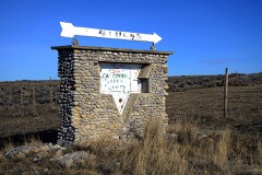 | Cat Creek Oil Field Sign | object | 2015 | 14001127 |
| Howard Lepper Memorial Hall | building | 2020 | 100005396 | |
| Lewistown Satellite Airfield Historic District (Boundary Increase III) | district | 2010 | 10000066 | |
 | Winnett Block | building | 2009 | 09000815 |
| Winnett School | building | 1995 | 95000383 |
Every wildfire the federal occurrence database records inside this county: 224 of them, burning about 136,408 acres. 188 started naturally and none was recorded as arson. Each settlement page carries the fires within five miles of it.
| Reported cause | Fires |
|---|---|
| Natural | 188 |
| Missing data/not specified/undetermined | 19 |
| Equipment and vehicle use | 9 |
| Debris and open burning | 3 |
| Recreation and ceremony | 3 |
| Power generation/transmission/distribution | 2 |
The five largest, by the area the report gives. None of them was recorded as arson.
| Date | Cause | Size | Reported by | Name on the report |
|---|---|---|---|---|
| 21 August 2010 | Natural | 27,898 acres | Charles M. Russell National Wildlife Refuge | RAT PATCH |
| 16 July 2006 | Natural | 23,000 acres | North Central Montana District | SODA CREEK FIRE |
| 24 July 2012 | Natural | 12,160 acres | North Central Montana District | WOLF CREEK |
| 1 August 2019 | Natural | 11,128 acres | North Central Montana District | RIDGETOP |
| 11 September 1996 | Missing data/not specified/undetermined | 10,031 acres | Charles M. Russell National Wildlife Refuge | ALKALIE |
| 19 July 2017 | Natural | 7,808 acres | Charles M. Russell National Wildlife Refuge | CRYING |
| 2 July 2015 | Natural | 5,762 acres | North Central Montana District | ALEX CAMP ROAD |
| 10 August 2006 | Natural | 4,524 acres | North Central Montana District | DOVETAIL |
Every settlement page carries the fires within five miles of it - see the settlement index below.
The NOAA Storm Events Database holds 225 reports for this county, causing 1 death, 1 injury and about $1,037,700 in recorded property damage. Each settlement page carries the reports that name it.
| Kind of event | Reports |
|---|---|
| Hail | 115 |
| Thunderstorm Wind | 72 |
| Flood | 17 |
| Tornado | 8 |
| Flash Flood | 7 |
| Wildfire | 2 |
| Heavy Rain | 2 |
| Lightning | 1 |
| Funnel Cloud | 1 |
The most serious of them, by death, then injury, then recorded damage. The accounts are quoted exactly as the forecast office filed them.
| When | Event | Place named | Harm | What the report says |
|---|---|---|---|---|
| September 1998 | Lightning | Winnett | 1 killed, 1 hurt | One man died after lightning struck him and a friend while the two were bow hunting. The two were hunting between Crooked Creek and Barrel Springs when a thunderstorm moved overhead. The two took cover under a tree. Lightning struck the pair knocking both unconscious. When the one man awoke he tried to revive his friend and then went for help. Help arrived in the remote area about two hours after the strike. The second man was pronounced dead at 9:50 p.m. |
| August 2014 | Flood | Winnett | $515,000 | Over 5 to 10 inches of rainfall fell in a four day period. This caused massive flooding in area creeks and streams. The most significant damage was from Flatwillow Creek into the Musselshell River. Cooperative weather observers noted it was the highest they had ever seen the water on Flatwillow Creek, including the 2011 flood season. It was high enough that the USGS gage on Flatwillow Creek was washed out and is gone, and the Flatwillow Road bridge was also washed out. The County DES coordinator reported over 30 locations with damages to culverts, roads and bridges with damages of at least $515,000. |
| June 2016 | Hail | Winnett | $500,000 | Petroleum County Emergency Manager reported hen egg sized hail, wind gusts to 50 mph, trees downed, roofs and siding damaged, and power outages. Event also resulted in 1 injury: A man was blown off his horse and later transported with injuries to Billings, MT. |
| July 1999 | Thunderstorm Wind | Winnett | $20,000 | no account filed |
| August 1962 | Tornado (F2) | not stated | $2,500 | no account filed |
| July 2008 | Thunderstorm Wind | Winnett | $200 | Eight inch diameter tree limbs were found snapped off and scattered on a nearby road. |
| April 2026 | Thunderstorm Wind | Winnett | - | The Winnett MT-200 DOT site (MTWIN) measured a 64 mph wind gust. |
| May 2025 | Thunderstorm Wind | Winnett | - | Occurred at the Mosby NW site. |
| June 2025 | Thunderstorm Wind | Teigen | - | The War Horse NW site (Montana Climate Office) recorded a wind gust of 62 mph. |
| June 2025 | Thunderstorm Wind | Teigen | - | The wind gust occurred at the Winnett Southwest MCO mesonet. |
| June 2025 | Hail | Winnett | - | Quarter-sized hail, heavy rain and 70 mph wind gusts caused considerable tree damage in Winnett. |
| June 2025 | Thunderstorm Wind | Winnett | - | Quarter-sized hail, heavy rain and 70 mph wind gusts caused considerable tree damage in Winnett. |
| June 2025 | Hail | Winnett | - | Hail up to the size of golf balls fell with winds of 30-40 mph. |
| June 2025 | Hail | Winnett | - | Golfball size hail was reported by Public. |
| June 2025 | Hail | Winnett | - | Large hail about 3.5 inches in diameter, lasted for about 15 mins. |
| June 2025 | Hail | Winnett | - | Ping pong ball size hail broke windows and damaged vehicles. |
| June 2025 | Hail | Winnett | - | A storm chaser measured multiple hailstones of 2.5 inches in diameter (tennis ball size) with a ruler. Report relayed through social media. |
| July 2025 | Hail | Flatwillow | - | Public reported hen egg size hail. |
| July 2025 | Thunderstorm Wind | Winnett | - | Trained spotter measured a 60 mph wind gust. |
| July 2025 | Thunderstorm Wind | Winnett | - | A wind gust of 63 mph was measured by the Winnett MT-200 DOT site. |
| July 2025 | Hail | Winnett | - | Trained spotter reported golf ball size hail. |
| July 2025 | Thunderstorm Wind | Winnett | - | Trained spotter reported a 60 mph wind gust. |
| July 2025 | Thunderstorm Wind | Flatwillow | - | A wind gust of 66 mph was measured at the Mosby South HydroMet site (Montana Climate Office network). |
| August 2025 | Thunderstorm Wind | Winnett | - | Trained spotter reported trees swaying significantly and estimated wind gusts of 50 to 60 mph along with pea sized hail. |
| August 2025 | Thunderstorm Wind | Teigen | - | The War Horse NW HydroMet site (WRHM8) from the Montana Climate Office Mesonet recorded a 59 mph wind gust. |
| August 2025 | Thunderstorm Wind | Teigen | - | The War Horse NW HydroMet site (WRHM8) from the Montana Climate Office Mesonet recorded a 61 mph wind gust. |
| August 2025 | Thunderstorm Wind | Winnett | - | The Winnett MT-200 DOT site (MTWIN) recorded a 59 mph wind gust. |
| August 2025 | Thunderstorm Wind | Winnett | - | The Mosby NW HydroMet site (MOBM8) from the Montana Climate Office Mesonet recorded a 60 mph wind gust. |
| August 2025 | Thunderstorm Wind | Dry Blood Creek Raws | - | The Dovetail / Valentine E HydroMet site (VLTM8) from the Montana Climate Office Mesonet recorded a 64 mph wind gust. |
| June 2024 | Thunderstorm Wind | Winnett | - | The Mosby NW mesonet site (MOBM8) measured a 58 mph thunderstorm wind gust. |
| June 2023 | Flash Flood | Flatwillow | - | Law enforcement reported water flowing over the roadway on U.S. Highway 87 at mile marker 22. |
| July 2023 | Hail | Winnett | - | The public reported hail up to the size of quarters. |
| June 2022 | Thunderstorm Wind | Winnett | - | Law enforcement reported trees up to 36 inches in diameter being blown down. |
| June 2022 | Thunderstorm Wind | Dry Blood Creek Raws | - | The Dry Blood Creek RAWS site (DBCM8) recorded a 71 mph thunderstorm wind gust. |
| July 2022 | Hail | Winnett | - | Public reported hail up to the size of quarters. |
| July 2022 | Flood | Winnett | - | Petroleum County Sheriff reported water covered roads and fields around and in the town of Winnett. |
| July 2022 | Thunderstorm Wind | Winnett | - | A trained spotter estimated a thunderstorm wind gust of 60 mph. Heavy rainfall and pea size hail covering the ground was also observed. |
| July 2022 | Hail | Winnett | - | Petroleum County Sheriff reported hail up to the size of quarters, blown into drifts. |
| June 2021 | Hail | Flatwillow | - | Public reported, via Facebook, quarter size hail located off of US Highway 87, five miles north of the Musselshell County line. Time estimated from radar. |
| August 2021 | Hail | Teigen | - | Public reported half dollar size hail. |
| August 2021 | Hail | Winnett | - | Public reported, via Facebook, quarter size hail. |
| August 2021 | Hail | Winnett | - | Law enforcement reported quarter size hail on Montana Highway 200, 2 miles east of Winnett. |
| August 2021 | Flood | Winnett | - | Petroleum County Dispatch reported some water coming out of a coulee 2 miles east of Winnett. |
| May 2020 | Hail | Winnett | - | The Petroleum County Emergency Manager reported hail stones up to the size of golf balls. |
| July 2020 | Hail | Winnett | - | Petroleum County Emergency Manager reported hail up to the size of half dollars. |
| July 2020 | Tornado (EF0) | Dry Blood Creek Raws | - | Petroleum County dispatch and Emergency Manager relayed a public report of a brief, rain-wrapped, weak tornado northwest of Winnett. No damage was found. |
| July 2020 | Tornado (EF0) | Winnett | - | Petroleum County dispatch relayed a public report of a brief, weak gustnado spun up out of severe thunderstorm outflow winds southwest of Winnett. Time estimated from radar. |
| July 2020 | Thunderstorm Wind | Chain Buttes Raws | - | At the Lewsotwn Port #1 RAWS site (TR464), a 62 mph wind gust was recorded. |
| August 2019 | Hail | Flatwillow | - | Public reported hail up to the size of golf balls. |
| August 2019 | Hail | Winnett | - | Trained spotter reported, via social media, tea cup size hail stones (3 inches in diameter). |
| August 2019 | Hail | Flatwillow | - | Trained spotter reported quarter size hail, along with heavy rain and trees bending in the wind. |
| July 2019 | Thunderstorm Wind | Winnett | - | Trained spotter reported wind damage in the town of Winnett, including power lines and trees blown down, and a roof ripped off a house. Time estimated by radar. |
| July 2019 | Thunderstorm Wind | Dry Blood Creek Raws | - | Trained spotter measured a 63 mph wind gust. |
| July 2019 | Thunderstorm Wind | Winnett | - | A 78 mph wind gust was measured at the Winnett Handar site (GGWWT). |
| June 2019 | Hail | Flatwillow | - | Public reported golf ball size hail. Time estimated from radar. |
| June 2019 | Hail | Flatwillow | - | Petroleum County DES Coordinator estimated hail up to the size of quarters still on the road, twenty minutes after the storm passed. |
| May 2019 | Flood | Winnett | - | In response to the heavy rain from the previous few days, Petroleum County DES Coordinator reported that many creeks and streams across most of southern Petroleum County were running out of their banks and crossing multiple county roads. Times are estimated. |
| March 2018 | Flood | Winnett | - | During the evening of March 12st, at the Mosby river forecast point (MSBM8) along the Musselshell River, an ice jam suddenly caused the river level to briefly rise above the flood stage of 10 feet at 5:24 PM MST. Even though the river fell back down below 10 feet just 9 minutes later, at 5:33 PM MST, it quickly rose above 10 feet again at 6:14 PM MST. The river crested at 11.53 feet at 6:59 PM MST. As the ice jam cleared, the river fell back down below flood stage at 7:20 PM MST. |
| June 2018 | Flood | Winnett | - | The Musselshell River at Mosby (MSBM8) rose above the flood stage of 10 feet at 12:05 pm MST on June 1st, crested at 11.1 feet at 3:55 pm MST that same day, then fell back down below 10 feet at 7:07 am MST on June 2nd. |
| June 2018 | Hail | Dry Blood Creek Raws | - | Trained spotter reported quarter size hail. |
Named settlements recorded in the Geographic Names Information System, each with the topographic sheets covering it. Villages, hamlets and abandoned places alike. Each is shown with the nearest named watercourse or landform and the survey quadrangle it falls on.
Winnett North census division · 59032 · Teigen NW quadrangle
8 sheets, 1954 to 1986
No longer a settlement
Winnett North census division · 59087 · Near Lane Coulee · Davis Spring quadrangle
8 sheets, 1954 to 1986
No longer a settlement
Winnett South census division · 59087 · On Pike Creek · Flatwillow quadrangle
6 sheets, 1954 to 1993
Winnett South census division · 59087 · Near Bull Springs Coulee · Ingals Dam quadrangle
8 sheets, 1954 to 1986
No longer a settlement
Winnett North census division · 59087 · Cat Creek quadrangle
9 sheets, 1954 to 1986
No longer a settlement
Winnett North census division · 59087 · Germaine Coulee West quadrangle
9 sheets, 1954 to 1993
No longer a settlement
Winnett North census division · 59087 · Ingals Dam quadrangle
8 sheets, 1954 to 1986
No longer a settlement
Winnett South census division · 59072 · Flatwillow quadrangle
6 sheets, 1954 to 1993
No longer a settlement
Winnett South census division · 59058 · On Flatwillow Creek · Mosby quadrangle
9 sheets, 1954 to 1983
No longer a settlement
The vanished settlements of Petroleum County: the places named above that are no longer on the map.