 Block
From the record
One of 90 National Register listings published here for Missoula County · listed in 2018 · category: Building · built in 1957.
Sources: the National Register database, National Park Service
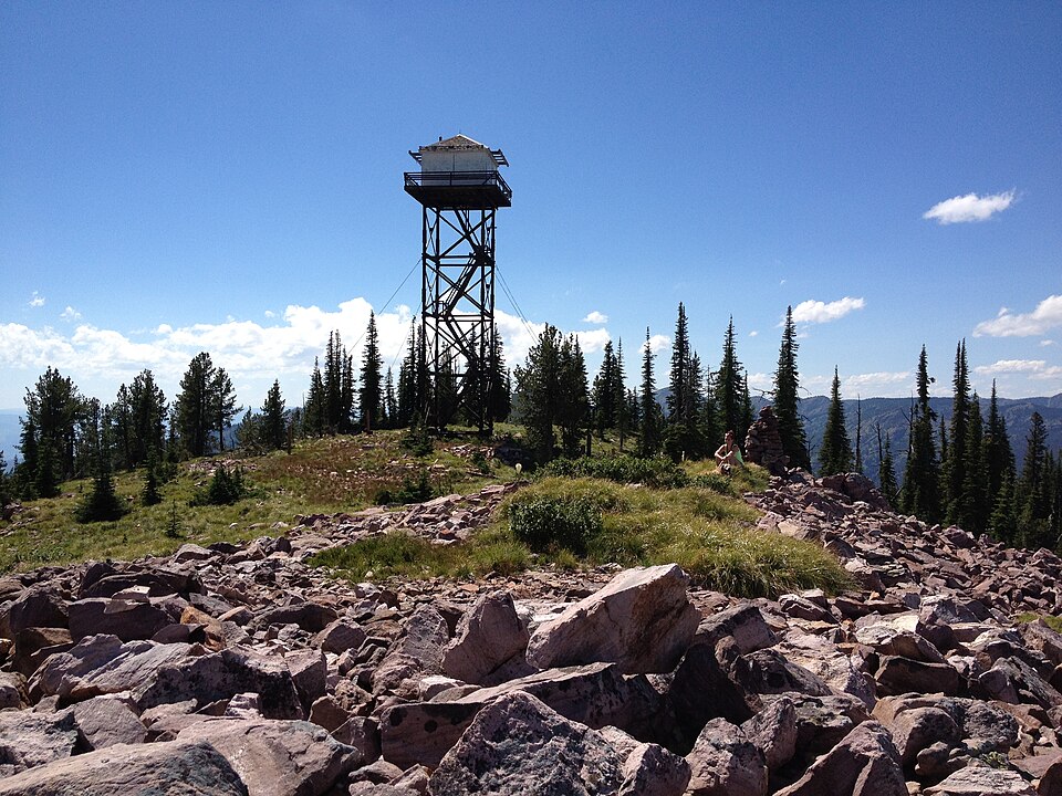
Built in 1957. Listed on the National Register of Historic Places in 2018.
One of 90 National Register listings published here for Missoula County · listed in 2018 · category: Building · built in 1957.
Sources: the National Register database, National Park Service
Regional context, not property-specific evidence. The federal wildfire occurrence database lists 77 fires within 5 miles of Mineral Peak Lookout between 1992 and 2019, burning about 25,935 acres in total. 40 started naturally. None was recorded as arson. Distance is straight-line from the map coordinates, so a fire counted here may appear on a neighbouring settlement's page as well.
| Reported cause | Fires |
|---|---|
| Natural | 40 |
| Missing data/not specified/undetermined | 27 |
| Recreation and ceremony | 9 |
| Equipment and vehicle use | 1 |
The most recent of them, most recent first, with the day each was reported and the service that recorded it.
| Date | Cause | Size | Reported by | Name on the report |
|---|---|---|---|---|
| 27 September 2002 | Recreation and ceremony | under an acre | Southwestern Land Office | not named |
| 2 September 2013 | Natural | under an acre | Lolo National Forest | CARTER LAKE |
| 2 September 1998 | Natural | 245 acres | Lolo National Forest | BOULDER LAKE |
| 17 September 2000 | Natural | under an acre | Lolo National Forest | MINERAL PEAK |
| 17 September 1993 | Recreation and ceremony | under an acre | Lolo National Forest | not named |
| 13 September 1996 | Natural | under an acre | Helena - Lewis and Clark National Forest | STONEWALL CREEK |
| 11 September 2016 | Missing data/not specified/undetermined | under an acre | Southwestern Land Office | not named |
| 10 September 1999 | Recreation and ceremony | under an acre | Lolo National Forest | FRANKLIN BRIDGE |
Regional context, not property-specific evidence. The federal mineral resources record lists 5 workings within 5 miles of Mineral Peak Lookout: 5 occurrences. None of them still produces. What was taken out: Barium-Barite, Limestone, General, Gold. Distance is straight-line from the map coordinates, so a quarry counted here may appear on a neighbouring settlement's page as well.
| Where | Site | Commodity | Status | Recorded |
|---|---|---|---|---|
| Mineral Peak Prospect | Gold | Occurrence | ||
| Lime Kiln Prospect | Limestone, General | Occurrence | ||
| Montana Power Co. Barite Prospect | Barium-Barite | Occurrence | ||
| Sheep Moutain Prospect | Barium-Barite | Occurrence | ||
| Unnamed Limestone Prospect | Limestone, General | Occurrence |
Regional context, not property-specific evidence. The National Weather Service names Missoula, the town this property stands in, in 58 storm reports between 1993 and 2025: 32 thunderstorm wind, 17 hail, 3 lightning, 2 dust devil. The reports record 2 deaths and 3 injuries. Each account below is quoted exactly as the forecast office filed it, from the NOAA Storm Events Database, and each date opens the federal record of that event.
| When | Event | Place named | Harm | What the report says |
|---|---|---|---|---|
| July 1998 | Lightning | Missoula | 1 killed, 1 hurt | no account filed |
| July 1998 | Thunderstorm Wind | Missoula | 1 killed, $260,000 | no account filed |
| July 2002 | Thunderstorm Wind | Missoula | 1 hurt | no account filed |
| July 2002 | Lightning | Missoula | 1 hurt | no account filed |
| August 2003 | Wildfire | Missoula | $250,000 | no account filed |
| August 1993 | Thunderstorm Wind | Missoula | $50,000 | Strong winds destroyed a tent at the Western Montana Fair and blewdown several trees. |
| August 1993 | Thunderstorm Wind | Missoula | $50,000 | Trees and powerlines were downed by thunderstorm winds. |
| July 2003 | Dust Devil | Missoula | $40,000 | no account filed |
| June 2003 | Thunderstorm Wind | Missoula | $30,000 | no account filed |
| August 2003 | Thunderstorm Wind | Missoula | $25,000 | no account filed |
| April 2012 | Thunderstorm Wind | Missoula | $18,000 | The broadcast media reported a tree limb fell and crushed an outbuilding in the Orchard homes development at 315pm. |
| August 2025 | Heavy Rain | Missoula | $5,000 | A public report described torrential rain of approximately 20 minutes in duration and roadway ponding near Bernices Bakery around 1600MST; additionally, the roof of new annex started leaking. |
| May 2018 | Thunderstorm Wind | Missoula | $5,000 | Several large trees were uprooted and fell onto two cars and a house. The Missoula International Airport ASOS reported a gust to 48 mph while a sensor on top of Mount Sentinel recorded a 68 mph wind gust. A local power company reported at least 2,000 customers were without power for at least three hours. |
| August 2016 | Thunderstorm Wind | Missoula | $5,000 | Two transmission poles located in the South Hills area of Missoula were knocked out by the wind which caused a power outage. Multiple trees were pushed over by the wind including a 50 foot Ponderosa Pine tree that fell onto a home. A NWS employee reported that a Maple tree was snapped in half at the corner of Mount and Brooks Street. |
| May 1993 | Thunderstorm Wind | Missoula | $5,000 | no account filed |
| August 2009 | Thunderstorm Wind | Missoula | $4,000 | Thunderstorms that moved from the Bitterroot Valley northward to the Missoula Valley, blew down two rotten cottonwood trees in Hamilton, and three trees in the city of Missoula. |
| June 2012 | Thunderstorm Wind | Missoula | $1,000 | Multiple trees were blown down on the south side of Missoula. One tree was 10-12 inches in diameter and was snapped off at the base. |
| July 2012 | Hail | Missoula | $500 | Hail of 1/4 to 1/2 inch diameter was reported, also 0.45 inch of rain fell in 10 minutes. |
| June 2022 | Hail | Missoula | - | Quarter size hail in the Rattlesnake area to the northeast of Missoula. |
| August 2016 | Hail | Missoula | - | A person from the public located in Missoula tweeted a photo of hail that appeared to be quarter size. There were multiple reports of nickel sized hail with some damage to gardens and vegetation. Intense rainfall was also produced by this storm, and the greater impact may have been street ponding. |
| August 2016 | Dust Devil | Missoula | - | A person from the public observed a prominent dust devil in northern Missoula. It formed ahead of showers that were tracking south to north in a very unstable environment. No damage was reported. |
| July 2013 | Hail | Missoula | - | A right-moving supercell moved across the Missoula International airport and brought penny sized hail. |
| April 2012 | Thunderstorm Wind | Missoula | - | Trained spotter reported a large spruce tree blown over 4 miles n of East Missoula. |
| August 2012 | Thunderstorm Wind | Missoula | - | A thunderstorm wind gust of 58 mph was recorded by the Point six RAWS, at an elevation of 7929 feet. |
| August 2012 | Thunderstorm Wind | Missoula | - | Trees were downed near the cross streets of Phillips and Cowper by a thunderstorm wind gust. |
| May 2007 | Hail | Missoula | - | One inch diameter hail was reported from the Grant Creek area. |
| June 2007 | Thunderstorm Wind | Missoula | - | A large tree was blown down onto a house on River Road. Another large tree was blown down on Bancroft Road. |
| May 1998 | Thunderstorm Wind | Missoula | - | Power lines reported down from thunderstorm winds. |
| June 1995 | Thunderstorm Wind | Missoula | - | Thunderstorms winds blew part of the roof off the grandstand at the city fairgrounds. Roof damage was also reported at the Fine Arts center on the campus of the University of Missoula. A gust of 68 mph was recorded at the National Weather Service office in Missoula. |
| April 2006 | Heavy Rain | Missoula | - | no account filed |
| June 2006 | Hail | Missoula | - | no account filed |
| June 2006 | Hail | Missoula | - | no account filed |
| August 2006 | Hail | Missoula | - | no account filed |
| August 2006 | Thunderstorm Wind | Missoula | - | no account filed |
| June 2004 | Hail | Missoula | - | no account filed |
| September 2004 | Thunderstorm Wind | Missoula | - | no account filed |
| August 2003 | Thunderstorm Wind | Missoula | - | no account filed |
| April 2003 | Funnel Cloud | Missoula | - | no account filed |
| May 2003 | Hail | Missoula | - | no account filed |
| May 2003 | Thunderstorm Wind | Missoula | - | no account filed |
| June 2003 | Lightning | Missoula | - | no account filed |
| June 2003 | Hail | Missoula | - | no account filed |
| June 2003 | Hail | Missoula | - | no account filed |
| June 2002 | Thunderstorm Wind | Missoula | - | no account filed |
| August 2002 | Hail | Missoula | - | no account filed |
| August 2002 | Hail | Missoula | - | no account filed |
| August 2002 | Thunderstorm Wind | Missoula | - | no account filed |
| June 2001 | Hail | Missoula | - | no account filed |
| June 2001 | Thunderstorm Wind | Missoula | - | no account filed |
| July 2001 | Thunderstorm Wind | Missoula | - | no account filed |
| June 1999 | Thunderstorm Wind | Missoula | - | no account filed |
| July 1998 | Hail | Missoula | - | no account filed |
| September 1997 | Thunderstorm Wind | Missoula | - | no account filed |
| June 1996 | Thunderstorm Wind | Missoula | - | no account filed |
| June 1996 | Thunderstorm Wind | Missoula | - | no account filed |
| August 1996 | Hail | Missoula | - | no account filed |
| September 1996 | Thunderstorm Wind | Missoula | - | no account filed |
| August 1995 | Thunderstorm Wind | Missoula | - | no account filed |
No historic map-sheet match is published for this property yet. That does not mean no map exists. This record needs a coordinate-quality review before it can be joined to a sheet boundary. Browse the county's mapped places while that work is pending.
| National Archives record | The nomination case file for reference 100002042 in Record Group 79. |
| Missoula County | All 90 listed properties in this county. |