 Block
From the record
One of 48 National Register listings published here for Fergus County · listed in 1993 · category: Building.
Sources: the case file at the National Archives · the National Register database, National Park Service
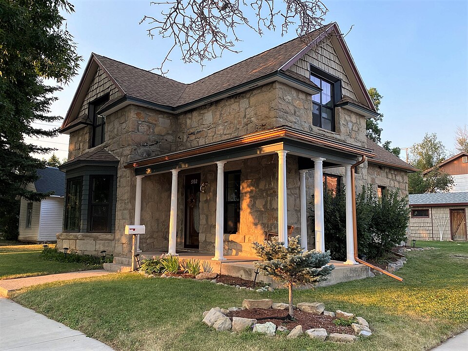
Listed on the National Register of Historic Places in 1993.
One of 48 National Register listings published here for Fergus County · listed in 1993 · category: Building.
Sources: the case file at the National Archives · the National Register database, National Park Service
Regional context, not property-specific evidence. The federal wildfire occurrence database lists 4 fires within 5 miles of Schroeder Hospital between 2017 and 2019, burning about 2 acres in total. None started naturally. None was recorded as arson. Distance is straight-line from the map coordinates, so a fire counted here may appear on a neighbouring settlement's page as well.
| Reported cause | Fires |
|---|---|
| Missing data/not specified/undetermined | 3 |
| Debris and open burning | 1 |
The most recent of them, most recent first, with the day each was reported and the service that recorded it.
| Date | Cause | Size | Reported by | Name on the report |
|---|---|---|---|---|
| 4 August 2019 | Missing data/not specified/undetermined | under an acre | Fergus County | FDH-MTLG08-116 |
| 30 July 2017 | Missing data/not specified/undetermined | 1.0 acres | Northeastern Land Office | not named |
| 10 July 2017 | Missing data/not specified/undetermined | under an acre | Northeastern Land Office | not named |
| 5 May 2018 | Debris and open burning | 1.0 acres | Northeastern Land Office | not named |
Regional context, not property-specific evidence. The federal mineral resources record lists 8 workings within 5 miles of Schroeder Hospital: 4 producers, 3 occurrences, 1 past producer. 4 still produce. What was taken out: Sand and Gravel, Construction, Clay, Limestone, Dimension. Distance is straight-line from the map coordinates, so a quarry counted here may appear on a neighbouring settlement's page as well.
| Where | Site | Commodity | Status | Recorded |
|---|---|---|---|---|
| Castle Butte | Limestone, Dimension | Occurrence | ||
| Lewiston Pit | Clay | Producer | ||
| Unnamed Location | Clay | Occurrence | ||
| Unnamed Location | Clay | Occurrence | ||
| Casino Creek Concrete | Sand and Gravel, Construction | Producer | ||
| Konitz #1 | Sand and Gravel, Construction | Producer | ||
| Mcdonald Sand and Gravel Pit | Sand and Gravel, Construction | Past Producer | ||
| Welkers Sand & Gravel | Sand and Gravel, Construction | Producer |
Regional context, not property-specific evidence. The National Weather Service names Lewistown, the town this property stands in, in 73 storm reports between 1994 and 2025: 36 hail, 27 thunderstorm wind, 6 tornado, 1 funnel cloud. The reports record 3 injuries. Each account below is quoted exactly as the forecast office filed it, from the NOAA Storm Events Database, and each date opens the federal record of that event.
| When | Event | Place named | Harm | What the report says |
|---|---|---|---|---|
| August 1999 | Tornado (F2) | Lewistown | 3 hurt, $4,000,000 | NUMEROUS HAIL REPORTS 1 TO 2 INCHES...ONE WIND ESTIMATE AHEAD OF TORNADO 87KT |
| June 2023 | Flood | Lewistown | $10,000 | Big Spring Creek south of Lewistown came out of its banks in several areas, resulting in flooding. Several small parks and boat entrances were closed and underwater as a result. Nearby and surrounding tributaries also flooded. |
| July 1994 | Thunderstorm Wind | Lewistown | $5,000 | Several trees were blown down. |
| May 1994 | Hail | Lewistown | $5,000 | no account filed |
| July 2025 | Thunderstorm Wind | Lewistown | $3,000 | Trees down along the Lewistown Trail System blocking the trail. Time estimated based on radar. |
| June 1999 | Tornado (F0) | Lewistown | $3,000 | no account filed |
| July 2000 | Thunderstorm Wind | Lewistown | $1,000 | 0.75 inch hail and 52kt wind gust...funnel cloud...windows broke out of house. |
| July 2025 | Thunderstorm Wind | Lewistown | $500 | Corrects previous thunderstorm wind dmg report from 1 NW Lewistown. Public reported on social media that an abandoned lumber shop collapsed due to the thunderstorms with photos of debris across the property. Time estimated based on radar. |
| August 2024 | Thunderstorm Wind | Lewistown | - | A trained spotter in Lewistown reported a severe caliber gust. |
| June 2023 | Hail | Lewistown | - | Spotter reported hail fell for roughly 15 minutes and was of various sizes. Largest was ping pong size. Impacts from the hail to hay crops were reported. |
| June 2023 | Hail | Lewistown | - | Spotter reported quarter size hail. |
| June 2023 | Hail | Lewistown | - | Public submitted photos of hail near Lewistown Pool being compared to a quarter. |
| July 2023 | Hail | Lewistown | - | Pictures submitted of hail in Lewistown slightly larger than one inch. |
| July 2021 | Thunderstorm Wind | Lewistown | - | Spotter reported winds snapping off large tree branches, also had pea-size hail. |
| July 2021 | Hail | Lewistown | - | Trained spotter reported quarter sized hail. |
| July 2021 | Thunderstorm Wind | Lewistown | - | A survey conducted by an NWS employee found damage consistent with straight line winds of 70 kts (80 mph). There was a downed power pole and a 12 foot section of roof damage on a building. |
| May 2020 | Hail | Lewistown | - | Trained spotter reports hail up to 1.25 inches in diameter covering the ground a few inches deep in areas. |
| July 2019 | Thunderstorm Wind | Lewistown | - | Trained spotter estimates 70 mph wind gust. Heavy rain and hail were falling at the time of observation. |
| July 2019 | Hail | Lewistown | - | One inch sized hail reported near Lewistown. |
| July 2019 | Heavy Rain | Lewistown | - | Brief heavy rainfall of .43 inches in 13 minutes, with pea sized hail. Some tree branches were knocked down during the storm. |
| June 2018 | Flash Flood | Lewistown | - | Lewistown News-Argus reported flash flooding in downtown Lewistown. The newspaper's building had basement flooding. Exact extent of flooding in Lewistown was unknown. |
| June 2018 | Hail | Lewistown | - | Spotter reported quarter-size hail and wind gusts up to 50 mph from thunderstorm 6-miles ESE of Lewistown. |
| July 2014 | Hail | Lewistown | - | Hail, measuring .75 inches (penny sized), with wind gusts to 40-50 MPH, were reported. |
| July 2011 | Hail | Lewistown | - | A thunderstorm dropped 1.75 inch diameter hail at Lewistown 4W. |
| June 2010 | Thunderstorm Wind | Lewistown | - | A thunderstorm produced a wind gust to 60 mph at Lewistown 2SW (the Lewistown ASOS site). |
| June 2010 | Thunderstorm Wind | Lewistown | - | A thunderstorm produced a wind gust to 70 mph at Lewistown 3E. |
| June 2010 | Hail | Lewistown | - | A thunderstorm produced 1 inch diameter hail at Lewistown. The hail accumulated to a depth of two inches on the ground. Power outages were reported in parts of the city. |
| May 2009 | Hail | Lewistown | - | Penny sized hail covered the ground. Wind gusts were estimated at 60 mph. |
| May 2009 | Hail | Lewistown | - | Three-quarter inch hail reported in Lewistown. |
| May 2009 | Thunderstorm Wind | Lewistown | - | Wind gust of 63 mph measured at the Lewistown Airport. |
| August 2009 | Thunderstorm Wind | Lewistown | - | A thunderstorm produced a wind gust to 60 mph at Lewistown 12NW. |
| August 2009 | Thunderstorm Wind | Lewistown | - | A thunderstorm produced a wind gust to 60 mph at Lewistown 12NNW. |
| July 2009 | Thunderstorm Wind | Lewistown | - | A thunderstorm produced a wind gust to 62 mph at Lewistown 2SW (the Lewistown ASOS site). |
| August 2009 | Hail | Lewistown | - | A severe thunderstorm dropped 1.75 inch diameter hail at Lewistown 17SE. |
| July 2008 | Thunderstorm Wind | Lewistown | - | A severe thunderstorm produced a wind gust to 60 mph at Lewistown 10SE. |
| June 2008 | Hail | Lewistown | - | A severe thunderstorm dropped 1.25 inch diameter hail at Lewistown 17SE. |
| July 2007 | Hail | Lewistown | - | A severe thunderstorm dropped .88 inch diameter hail at Lewistown. |
| July 2007 | Hail | Lewistown | - | A severe thunderstorm dropped .88 inch diameter hail at Lewistown. |
| July 2007 | Hail | Lewistown | - | A severe thunderstorm dropped .88 inch diameter hail at Lewistown 10E. |
| July 2007 | Hail | Lewistown | - | A severe thunderstorm dropped 1.75 inch diameter hail at Lewistown 20NNE. |
| July 2007 | Hail | Lewistown | - | A severe thunderstorm dropped 2.75 inch diameter hail at Lewistown 8E. |
| June 2005 | Tornado (F0) | Lewistown | - | A tornado was reported by the public at Lewistown 3E. The torndao was on the ground only briefly with no damage or injuries reported. |
| June 2004 | Tornado (F0) | Lewistown | - | Strong thunderstorms over southwest Fergus county spawned a second tornado during the evning hours of the 5th. This tornado also moved over rural areas of the county and caused little property damage. |
| July 2002 | Thunderstorm Wind | Lewistown | - | A dry microburst moved through the Lewistown area during the evening hours on the 14th. Wide spread tree damage occurred, causing power to be knocked out and damaging vehicles. |
| August 2002 | Hail | Lewistown | - | A severe thunderstorm produced 1.00 inch hail at Lewistown 15E. |
| July 2002 | Thunderstorm Wind | Lewistown | - | A severe thunderstorm produced 0.75 inch hail and wind gusts to 70 mph at Lewistown 10S. |
| July 2002 | Thunderstorm Wind | Lewistown | - | A severe thunderstorm produced a wind gust of 60 mph at Lewistown 8E. |
| July 2001 | Thunderstorm Wind | Lewistown | - | Microburst wind gust reported by general public in Lewistown...Branches ripped from trees and propelled into side of house...Shingles and six-foot wide sections of skirting ripped from mobile home...Tree uprooted and dropped on house and automobile...Large metal garbage container (dumpster) blown over...Boat moved by wind...Hot tub damaged...Monetary damage unknown. |
| July 2001 | Thunderstorm Wind | Lewistown | - | Actual spotter location Lewistown 10 S...Measured wind gust of 52 kt reported by ASOS at Lewistown Municipal Airport (occurring at same time). |
| July 2001 | Hail | Lewistown | - | Actual spotter location Lewistown 15 SE. |
| July 2001 | Hail | Lewistown | - | Actual spotter location Lewistown 10 E. |
| July 2001 | Hail | Lewistown | - | Actual spotter location Lewistown 7 E...Some crop damage reported...Monetary damage amounts unknown. |
| July 2001 | Hail | Lewistown | - | Actual event location Lewistown 15 SW. |
| July 2001 | Hail | Lewistown | - | Actual spotter location Lewistown 2 NW. |
| July 2000 | Thunderstorm Wind | Lewistown | - | 7/8 inch hail...wind gust estimated to 52kt. |
| June 1997 | Tornado (F0) | Lewistown | - | BRIEF TOUCHDOWN |
| July 2019 | Thunderstorm Wind | Lewistown | - | no account filed |
| May 2006 | Hail | Lewistown | - | no account filed |
| August 2006 | Hail | Lewistown | - | no account filed |
| June 2005 | Hail | Lewistown | - | no account filed |
No historic map-sheet match is published for this property yet. That does not mean no map exists. This record needs a coordinate-quality review before it can be joined to a sheet boundary. Browse the county's mapped places while that work is pending.
Other National Register properties close enough to walk or drive between, ordered by distance from this one. Both positions come from the same geocoding pass that matched these properties to their map sheets.
| Photograph | Property | Distance | Listed |
|---|---|---|---|
 | First Presbyterian Church | under 500 feet | 1986 |
 | House at 618 West Janeaux | under 500 feet | 1986 |
 | Clark-Cardwell House | under 500 feet | 1986 |
 | Fergus County High School | 0.2 miles | 1985 |
 | Masonic Temple | 0.2 miles | 1979 |
 | Culver Studio | 0.2 miles | 1980 |
| National Archives record | The nomination case file for reference 92001771 in Record Group 79. |
| Fergus County | All 48 listed properties in this county. |