 Block
From the record
One of 168 National Register listings published here for Flathead County · listed in 1994 · category: Structure.
Sources: the case file at the National Archives · the National Register database, National Park Service
Listed on the National Register of Historic Places in 1994.
One of 168 National Register listings published here for Flathead County · listed in 1994 · category: Structure.
Sources: the case file at the National Archives · the National Register database, National Park Service
Regional context, not property-specific evidence. The federal wildfire occurrence database lists 204 fires within 5 miles of Kearney Rapids Bridge between 1992 and 2020, burning about 136 acres in total. 16 started naturally. 4 were recorded as arson. Distance is straight-line from the map coordinates, so a fire counted here may appear on a neighbouring settlement's page as well.
| Reported cause | Fires |
|---|---|
| Missing data/not specified/undetermined | 86 |
| Debris and open burning | 53 |
| Recreation and ceremony | 18 |
| Natural | 16 |
| Power generation/transmission/distribution | 11 |
| Smoking | 5 |
| Equipment and vehicle use | 5 |
| Arson/incendiarism | 4 |
| Misuse of fire by a minor | 3 |
| Fireworks | 3 |
The most recent of them, most recent first, with the day each was reported and the service that recorded it.
| Date | Cause | Size | Reported by | Name on the report |
|---|---|---|---|---|
| 9 September 1997 | Missing data/not specified/undetermined | under an acre | Northwestern Land Office | SOUTH WHITETAIL |
| 8 September 2020 | Equipment and vehicle use | under an acre | Northwestern Land Office | BEAR CREEK |
| 7 September 2020 | Power generation/transmission/distribution | under an acre | Northwestern Land Office | SONGBIRD LANE |
| 7 September 2020 | Power generation/transmission/distribution | under an acre | Northwestern Land Office | RED OWL |
| 7 September 2020 | Missing data/not specified/undetermined | under an acre | Northwestern Land Office | RIPPLING WATERS ROAD |
| 4 September 2001 | Debris and open burning | under an acre | Northwestern Land Office | not named |
| 3 September 2009 | Power generation/transmission/distribution | under an acre | Northwestern Land Office | EAST ECHO LAKE |
| 24 September 1994 | Missing data/not specified/undetermined | under an acre | Northwestern Land Office | MILE MRK 29 HWY 35 |
Regional context, not property-specific evidence. The federal mineral resources record lists 1 working within 5 miles of Kearney Rapids Bridge: 1 unknown. None of them still produces. What was taken out: Sand and Gravel, Construction. Distance is straight-line from the map coordinates, so a quarry counted here may appear on a neighbouring settlement's page as well.
| Where | Site | Commodity | Status | Recorded |
|---|---|---|---|---|
| Gravel Pits | Sand and Gravel, Construction | Unknown |
Regional context, not property-specific evidence. The National Weather Service names Bigfork, the town this property stands in, in 18 storm reports between 1998 and 2020: 9 hail, 5 thunderstorm wind, 2 tornado, 1 flood. The reports record 1 death and 1 injury. Each account below is quoted exactly as the forecast office filed it, from the NOAA Storm Events Database, and each date opens the federal record of that event.
| When | Event | Place named | Harm | What the report says |
|---|---|---|---|---|
| July 2000 | Thunderstorm Wind | Bigfork | 1 killed, 1 hurt | no account filed |
| August 2019 | Thunderstorm Wind | Bigfork | $50,000 | Multiple thunderstorms collided together just south of Flathead Lake and produced a severe gust front that tracked north to the Flathead Valley. Multiple observers reported that the strong winds lasted for up to 15 minutes. Dozens of toppled trees, damaged power poles, transmission and distribution lines were reported from Bigfork up to Columbia Falls from strong winds. Power outages lasted for 24 hours. The golf course in Bigfork reported losing 59 trees, mostly spruce from 20 to 30 feet tall with diameters between 18 inches and 2.5 feet. The restaurant at the golf course lost all their food due to the power outage. |
| July 2007 | Tornado (EF0) | Bigfork | $8,000 | The public reported a waterspout on Flathead lake along the Flathead/Lake County line. A sailboat at this location was spun around at least once in a counterclockwise direction and then sank. |
| July 2011 | Hail | Bigfork | $1,000 | Trained spotter estimated nickel sized hail, with damage to apples and cherries in an orchard. A truck five miles north of Bigfork received some dents in it's hood. |
| November 2013 | Tornado (EF0) | Bigfork | - | A cold core upper level trough dropped out of British Columbia providing the necessary lift and instability to trigger showers across western Montana early on November 4th. The unstable atmosphere saw a 24 degree difference between Flathead Lake water temperatures(8.9 deg. C) and at 9,665 ft. MSL(700 millibars) -15 deg. C. A convergent boundary set up southwest of Wood's Bay with cool northerly winds coming out of the Flathead Valley and relatively mild southerly winds moving across the lake. This boundary provided the vertical lift to develop the band of graupel and snow showers. A waterspout was spotted by passers-by traveling on MT-83 near mile-marker 24. Viewing the photos and video that Mike and Dana Marchetti took, it appears that there could have been multiple vortices based on darkened shadows in the vicinity of the main vortex. The waterspout remained over Flathead Lake and no damage was reported. |
| October 2011 | Heavy Rain | Bigfork | - | Equipment at Noisy basin reported 0.70 inches of rainfall in 12 hours. |
| June 2007 | Thunderstorm Wind | Bigfork | - | The lodge owner in Wood's Bay reported an estimated wind gust to 60 mph about 1 mile east of town on the county line. |
| June 2020 | Hail | Bigfork | - | no account filed |
| July 2006 | Hail | Bigfork | - | no account filed |
| June 2006 | Hail | Bigfork | - | no account filed |
| June 2006 | Flood | Bigfork | - | no account filed |
| June 2006 | Hail | Bigfork | - | no account filed |
| June 2006 | Hail | Bigfork | - | no account filed |
| August 2006 | Hail | Bigfork | - | no account filed |
| August 2006 | Hail | Bigfork | - | no account filed |
| March 2003 | Thunderstorm Wind | Bigfork | - | no account filed |
| June 2002 | Hail | Bigfork | - | no account filed |
| May 1998 | Thunderstorm Wind | Bigfork | - | no account filed |
No historic map-sheet match is published for this property yet. That does not mean no map exists. This record needs a coordinate-quality review before it can be joined to a sheet boundary. Browse the county's mapped places while that work is pending.
Other National Register properties close enough to walk or drive between, ordered by distance from this one. Both positions come from the same geocoding pass that matched these properties to their map sheets.
| Photograph | Property | Distance | Listed |
|---|---|---|---|
| Swan River Bridge | 2.0 miles | 2015 | |
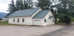 | Swan River Community Hall | 2.7 miles | 2002 |
| National Archives record | The nomination case file for reference 94000734 in Record Group 79. |
| Flathead County | All 168 listed properties in this county. |