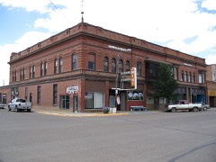
Also known as. Roadside Architecture Along US 2 in Montana MPS
Census division. Chinook
National Register reference number.94000862- the number the National Park Service assigned this property when it was listed, and the key its nomination file is catalogued under at the National Archives.
Fires near this property
5 since 2017
Regional context, not property-specific
evidence. The
federal wildfire occurrence database
lists 5 fires within 5 miles of Dave's Texaco
between 2017 and 2020, burning about 20 acres in total. 2 started naturally. None was recorded as arson.
Distance is straight-line from the map coordinates, so a fire counted
here may appear on a neighbouring settlement's page as well.
Reported cause
Fires
Natural
2
Equipment and vehicle use
2
Missing data/not specified/undetermined
1
The most recent of
them, most recent first, with the day each was reported and the service
that recorded it.
Regional context, not property-specific
evidence. The federal mineral resources record lists
2 workings within 5 miles of Dave's Texaco: 1 producer, 1 past producer.
1 still produces. What was taken out: Sand and Gravel, Construction. Distance is straight-line from the
map coordinates, so a quarry counted here may appear on a neighbouring
settlement's page as well.
Regional context, not property-specific
evidence. The National Weather Service names
Chinook, the town this property stands in, in 60 storm reports between 1995 and 2024: 36 thunderstorm wind, 16 hail, 5 flood, 2 tornado.
No death or injury is recorded in these reports. Each account below is quoted exactly as the forecast office
filed it, from the NOAA Storm Events Database, and each date
opens the federal record of that event.
Significant flooding occurred along the Milk River across Blaine County. The Rocky Boy SNOTEL station which is the main Milk River basin station peaked later than normal and had over 3.5 times the snow water equivalent that it normally would on April 6 (10.7 of snow water equivalent versus a normal of 3.0). When this thick snowpack melted, virtually the entire Milk River system flooded in a matter of days, as a result. The Milk River near Harlem crested at 23.80 feet on April 12, which as of this entry was the seventh highest river level recorded at this site. Roughly 4,000 aces of irrigation land was flooded. Chinook water plant was surrounded by water. Several roads and homes were impacted.
Several photos submitted on social media of large hail in Chinook. Insurance company reported at least 11 vehicle hail damage claims and 5 homeowners claims. Number of claims likely increased since preliminary reports.
A severe thunderstorm moved across southern Blaine County during the late afternoon hours on the 8th. This storm produced golf ball sized hail, and wind gusts in excess of 100 mph. A tornado developed shortly after 1600 MST. This tornado was short lived, but it did do some crop damage, along with damage to 3 residences. Several barns were destroyed and a few other structures lost roofs. One vehicle suffered major damage.
Chouteau and Blaine County DES (Disaster and Emergency Services) conducted helicopter flyover and reported floodwaters surrounding Chinook. This flooding continued until receding around April 30th. The floodwaters never entered downtown Chinook since roadways acted like levees.
No historic map-sheet match is published
for this property yet. That does not mean no map exists. This record needs
a coordinate-quality review before it can be joined to a sheet boundary.
Browse the county's mapped places while that work is
pending.
Listed places nearby
2 within 8 miles
Other National Register properties close
enough to walk or drive between, ordered by distance from this one. Both
positions come from the same geocoding pass that matched these properties
to their map sheets.
Listing record. National Park Service National Register of Historic Places, listed-properties dataset, current to 2026-05-22.
Map join. Address geocoded through the United States Census geocoder, then tested against the published boundary of every sheet in the USGS Historical Topographic Map Collection.
How this page is made. Listing fields come from federal records; map-sheet coverage is a labelled coordinate-to-boundary calculation, not a source-field claim.
Wildfire. Short, Karen C. 2022. Spatial wildfire occurrence data for the United States, 1992-2020 [FPA_FOD_20221014]. 6th Edition. Fort Collins, CO: Forest Service Research Data Archive. https://doi.org/10.2737/RDS-2013-0009.6 Collected with United States Government funding and usable without additional permissions or fees.
Mines and quarries. USGS Mineral Resources Data System (MRDS) https://mrdata.usgs.gov/mrds/ A work of the United States government, no copyright under 17 U.S.C. 105.
Storms. NOAA National Centers for Environmental Information, Storm Events Database https://www.ncei.noaa.gov/stormevents/ A work of the United States government, no copyright under 17 U.S.C. 105. Narratives are quoted verbatim from the National Weather Service report and are not edited or summarised.
 Block