 Block
From the record
14 National Register listings published here.
Sources: the National Register database, National Park Service
55 topographic sheets cover 28 settlements here, and 14 properties are on the National Register of Historic Places.
14 National Register listings published here.
Sources: the National Register database, National Park Service
Every property in this county listed on the National Register of Historic Places, with the year it was listed and the federal nomination document.
| Photograph | Property | Type | Listed | Reference |
|---|---|---|---|---|
| Alderman School District No. 78 | building | 2013 | 13000452 | |
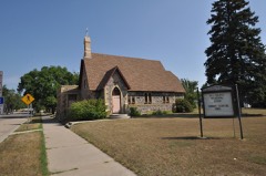 | All Saints' Episcopal Church | building | 1992 | 92001605 |
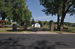 | Amphitheater and Fieldstone WPA Features at Valley City Pioneer Park | object | 2011 | 10001195 |
 | Barnes County Courthouse | building | 1985 | 85002978 |
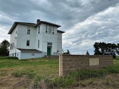 | Green Consolidated School | building | 2011 | 11000768 |
| Ladbury Church | building | 2005 | 05001140 | |
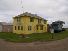 | Midland Continental Railroad Depot | building | 2003 | 03000870 |
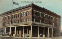 | Rudolf Hotel | building | 1983 | 83001926 |
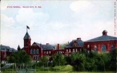 | State Normal School at Valley City Historic District | district | 1995 | 95000049 |
 | US Post Office-Valley City | building | 1989 | 89001758 |
 | Valley City Carnegie Library | building | 1979 | 79003724 |
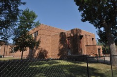 | Valley City Municipal Auditorium | building | 2008 | 07001341 |
 | West Park Bridge | structure | 1997 | 97000169 |
Every wildfire the federal occurrence database records inside this county: 82 of them, burning about 2,951 acres. 2 started naturally and none was recorded as arson. Each settlement page carries the fires within five miles of it.
| Reported cause | Fires |
|---|---|
| Debris and open burning | 42 |
| Equipment and vehicle use | 16 |
| Smoking | 10 |
| Missing data/not specified/undetermined | 7 |
| Railroad operations and maintenance | 4 |
| Natural | 2 |
| Fireworks | 1 |
The five largest, by the area the report gives. None of them was recorded as arson.
| Date | Cause | Size | Reported by | Name on the report |
|---|---|---|---|---|
| 17 May 2008 | Missing data/not specified/undetermined | 1,000 acres | North Dakota State Forest Service | COLIN CONLEY |
| 16 May 2008 | Missing data/not specified/undetermined | 500 acres | North Dakota State Forest Service | 18 |
| 23 April 2015 | Natural | 375 acres | North Dakota State Forest Service | DOUGLAS HARLAND |
| 18 April 2005 | Missing data/not specified/undetermined | 150 acres | North Dakota State Forest Service | not named |
| 26 October 2001 | Debris and open burning | 129 acres | Valley City Wetland Management District | BLIKRE |
| 15 August 2015 | Equipment and vehicle use | 100 acres | North Dakota State Forest Service | GAME & FISH |
| 7 October 2000 | Debris and open burning | 90 acres | Valley City Wetland Management District | KNUDTSON |
| 4 August 2005 | Equipment and vehicle use | 80 acres | North Dakota State Forest Service | not named |
Every settlement page carries the fires within five miles of it - see the settlement index below.
The NOAA Storm Events Database holds 607 reports for this county, causing no deaths, 1 injury and about $9,818,250 in recorded property damage. Each settlement page carries the reports that name it.
| Kind of event | Reports |
|---|---|
| Hail | 331 |
| Thunderstorm Wind | 171 |
| Tornado | 66 |
| Flash Flood | 17 |
| Flood | 8 |
| Funnel Cloud | 8 |
| Lightning | 4 |
| Heavy Rain | 2 |
The most serious of them, by death, then injury, then recorded damage. The accounts are quoted exactly as the forecast office filed them.
| When | Event | Place named | Harm | What the report says |
|---|---|---|---|---|
| June 1965 | Tornado (F2) | not stated | 1 hurt, $25,000 | no account filed |
| July 2004 | Tornado (F4) | Litchville | $1,700,000 | The tornado tracked south for about 4 miles along 97th avenue southeast, then turned to the southeast and tracked about 6 more miles before it crossed into LaMoure county about 2 miles north-northwest of Marion. One abandoned farmstead 10 miles west-northwest of Litchville was nearly swept clean of its buildings. Eight to nine buildings and 5 to 6 metal grain bins were swept away. At an occupied farmstead about 9 miles west of Litchville, the most damage was reported. The family was out baling hay at the time and were not hurt. The equipment they used to bale hay (three tractors and a baler) were the only things left unscathed by the tornado. Two houses, 5 outbuildings, a cattle barn, and miscellaneous farm equipment were all leveled. Machinery and debris were scattered across the yard and in the nearby pond and fields. A new pickup truck was demolished and sheet metal and metal support beams were wrapped around trees and vehicles. About 35 cows were killed, 20 grain bins were demolished, and a semi truck was overturned. The last F4 tornado in eastern North Dakota occurred on June 6, 1999, near Mountain, ND. |
| June 2003 | Thunderstorm Wind | Valley City | $1,400,000 | Eighteen 80 foot tall 345 kV high voltage power transmission towers were blown down in several sections to the Cass county line. A section of Highway 32 north of Oriska was briefly closed where the wires fell on the road. |
| July 2010 | Tornado (EF2) | Sibley | $1,000,000 | Several grain bins were lofted for a mile or more and destroyed. Large pine trees were uprooted and numerous trees were stripped of leaves and branches. Equipment storage buildings were unroofed and otherwise flattened to the ground. The tornado tracked continuously for at 14 to 15 miles. There was also widespread wind and hail damage observed in the area. |
| July 2011 | Tornado (EF1) | Valley City Arpt | $750,000 | A tornado was briefly viewed wrapped in heavy rains as it approached the northeast corner of Valley City. The tornado became entirely wrapped in heavy rains and downburst winds as it tracked for about three miles across northern portions of Valley City. Numerous large tree limbs and branches were broken down around town. Peak winds were estimated at 95 mph. The downburst winds affected a much wider path. |
| June 2007 | Flood | Valley City | $500,000 | Several rural roads were closed due to high water levels. There were 38 of 42 townships which reported damage to culverts, roadbeds, and driveways. Standing or flowing water through fields led to extreme crop stress and direct crop loss on about 5000 acres. |
| July 2007 | Thunderstorm Wind | Fingal | $500,000 | One steel four pole power tower was crumpled and numerous trees were snapped off. Additional towers in adjacent Cass County were also destroyed. Wind driven hail also caused crop damage in Springvale and Binghampton Townships. |
| June 2003 | Thunderstorm Wind | Peak | $400,000 | Large 30,000 bushel steel grain bins at the Peak elevator complex were crushed by the wind. Numerous large trees were also blown down and augers were twisted and broken. |
| August 2001 | Thunderstorm Wind | Fingal | $250,000 | Many trees and powerlines were blown down and several roofs were damaged. |
| June 1998 | Flash Flood | Valley City | $250,000 | no account filed |
| July 1982 | Tornado (F1) | not stated | $250,000 | no account filed |
| June 1979 | Tornado (F1) | not stated | $250,000 | no account filed |
| June 1977 | Tornado (F1) | not stated | $250,000 | no account filed |
| August 1974 | Tornado (F2) | not stated | $250,000 | no account filed |
| August 1968 | Tornado (F3) | not stated | $250,000 | no account filed |
| August 1955 | Tornado (F2) | not stated | $250,000 | no account filed |
| June 2017 | Thunderstorm Wind | Koldok | $200,000 | Multiple vehicles were blown off Interstate 94, which briefly closed. |
| June 2013 | Flash Flood | Valley City | $200,000 | Very heavy rains produced widespread street flooding around Valley City. Power outages and rapid runoff also combined to produce flooding of storm drains and sewer backup issues. At least four homes had partially collapsed basement walls. About 6.30 inches of rain fell over a two to three hour period. |
| July 2001 | Thunderstorm Wind | Valley City | $150,000 | Large trees were uprooted around Lake Ashtabula, falling on cars, decks, and houses. Boats, pontoons, jet skis, and boat lifts were also damaged. |
| June 2003 | Thunderstorm Wind | Oriska | $100,000 | 7 large grain bins were damaged at the Evergreen Farmers Cooperative. |
| September 1997 | Thunderstorm Wind | Fingal | $100,000 | The strong wind destroyed three grain bins, ripped the doors off a machine shed, and caused roof damage to the farm buildings. A new grain auger was also destroyed. |
| August 2001 | Lightning | Valley City | $75,000 | A lightning strike caused a fire which destroyed a home. |
| August 1997 | Lightning | Litchville | $60,000 | Lightning struck the roof of a house, quickly igniting the second story of the house. The upstairs level was destroyed, with the rest of the house sustaining smoke and water damage. |
| June 2008 | Thunderstorm Wind | Hastings | $50,000 | An old granary was thrown fifty feet, and the wind knocked down two to three inch diameter branches down. |
| August 1999 | Lightning | Rogers | $50,000 | A 2 story building in Rogers caught fire and burned down after getting hit by lightning. |
| July 1999 | Thunderstorm Wind | Valley City | $50,000 | A camper and several tents were overturned at Bald Hill Dam Campground. One tent, with the 2 occupants inside, was picked up by the wind and carried a short distance away. Several docks were destroyed and several boats were pushed on shore. |
| August 1993 | Hail | Rogers | $50,000 | no account filed |
| September 2017 | Tornado (EF1) | Litchville | $30,000 | The tornado peeled shingles and roofing off of homes at two farmsteads roughly a mile apart, and snapped or uprooted several box-elder and spruce trees at both farmsteads. Branch scatter through a shelterbelt located midway between the farms suggested a possible secondary vortex. Peak winds were estimated at 110 mph. |
| July 2002 | Thunderstorm Wind | Oriska | $30,000 | A semi truck was blown off Interstate 94. The truck was not carrying any cargo. |
| August 2011 | Flash Flood | Pillsbury | $25,000 | Several sections of farmland and farm access roads were flooded across Ellsbury Township. |
| July 1988 | Tornado (F0) | not stated | $25,000 | no account filed |
| June 1983 | Tornado (F1) | not stated | $25,000 | no account filed |
| June 1977 | Tornado (F0) | not stated | $25,000 | no account filed |
| June 1976 | Tornado | not stated | $25,000 | no account filed |
| July 1967 | Tornado (F1) | not stated | $25,000 | no account filed |
| September 1965 | Tornado (F2) | not stated | $25,000 | no account filed |
| May 2013 | Thunderstorm Wind | Peak | $20,000 | A semi-truck was blown over on Interstate 94 near mile point 295. |
| June 2008 | Tornado (EF0) | Koldok | $20,000 | A tornado tracked intermittently for about 4 miles and crossed into Cass County about 2 miles north of Tower City by 739 pm CDT. It then continued for about one more mile before it lifted about 2 miles northeast of Tower City by 741 pm CDT. A few large branches were broken down in shelterbelts. Peak winds were estimated at 80 mph. |
| August 1994 | Thunderstorm Wind | Fingal | $20,000 | no account filed |
| May 2013 | Thunderstorm Wind | Koldok | $15,000 | A semi-truck was flipped over by strong winds. |
| August 2001 | Thunderstorm Wind | Valley City | $15,000 | The strong wind blew trees and powerlines down, knocking out power to 25 percent of the city. The most wind damage was near Valley City State University. |
| August 2011 | Flood | Pillsbury | $10,000 | Overland flooding continued near Pillsbury after three to six inches of rain fell. |
| September 2008 | Lightning | Valley City | $10,000 | Lightning struck an office building and started a fire in the attic. |
| June 2008 | Thunderstorm Wind | Rogers | $10,000 | Large three to four inch diameter branches were knocked down by the wind. |
| July 2001 | Thunderstorm Wind | Dazey | $10,000 | A powerline was blown down. |
| July 1999 | Tornado (F0) | Litchville | $10,000 | Two homes were damaged by a tornado northwest of Litchville. One home had quite a few shingles blown off. The second home had part of its roof torn off. Several rafters and a third of the shingles were blown off. Most of the insulation in the attic was sucked out. |
| July 1999 | Thunderstorm Wind | Valley City | $10,000 | A mobile home was overturned at Martin's Landing. |
| May 1996 | Thunderstorm Wind | Valley City | $10,000 | no account filed |
| June 2013 | Flash Flood | Rogers | $5,000 | The observer at Baldhill Dam measured 3.10 inches of rain in a short amount of time. Roads near the dam were quickly covered with water and debris. Farmyards and fields in the area also experienced localized flooding. |
| May 2010 | Flood | Pillsbury | $5,000 | Water continued to flow over North Dakota highway 32 in multiple locations where local creeks contribute to the Maple River. |
| August 1999 | Tornado (F1) | Litchville | $5,000 | The tornado began south and west of Litchville, travelling mostly through open country before it crossed briefly into Lamoure county. It then crossed into Ransom county, where it dissipated north of Lisbon. |
| March 2009 | Flood | Frazier | $5,000 | no account filed |
| April 2009 | Flood | Frazier | $5,000 | no account filed |
| August 1994 | Tornado (F0) | Fingal | $5,000 | no account filed |
| September 1997 | Flash Flood | Valley City | $3,000 | Heavy rain fell west of Valley City, closing the westbound lane of Interstate 94 at Hobart Lake. Prior to the closure, several cars stalled in the water. |
| June 1971 | Tornado (F0) | not stated | $2,500 | no account filed |
| August 1970 | Tornado (F1) | not stated | $2,500 | no account filed |
| May 1965 | Tornado | not stated | $2,500 | no account filed |
| June 1964 | Tornado (F1) | not stated | $2,500 | no account filed |
| August 1964 | Tornado (F1) | not stated | $2,500 | no account filed |
The Survey's mineral resources record lists 2 workings inside this county. 1 still produces and 1 is closed or unrecorded. Each settlement page carries the workings within five miles of it.
| Commodity | Workings |
|---|---|
| Sand and Gravel, Construction | 2 |
The least common of them first, because a county's hundredth gravel pit says nothing its first ten did not.
| Where | Site | Commodity | Status | Recorded |
|---|---|---|---|---|
| Goeller Pit | Sand and Gravel, Construction | Producer | ||
| Valley City State Pit | Sand and Gravel, Construction | Past Producer |
Named settlements recorded in the Geographic Names Information System, each with the topographic sheets covering it. Villages, hamlets and abandoned places alike. Each is shown with the nearest named watercourse or landform and the survey quadrangle it falls on.
Ashtabula township · 58479 · On Baldhill Creek · Dazey NE quadrangle
8 sheets, 1952 to 1985
No longer a settlement
Binghampton township · 58031 · Lucca quadrangle
10 sheets, 1897 to 1989
No longer a settlement
The vanished settlements of Barnes County: the places named above that are no longer on the map.