 Block
From the record
3 National Register listings published here.
Sources: the National Register database, National Park Service
25 topographic sheets cover 14 settlements here, and 3 properties are on the National Register of Historic Places.
3 National Register listings published here.
Sources: the National Register database, National Park Service
Every property in this county listed on the National Register of Historic Places, with the year it was listed and the federal nomination document.
| Photograph | Property | Type | Listed | Reference |
|---|---|---|---|---|
| Hutmacher Farm | district | 1979 | 79001772 | |
| Independence Congregational Church | building | 2015 | 15000422 | |
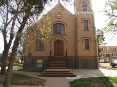 | Saints Peter and Paul Church | building | 1986 | 86000161 |
Every wildfire the federal occurrence database records inside this county: 224 of them, burning about 15,772 acres. 93 started naturally and 5 were recorded as arson. Each settlement page carries the fires within five miles of it.
| Reported cause | Fires |
|---|---|
| Natural | 93 |
| Equipment and vehicle use | 29 |
| Missing data/not specified/undetermined | 24 |
| Debris and open burning | 23 |
| Fireworks | 15 |
| Power generation/transmission/distribution | 10 |
| Misuse of fire by a minor | 9 |
| Smoking | 5 |
| Recreation and ceremony | 5 |
| Arson/incendiarism | 5 |
| Other causes | 5 |
| Firearms and explosives use | 1 |
The five largest, by the area the report gives. None of them was recorded as arson.
| Date | Cause | Size | Reported by | Name on the report |
|---|---|---|---|---|
| 19 September 2012 | Missing data/not specified/undetermined | 9,500 acres | Fort Berthold Agency | LITTLE SWALLOW |
| 6 November 2009 | Missing data/not specified/undetermined | 1,580 acres | Fort Berthold Agency | SQUAW CREEK |
| 3 April 2016 | Natural | 640 acres | Fort Berthold Agency | ROUGH |
| 30 October 2011 | Missing data/not specified/undetermined | 600 acres | Fort Berthold Agency | LONE FIGHT |
| 22 April 2008 | Equipment and vehicle use | 477 acres | Fort Berthold Agency | YOUNGBEAR |
| 24 November 1995 | Equipment and vehicle use | 383 acres | Fort Berthold Agency | FOX FIRE |
| 8 April 2010 | Missing data/not specified/undetermined | 300 acres | Fort Berthold Agency | FACE |
| 8 June 2013 | Debris and open burning | 200 acres | North Dakota State Forest Service | ALEY COUNTY 20 |
Every settlement page carries the fires within five miles of it - see the settlement index below.
The NOAA Storm Events Database holds 309 reports for this county, causing no deaths, 3 injuries and about $26,531,500 in recorded property damage. Each settlement page carries the reports that name it.
| Kind of event | Reports |
|---|---|
| Hail | 166 |
| Thunderstorm Wind | 99 |
| Tornado | 24 |
| Flood | 7 |
| Funnel Cloud | 7 |
| Flash Flood | 4 |
| Heavy Rain | 2 |
The most serious of them, by death, then injury, then recorded damage. The accounts are quoted exactly as the forecast office filed them.
| When | Event | Place named | Harm | What the report says |
|---|---|---|---|---|
| July 2016 | Hail | Killdeer | 2 hurt, $20,000,000 | A slow moving supercell resulted in an extended period of very large hail and damaging wind gusts in and around the city of Killdeer. Hail up to 3.25 inches in diameter completely covered the ground in many locations. The hail combined with wind gusts of 75 mph to cause extreme damage to buildings, trees, and vehicles in the city. At the Killdeer nursing home windows were broken out and four rooms were damaged to the point where they were not habitable. Two residents sustained minor injuries. The first was injured (direct injury) when they were struck by broken flying glass. The other person was injured (direct injury) as they were evacuating their living area due to broken windows and fell on a wet floor as rain and hail were pouring in. Every field light at the new football stadium was destroyed, and every bus at the school was significantly damaged. Significant damage occurred to vehicles including those at a dealership. |
| September 2014 | Thunderstorm Wind | Dunn Center | 1 hurt, $300,000 | Minor injuries occurred to a 9 year old female that was inside a 5th wheel trailer-camper that tipped over. A horse trailer nearby also tipped over. Farm outbuildings and fences were damaged and trees were snapped. There was speculation that the damage could have been caused by a tornado, but determination from photo evidence was that this damage was caused by very high straight line thunderstorm winds. |
| September 2014 | Hail | Manning | $2,000,000 | There was very significant damage to buildings and automobiles including at a car dealership. |
| August 2014 | Flood | Killdeer | $1,700,000 | Upwards of 10.50 inches of rain in parts of Dunn County led to very significant overland flooding. There was also flooding along the Knife River and its tributaries. There was significant damage to roads and crops. A county emergency declaration was issued. |
| April 2023 | Flood | Killdeer | $540,000 | Flooding from snow melt runoff caused significant damages to county infrastructure. |
| July 2017 | Thunderstorm Wind | Halliday | $275,000 | Multiple power poles were snapped in and around the community of Halliday. |
| June 2018 | Tornado (EF2) | Killdeer | $175,000 | This was the second of two tornadoes in Dunn County this day. The earlier tornado hit nothing and so was rated EF0. This second tornado was rated EF2. It initially struck a mobile home shortly after it touched down, completely destroying the structure. Based on that damage the tornado at this location was EF2. From that EF2 rating the winds were estimated at 125 mph. No one was home at the time so there were no injuries or deaths at this location. The tornado then proceeded generally northward to a farmstead, where a stock trailer was flipped, a truck was pushed 200 yards through a fence, and an old out-building was completely destroyed. At the farm the damage corresponded to EF1. There were no injuries or deaths as all on the farm reached safety before the tornado struck. The tornado then continued to the north until it dissipated. The overall tornado rating is EF2. |
| July 2013 | Thunderstorm Wind | Killdeer | $175,000 | There were multiple reports of up to eight inch in diameter trees snapped around Killdeer. A hanger at the Killdeer airport was destroyed, with several planes damaged or destroyed. |
| July 2013 | Hail | Halliday | $105,000 | The large hail damaged vehicles and homes in the city of Halliday. |
| June 2021 | Thunderstorm Wind | Manning | $100,000 | A cellular phone tower was blown down. |
| July 2013 | Thunderstorm Wind | Halliday | $80,000 | Severe thunderstorm winds tipped over campers, took power lines down, and ripped siding from several homes in Halliday. |
| August 1999 | Thunderstorm Wind | Manning | $80,000 | Damage to a 50 foot high water tank. |
| July 2025 | Thunderstorm Wind | Marshall | $75,000 | A garage was destroyed by the thunderstorm winds. |
| July 2016 | Thunderstorm Wind | Marshall | $75,000 | Trees were blown down and a barn sustained damage. |
| June 2010 | Thunderstorm Wind | Killdeer | $70,000 | Trees and power lines were reported down from the intense thunderstorm winds. In addition, a roof was partially torn off of the Buckskin Bar and Grill and an exterior sign was blown off of another building in Killdeer. Damage was also sustained to other buildings, along with two lightning related fires. |
| March 2009 | Flood | Killdeer | $70,000 | Overland flooding damaged state, county and township roads. The Knife River was also in flood. No homes were flooded. |
| July 2018 | Tornado (EF1) | Dodge | $60,000 | A tornado formed on the east edge of Dodge, near Spring Creek, and traveled southeast crossing Highway 200 before moving into a farmstead. Two outbuildings were destroyed, some trees were snapped, and crops were damaged. No injuries or deaths occurred. The damage corresponded to EF1 and from that winds were estimated to have been around 97 mph. This was the first of two tornadoes, minutes apart and from the same parent thunderstorm, in Dunn County this day. |
| May 2011 | Flood | Killdeer | $50,000 | See the event episode narrative for details. |
| August 1993 | Hail | Halliday | $50,000 | no account filed |
| July 2010 | Hail | Halliday | $45,000 | Hail up to two inches in diameter was observed in Halliday. Reports of crop damage were received, along with broken windows in Halliday. |
| July 1997 | Thunderstorm Wind | Halliday | $40,000 | report came from a woman that had a digital wind recorder on her farm 1 W of Halliday. Numerous trees downed as fell as extensive damage to farm and out buildings. A tractor-trailer was blown through a fence. |
| August 2011 | Hail | Emerson | $35,000 | The large hail resulted in broken windows and damage to a vehicle. |
| July 2016 | Hail | Werner | $30,000 | Siding on a house was damaged. |
| July 2012 | Hail | New Hradec | $30,000 | The large hail damaged crops, homes, and vehicles. |
| July 2016 | Hail | Killdeer | $30,000 | no account filed |
| July 2013 | Thunderstorm Wind | Emerson | $25,000 | The strong winds caused tree damage. |
| July 2012 | Hail | Killdeer | $25,000 | The large hail dented cars and damaged shingles on a home. |
| June 1990 | Tornado (F0) | not stated | $25,000 | no account filed |
| June 1986 | Tornado (F0) | not stated | $25,000 | no account filed |
| July 1982 | Tornado (F1) | not stated | $25,000 | no account filed |
| June 1980 | Tornado (F1) | not stated | $25,000 | no account filed |
| June 1980 | Tornado (F1) | not stated | $25,000 | no account filed |
| May 1978 | Tornado (F2) | not stated | $25,000 | no account filed |
| June 2016 | Hail | Killdeer | $20,000 | no account filed |
| July 2012 | Hail | Killdeer | $15,000 | The very large hail damaged a patrol car. |
| April 2010 | Thunderstorm Wind | Halliday | $15,000 | Tree damage from thunderstorm winds was reported near Halliday. |
| September 1997 | Thunderstorm Wind | Halliday | $15,000 | strong winds moved into Mahto Bay on Lake Sakakawea. Numerous cabins had roofs torn off. There were also some that had decks damaged from falling tree branches. A few boats were capsized or flipped over from the high winds. |
| August 2023 | Thunderstorm Wind | Halliday | $10,000 | A window on a truck was broken out and a snowmobile trailer was blown down into a coulee. |
| June 2018 | Flash Flood | Halliday | $10,000 | A slow moving thunderstorm produced torrential rain over eastern Dunn County and western Mercer County. Over five inches of rain fell over some locations causing creeks to come out of their banks and overland flooding to develop. Deep water was running across North Dakota Highway 8. The water damaged crops. |
| July 2016 | Thunderstorm Wind | Werner | $10,000 | Large tree branches were broken around the marina at McKenzie Bay. |
| June 2015 | Thunderstorm Wind | Killdeer | $10,000 | Several large trees were downed. |
| July 2011 | Flash Flood | Werner | $10,000 | There were two reports of very heavy rain from northern Dunn County. One was 1.24 inches in 25 minutes about 10 miles northeast of Dunn Center and the other was 1.50 inches in 45 minutes from about 6 miles north-northeast of Killdeer. Reports of flash flooding of low lying and poor drainage areas were received. Damage was not significant. |
| July 1997 | Thunderstorm Wind | Dodge | $10,000 | Strong winds occurred 4 NE of Dodge. The wind tore the tin off of a pole barn, then blew the tin 400 yds away. |
| May 2018 | Hail | Marshall | $5,000 | Windows were broken by the hail. |
| July 2010 | Thunderstorm Wind | Emerson | $5,000 | Estimated winds of 60 mph resulted in some minor tree damage. |
| July 2008 | Thunderstorm Wind | Halliday | $3,000 | High winds blew down a sixty foot tall tree on the north side of Halliday. |
| July 2008 | Thunderstorm Wind | Halliday | $2,000 | High winds knocked down a six inch in diameter tree. |
| June 2022 | Hail | Marshall | $1,000 | Hail chipped paint off window sills. |
| July 1979 | Tornado (F0) | not stated | $250 | no account filed |
| July 1965 | Tornado | not stated | $250 | no account filed |
| July 2024 | Tornado (EFU) | Emerson | - | The tornado touched down in an open field south of Manning and impacted no structures. There was no damage to evaluate. By National Weather Service policy the tornado is rated EF-U (Unknown). |
| August 2023 | Thunderstorm Wind | Killdeer | - | Thunderstorm wind gusts were estimated by the public. |
| August 2020 | Thunderstorm Wind | New Hradec | - | Thunderstorm wind gusts were estimated by the public. |
| July 2019 | Thunderstorm Wind | Manning | - | The public reported thunderstorm wind gusts to 65 mph. |
| May 2018 | Thunderstorm Wind | Marshall | - | A COOP Observer estimated a thunderstorm wind gust of 60 mph. |
| May 2018 | Tornado (EF0) | Emerson | - | The tornado occurred over rural locations northwest of Hirschville. No damage occurred, therefore the tornado was rated EF0. |
| July 2018 | Tornado (EF0) | Dodge | - | The tornado formed south of Dodge and passed over a recently tilled field, which made it visible 45 miles away. About 35 hay bales were displaced. There was no other damage. The tornado was rated EF0 with estimated wind speeds around 80 mph. This was the second of two tornadoes, minutes apart and from the same parent thunderstorm, in Dunn County this day. |
| June 2018 | Tornado (EF0) | Killdeer | - | This was the first of two tornadoes in Dunn County this day. This tornado remained in an open field. No damage occurred and so it was rated EF0. A second tornado in Dunn County later this day was rated EF2. |
| June 2016 | Thunderstorm Wind | Manning | - | Wind speed was estimated by the public. |
| June 2015 | Tornado (EF0) | Emerson | - | This tornado was reported by law enforcement to have basically touched the ground and almost immediately lift back into the parent thunderstorm. There was no damage and no structures were impacted, so the rating is EF0. |
The Survey's mineral resources record lists 1 working inside this county. It is closed or unrecorded. Each settlement page carries the workings within five miles of it.
| Commodity | Workings |
|---|---|
| Sand and Gravel, Construction | 1 |
The least common of them first, because a county's hundredth gravel pit says nothing its first ten did not.
| Where | Site | Commodity | Status | Recorded |
|---|---|---|---|---|
| Jablonski Pit | Sand and Gravel, Construction | Past Producer |
Named settlements recorded in the Geographic Names Information System, each with the topographic sheets covering it. Villages, hamlets and abandoned places alike. Each is shown with the nearest named watercourse or landform and the survey quadrangle it falls on.
South Dunn unorganized territory · 58630 · Hirschville quadrangle
7 sheets, 1953 to 1974
Killdeer unorganized territory · 58642 · On Wolf Creek · Manning quadrangle
7 sheets, 1953 to 1974
Killdeer unorganized territory · 58640 · Killdeer Mountains quadrangle
7 sheets, 1953 to 1974
South Dunn unorganized territory · 58601 · New Hradec South quadrangle
5 sheets, 1953 to 1981
Fort Berthold unorganized territory · 58636 · Twin Buttes quadrangle
7 sheets, 1953 to 1982