 Block
From the record
4 National Register listings published here.
Sources: the National Register database, National Park Service
21 topographic sheets cover 11 settlements here, and 4 properties are on the National Register of Historic Places.
4 National Register listings published here.
Sources: the National Register database, National Park Service
Every property in this county listed on the National Register of Historic Places, with the year it was listed and the federal nomination document.
| Photograph | Property | Type | Listed | Reference |
|---|---|---|---|---|
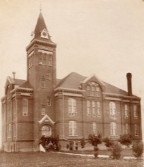 | Griggs County Courthouse | building | 1977 | 77001025 |
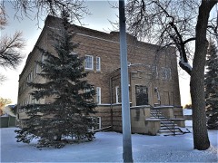 | Northern Lights Masonic Lodge | building | 1987 | 87001775 |
 | Oscar-Zero Missile Alert Facility | building | 2008 | 08000994 |
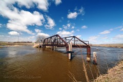 | Romness Bridge | structure | 1997 | 97000179 |
Every wildfire the federal occurrence database records inside this county: 24 of them, burning about 1,374 acres. None started naturally and none was recorded as arson. Each settlement page carries the fires within five miles of it.
| Reported cause | Fires |
|---|---|
| Debris and open burning | 15 |
| Missing data/not specified/undetermined | 5 |
| Equipment and vehicle use | 3 |
| Power generation/transmission/distribution | 1 |
The five largest, by the area the report gives. None of them was recorded as arson.
| Date | Cause | Size | Reported by | Name on the report |
|---|---|---|---|---|
| 24 April 2019 | Debris and open burning | 700 acres | North Dakota State Forest Service | SHAUN ADRIAN |
| 13 April 2008 | Missing data/not specified/undetermined | 300 acres | North Dakota State Forest Service | MATT HELM |
| 12 April 2016 | Debris and open burning | 200 acres | North Dakota State Forest Service | SAXBERG-EBERHARDT |
| 7 May 2019 | Debris and open burning | 50 acres | North Dakota State Forest Service | SCOTT LARSON PLOT |
| 26 April 2019 | Debris and open burning | 20 acres | North Dakota State Forest Service | PAINTNER FIRE |
| 31 August 2012 | Debris and open burning | 20 acres | North Dakota State Forest Service | RUSTEN |
| 31 August 2012 | Equipment and vehicle use | 15 acres | North Dakota State Forest Service | TAFELMEYER-VIG CRP |
| 20 July 2012 | Equipment and vehicle use | 15 acres | North Dakota State Forest Service | BRANDON WALL STRAW BALER |
Every settlement page carries the fires within five miles of it - see the settlement index below.
The NOAA Storm Events Database holds 319 reports for this county, causing no deaths, 1 injury and about $18,126,980 in recorded property damage. Each settlement page carries the reports that name it.
| Kind of event | Reports |
|---|---|
| Hail | 159 |
| Thunderstorm Wind | 96 |
| Tornado | 37 |
| Funnel Cloud | 13 |
| Flash Flood | 7 |
| Flood | 5 |
| Heavy Rain | 2 |
The most serious of them, by death, then injury, then recorded damage. The accounts are quoted exactly as the forecast office filed them.
| When | Event | Place named | Harm | What the report says |
|---|---|---|---|---|
| August 1997 | Hail | Cooperstown | 1 hurt, $5,000,000 | The hail began near Jessie, cut a 3 by 12 mile long swath of damage, and ended 3 miles south of Cooperstown. The hail lasted for 15 minutes in Cooperstown, breaking windows, and damaging homes and businesses. One car dealership sustained $400,000 worth of damages. 20,000 acres of crops were destroyed, the equivalent of 20 farms. A 15 year-old girl, driving in the storm, suffered minor cuts due to flying glass. One hailstone recovered near Cooperstown measured 4 by 7 inches. |
| August 2006 | Thunderstorm Wind | Cooperstown | $9,060,000 | Thunderstorm downburst winds funneled down the Sheyenne River Valley and blew numerous double-stack containers and BNSF railroad container cars off the south side of the Luverne Trestle Bridge. At least 76 containers were destroyed after plunging up to 150 feet into the valley below. The bridge is located about 2 miles west of Luverne. Peak winds were estimated at 85 mph. |
| June 1986 | Tornado (F2) | not stated | $2,500,000 | no account filed |
| June 1994 | Tornado (F0) | Binford | $500,000 | A severe thunderstorm, which spawned a tornado, funnel clouds, and waterspouts, passed near a Bible Camp. Trees were destroyed and power lines downed. Strong winds from the storm caused a pickup and camper, with three passengers, to roll over on its side. There were no injuries reported. |
| July 1987 | Tornado (F3) | not stated | $250,000 | no account filed |
| July 1987 | Tornado (F0) | not stated | $250,000 | no account filed |
| June 1986 | Tornado (F2) | not stated | $250,000 | no account filed |
| June 1999 | Thunderstorm Wind | Cooperstown | $100,000 | The front of a barn was blown off, a machine shed was destroyed, and a garage was toppled onto 2 vehicles inside. Some debris was scattered more than a mile away. |
| August 2011 | Flash Flood | Cooperstown | $25,000 | Several sections of farmland and farm access roads were flooded across portions of Sverdrup and Broadview townships. |
| June 1971 | Tornado (F2) | not stated | $25,000 | no account filed |
| July 1957 | Tornado (F3) | not stated | $25,000 | no account filed |
| June 1999 | Thunderstorm Wind | Cooperstown | $20,000 | A barn was blown down by the wind. A dozen sheep inside the barn were killed. |
| June 1999 | Thunderstorm Wind | Shepard | $20,000 | A small recreational vehicle was pushed more than 30 feet, crushing it. |
| August 2008 | Hail | Hannaford | $20,000 | no account filed |
| July 2011 | Tornado (EF1) | Revere | $10,000 | The tornado knocked down several trees in various shelterbelts along its route. At one farmstead several sheets of steel roofing were ripped up and tossed off of a shed and numerous tree branches were scattered about. Peak winds were estimated at 95 mph. |
| August 2011 | Flood | Cooperstown | $10,000 | Overland flooding continued east and southeast of Cooperstown after 3 to 6 inches of rain fell. |
| June 1999 | Thunderstorm Wind | Cooperstown | $10,000 | Tree branches were blown down on city streets. One tree landed on top of a recreational vehicle. |
| May 2010 | Flash Flood | Hannaford | $5,000 | Heavy rains of three to five inches produced flooding in fields and across a few low lying roads. |
| August 2008 | Thunderstorm Wind | Hannaford | $5,000 | Several large 3 to 5 inch diameter tree branches were blown down. |
| July 2001 | Flash Flood | Cooperstown | $5,000 | The city park was flooded and water was 2 feet deep on streets downtown. |
| August 2001 | Hail | Revere | $5,000 | Hailstones damaged a pickup and the siding on a house and broke a window. |
| July 1999 | Thunderstorm Wind | Cooperstown | $5,000 | Trees and power lines were downed. |
| March 2009 | Flood | Mose | $5,000 | no account filed |
| April 2009 | Flood | Mose | $5,000 | no account filed |
| August 2001 | Hail | Revere | $4,000 | Windows were broken and the siding on a home was damaged. |
| August 2001 | Thunderstorm Wind | Cooperstown | $3,000 | Branches were blown down. |
| August 1990 | Tornado (F0) | not stated | $2,500 | no account filed |
| July 2002 | Thunderstorm Wind | Cooperstown | $2,000 | Trees were blown down in Cooperstown. |
| September 2017 | Tornado (EF0) | Cooperstown | $1,000 | This tornado tracked intermittently for about two miles across a portion of the Sheyenne River Valley. Large tree branches were broken down in various shelterbelts and groves along the path, mainly along the valley edge. Peak winds were estimated at 75 mph. |
| August 2002 | Thunderstorm Wind | Cooperstown | $500 | Large tree branches were blown off. |
| August 2001 | Thunderstorm Wind | Hannaford | $500 | Branches were blown down. |
| August 2001 | Thunderstorm Wind | Cooperstown | $500 | Branches were blown down. |
| July 2001 | Thunderstorm Wind | Cooperstown | $500 | Branches were blown down. |
| August 2001 | Thunderstorm Wind | Binford | $500 | Branches were blown down. |
| July 2001 | Thunderstorm Wind | Hannaford | $500 | Tree branches were blown down. |
| June 1999 | Thunderstorm Wind | Binford | $500 | Large trees were blown down in the strong wind. |
| June 1999 | Thunderstorm Wind | Binford | $500 | no account filed |
| June 1983 | Tornado (F0) | not stated | $250 | no account filed |
| August 2002 | Thunderstorm Wind | Cooperstown | $200 | Tree limbs were blown down. |
| July 1982 | Tornado (F0) | not stated | $30 | no account filed |
| June 2025 | Hail | Binford | - | Report of quarter size hail. |
| August 2025 | Tornado (EF0) | Mose | - | This brief tornado developed about 1.7 miles west of Red Willow Lake and caused damage to crops. High resolution satellite imagery reveals ground scouring and crop damage along the short narrow path. Time estimated from KMVX radar. Maximum wind is estimated at 70 mph. |
| August 2025 | Tornado (EF1) | Revere | - | This QLCS tornado was likely rain wrapped with the starting location approximated based on high resolution satellite imagery with scouring occurring in a wheat field. The tornado moved to the northeast and destroyed a 120 ft by 60 ft pole barn. Max estimated wind is 110 mph. |
| June 2025 | Thunderstorm Wind | Cooperstown | - | NDAWN station 2W of Cooperstown reported a wind gust of 63 mph. Mesonet station 321766 Cooperstown ND NDAWN. |
| June 2025 | Thunderstorm Wind | Sutton | - | Personal weather station via Weather Underground, I.D. Ramsey Farm - KNDBINFO8. Measured gust to 71 mph. Duration of severe gusts 40 minutes. Highest sustained wind 67 mph. Extreme wind gusts associated with MCV on backside of derecho. |
| June 2025 | Thunderstorm Wind | Cooperstown | - | Personal weather station via Weather Underground, I.D. Ronald Reagan Minuteman Missile SHS - KNDCOOPE6. Measured gust to 59 mph. Duration of severe gusts 15 minutes. Extreme wind gusts associated with MCV on backside of derecho. |
| June 2025 | Thunderstorm Wind | Cooperstown | - | NDAWN station 2W of Cooperstown measured a 72 mph wind gust at the 10 meter sensor. Mesonet station 321766 Cooperstown ND NDAWN. |
| July 2025 | Thunderstorm Wind | Jessie | - | Multiple tree branches down and one large tree down. |
| June 2024 | Hail | Binford | - | Quarter sized hail reported in Binford, ND. |
| June 2024 | Thunderstorm Wind | Cooperstown Arpt | - | Cooperstown AWOS reports 59 mph gust. |
| June 2023 | Hail | Cooperstown | - | Public reports quarter sized hail covering the ground. |
| June 2023 | Thunderstorm Wind | Cooperstown Arpt | - | Automated weather station at airport in Cooperstown, ND. |
| June 2022 | Thunderstorm Wind | Sutton | - | Received a report of a 59 mph wind gust measured at a personal weather station. |
| June 2022 | Thunderstorm Wind | Cooperstown | - | Received a wind report of 58 mph as measured from a personal weather station. |
| June 2022 | Thunderstorm Wind | Revere | - | Received a report of a 72 mph wind gust as measured from a personal weather station. |
| June 2022 | Thunderstorm Wind | Jessie | - | Received a report of a 68 mph wind gust as measured on a personal weather station. Location was 4 miles NW of Cooperstown. |
| June 2022 | Thunderstorm Wind | Jessie | - | Received a public report of an uprooted tree via social media. |
| June 2022 | Thunderstorm Wind | Sutton | - | A few large 4 to 6 inch diameter tree branches broken down, along with dime to nickel size hail. |
| July 2022 | Thunderstorm Wind | Hannaford | - | Peak wind was measured at a personal weather station. |
| September 2022 | Hail | Walum | - | Public reports quarter-sized hail. Time estimated by radar. |
Named settlements recorded in the Geographic Names Information System, each with the topographic sheets covering it. Villages, hamlets and abandoned places alike. Each is shown with the nearest named watercourse or landform and the survey quadrangle it falls on.
Washburn township · 58425 · Cooperstown East quadrangle
9 sheets, 1952 to 1985
No longer a settlement
Greenfield township · 58448 · On Gunderson Creek · Hannaford quadrangle
8 sheets, 1952 to 1985
The vanished settlements of Griggs County: the places named above that are no longer on the map.