 Block
From the record
8 National Register listings published here.
Sources: the National Register database, National Park Service
60 topographic sheets cover 19 settlements here, and 8 properties are on the National Register of Historic Places.
8 National Register listings published here.
Sources: the National Register database, National Park Service
Every property in this county listed on the National Register of Historic Places, with the year it was listed and the federal nomination document.
| Photograph | Property | Type | Listed | Reference |
|---|---|---|---|---|
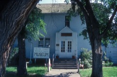 | Former McLean County Courthouse | building | 1985 | 85002987 |
| Fort Buford Stage Road | site | 2019 | 100004540 | |
| Fort Buford Stage Road | site | 2019 | 100004540 | |
| Freborg Homestead | building | 2014 | 14000625 | |
 | Holy Trinity Ukrainian Greek Orthodox Church | building | 1982 | 82001344 |
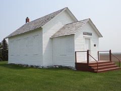 | Ingersoll School | building | 2010 | 10000139 |
| Semevolos Farm | building | 1987 | 87001788 | |
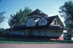 | Soo Line Depot | building | 1978 | 78003079 |
Every wildfire the federal occurrence database records inside this county: 332 of them, burning about 10,876 acres. 73 started naturally and 16 were recorded as arson. Each settlement page carries the fires within five miles of it.
| Reported cause | Fires |
|---|---|
| Debris and open burning | 74 |
| Natural | 73 |
| Missing data/not specified/undetermined | 52 |
| Equipment and vehicle use | 47 |
| Fireworks | 35 |
| Misuse of fire by a minor | 18 |
| Arson/incendiarism | 16 |
| Recreation and ceremony | 6 |
| Smoking | 5 |
| Other causes | 3 |
| Power generation/transmission/distribution | 2 |
| Railroad operations and maintenance | 1 |
The five largest, by the area the report gives. None of them was recorded as arson.
| Date | Cause | Size | Reported by | Name on the report |
|---|---|---|---|---|
| 4 April 2006 | Debris and open burning | 1,764 acres | Audubon National Wildlife Refuge | RIVERDALE WOODS/DOWNSTREAM |
| 23 August 2003 | Natural | 1,500 acres | North Dakota State Forest Service | WILTON |
| 3 November 2007 | Equipment and vehicle use | 1,008 acres | Audubon National Wildlife Refuge | ROBINSON SUNFLOWER |
| 4 September 1998 | Natural | 800 acres | Fort Berthold Agency | SHEPPERD |
| 4 May 2008 | Missing data/not specified/undetermined | 700 acres | North Dakota State Forest Service | CLARENCE HANSON |
| 11 August 2006 | Natural | 320 acres | Fort Berthold Agency | BILLADEAU |
| 4 May 2000 | Natural | 300 acres | Fort Berthold Agency | IRWIN FIRE |
| 8 May 2008 | Debris and open burning | 257 acres | Fort Berthold Agency | SIMONSON |
Every settlement page carries the fires within five miles of it - see the settlement index below.
The NOAA Storm Events Database holds 555 reports for this county, causing 1 death, 16 injuries and about $15,412,280 in recorded property damage. Each settlement page carries the reports that name it.
| Kind of event | Reports |
|---|---|
| Hail | 277 |
| Thunderstorm Wind | 200 |
| Tornado | 47 |
| Funnel Cloud | 14 |
| Lightning | 6 |
| Flash Flood | 6 |
| Flood | 5 |
The most serious of them, by death, then injury, then recorded damage. The accounts are quoted exactly as the forecast office filed them.
| When | Event | Place named | Harm | What the report says |
|---|---|---|---|---|
| June 2018 | Thunderstorm Wind | Mercer | 1 killed, 4 hurt, $250,000 | About 30 camping trailers at Heckers Lake and New Johns Lake were damaged and destroyed, with many overturned. Some of the campers came to rest in the water. One fatality occurred at Heckers Lake as an individual was outside his camper, and the camper blew over onto him. Four injuries were also reported in the camping areas|around New Johns and Heckers Lakes. |
| May 1975 | Tornado (F2) | not stated | 5 hurt, $25,000 | no account filed |
| July 2007 | Tornado (EF1) | Roseglen | 4 hurt, $80,000 | NWS storm survey was completed for this event. An EF1 tornado was confirmed to have occurred on the Fort Berthold Reservation of Mclean County starting from 6 miles south of White Shield and ending 8 miles south-southeast of White Shield. The path was about 1 1/2 miles long. One manufactured home was rolled and badly damaged near the beginning of the path. It had three occupants, one adult male and one adult female approximately in their 30's, and one four year old child. All three had minor injuries. A pickup truck at this location was totally destroyed as the home rolled onto it and the truck acted as a stop. Another manufactured home was completely destroyed about one mile from the first. It had one adult male occupant, age 53, who was seriously injured and hospitalized. There was also significant damage to crops in the area, with 100 percent crop loss in some fields caused by wind driven hail up to 1.5 inches in diameter. Wind speed estimated 105 mph. |
| July 2006 | Thunderstorm Wind | Coleharbor | 2 hurt, $3,000,000 | A National Weather Service storm damage survey was completed 0715 CST to 1500 CST the day following the event, July 13, 2006. NWS meteorologist was accompanied by the Mclean County Emergency Manager. Damage was extensive and severe. Nearly every building in the town of about 80 people was damaged. The degree of damage varied with heavier damage to structures and trees on the west side of the town, including to a school built in 1916 and used until the mid 1960s. Just across highway 83, on the west side of town, an empty railroad coal car was off the tracks and on its side. The structural and tree damage pattern, coupled with comments from eye witnesses and 88D RADAR data, led to the determination that the event was a wet microburst with wind speeds in excess of 100 mph. Storms were multicellular in structure. Witnesses described a shelf cloud approaching, followed by the high wind, and then very heavy rain. There were two very minor injuries and no fatalities. The two injuries were in a camper that was rolled by the wind and destroyed. Coleharbor covers an area about 1/4 mile by 1/4 mile. Damage covered an area just under 4 km or just under 2 1/2 miles on a side. Outside of town the damage included a barn, many trees, and moved straw or hay bales. The ND Department of Transportation had weather instrumentation along highway 83 on the west side of Coleharbor. The Environmental Sensor Station had an engineered wind resistance of 120 mph and was lying on the ground following the storm. See photo. See entry for Mclean County 1 E Coleharbor 1828 CST to 1837 CST July 12, 2006. |
| July 2010 | Hail | Emmet | 1 hurt, $45,000 | Large hail was reported at the Triangle Y Camp, resulting in damage to vehicles. One person was injured when a hailstone struck the person's foot. |
| June 2011 | Flood | Riverdale | $5,000,000 | See the event episode narrative for details. |
| August 2006 | Thunderstorm Wind | Washburn | $675,000 | Significant damage to a grain elevator, one home, and a few vehicles in Falkirk, ND. |
| August 2023 | Thunderstorm Wind | Roseglen | $500,000 | Significant damage occurred in White Shield and the surrounding area. Homes had vinyl siding damaged by wind driven hail. Vehicle windshields along with windows in homes were broken. In White Shield, four campers were blown over. |
| July 2015 | Thunderstorm Wind | Underwood | $500,000 | Thunderstorm wind gust speed was based on damage photos. Multiple roofs were damaged. Large trees were snapped and uprooted, and one tree landed on a car and crushed it. Various other vehicles were damaged by falling trees and limbs. A camper was overturned. |
| June 2018 | Thunderstorm Wind | Mercer | $350,000 | Extensive wind damage occurred in the Brush Lake and Mercer areas. Multiple metal sheds were blown over and boating docks were damaged. Large trees at Brush Lake were snapped and uprooted. Multiple campers were heavily damaged. |
| April 2009 | Flood | Raub | $350,000 | Heavy overland flooding occurred as the result of rapid runoff from snowmelt. Flooding damaged many county and township roads along with 35 homes. |
| September 2025 | Tornado (EF1) | Mercer | $300,000 | The tornado touched down about a mile west of Mercer near a farmstead which it then passed through. At this farmstead, the tornado caused extensive tree damage to the property with many branches and trees snapped, and a large tree uprooted. The tornado then partially destroyed a pole barn by ripping about one-half of the rafters off, and pulling out several large support beams along its southeast side that were buried about five feet deep. Debris was scattered up to one-quarter mile away, with large pieces of wood embedded in the ground along the debris field. From there, the tornado then crossed Highway 200, damaging trees on the north side of the highway. It then proceeded north and destroyed an unanchored and unoccupied mobile home on wheels being stored about six miles north of Mercer. The tornado then lifted about two miles north of the mobile home damage. Based on the damage done this tornado was rated EF-1, and from that wind speeds were estimated to be around 110 mph. |
| June 1999 | Flash Flood | Garrison | $300,000 | six (6) inches rain fell in a three (3) hour period resulting in widespread flooding. flood waters reached 3 to 8 feet impacting 115 homes and business property. |
| August 2022 | Tornado (EF2) | Ruso | $250,000 | This was the third of three tornadoes this day in McLean County, all near Ruso and in less than a one hour period of time. The tornado formed in an open field and approached a farmstead, passing just to the west and south of it. Near the farmstead the tornado destroyed three small wooden granaries, flipped a large seed cart attached to an air seeder, flipped anhydrous ammonia tanks, and tossed hay bales. The tornado continued on south of the farmstead where it tossed multiple hay bales before dissipating. Based on the damage done the tornado was rated EF-2, with winds estimated to be approximately 120 MPH. |
| June 1987 | Tornado (F0) | not stated | $250,000 | no account filed |
| May 1977 | Tornado (F1) | not stated | $250,000 | no account filed |
| May 1974 | Tornado (F0) | not stated | $250,000 | no account filed |
| March 2009 | Flood | Raub | $205,000 | Overland flooding damaged many county and township roads. Thirty five homes were flooded. Flooding continued into April. |
| August 2024 | Thunderstorm Wind | Turtle Lake | $200,000 | Multiple trees were uprooted at Crooked Lake. Small sheds were destroyed, fences were blown down, and pontoons were flipped and some damaged. |
| August 2006 | Tornado (F2) | Underwood | $200,000 | This low end F2 tornado, on the order of 120 mph, produced considerable damage to a farm house and outbuildings 9 miles southwest of Underwood. The attached garage was completely torn from the two story house, and the roofing materials were also torn away, leaving the trusses visible. One detached shop, garden shed, and well house were destroyed. Items from the property were found 1/2 mile away. Nearby power lines were down. National Weather Service personnel conducted storm surveys of the area on two different days. |
| July 2024 | Thunderstorm Wind | Roseglen | $150,000 | The strong thunderstorm wind gusts combined with golf ball size hail to cause property and crop damage in the White Shield area. |
| July 2020 | Thunderstorm Wind | Washburn | $150,000 | Many trees were blown down in the park along the river in Washburn, at the 4-H camp, and throughout the city. The concession stand and outhouses were blown over at the baseball park. Some buildings were damaged. |
| June 2018 | Thunderstorm Wind | Falkirk | $150,000 | Half of a metal outbuilding on a farm was torn off. About ten wooden power poles in the vicinity were broken. |
| June 2016 | Thunderstorm Wind | Roseglen | $150,000 | A mobile home rolled onto its side. Other mobile homes in the area were also damaged. |
| July 2015 | Hail | Garrison Muni Arpt | $150,000 | no account filed |
| June 2018 | Thunderstorm Wind | Underwood | $110,000 | A large swath of power poles along Highway 85 were snapped. |
| June 2020 | Thunderstorm Wind | Turtle Lake | $100,000 | Multiple barns were blown down by the thunderstorm wind gusts, with debris scattered a good distance away from the original location. |
| July 2011 | Thunderstorm Wind | Max | $100,000 | Large hail accompanied the strong winds with damage to roofs and windows. Trees in Max were damaged. |
| July 2010 | Thunderstorm Wind | Garrison | $100,000 | The strong winds combined with large hail resulting in extensive damage in and around the city of Garrison. Damage was sustained to a building under construction west of Garrison, several trees being uprooted, a railroad crossing twisted off, and crop damage reported to fields south and southwest of Garrison. |
| August 2006 | Thunderstorm Wind | Turtle Lake | $80,000 | Two barns destroyed. Trees snapped and uprooted. |
| July 1996 | Tornado (F1) | Mercer | $75,000 | no account filed |
| August 1996 | Lightning | 4 Ne Garrison | $70,000 | no account filed |
| June 2005 | Flash Flood | Max | $60,000 | no account filed |
| August 2024 | Thunderstorm Wind | Turtle Lake | $50,000 | Three large grain bins were partially caved in by the thunderstorm wind gusts. |
| June 2018 | Thunderstorm Wind | Washburn | $50,000 | Multiple trees and power lines were down. |
| July 2011 | Lightning | Garrison | $50,000 | Lightning struck the roof of a house at rural Garrison and started a fire. Damage was significant. The time, location, and damage value are estimated as these details were not provided in the article. |
| July 2010 | Hail | Emmet | $50,000 | The large hail was accompanied by 50 mph winds at Camp of the Cross. Damage was sustained to vehicles along with broken windows on a chapel. |
| May 2006 | Thunderstorm Wind | Wilton | $50,000 | Trees blown down and roof blown off pole barn. |
| June 2009 | Hail | Turtle Lake | $45,000 | Residents of rural Turtle Lake reported window damage to homes and vehicles from the large hail. |
| July 2020 | Thunderstorm Wind | Garrison Muni Arpt | $40,000 | The roof of a home was severely damaged. |
| June 2018 | Flash Flood | Roseglen | $40,000 | Over seven inches of rain fell in the Roseglen and White Shield areas. This led to water flowing through the lower areas of these communities. Damage was described as minor and confined to a few basements. The terrain, very hilly, allowed water to flow into lower areas where there were few if any structures, and away from buildings. |
| July 2008 | Hail | Emmet | $35,000 | Very large hail up to tennis ball size damaged skylights on a home and caused other damage. |
| July 2007 | Thunderstorm Wind | Raub | $35,000 | Winds collapsed a cabin being constructed at the Indian Hills Recreation Area. |
| August 2024 | Thunderstorm Wind | Turtle Lake | $30,000 | A center pivot irrigation system was flipped over and damaged. |
| July 1997 | Thunderstorm Wind | Turtle Lake | $30,000 | Strong winds destroyed a pole barn and garage 5 N Turtle Lake |
| August 2022 | Tornado (EF1) | Ruso | $25,000 | This was the second of three tornadoes this day in McLean County, all near Ruso and in less than a one hour period of time. Hardwood trees were snapped and an animal shelter was destroyed shortly after development. Based on the damage done the tornado was rated EF-1, with winds estimated to be approximately 110 MPH. |
| July 2008 | Flash Flood | Garrison | $25,000 | Flash flooding was reported in the city of Garrison with water flooding city streets and yards, and flowing into some basements. This was due to excessive rainfall of 3.43 inches total, with 2.62 inches of that falling within one hour. |
| June 1989 | Tornado (F1) | not stated | $25,000 | no account filed |
| July 1986 | Tornado (F1) | not stated | $25,000 | no account filed |
| July 1966 | Tornado (F1) | not stated | $25,000 | no account filed |
| June 1956 | Tornado (F3) | not stated | $25,000 | no account filed |
| August 2021 | Hail | Emmet | $20,000 | Multiple vehicles were damaged. A canola crop was severely damaged. |
| July 2020 | Thunderstorm Wind | Turtle Lake | $20,000 | Many trees were damaged in the area. |
| July 2018 | Thunderstorm Wind | Wilton | $20,000 | Large trees were uprooted in the city of Wilton. |
| July 2010 | Thunderstorm Wind | Mercer | $20,000 | Trees four to five inches in diameter were blown down. |
| June 1996 | Thunderstorm Wind | Garrison | $20,000 | no account filed |
| August 2011 | Thunderstorm Wind | Mercer | $18,000 | Several trees were snapped or uprooted. |
| September 2015 | Thunderstorm Wind | Underwood | $15,000 | A partially build garage was damaged by the strong winds. |
| July 2012 | Thunderstorm Wind | Garrison | $15,000 | Several trees were uprooted by the strong winds. |
| July 2006 | Lightning | Coleharbor | $15,000 | 75 year old barn was struck by lightning, caught fire, and was destroyed. |
The Survey's mineral resources record lists 8 workings inside this county. 5 still produce and 3 are closed or unrecorded. Each settlement page carries the workings within five miles of it.
| Commodity | Workings |
|---|---|
| Sand and Gravel, Construction | 8 |
The least common of them first, because a county's hundredth gravel pit says nothing its first ten did not.
| Where | Site | Commodity | Status | Recorded |
|---|---|---|---|---|
| Fisher Sand & Gravel Was | Sand and Gravel, Construction | Unknown | ||
| Fishers Keen Pit | Sand and Gravel, Construction | Producer | ||
| Lindteigen Const Co Pit | Sand and Gravel, Construction | Producer | ||
| Missouri River Sand &Gravel Co Pit | Sand and Gravel, Construction | Producer | ||
| Mountrail County Pit | Sand and Gravel, Construction | Past Producer | ||
| Olson Pit | Sand and Gravel, Construction | Unknown | ||
| Whites Underwood Pit | Sand and Gravel, Construction | Producer | ||
| Wilton Pit | Sand and Gravel, Construction | Producer |
Named settlements recorded in the Geographic Names Information System, each with the topographic sheets covering it. Villages, hamlets and abandoned places alike. Each is shown with the nearest named watercourse or landform and the survey quadrangle it falls on.
South McLean unorganized territory · 58577 · On Turtle Creek (historical) · Sanger quadrangle
8 sheets, 1950 to 1979
Underwood unorganized territory · 58565 · On Aggie Brown Coulee · Riverdale South quadrangle
7 sheets, 1948 to 1972
Underwood unorganized territory · 58576 · Underwood quadrangle
8 sheets, 1949 to 1961
Fort Berthold unorganized territory · 58775 · Blackwater Lake quadrangle
6 sheets, 1954 to 1958