 Block
From the record
4 National Register listings published here.
Sources: the National Register database, National Park Service
40 topographic sheets cover 19 settlements here, and 4 properties are on the National Register of Historic Places.
4 National Register listings published here.
Sources: the National Register database, National Park Service
Every property in this county listed on the National Register of Historic Places, with the year it was listed and the federal nomination document.
| Photograph | Property | Type | Listed | Reference |
|---|---|---|---|---|
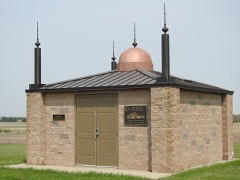 | Assyrian Muslim Cemetery | site | 2018 | 100002693 |
 | Great Northern Railway Underpass | structure | 1997 | 97000182 |
 | Mountrail County Courthouse | building | 1978 | 78001992 |
 | Wabek Consolidated School | building | 2019 | 100004541 |
Every wildfire the federal occurrence database records inside this county: 584 of them, burning about 17,266 acres. 145 started naturally and 30 were recorded as arson. Each settlement page carries the fires within five miles of it.
| Reported cause | Fires |
|---|---|
| Natural | 145 |
| Equipment and vehicle use | 99 |
| Debris and open burning | 93 |
| Missing data/not specified/undetermined | 87 |
| Fireworks | 52 |
| Power generation/transmission/distribution | 33 |
| Arson/incendiarism | 30 |
| Recreation and ceremony | 15 |
| Misuse of fire by a minor | 10 |
| Railroad operations and maintenance | 8 |
| Smoking | 8 |
| Other causes | 4 |
The five largest, by the area the report gives. None of them was recorded as arson.
| Date | Cause | Size | Reported by | Name on the report |
|---|---|---|---|---|
| 9 September 2005 | Missing data/not specified/undetermined | 6,500 acres | Lostwood Wetland Management District | CLEAR LAKE |
| 14 August 2007 | Missing data/not specified/undetermined | 2,180 acres | Fort Berthold Agency | MUSKRAT LAKE |
| 13 March 2016 | Equipment and vehicle use | 900 acres | North Dakota State Forest Service | DEMICK LAKE |
| 4 September 1998 | Natural | 700 acres | Fort Berthold Agency | JONHSON |
| 25 April 2007 | Debris and open burning | 360 acres | Fort Berthold Agency | RISAN |
| 18 May 2002 | Debris and open burning | 360 acres | Lostwood Wetland Management District | HD JOHNSON |
| 24 September 2012 | Natural | 350 acres | Fort Berthold Agency | BAKER COULEE |
| 3 April 1993 | Debris and open burning | 310 acres | Lostwood Wetland Management District | C.PRAIRIE |
Every settlement page carries the fires within five miles of it - see the settlement index below.
The NOAA Storm Events Database holds 409 reports for this county, causing no deaths, 2 injuries and about $3,687,530 in recorded property damage. Each settlement page carries the reports that name it.
| Kind of event | Reports |
|---|---|
| Hail | 188 |
| Thunderstorm Wind | 144 |
| Tornado | 31 |
| Funnel Cloud | 25 |
| Flood | 8 |
| Flash Flood | 7 |
| Heavy Rain | 5 |
| Lightning | 1 |
The most serious of them, by death, then injury, then recorded damage. The accounts are quoted exactly as the forecast office filed them.
| When | Event | Place named | Harm | What the report says |
|---|---|---|---|---|
| June 1958 | Tornado (F2) | not stated | 2 hurt, $25,000 | no account filed |
| June 2014 | Flood | White Earth | $254,000 | Flooding occurred over Mountrail County. Damage occurred to roads and culverts with many wash outs along township roads. There was crop damage as well. Rain amounts ranged from 2.50 inches in Bottineau County to as much as 7.00 inches in Renville County. |
| July 2016 | Hail | New Town Arpt | $250,000 | A slow moving supercell thunderstorm produced hail up to two inches in diameter along with wind gusts to 60 mph in and near the city of New Town. |
| June 1990 | Tornado (F1) | not stated | $250,000 | no account filed |
| June 1979 | Tornado (F1) | not stated | $250,000 | no account filed |
| May 1977 | Tornado (F1) | not stated | $250,000 | no account filed |
| April 2009 | Flood | White Earth | $216,000 | Overland flooding resulted in damage to local and county roads. |
| March 2009 | Flood | White Earth | $186,000 | Overland flooding damaged state, county and township roads. No homes were flooded. Flooding continued into April. |
| July 2014 | Hail | New Town | $175,000 | Numerous work trucks in the New Town area had windows broken due to the wind driven golf ball size hail. There was also crop damage. |
| July 2016 | Thunderstorm Wind | New Town | $150,000 | A pickup-truck pulling a camper and boat was blown into the guard rail on Four Bears Bridge. Also, a metal roof blew off an industrial building. |
| July 2016 | Thunderstorm Wind | Sanish | $150,000 | A grain bin was blown off its foundation and into a wheat field. |
| April 2023 | Flood | Tagus | $110,000 | Flooding from snow melt runoff caused significant damages to county infrastructure. |
| August 2023 | Thunderstorm Wind | Sanish | $100,000 | The end tower of an irrigation pivot was blown over and extensive crop damage occurred. |
| June 2021 | Thunderstorm Wind | New Town | $100,000 | Multiple mature trees were blown over, with some being 30 to 40 feet in height. Some power lines were damaged. |
| July 2016 | Thunderstorm Wind | New Town | $100,000 | Severe thunderstorm wind gusts caused a camper to overturn into a ditch near the intersection of North Dakota Highways 8 and 23. |
| June 2011 | Flash Flood | Plaza | $100,000 | Heavy rainfall in excess of four inches in one hour resulted in flash flood conditions near and north of Plaza. Area roads were reported to be flooded. |
| August 2010 | Thunderstorm Wind | Parshall | $80,000 | Large hail accompanied the strong thunderstorm winds. The wind driven hail resulted in broken windows to area homes and some crop damage. |
| June 2012 | Thunderstorm Wind | Plaza | $75,000 | The strong winds blew down several telephone poles. |
| July 2013 | Flash Flood | New Town | $65,000 | Heavy runoff from thunderstorms resulted in a flash flood in the city of New Town. Water was a few feet deep in town and running into buildings. |
| August 2010 | Hail | Parshall | $65,000 | The large hail resulted in broken windows to mobile homes. |
| July 2025 | Thunderstorm Wind | Parshall Arpt | $50,000 | Two camper trailers were blown over at Parshall Bay Recreational Area. |
| June 2020 | Thunderstorm Wind | Sanish | $50,000 | Twenty five power poles were either damaged, broken, or leaning. At one point 1,300 electrical meters were without power. |
| May 2011 | Flood | Sanish | $50,000 | See the event episode narrative for details. |
| August 2010 | Thunderstorm Wind | New Town | $50,000 | Large hail accompanied the strong thunderstorm winds. Powerlines were reported down along with a carport blown over. |
| July 2024 | Tornado (EF1) | Belden | $40,000 | The tornado touched down at a farmstead where multiple campers were parked. One camper was overturned and destroyed, and a small metal grain bin had its roof torn off. The tornado then proceeded into an open field with no other structures impacted. Based on the damage done the tornado was rated EF-1, with winds estimated to be approximately 90 MPH. |
| July 2007 | Thunderstorm Wind | Stanley | $40,000 | Spotter reports several trees down in the city of Stanley. Largest tree was approximately 16 inches in diameter. Two flag poles also broken off. |
| June 2010 | Thunderstorm Wind | Parshall | $35,000 | The peak wind speed was estimated from numerous reports of tree damage in the Parshall area. |
| June 2010 | Thunderstorm Wind | Stanley | $35,000 | Severe thunderstorm winds damaged the rafters on a machine storage building. The building was under construction with only the frame of the building finished. Time of the event was based on radar. |
| August 2007 | Thunderstorm Wind | Plaza | $30,000 | Dickinson Press reports two large grain bins and grain augers blown over on farm west of Plaza. There was also crop damage as the storms were accompanied by small hail that was wind driven. |
| June 2012 | Thunderstorm Wind | Palermo | $25,000 | The strong winds blew down a pole barn. |
| July 2009 | Thunderstorm Wind | Stanley | $25,000 | Trained weather spotters reported damage from the severe thunderstorm wind gusts. A small metal building was reported blown into a ditch, numerous tree branches were blown down, and one window was reported blown out of a trailer home. |
| August 2006 | Thunderstorm Wind | Stanley | $25,000 | Carport damaged. Also, debris struck a nearby building and damaged the upper part near the roof. Vehicle damage reported as well. The peak severe wind gust episode at 822 PM CST appeared to be caused by the thunderstorm collapsing. |
| June 1980 | Tornado (F1) | not stated | $25,000 | no account filed |
| July 1970 | Tornado (F1) | not stated | $25,000 | no account filed |
| July 1965 | Tornado | not stated | $25,000 | no account filed |
| July 1955 | Tornado (F4) | not stated | $25,000 | no account filed |
| July 2025 | Thunderstorm Wind | Parshall | $20,000 | A camper was blown over. |
| June 2011 | Flash Flood | White Earth | $20,000 | Slow moving and redeveloping thunderstorms brought heavy rain to the area. Excessive runoff from the heavy rain resulted in flash flood conditions to develop. |
| July 2011 | Flash Flood | New Town | $20,000 | Very heavy rain resulted in an estimated one foot of water on Main Street in New Town. Water was in yards of homes and in some cases where there was no curbing the water was up against the homes. |
| June 2020 | Thunderstorm Wind | Sanish | $15,000 | A large machine shed had its metal doors pushed in and damaged by the strong winds. |
| June 2010 | Hail | Parshall | $14,000 | The large hail was accompanied with strong thunderstorm winds. The wind driven hail resulted in damage to vehicles and to a screen door window. |
| June 2012 | Flash Flood | Parshall | $10,000 | Very heavy rainfall of up to six inches fell in and around the Parshall area. Water was reported to be flowing over Highway 37 south of Parshall. |
| June 2016 | Hail | Sanish | $10,000 | no account filed |
| July 1996 | Lightning | Stanley | $10,000 | no account filed |
| June 2016 | Thunderstorm Wind | Lostwood | $8,000 | A trained spotter reported that two power poles were down. |
| July 2011 | Thunderstorm Wind | Stanley | $8,000 | The strong winds destroyed a baseball dugout and snapped a ten inch in diameter tree. |
| July 2011 | Thunderstorm Wind | Parshall | $8,000 | The strong winds lasted a few minutes. |
| July 2024 | Thunderstorm Wind | Plaza | $5,000 | Large tree branches were blown down. |
| June 2020 | Thunderstorm Wind | Sanish | $5,000 | Numerous tree branches larger than six inches in diameter were broken. |
| July 2013 | Thunderstorm Wind | New Town | $5,000 | Tree branches three inches in diameter were blown down in New Town. |
| July 2011 | Thunderstorm Wind | Stanley | $5,000 | A tree that was two and one half feet in diameter, and 30 feet tall, was snapped. |
| June 2007 | Thunderstorm Wind | Parshall | $5,000 | Large branches broken on trees. |
| June 2021 | Thunderstorm Wind | Stanley | $3,000 | Six inch diameter branches from a one-hundred year old tree were broken down. |
| July 2014 | Thunderstorm Wind | Sanish | $3,000 | Large hail accompanied the strong winds. Damage was not significant. |
| July 1980 | Tornado (F1) | not stated | $2,500 | no account filed |
| July 1971 | Tornado (F1) | not stated | $2,500 | no account filed |
| June 1962 | Tornado (F2) | not stated | $2,500 | no account filed |
| July 1982 | Tornado (F0) | not stated | $30 | no account filed |
| July 2024 | Thunderstorm Wind | Blaisdell | - | The public reported thunderstorm wind gusts of 65 mph. |
| July 2024 | Thunderstorm Wind | New Town Arpt | - | The public estimated thunderstorm wind gusts of 60 mph. |
The Survey's mineral resources record lists 7 workings inside this county. 1 still produces and 6 are closed or unrecorded. Each settlement page carries the workings within five miles of it.
| Commodity | Workings |
|---|---|
| Sand and Gravel, Construction | 6 |
| Sodium | 1 |
The least common of them first, because a county's hundredth gravel pit says nothing its first ten did not.
| Where | Site | Commodity | Status | Recorded |
|---|---|---|---|---|
| Unknown | Sodium | Unknown | ||
| Anderson Pit | Sand and Gravel, Construction | Unknown | ||
| Arnstad Pit and Plant | Sand and Gravel, Construction | Producer | ||
| Loock Pit | Sand and Gravel, Construction | Unknown | ||
| Mountrail County Pit | Sand and Gravel, Construction | Unknown | ||
| Rambel Pit | Sand and Gravel, Construction | Unknown | ||
| Rudolph Pit | Sand and Gravel, Construction | Unknown |
Named settlements recorded in the Geographic Names Information System, each with the topographic sheets covering it. Villages, hamlets and abandoned places alike. Each is shown with the nearest named watercourse or landform and the survey quadrangle it falls on.
White Earth city · 58794 · On Paulsen Creek · White Earth quadrangle
4 sheets, 1953 to 1969