 Block
From the record
2 National Register listings published here.
Sources: the National Register database, National Park Service
19 topographic sheets cover 12 settlements here, and 2 properties are on the National Register of Historic Places.
2 National Register listings published here.
Sources: the National Register database, National Park Service
Every property in this county listed on the National Register of Historic Places, with the year it was listed and the federal nomination document.
| Photograph | Property | Type | Listed | Reference |
|---|---|---|---|---|
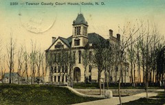 | Towner County Courthouse | building | 1985 | 85002996 |
| Towner County Fairgrounds Pavilion | building | 2024 | 100010912 |
Every wildfire the federal occurrence database records inside this county: 63 of them, burning about 3,646 acres. 1 started naturally and 10 were recorded as arson. Each settlement page carries the fires within five miles of it.
| Reported cause | Fires |
|---|---|
| Missing data/not specified/undetermined | 24 |
| Debris and open burning | 20 |
| Arson/incendiarism | 10 |
| Equipment and vehicle use | 4 |
| Fireworks | 2 |
| Natural | 1 |
| Misuse of fire by a minor | 1 |
| Other causes | 1 |
The five largest, by the area the report gives. One of them was set deliberately.
| Date | Cause | Size | Reported by | Name on the report |
|---|---|---|---|---|
| 5 May 2016 | Missing data/not specified/undetermined | 500 acres | North Dakota State Forest Service | GRASS FIRE |
| 18 May 2016 | Debris and open burning | 400 acres | North Dakota State Forest Service | BROMBERG FIRE |
| 24 October 2007 | Arson/incendiarism | 373 acres | Devil's Lake Wetland Management District | NORTH ROCK LAKE |
| 6 June 2002 | Missing data/not specified/undetermined | 350 acres | Turtle Mountain Agency | JUMBO |
| 22 October 2015 | Missing data/not specified/undetermined | 350 acres | North Dakota State Forest Service | WEST DARREL MANNING |
| 24 May 2002 | Debris and open burning | 340 acres | Devil's Lake Wetland Management District | KOCH |
| 13 April 2016 | Debris and open burning | 227 acres | Devil's Lake Wetland Management District | NIKOLIASON |
| 16 April 2012 | Debris and open burning | 140 acres | Devil's Lake Wetland Management District | AMBLE |
Every settlement page carries the fires within five miles of it - see the settlement index below.
The NOAA Storm Events Database holds 281 reports for this county, causing no deaths, no injuries and about $1,043,700 in recorded property damage. Each settlement page carries the reports that name it.
| Kind of event | Reports |
|---|---|
| Hail | 154 |
| Thunderstorm Wind | 68 |
| Tornado | 32 |
| Flood | 9 |
| Flash Flood | 8 |
| Funnel Cloud | 7 |
| Heavy Rain | 3 |
The most serious of them, by death, then injury, then recorded damage. The accounts are quoted exactly as the forecast office filed them.
| When | Event | Place named | Harm | What the report says |
|---|---|---|---|---|
| June 1996 | Thunderstorm Wind | Rock Lake | $300,000 | no account filed |
| April 2006 | Flood | Countywide | $294,000 | Due to the quick snowmelt, water quickly drained into low areas, damaging around 40 roads and 40 bridges around the county. State Highway 66 had water over the road east of Egeland. Towner County received a Presidential Disaster Declaration for damages caused by spring flooding. |
| July 2008 | Tornado (EF1) | Crocus | $150,000 | This tornado produced an intermittent damage path of nearly 11 total miles, and ended about one mile north-northeast of Munich in Cavalier County by 428 pm CDT. The tornado only traveled about 5 miles due east in Towner County and mainly damaged crops and power lines. The tornado crossed into Cavalier County around 418 pm CDT at a point about 4 miles north and 6 miles east of Egeland. Peak wind speeds were estimated at 100 mph. |
| June 2008 | Hail | Hansboro | $50,000 | Hail fell for nearly five minutes near the Cavalier County line along with strong winds. Several sections of crop land recieved damage in Dash and Lansing Townships. |
| March 2017 | Flood | Hansboro | $50,000 | no account filed |
| April 2017 | Flood | Hansboro | $50,000 | no account filed |
| June 1994 | Thunderstorm Wind | Minot | $50,000 | no account filed |
| August 2016 | Flash Flood | Bisbee Lyster Arpt | $15,000 | Highway 66 was closed due to water flowing across the road. Fields and ditches were flooded across Grainfield, Sorenson, New City, and Gerrard townships. |
| July 2008 | Hail | Bisbee Lyster Arpt | $15,000 | Hard rain with hail and strong winds lasted for about ten minutes. |
| July 2008 | Hail | Rocklake | $10,000 | The large hail fell near the Cavalier County line. |
| June 1996 | Hail | Cando | $10,000 | no account filed |
| August 2010 | Flash Flood | Egeland | $5,000 | Street flooding was reported in Egeland. |
| July 2008 | Tornado (EF3) | Armourdale | $5,000 | This tornado originated in Rolette County, where it produced EF3 damage near Rolla. It continued into Towner County for about 3 more miles and lifted about 11 miles west-northwest of Rock Lake. It produced mainly EF1 damage to scattered trees and fields in Towner County. Peak winds in Towner County were estimated at 90 mph. |
| August 2008 | Thunderstorm Wind | Bisbee | $5,000 | Several large 5 to 7 inch diameter branches were blown down in a shelterbelt. |
| August 2002 | Thunderstorm Wind | Cando | $5,000 | A 140x18.5 foot wall on the city newspaper building was blown down. |
| May 2013 | Flood | Hansboro | $5,000 | no account filed |
| April 2013 | Flood | Hansboro | $5,000 | no account filed |
| March 2009 | Flood | Hansboro | $5,000 | no account filed |
| April 2009 | Flood | Hansboro | $5,000 | no account filed |
| July 1965 | Tornado (F0) | not stated | $2,500 | no account filed |
| June 1965 | Tornado | not stated | $2,500 | no account filed |
| August 2021 | Tornado (EF1) | Newville | $2,000 | This tornado tracked from northeast Coolin Township into east-central Klingstrup Township. It snapped or uprooted several large cottonwood trees at farmsteads and shelterbelts along its path. |
| June 2000 | Thunderstorm Wind | Cando | $1,000 | Trees were blown down in Cando. |
| August 2000 | Thunderstorm Wind | Hansboro | $1,000 | The door on a pole barn was torn off by the strong wind. |
| June 2001 | Thunderstorm Wind | Cando | $500 | Large tree branches were blown down. |
| August 2002 | Thunderstorm Wind | Hansboro | $200 | Branches were blown down. |
| August 2025 | Hail | Hansboro | - | Hail estimated in size. Significant crop damage occurred in near mature wheat and soybeans. |
| July 2025 | Tornado (EF0) | Newville | - | A large dusty tornado was reported near Calio ND with no damage conveyed from any sources who witnessed it. This tornado started in Towner County and traveled 0.50 miles to the Cavalier county line, where it traveled an additional 1.04 miles. It is suspected that this was spawned out of land spout processes which likely contributed to its dusty tubelike appearance as seen on social media. UPDATE 7/22/25: Adjusted track based on Sentinel-2 satellite imagery. |
| September 2025 | Hail | Bisbee | - | Estimated hail size with a few stones up to one inch in size. |
| June 2023 | Hail | Cando | - | Public reports quarter sized hail mixed in with smaller stones in Cando. Brief duration. |
| June 2023 | Thunderstorm Wind | Rocklake | - | NDAWN measurement from 6 south-southwest Rocklake. |
| August 2022 | Thunderstorm Wind | Rocklake | - | Peak wind measured at an NDAWN station at 10 meters. |
| August 2022 | Hail | Crocus | - | Large hail and strong gusty winds impacted portions of teddy and twin hill townships from 115 through 135 am. |
| August 2022 | Hail | Rocklake | - | Large hail and strong gusting winds impacted portions of lansing township through 105 am. Some hailstones may have been as big as golf balls. |
| July 2022 | Thunderstorm Wind | Rocklake | - | Peak wind was measured at an NDAWN station at the 10 meter height. |
| July 2022 | Thunderstorm Wind | Rocklake | - | NDAWN measured a 10 meter wind gust to 70 mph, with a 3 meter gust to 60 mph. |
| July 2022 | Thunderstorm Wind | Cando Muni Arpt | - | Peak wind was measured at the AWOS located at the Cando Airport /K9D7/. |
| June 2021 | Thunderstorm Wind | Cando Muni Arpt | - | The wind gust was measured at the AWOS station K9D7 Cando Airport. |
| June 2021 | Thunderstorm Wind | Rocklake | - | This gust was reported by an NDAWN station. |
| July 2021 | Thunderstorm Wind | Rocklake | - | Peak wind of 67 mph was measured at an NDAWN station at 10 meters. |
| August 2021 | Hail | Zion | - | Dime to quarter-sized hail nearly covered the ground across southeastern Zion Township. |
| July 2020 | Hail | Newville | - | Dime to quarter sized hail covered the ground in southeast Victor Township. |
| July 2020 | Hail | Newville | - | Quarter to golf ball sized hail decimated sections of cropland in central and northeast Victor Township. |
| July 2019 | Hail | Rocklake | - | Large hail and strong winds damaged crops in east central Lansing Township. |
| July 2019 | Tornado (EF0) | Newville | - | This tornado tracked for less than a quarter mile. Peak winds were estimated at 70 mph. |
| September 2019 | Tornado (EF0) | Bisbee | - | A brief touchdown was noted in an open field east of Bisbee. |
| July 2018 | Hail | Rocklake | - | Quarter to half dollar sized hail fell along with gusty winds. |
| September 2018 | Hail | Zion | - | Pea to quarter sized hail covered the ground. |
| June 2018 | Hail | Bisbee Lyster Arpt | - | Quarter to half dollar sized hail fell. |
| June 2018 | Hail | Bisbee Lyster Arpt | - | Quarter to half dollar sized hail fell. |
| June 2018 | Hail | Crocus | - | Pea to golf ball sized hail fell. |
| June 2018 | Hail | Egeland | - | Pea to marble sized hail fell for around 25 minutes prior to the golf ball sized hail. |
| June 2018 | Tornado (EF1) | Armourdale | - | A partially rain wrapped tornado tracked intermittently for about three miles. At least one power pole was cracked and power lines were torn down in central Mountain View Township. Peak winds were estimated at 95 mph. |
| June 2018 | Thunderstorm Wind | Pasha | - | Two hopper bottomed grain bins and a grain dryer were blown at a site just west of the lake. A 5000 bushel steel grain bin was also dented in near the roof line. |
| June 2018 | Thunderstorm Wind | Rocklake | - | Trees were blown down around town. Some steel siding was torn off the sides of a grain cleaning facility. |
| June 2018 | Tornado (EF1) | Rocklake | - | A partially rain wrapped tornado tracked eastward for about four miles across southern Virginia Township. The tornado picked up and tossed a hopper bottom grain bin about 40 yards to the southwest, blew down cattle fencing at a farmstead, and broke down numerous large tree branches along its path. Peak winds were estimated at 90 mph. |
| June 2018 | Thunderstorm Wind | Arndt | - | A poplar tree was snapped in a shelterbelt. |
| June 2018 | Hail | Considine | - | Very heavy rain accompanied the large hail. |
| June 2018 | Thunderstorm Wind | Cando Muni Arpt | - | The wind gust was measured at the Cando airport. |
| June 2017 | Hail | Bisbee Lyster Arpt | - | The hail was accompanied by very heavy rain. |
The Survey's mineral resources record lists 1 working inside this county. It still produces. Each settlement page carries the workings within five miles of it.
| Commodity | Workings |
|---|---|
| Sand and Gravel, Construction | 1 |
The least common of them first, because a county's hundredth gravel pit says nothing its first ten did not.
| Where | Site | Commodity | Status | Recorded |
|---|---|---|---|---|
| Miller Gravel & Ready Mix | Sand and Gravel, Construction | Producer |
Named settlements recorded in the Geographic Names Information System, each with the topographic sheets covering it. Villages, hamlets and abandoned places alike. Each is shown with the nearest named watercourse or landform and the survey quadrangle it falls on.