 Block
From the record
7 National Register listings published here.
Sources: the National Register database, National Park Service
42 topographic sheets cover 28 settlements here, and 7 properties are on the National Register of Historic Places.
7 National Register listings published here.
Sources: the National Register database, National Park Service
Every property in this county listed on the National Register of Historic Places, with the year it was listed and the federal nomination document.
| Photograph | Property | Type | Listed | Reference |
|---|---|---|---|---|
 | Creaser Building | building | 2016 | 16000442 |
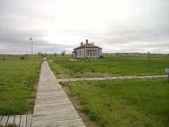 | Fort Buford State Historic Site | site | 1975 | 75001308 |
 | James Memorial Library | building | 1979 | 79001777 |
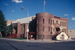 | Old Armory | building | 1985 | 85000787 |
 | Old US Post Office | building | 1979 | 79003729 |
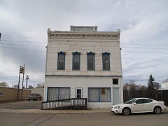 | Ray Opera House | building | 1978 | 78001997 |
| Williston High School | building | 2011 | 11000413 |
Every wildfire the federal occurrence database records inside this county: 112 of them, burning about 3,666 acres. 4 started naturally and 2 were recorded as arson. Each settlement page carries the fires within five miles of it.
| Reported cause | Fires |
|---|---|
| Fireworks | 23 |
| Equipment and vehicle use | 20 |
| Debris and open burning | 19 |
| Missing data/not specified/undetermined | 18 |
| Smoking | 10 |
| Power generation/transmission/distribution | 10 |
| Natural | 4 |
| Recreation and ceremony | 4 |
| Arson/incendiarism | 2 |
| Railroad operations and maintenance | 1 |
| Misuse of fire by a minor | 1 |
The five largest, by the area the report gives. None of them was recorded as arson.
| Date | Cause | Size | Reported by | Name on the report |
|---|---|---|---|---|
| 24 October 2000 | Equipment and vehicle use | 620 acres | Crosby Wetland Management District | TWIN LKS |
| 9 September 2005 | Equipment and vehicle use | 600 acres | North Dakota State Forest Service | not named |
| 15 August 2015 | Equipment and vehicle use | 400 acres | North Dakota State Forest Service | ALAMO MUTUAL AID SKAARE FIRE |
| 9 April 2015 | Missing data/not specified/undetermined | 360 acres | North Dakota State Forest Service | HEDLAND FIRE |
| 4 September 2020 | Misuse of fire by a minor | 330 acres | North Dakota State Forest Service | 200904 |
| 24 March 2020 | Equipment and vehicle use | 300 acres | North Dakota State Forest Service | EPPING FD MA |
| 21 May 1993 | Missing data/not specified/undetermined | 205 acres | Crosby Wetland Management District | LAKE ZAHL |
| 23 June 2005 | Natural | 200 acres | Northeastern Land Office | BUG FARM |
Every settlement page carries the fires within five miles of it - see the settlement index below.
The NOAA Storm Events Database holds 462 reports for this county, causing 1 death, 2 injuries and about $8,301,500 in recorded property damage. Each settlement page carries the reports that name it.
| Kind of event | Reports |
|---|---|
| Hail | 229 |
| Thunderstorm Wind | 177 |
| Tornado | 25 |
| Funnel Cloud | 17 |
| Flood | 6 |
| Flash Flood | 4 |
| Lightning | 3 |
| Dust Devil | 1 |
The most serious of them, by death, then injury, then recorded damage. The accounts are quoted exactly as the forecast office filed them.
| When | Event | Place named | Harm | What the report says |
|---|---|---|---|---|
| June 1990 | Thunderstorm Wind | not stated | 1 killed, 1 hurt | no account filed |
| May 2006 | Dust Devil | Trenton | 1 hurt | A dust devil or whirlwind blew through Trenton. A four year old girl was injured as the trampoline she was playing on was lifted about 25 feet into the air. The trampoline landed back on the ground about 60 feet from its original position. The child was found under the trampoline. The child was transported by ambulance to Mercy Hospital in Williston. Detailed reports were provided by the Williams County Sheriff. |
| June 2021 | Hail | Williston | $1,000,000 | This was the first of multiple rounds of hail to strike the Williston area the evening of June 10. With this round, hail up to the size of tennis balls fell over the Williston area. This caused damage to many roofs and vehicles, including damaging every police car in the city, and every vehicle parked in the Williams County facility lot. In addition, strong winds with this storm blew a roof off a truck and car wash. |
| September 2014 | Thunderstorm Wind | Williston | $1,000,000 | Analysis of damage photos indicated that the peak wind was around 80 mph. The Williston Airport ASOS measured 71 mph at 8:33 PM CDT, but the worst damage was in other parts of Williston. Large trees were snapped and uprooted, fences were destroyed, and vehicles were destroyed by falling trees. It was estimated that the high winds lasted for about 10 minutes. Half dollar sized hail was also reported at this time. |
| June 2021 | Flash Flood | (Isn)Sloulin Fld Wil | $800,000 | Up to five inches of rain fell in the Williston area as multiple rounds of thunderstorms passed through. This led to widespread street flooding, with water affecting many homes. In addition, multiple vehicles were damaged by the flood waters. This includes a combination of parked vehicles and ones where the driver entered the flood waters. |
| August 1999 | Hail | Ray | $600,000 | Hail damage to 30 homes, 150 vehicles and 30 to 100 percent crop damage. |
| July 2022 | Hail | Williston | $500,000 | Large hail fell over the Williston area causing damage to roofs, siding, and vehicles. |
| June 2015 | Flash Flood | Trenton | $500,000 | Over two inches of rain fell in a very short time period and led to flash flooding along parts of North Dakota Highway 1804 southwest of Williston. People were isolated by flood waters and unable to leave their homes at the flood peak. Damage occurred to roads and soil was significantly eroded in several areas. |
| August 1993 | Hail | Williston | $500,000 | Between 3.00 and 7.00 inches of rain fell over a large part of Williams, Divide, Burke, and Mountrail Counties overnight August 21st and 22nd. Water damage from the heavy rains was widespread. A section of Highway 1804 was completely washed out. The downpour swept a motor home off the highway near Lewis and Clark State Park. Fortunately, the occupants escaped injury. |
| July 2007 | Thunderstorm Wind | Williston Arpt | $450,000 | ASOS at the Williston, North Dakota Airport recorded a 65 knot (75 mph) wind gust at 4:18 a.m. CDT Monday, July 23rd. Williams County Emergency Manager indicated that nearly all of the damage was confined to the airport property. The city of Williston had no more damage than some small tree limbs broken. Many buildings on the airport property were damaged, along with several aircraft. Specifically, major damage occurred to three aircraft hangars, minor damage to three airplane storage buildings, and damage to two single engine aircraft and one twin engine aircraft. An electrical line was also damaged, support beams on buildings were buckled, and parts of roofs were blown off. A helicopter was pushed 50 feet and turned 90 degrees. With the damage confined to such a small area (the airport property), and a small area of the airport (less than 1/2 mile) it was determined that this event was a microburst. Based on the damage it was determined that the highest wind likely missed the ASOS and was on the order of 82 knots (94 mph), estimated. |
| July 2022 | Thunderstorm Wind | Wildrose | $325,000 | Sheet metal walls from out-buildings were blown into vehicles, campers, and motorhomes causing damage in the Wildrose area. Some trees were uprooted, with a few large diameter trees snapped and blocking streets. Power was out to the entire town. |
| May 2011 | Flood | Buford | $250,000 | See the event episode narrative for details. |
| May 1977 | Tornado (F1) | not stated | $250,000 | no account filed |
| June 1976 | Tornado (F2) | not stated | $250,000 | no account filed |
| June 2021 | Hail | Williston | $200,000 | This is the second in a series of storms to strike the Williston area. Ping pong size hail accompanied this storm, along with very heavy rainfall. Additional damage was done to roofs and vehicles. |
| June 2021 | Thunderstorm Wind | Hanks | $150,000 | Mountrail-Williams electric recorded 52 poles broken, which includes a one-mile long stretch where every pole was broken southeast of Grenora. In addition, a large tree was blown down in Zahl. |
| July 2014 | Hail | Alamo | $125,000 | There was a lot of crop and property damage reported. |
| July 2020 | Thunderstorm Wind | (Isn)Sloulin Fld Wil | $100,000 | Much of a metal roof was removed from a building. Debris was spread to the southeast. Some travel trailers nearby were damaged, with one being destroyed. |
| June 2016 | Thunderstorm Wind | Williston | $100,000 | Estimated 75 mph thunderstorm wind gusts occurred at the Williams County Fairgrounds. The Williams County Fair was ongoing at the time, and almost all the large tents set up were blown over. No injuries or fatalities occurred. |
| June 2014 | Flood | Grenora | $100,000 | Radar estimated three to five inches of rain in parts of northwest Williams and Divide counties. Damage was reported to culverts and roads. Deep water was standing in farm yards but the National Weather Service received no reports of water in homes. Crops were damaged. |
| July 2014 | Hail | Ray | $75,000 | Wind driven hail resulted in damage to homes and vehicles in the city of Ray. |
| June 2018 | Thunderstorm Wind | Ray | $70,000 | Siding was torn off homes in Ray. |
| July 2014 | Thunderstorm Wind | Ray | $65,000 | The strong winds knocked a wind charger tower over onto a car. Hail accompanied the high winds. |
| June 2024 | Hail | Mc Gregor | $50,000 | Vehicles and roofs were damaged. |
| June 2021 | Thunderstorm Wind | Buford | $50,000 | A large pole barn was heavily damaged with one end of the building and an adjacent part of the roof destroyed. |
| May 2014 | Hail | Buford | $50,000 | Damage was reported to vehicles, roofs, and crops. |
| July 2010 | Hail | Epping | $50,000 | The large hail resulted in borken windows in the town of Epping. |
| August 2011 | Thunderstorm Wind | Williston | $45,000 | Tree branches were broken off at the Williston airport and a new hanger was damaged. |
| May 2010 | Flash Flood | Grenora | $45,000 | Several culverts were washed out along with flooding at an oil drilling site. |
| June 2021 | Thunderstorm Wind | Trenton | $40,000 | Part of a roof was blown off a building, and another small building was blown over. |
| August 2010 | Hail | Williston | $40,000 | Windows were broken on the north side of a home, and car windshields were broken out. |
| July 1999 | Thunderstorm Wind | Williston | $40,000 | no account filed |
| August 2010 | Hail | Williston | $35,000 | Damage was sustained to vehicles and siding on a home. |
| August 2010 | Hail | Williston | $35,000 | no account filed |
| July 2020 | Thunderstorm Wind | Williston | $30,000 | Damage included a quonset door caving in, shingles and soffit being ripped off a building, and tree damage. |
| August 2025 | Thunderstorm Wind | Tioga | $25,000 | A camper-trailer flipped on Highway 2. |
| June 2014 | Flood | Corinth | $25,000 | Flooding occurred over northeast Williams County. Damage occurred to roads and culverts with many wash outs along township roads. There was crop damage as well. Rain amounts ranged from 2.50 inches in Bottineau County to as much as 7.00 inches in Renville County. |
| July 2010 | Lightning | Williston | $25,000 | Lightning struck a mobile home in Williston, resulting in a fire to the residence. Nobody was injured in the fire. |
| June 1982 | Tornado (F2) | not stated | $25,000 | no account filed |
| June 1966 | Tornado (F0) | not stated | $25,000 | no account filed |
| June 2021 | Thunderstorm Wind | Trenton | $20,000 | A roof was damaged. |
| May 2010 | Flash Flood | Alamo | $20,000 | Public reports of flash flooding were received via broadcast media over rural north central Williams County. Rainfall rates were reported to be around two inches in less than 45 minutes. Some county roads were damaged by the flowing water. |
| July 2006 | Hail | Ray | $20,000 | Spotters indicated that the most intense part of the hail swath from this storm began around 20 miles west of Ray, just to the south of Blacktail Dam, and was around 1 mile wide as it extended to approximately 2 miles north of Ray. The hail was accompanied by damaging thunderstorm winds in excess of 60 mph, which broke out windows and resulted in 100 percent crop loss in the hardest hit areas. Quarter size hail was also reported in the town of Ray, and was also accompanied by strong thunderstorm winds. This was part of the same storm which resulted in damage to the west and north of Ray. |
| August 1997 | Lightning | Tioga | $20,000 | lightning struck an oil holding tank. The resulting fire spread to another holding tank. Fire crews were able to get the fire put out before the tanks were a complete loss. |
| July 2017 | Thunderstorm Wind | Williston | $15,000 | Elm trees in a park were knocked over by the thunderstorm wind gusts. Minor damage occurred to a tin roof on a structure where some panels lifted off. |
| July 2015 | Thunderstorm Wind | Ray | $15,000 | Wind speed estimate is based off of widespread tree damage around Ray. |
| July 2012 | Thunderstorm Wind | Grenora | $15,000 | A cattle wind break eight feet high was flattened and a wooden calf shelter was destroyed. |
| August 2010 | Hail | Trenton | $15,000 | The large hail resulted in broken windows on a home. |
| August 2010 | Hail | Williston | $12,000 | A camper and truck were dented. |
| July 2018 | Hail | Bonetraill | $10,000 | A window was broken on the north side of a house. That allowed wind and water into the home. |
| July 2015 | Thunderstorm Wind | (Isn)Sloulin Fld Wil | $10,000 | Shingles were blown off a roof, and barn doors were blown out. |
| June 2014 | Hail | Ray | $10,000 | There was minor damage to vehicles along U.S. Highway 2. |
| July 2012 | Thunderstorm Wind | Bonetraill | $10,000 | The strong winds blew down a tree onto a power line. |
| July 2009 | Thunderstorm Wind | Williston | $10,000 | A severe thunderstorm wind gust resulted in the destruction of a storage pole barn. |
| August 2009 | Hail | (Isn)Sloulin Fld Wil | $10,000 | Large hail resulted in damage to crops and vehicles. |
| July 2012 | Thunderstorm Wind | Grenora | $8,000 | A twenty foot tall elm tree was knocked down. |
| July 2009 | Thunderstorm Wind | Spring Brook | $5,000 | Severe thunderstorm wind gusts resulted in leaning power poles and six to eight inch in diameter tree branches down. |
| August 1997 | Thunderstorm Wind | Williston | $5,000 | thunderstorm winds caused a tree to fall across a pickup |
| June 2008 | Hail | Buford | $4,000 | This hail fell at the Fort Union National Historic Site. Most of the hail was one inch in diameter. About a dozen windows were broken. |
| June 2007 | Thunderstorm Wind | Williston | $4,000 | Several small tree branches broken. Newspaper article showed one larger branch snapped off at the tree trunk and landed on a camper trailer parked under the tree. The roof of the camper was dented. Accompanied by penny size hail. |
The Survey's mineral resources record lists 9 workings inside this county. 4 still produce and 5 are closed or unrecorded. Each settlement page carries the workings within five miles of it.
| Commodity | Workings |
|---|---|
| Sand and Gravel, Construction | 9 |
The least common of them first, because a county's hundredth gravel pit says nothing its first ten did not.
| Where | Site | Commodity | Status | Recorded |
|---|---|---|---|---|
| Cactus 64sh Plant | Sand and Gravel, Construction | Producer | ||
| Cherry Pit | Sand and Gravel, Construction | Producer | ||
| Hoffelt Gravel Pit | Sand and Gravel, Construction | Producer | ||
| K Kulland Pit and Plant | Sand and Gravel, Construction | Past Producer | ||
| Kettle Lake Pit and Plant | Sand and Gravel, Construction | Producer | ||
| Knudsen Pit 2 | Sand and Gravel, Construction | Unknown | ||
| Streifel Pit and Plant | Sand and Gravel, Construction | Past Producer | ||
| Sundhagen Pit and Plant | Sand and Gravel, Construction | Past Producer | ||
| Weyrauch Pit | Sand and Gravel, Construction | Unknown |
Named settlements recorded in the Geographic Names Information System, each with the topographic sheets covering it. Villages, hamlets and abandoned places alike. Each is shown with the nearest named watercourse or landform and the survey quadrangle it falls on.
Stony Creek township · 58801 · On Stockyard Creek · Williston East quadrangle
6 sheets, 1953 to 1983
Twelve Mile township · 58843 · By Sliding Bluff (historical) · Lake Jessie quadrangle
7 sheets, 1911 to 1983
Nesson Valley township · 58849 · On Tobacco Garden Creek · Cussicks Spring quadrangle
7 sheets, 1911 to 1983