
BlockBefore
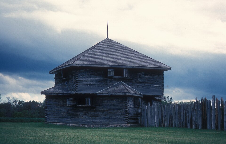
Photograph of Fort Abercrombie
Photograph by JERRYE & ROY KLOTZ MD, CC BY-SA 3.0. Via Wikimedia Commons.

Fort Abercrombie

Listed on the National Register of Historic Places in 2009.

From the record

“Fort Abercrombie, in North Dakota, was a United States Army fort established by authority of an Act of Congress, March 3, 1857. The act allocated twenty-five square miles of land on the Red River of the North in Dakota Territory to be used for a military outpost, but the exact location was left to the discretion of Lieutenant Colonel John J.”

Wikipedia article Fort Abercrombie, CC BY-SA 4.0.

One of 12 National Register listings published here for Richland County · listed in 2009 · category: Site.

Sources: the Wikipedia article · the case file at the National Archives · the National Register database, National Park Service

The listing

  • Address. Richland Co. Rte. 4, Abercrombie, 58001
  • When was it listed? January 2009
  • Category. site
  • City. Abercrombie city
  • National Register reference number. 08001367 - the number the National Park Service assigned this property when it was listed, and the key its nomination file is catalogued under at the National Archives.

Storms near this property

15 since 1998

Regional context, not property-specific evidence. The National Weather Service names Abercrombie, the town this property stands in, in 15 storm reports between 1998 and 2024: 8 hail, 2 thunderstorm wind, 2 flash flood, 2 flood. No death or injury is recorded in these reports. Each account below is quoted exactly as the forecast office filed it, from the NOAA Storm Events Database, and each date opens the federal record of that event.

WhenEvent Place namedHarm What the report says
August 2008Flash FloodAbercrombie$30,000Several fields and farm access roads were flooded due to runoff from heavy rains in northeast Richland County. The water slowly subsided through the morning of the 12th as runoff moved into the larger river system.
May 2024FloodAbercrombie$500Wahpeton Gage, on the Red River. Crested at 11.01 ft on May 25th at 4:45 pm.
May 1998Thunderstorm WindAbercrombie$200The strong wind blew several trees down.
August 2016HailAbercrombie-A lot of small hail fell, but there were a few larger stones as well.
August 2012Thunderstorm WindAbercrombie-Winds estimated at 70 to 80 mph blew down and uprooted trees.
June 2007FloodAbercrombie-In Dwight, 4 homes and a church had sewer backup or basement flooding. The heavy rain filled ditches and streets and caused a creek on the perimeter of town to rise four feet. In Wahpeton, roughly 20 to 40 homes had sewer backup or basement flooding. Around the town of Fairmount, thousands of acres of cropland was drowned out and it was now too late to re-plant. The Richland County highway engineer estimated 40 to 45 road and bridge closures. Two river gauges in Richland County reported immediate impacts from the runoff. On the Wild Rice River at Abercrombie, which was showing a level of about 4.75 feet on the morning of the 2nd, the river stage shot up to around 21 feet by the early morning hours of the 5th (a jump of over 16 feet in nearly 3 days). The stage of around 21 feet would qualify as a top ten historical crest. On the Red River at Wahpeton/Breckenridge, which was showing a level of about 9.3 feet on the morning of the 1st, the river stage shot up to around 15.6 feet by late in the afternoon of the 3rd (a jump of over 6 feet in about 2 days). Again, the 15.6 river peak would qualify as a top ten historical crest.
August 2005HailAbercrombie-Pea to nickel sized hail fell near the Red River.
August 2005Flash FloodAbercrombie-About 5 inches of rain fell over a large portion of Eagle Township, mainly during a three hour period from 10 PM to 1 AM CDT. Excessive runoff from the heaviest rainfall caused ditches and small streams to overflow and inundate local fields and farmyards. Water briefly flowed across county highway 81 near Enloe.
June 2009Heavy RainAbercrombie-no account filed
May 2005HailAbercrombie-no account filed
September 2005HailAbercrombie-no account filed
August 2004HailAbercrombie-no account filed
June 2001HailAbercrombie-no account filed
July 1998HailAbercrombie-no account filed

Every storm recorded in Richland County

Map coverage status

No historic map-sheet match is published for this property yet. That does not mean no map exists. This record needs a coordinate-quality review before it can be joined to a sheet boundary. Browse the county's mapped places while that work is pending.

Listed places nearby

1 within 8 miles

Other National Register properties close enough to walk or drive between, ordered by distance from this one. Both positions come from the same geocoding pass that matched these properties to their map sheets.

Photograph PropertyDistance Listed
South Wild Rice Church4.3 miles1982

Sources for this property

National Archives recordThe nomination case file for reference 08001367 in Record Group 79.
Wikipedia articleCommunity-written account of this property, licensed CC BY-SA.
Richland CountyAll 12 listed properties in this county.

Provenance

  • Listing record. National Park Service National Register of Historic Places, listed-properties dataset, current to 2026-05-22.
  • Map join. Address geocoded through the United States Census geocoder, then tested against the published boundary of every sheet in the USGS Historical Topographic Map Collection.
  • How this page is made. Listing fields come from federal records; map-sheet coverage is a labelled coordinate-to-boundary calculation, not a source-field claim.
  • Storms. NOAA National Centers for Environmental Information, Storm Events Database https://www.ncei.noaa.gov/stormevents/ A work of the United States government, no copyright under 17 U.S.C. 105. Narratives are quoted verbatim from the National Weather Service report and are not edited or summarised.