
BlockBefore

Burlington Northern Depot

Listed on the National Register of Historic Places in 1977.

From the record

“Amenia station is a historic railroad station in Amenia, North Dakota, United States. It was built in 1880, and was designed and/or built by the Northern Pacific Railroad.”

Wikipedia article Amenia station (North Dakota), CC BY-SA 4.0.

One of 38 National Register listings published here for Cass County · listed in 1977 · category: Building.

Sources: the Wikipedia article · the National Register database, National Park Service
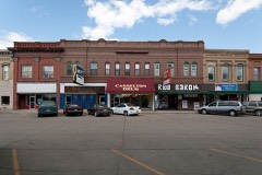
The listing

  • Listing status. The Park Service records this property as Removed.
  • What is counted as historic. The nomination lists 1 building as contributing to the listing.
  • Address. Woodard Ave., Amenia, 58004
  • When was it listed? August 1977
  • Category. building
  • City. Amenia city
  • National Register reference number. 77001024 - assigned by the National Park Service when the property was listed.

Storms near this property

7 since 1999

Regional context, not property-specific evidence. The National Weather Service names Amenia, the town this property stands in, in 7 storm reports between 1999 and 2025: 4 hail, 1 flash flood, 1 tornado, 1 thunderstorm wind. No death or injury is recorded in these reports. Each account below is quoted exactly as the forecast office filed it, from the NOAA Storm Events Database, and each date opens the federal record of that event.

WhenEvent Place namedHarm What the report says
July 2011Tornado (EF2)Amenia$150,000This tornado tracked southeastward for nearly three miles to around three miles northwest of Mapleton. The tornado took down three sets of wooden high voltage double power poles. It continued into a farmyard and completely removed the roof from one farmhouse and blew apart the attached garage. A semi tractor and trailer in the yard were rolled. Numerous trees were snapped or uprooted and smaller sheds were destroyed. Peak winds were estimated at 130 mph.
August 2025Thunderstorm WindAmenia-Measured wind on 10 meter wind sensor at the Casselton NDAWN.
July 2004Flash FloodAmenia-4.5 inches of rain flooded several rural roads.
July 2004HailAmenia-no account filed
July 2002HailAmenia-no account filed
September 2002HailAmenia-no account filed
July 1999HailAmenia-no account filed

Every storm recorded in Cass County

Map coverage status

No historic map-sheet match is published for this property yet. That does not mean no map exists. This record needs a coordinate-quality review before it can be joined to a sheet boundary. Browse the county's mapped places while that work is pending.

Listed places nearby

2 within 8 miles

Other National Register properties close enough to walk or drive between, ordered by distance from this one. Both positions come from the same geocoding pass that matched these properties to their map sheets.

Photograph PropertyDistance Listed
St. Stephen's Episcopal Church7.1 miles1992
Casselton Commercial Historic District7.2 miles1982

Sources for this property

National Archives recordThe nomination case file for reference 77001024 in Record Group 79.
Wikipedia articleCommunity-written account of this property, licensed CC BY-SA.
Cass CountyAll 38 listed properties in this county.

Provenance

  • Listing record. National Park Service National Register of Historic Places, listed-properties dataset, current to 2026-05-22.
  • Map join. Address geocoded through the United States Census geocoder, then tested against the published boundary of every sheet in the USGS Historical Topographic Map Collection.
  • How this page is made. Listing fields come from federal records; map-sheet coverage is a labelled coordinate-to-boundary calculation, not a source-field claim.
  • Storms. NOAA National Centers for Environmental Information, Storm Events Database https://www.ncei.noaa.gov/stormevents/ A work of the United States government, no copyright under 17 U.S.C. 105. Narratives are quoted verbatim from the National Weather Service report and are not edited or summarised.