
BlockBefore
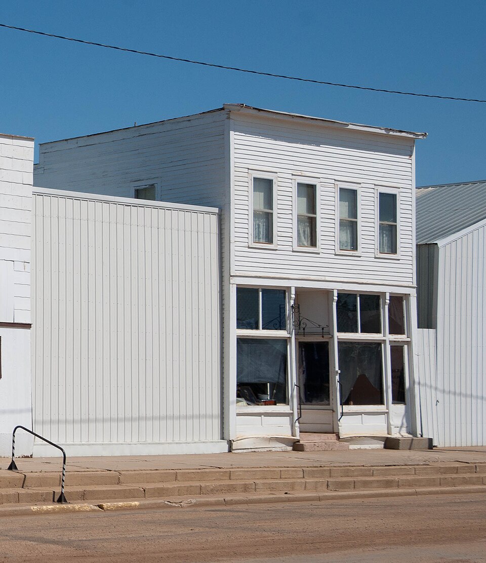
Photograph of Dr. S.W. Hill Drug Store
Photograph by Andrew Filer ( afiler ), CC BY-SA 2.0. Via Wikimedia Commons.

Dr. S. W. Hill Drug Store

Listed on the National Register of Historic Places in 1980.

From the record

“Hill Drug Store in Regent, North Dakota, United States, was built in 1910. It is one of eight buildings that make up the Hettinger County Historical Society Museum.”

Wikipedia article Dr. S.W. Hill Drug Store, CC BY-SA 4.0.

One of 6 National Register listings published here for Hettinger County · listed in 1980 · category: Building.

Sources: the Wikipedia article · the case file at the National Archives · the National Register database, National Park Service

The listing

  • What is counted as historic. The nomination lists 1 building as contributing to the listing.
  • Listed as. Hill, Dr. S. W., Drug Store - the National Register files a house under its owner's surname.
  • Address. Off ND 21, Regent, 58650
  • When was it listed? November 1980
  • Category. building
  • City. Regent city
  • National Register reference number. 80002916 - the number the National Park Service assigned this property when it was listed, and the key its nomination file is catalogued under at the National Archives.

Fires near this property

3 since 2017

Regional context, not property-specific evidence. The federal wildfire occurrence database lists 3 fires within 5 miles of Dr. S. W. Hill Drug Store between 2017 and 2019, burning about 303 acres in total. None started naturally. None was recorded as arson. Distance is straight-line from the map coordinates, so a fire counted here may appear on a neighbouring settlement's page as well.

Reported cause Fires
Equipment and vehicle use3

The most recent of them, most recent first, with the day each was reported and the service that recorded it.

DateCause SizeReported by Name on the report
21 August 2017Equipment and vehicle use1.0 acresNorth Dakota State Forest ServiceROBERT CARLSON
20 August 2019Equipment and vehicle use2.0 acresNorth Dakota State Forest ServiceJERALD RAFFERTY'S CRP
11 July 2017Equipment and vehicle use300 acresNorth Dakota State Forest ServiceBRIAN KOUBA

Every fire recorded in Hettinger County

Storms near this property

60 of 75 shown

Regional context, not property-specific evidence. The National Weather Service names Regent, the town this property stands in, in 75 storm reports between 1994 and 2025: 48 hail, 19 thunderstorm wind, 3 flash flood, 3 funnel cloud. No death or injury is recorded in these reports. Each account below is quoted exactly as the forecast office filed it, from the NOAA Storm Events Database, and each date opens the federal record of that event.

WhenEvent Place namedHarm What the report says
June 2016HailRegent$100,000Initial hail report was for ping pong ball sized hail, but hail increased to tennis ball sized hail in subsequent report.
July 2008Thunderstorm WindRegent$100,000Power lines were reported down and three grain bins were destroyed.
July 2010HailRegent$75,000City officials in Regent reported minor hail damage.
August 2021HailRegent$35,000Vehicles were severely damaged, which included broken windshields.
June 2016Flash FloodRegent$30,000Water was running three feet deep through some streets in the city of Regent. Ditches were also overflowing along the Enchanted Highway to the north of Regent with water running over the road. Reports were also received by the National Weather Service of three inches of rain falling in a short period of time.
July 1997LightningRegent$25,000lightning struck a barn causing it to catch fire. A nearby farm caught fire as well. Both barns were destroyed.
June 1994HailRegent$5,000no account filed
July 2021Thunderstorm WindRegent-Thunderstorm wind gusts were estimated by the public.
July 2016Thunderstorm WindRegent-A trained spotter estimated thunderstorm wind gusts of 70 mph.
June 2014Funnel CloudRegent-This funnel cloud did not touch the surface. This report was relayed through North Dakota State Radio with pictures of this funnel cloud received via social media.
July 2012Thunderstorm WindRegent-The strong winds combined with large hail resulted in damage to area crops.
July 2012HailRegent-The hail combined with strong winds resulted in damage to area crops.
July 2012Thunderstorm WindRegent-Large hail accompanied the strong winds.
August 2011Thunderstorm WindRegent-Pea size hail accompanied the strong winds.
August 2010Thunderstorm WindRegent-Estimated winds of 80 mph were reported.
July 2010Thunderstorm WindRegent-Large hail accompanied the strong thunderstorm winds.
June 2009HailRegent-Hail up to the size of half dollar coins lasted ten minutes.
June 2005HailRegent-1 inch of rain in 15 minutes.
July 2004HailRegent-Total crop damage observed along Highway 22 by a NWS cooperative observer.
August 2002Thunderstorm WindRegent-An old storage shed destroyed . Hailstones nearly dime size piled a few feet deep in ditches. Neary 2 inches of rain fell with the storm. Many crops leveled by wind driven hail and very heavy rain.
August 2002Thunderstorm WindRegent-An abandoned church was badly damaged by the wind.
July 2001Tornado (F0)Regent-Briefly touched down in open country.
July 2001Flash FloodRegent-Unknown amount of rain caused flooding of back roads. Unconfirmed reports of some back roads washing out.
July 2001Flash FloodRegent-Up to 4 inches of rain fell during a 12 hour period causing flooding of ditches and some back roads.
July 2000Thunderstorm WindRegent-Tree's toppled by the winds.
June 2025Thunderstorm WindRegent-no account filed
July 2025Thunderstorm WindRegent-no account filed
July 2025HailRegent-no account filed
August 2025Thunderstorm WindRegent-no account filed
September 2024Thunderstorm WindRegent-no account filed
July 2022Thunderstorm WindRegent-no account filed
July 2021HailRegent-no account filed
August 2021HailRegent-no account filed
August 2020HailRegent-no account filed
June 2020HailRegent-no account filed
July 2019HailRegent-no account filed
July 2018HailRegent-no account filed
June 2018HailRegent-no account filed
June 2018Funnel CloudRegent-no account filed
June 2018HailRegent-no account filed
June 2016HailRegent-no account filed
June 2015Funnel CloudRegent-no account filed
June 2014HailRegent-no account filed
July 2012HailRegent-no account filed
July 2011HailRegent-no account filed
July 2010HailRegent-no account filed
June 2009HailRegent-no account filed
July 2008Thunderstorm WindRegent-no account filed
May 2007Thunderstorm WindRegent-no account filed
June 2006HailRegent-no account filed

Every storm recorded in Hettinger County

Map coverage status

No historic map-sheet match is published for this property yet. That does not mean no map exists. This record needs a coordinate-quality review before it can be joined to a sheet boundary. Browse the county's mapped places while that work is pending.

Sources for this property

National Archives recordThe nomination case file for reference 80002916 in Record Group 79.
Wikipedia articleCommunity-written account of this property, licensed CC BY-SA.
Hettinger CountyAll 6 listed properties in this county.

Provenance

  • Listing record. National Park Service National Register of Historic Places, listed-properties dataset, current to 2026-05-22.
  • Map join. Address geocoded through the United States Census geocoder, then tested against the published boundary of every sheet in the USGS Historical Topographic Map Collection.
  • How this page is made. Listing fields come from federal records; map-sheet coverage is a labelled coordinate-to-boundary calculation, not a source-field claim.
  • Wildfire. Short, Karen C. 2022. Spatial wildfire occurrence data for the United States, 1992-2020 [FPA_FOD_20221014]. 6th Edition. Fort Collins, CO: Forest Service Research Data Archive. https://doi.org/10.2737/RDS-2013-0009.6 Collected with United States Government funding and usable without additional permissions or fees.
  • Storms. NOAA National Centers for Environmental Information, Storm Events Database https://www.ncei.noaa.gov/stormevents/ A work of the United States government, no copyright under 17 U.S.C. 105. Narratives are quoted verbatim from the National Weather Service report and are not edited or summarised.