 Block
From the record
6 National Register listings published here.
Sources: the National Register database, National Park Service
11 topographic sheets cover 7 settlements here, and 6 properties are on the National Register of Historic Places.
6 National Register listings published here.
Sources: the National Register database, National Park Service
Every property in this county listed on the National Register of Historic Places, with the year it was listed and the federal nomination document.
| Photograph | Property | Type | Listed | Reference |
|---|---|---|---|---|
| Andrew Erickson Barn | building | 2023 | 100009697 | |
 | Hettinger County Courthouse | building | 1985 | 85002984 |
 | Dr. S. W. Hill Drug Store | building | 1980 | 80002916 |
 | Neuburg Congregational Church | building | 2007 | 07000822 |
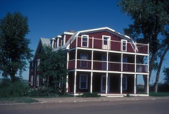 | Riverside | building | 1983 | 83001937 |
 | Stern, John and Fredricka (Roth), Homestead | building | 2008 | 08000902 |
Every wildfire the federal occurrence database records inside this county: 58 of them, burning about 1,032 acres. 5 started naturally and none was recorded as arson. Each settlement page carries the fires within five miles of it.
| Reported cause | Fires |
|---|---|
| Equipment and vehicle use | 30 |
| Debris and open burning | 13 |
| Natural | 5 |
| Missing data/not specified/undetermined | 5 |
| Other causes | 3 |
| Smoking | 2 |
The five largest, by the area the report gives. None of them was recorded as arson.
| Date | Cause | Size | Reported by | Name on the report |
|---|---|---|---|---|
| 11 July 2017 | Equipment and vehicle use | 300 acres | North Dakota State Forest Service | BRIAN KOUBA |
| 7 August 2018 | Equipment and vehicle use | 100 acres | North Dakota State Forest Service | BIEBER FIRE |
| 22 August 2018 | Equipment and vehicle use | 100 acres | North Dakota State Forest Service | GREG URLACHER |
| 2 September 2018 | Debris and open burning | 50 acres | North Dakota State Forest Service | AUCH FIRE |
| 31 March 2015 | Equipment and vehicle use | 50 acres | North Dakota State Forest Service | HARTMAN BURN |
| 28 August 2016 | Equipment and vehicle use | 40 acres | North Dakota State Forest Service | REGENT MUTUAL AID |
| 17 August 2016 | Equipment and vehicle use | 40 acres | North Dakota State Forest Service | HAYBINE FIRE |
| 19 March 2012 | Debris and open burning | 35 acres | North Dakota State Forest Service | NEW ENGLAND |
Every settlement page carries the fires within five miles of it - see the settlement index below.
The NOAA Storm Events Database holds 303 reports for this county, causing 3 deaths, 4 injuries and about $7,651,000 in recorded property damage. Each settlement page carries the reports that name it.
| Kind of event | Reports |
|---|---|
| Hail | 162 |
| Thunderstorm Wind | 103 |
| Tornado | 20 |
| Funnel Cloud | 8 |
| Flash Flood | 4 |
| Flood | 4 |
| Heavy Rain | 1 |
| Lightning | 1 |
The most serious of them, by death, then injury, then recorded damage. The accounts are quoted exactly as the forecast office filed them.
| When | Event | Place named | Harm | What the report says |
|---|---|---|---|---|
| May 2022 | Flood | Mott | 2 killed, $30,000 | A married couple, both 74 years old, died after driving into the water at a low water crossing. This crossing is locally known to have water running through it during snowmelt and rain events. At the time of the attempted crossing, the water was approximately three to four feet deep over the low water crossing. |
| June 1975 | Tornado (F4) | not stated | 1 killed, 4 hurt, $2,500,000 | no account filed |
| July 2019 | Tornado (EF1) | Mott | $1,600,000 | The tornado touched down roughly two miles north-northwest of Mott, and tracked to the south-southeast before lifting about one mile east-southeast of town, having passed through the northeast corner of the city. Extensive tree damage occurred in Mott, mostly from high winds associated with the Rear-Flank Downdraft of the tornado. Farm bins were torn from their foundations, a shed was destroyed, and a very large building on the fairgrounds was collapsed. Near the intersection of ND Highway 8 and 21 the roof was torn from a storage facility. A house just east of there, along ND Highway 21, had the attached garage shifted off its foundation and collapsed. Based on the damage done this tornado was rated EF1 with estimated wind speeds around 105 mph. |
| July 2010 | Hail | Mott | $750,000 | County officials reported up to baseball size hail in Mott. All vehicles left outside received major damage. The north side of homes sustained siding damage and broken windows. Roofs were also damaged from the large hail. |
| July 2010 | Hail | Burt | $400,000 | County officials reported up to softball size hail in Burt. All vehicles left outside received major damage. The north side of homes sustained siding damage and broken windows. Roofs were also damaged from the large hail. |
| June 2016 | Thunderstorm Wind | Burt | $250,000 | Damaging winds of 80 mph were accompanied by 2.25 inch diameter hail to cause extensive damage to outbuildings and windows on a farm to the north of Burt. Grain bins were torn off their foundations and thrown into a nearby field. Crops were flattened. |
| August 1975 | Tornado (F1) | not stated | $250,000 | no account filed |
| June 2016 | Tornado (EF1) | Mott Muni Arpt | $200,000 | A tornado moved from southwest of Mott towards the east-northeast for just over three miles. Initial damage was to large cottonwood trees at a farmstead, along with light damage to the home. About half-way through the tornado path, another home was severely damaged. The entire attached three stall garage was destroyed and half the roof was torn from the home. Windows were broken and vehicles were damaged. Debris was strewn through nearby fields for one mile. No injuries or fatalities occurred, as the occupants of both homes took shelter. |
| April 2009 | Flood | New England | $193,000 | Heavy overland flooding along with flooding on the Cannonball River damaged a total of eleven homes, some located in the community of Mott. River and overland flooding also damaged several county and local roads. |
| June 2025 | Thunderstorm Wind | Mott | $150,000 | A large farm building was severely damaged. Part of roof was completely ripped off and blown away. Metal roofing was peeled off on remaining portion of the building. All walls were still standing, although doors were missing. |
| August 2010 | Thunderstorm Wind | Mott | $150,000 | Damage was reported to trees and power lines. Damage was also reported to a grain bin and an elevator roof in the city of Mott. |
| June 2016 | Hail | Mott | $150,000 | no account filed |
| June 2016 | Hail | Regent | $100,000 | Initial hail report was for ping pong ball sized hail, but hail increased to tennis ball sized hail in subsequent report. |
| July 2010 | Hail | Mott | $100,000 | Another round of large hail impacted the city of Mott. |
| July 2008 | Thunderstorm Wind | Regent | $100,000 | Power lines were reported down and three grain bins were destroyed. |
| July 2010 | Hail | Regent | $75,000 | City officials in Regent reported minor hail damage. |
| August 2017 | Hail | Burt | $60,000 | There was damage to vehicles and roofs. |
| June 2009 | Tornado (EF0) | New England | $50,000 | This tornado touched down in Stark County and crossed into Hettinger County. See the tornado entry for Stark County 1703 MST to 1707 MST.||The same supercell thunderstorm that produced this EF0 tornado produced an EF1 tornado in Stark County earlier in the day. See the tornado entry 1628 MST to 1645 MST for Stark County.||The tornado touched down in Stark County about seven miles north-northwest of the Hettinger County city of New England. It moved southeast and crossed into Hettinger County and lifted about eight miles west-northwest of Regent, after doing damage to several farms. Several medium to large trees were uprooted and there was window and roof damage to buildings. The damage corresponded to high end EF0 on the Enhanced Fujita Tornado Scale. From that it was determined that wind speeds were around 85 mph. There were no deaths or injuries. |
| June 1994 | Hail | NE Regent | $50,000 | no account filed |
| August 2021 | Hail | Regent | $35,000 | Vehicles were severely damaged, which included broken windshields. |
| September 2024 | Thunderstorm Wind | Burt | $30,000 | A significant portion of a pole barn roof was lifted and folded back. A calf shelter was destroyed, wind bread panels were scattered, and a one-thousand gallon water tank blew over and rolled. |
| June 2016 | Flash Flood | Regent | $30,000 | Water was running three feet deep through some streets in the city of Regent. Ditches were also overflowing along the Enchanted Highway to the north of Regent with water running over the road. Reports were also received by the National Weather Service of three inches of rain falling in a short period of time. |
| July 2011 | Thunderstorm Wind | New England | $30,000 | The strong winds uprooted some trees in New England. |
| July 2014 | Hail | Mott | $30,000 | no account filed |
| July 2013 | Thunderstorm Wind | Mott | $25,000 | The severe thunderstorm winds blew down several large tree limbs in the city of Mott, along with snapping a thirty foot tall tree in half. |
| March 2009 | Flood | New England | $25,000 | Overland flooding damaged some county and township roads. No homes were flooded in March. Worse flooding continued into April. |
| July 1997 | Lightning | Regent | $25,000 | lightning struck a barn causing it to catch fire. A nearby farm caught fire as well. Both barns were destroyed. |
| June 2024 | Thunderstorm Wind | New England | $20,000 | A large tree split and part of it fell onto a house. |
| April 2023 | Flood | New England Arpt | $20,000 | Flooding from snow melt runoff caused significant damages to county infrastructure. |
| June 2022 | Thunderstorm Wind | Bentley | $20,000 | An anchored hopper grain bin was blown over. |
| May 2010 | Thunderstorm Wind | Mott | $20,000 | Severe thunderstorm wind gusts resulted in shingle damage to a home and three to five inch diameter trees broken. |
| July 1997 | Thunderstorm Wind | Mott | $20,000 | tree blown down on top of house |
| June 2016 | Hail | New England | $20,000 | no account filed |
| May 2018 | Thunderstorm Wind | Mott | $15,000 | A wind break was torn down and a roof was damaged. |
| July 2016 | Thunderstorm Wind | Mott | $15,000 | Trees were down in Mott. |
| June 2013 | Flash Flood | New England | $15,000 | Law enforcement reported several roads experiencing flooding of deep water in Hettinger County. |
| June 2009 | Hail | New England | $15,000 | The large hail broke windows on a home. |
| June 2008 | Hail | Mott | $15,000 | Hail up to golfball size lasted for five minutes. Some house windows were knocked out in the city of Mott. |
| June 2007 | Hail | Mott | $15,000 | Windows were reported broken and there was some roof damage. |
| July 2010 | Hail | Burt | $10,000 | Strong winds accompanied the large hail. The large hail resulted in damage to siding on a garage. |
| August 1996 | Thunderstorm Wind | New England | $10,000 | no account filed |
| July 2018 | Hail | New England | $5,000 | Multiple crops were destroyed and many trees had leaves stripped. |
| June 2013 | Thunderstorm Wind | Mott Muni Arpt | $5,000 | Tree tops were snapped. |
| June 2007 | Hail | Mott | $5,000 | The hail caused a few broken windows. |
| June 1994 | Hail | Regent | $5,000 | no account filed |
| June 1994 | Thunderstorm Wind | New England | $5,000 | no account filed |
| June 1978 | Tornado (F1) | not stated | $2,500 | no account filed |
| July 1976 | Tornado (F1) | not stated | $2,500 | no account filed |
| August 1964 | Tornado (F2) | not stated | $2,500 | no account filed |
| June 1980 | Tornado (F0) | not stated | $250 | no account filed |
| August 1951 | Tornado (F1) | not stated | $250 | no account filed |
| July 2021 | Thunderstorm Wind | Regent | - | Thunderstorm wind gusts were estimated by the public. |
| July 2021 | Thunderstorm Wind | Mott | - | Thunderstorm wind gusts were estimated by law enforecment. |
| July 2020 | Thunderstorm Wind | Burt | - | Thunderstorm wind gusts were estimated by a trained spotter. |
| August 2020 | Thunderstorm Wind | New England | - | Thunderstorm wind gusts were estimated by the public. |
| August 2019 | Hail | Burt | - | Extensive crop and garden damage occurred. |
| July 2019 | Thunderstorm Wind | Mott | - | The wind gust was measured as a tornado passed to the east of the NDAWN (North Dakota Agricultural Weather Network) sensor located on the north side of Mott, just off the west side of ND Highway 8. These winds may have been in conjunction with a rear-flank downdraft. |
| July 2017 | Hail | Burt | - | Barley crops were damaged by the hail. |
| July 2016 | Thunderstorm Wind | Regent | - | A trained spotter estimated thunderstorm wind gusts of 70 mph. |
| July 2016 | Thunderstorm Wind | Mott | - | The public estimated thunderstorm wind gusts of 60 mph. |
Named settlements recorded in the Geographic Names Information System, each with the topographic sheets covering it. Villages, hamlets and abandoned places alike. Each is shown with the nearest named watercourse or landform and the survey quadrangle it falls on.