 Block
From the record
6 National Register listings published here.
Sources: the National Register database, National Park Service
34 topographic sheets cover 11 settlements here, and 6 properties are on the National Register of Historic Places.
6 National Register listings published here.
Sources: the National Register database, National Park Service
Every property in this county listed on the National Register of Historic Places, with the year it was listed and the federal nomination document.
| Photograph | Property | Type | Listed | Reference |
|---|---|---|---|---|
| Albion Carnegie Library | building | 2019 | 100003569 | |
 | Cedar Rapids City Hall and Library | building | 1994 | 94000654 |
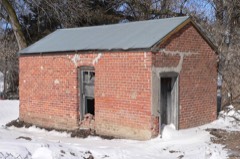 | Petersburg Jail | building | 2005 | 05000154 |
 | St. Anthony's Church and School | building | 2000 | 00000172 |
 | St. Bonaventure Church Complex | building | 1982 | 82000598 |
 | US Post Office-Albion | building | 1992 | 92000475 |
Every wildfire the federal occurrence database records inside this county: 107 of them, burning about 3,188 acres. 3 started naturally and none was recorded as arson. Each settlement page carries the fires within five miles of it.
| Reported cause | Fires |
|---|---|
| Debris and open burning | 42 |
| Missing data/not specified/undetermined | 25 |
| Equipment and vehicle use | 24 |
| Power generation/transmission/distribution | 7 |
| Natural | 3 |
| Railroad operations and maintenance | 2 |
| Smoking | 2 |
| Fireworks | 1 |
| Recreation and ceremony | 1 |
The five largest, by the area the report gives. None of them was recorded as arson.
| Date | Cause | Size | Reported by | Name on the report |
|---|---|---|---|---|
| 13 March 2015 | Missing data/not specified/undetermined | 1,700 acres | Nebraska Forest Service | not named |
| 13 March 2015 | Missing data/not specified/undetermined | 300 acres | Nebraska Forest Service | not named |
| 22 April 2019 | Natural | 240 acres | Nebraska Forest Service | not named |
| 14 February 2019 | Debris and open burning | 200 acres | Nebraska Forest Service | not named |
| 17 October 2012 | Equipment and vehicle use | 110 acres | Nebraska Forest Service | not named |
| 6 March 2011 | Debris and open burning | 70 acres | Nebraska Forest Service | not named |
| 9 November 2018 | Equipment and vehicle use | 65 acres | Nebraska Forest Service | not named |
| 16 March 2015 | Debris and open burning | 40 acres | Nebraska Forest Service | not named |
Every settlement page carries the fires within five miles of it - see the settlement index below.
The NOAA Storm Events Database holds 356 reports for this county, causing 4 deaths, 55 injuries and about $27,509,750 in recorded property damage. Each settlement page carries the reports that name it.
| Kind of event | Reports |
|---|---|
| Hail | 187 |
| Thunderstorm Wind | 106 |
| Tornado | 29 |
| Flash Flood | 21 |
| Flood | 9 |
| Lightning | 2 |
| Funnel Cloud | 2 |
The most serious of them, by death, then injury, then recorded damage. The accounts are quoted exactly as the forecast office filed them.
| When | Event | Place named | Harm | What the report says |
|---|---|---|---|---|
| May 1965 | Tornado (F4) | not stated | 4 killed, 53 hurt, $25,000,000 | no account filed |
| June 1953 | Tornado (F3) | not stated | 1 hurt, $250,000 | no account filed |
| June 1966 | Tornado (F2) | not stated | 1 hurt | no account filed |
| June 1990 | Tornado (F0) | not stated | $250,000 | no account filed |
| March 1990 | Tornado (F1) | not stated | $250,000 | no account filed |
| July 1984 | Tornado (F1) | not stated | $250,000 | no account filed |
| July 1973 | Tornado (F1) | not stated | $250,000 | no account filed |
| August 1970 | Tornado (F2) | not stated | $250,000 | no account filed |
| June 1969 | Tornado (F1) | not stated | $250,000 | no account filed |
| May 2004 | Flash Flood | Countywide | $100,000 | A swath of 2 to 4 inches of rain fell across Boone county from the evening of the 21st into the early morning hours on the 22nd. This produced flash flooding across several county roads, and washed sections out of a few. Six to 8 inches of flood waters also crossed Highway 14 in Albion. The damage to county roads alone was estimated at around 100 thousand dollars. |
| June 1998 | Thunderstorm Wind | Raeville | $100,000 | Strong winds lifted a barn up and tossed it into a house. |
| June 2010 | Flood | Primrose | $80,000 | Although three day rain totals in the area through 7am June 12th were in the 3 to 4 inch range, the rain fell on saturated soil due to rains earlier in the month plus heavier rain fell upstream of Boone county. The heavier rain upstream of Boone county caused flooding along the Cedar River which was aggravated by the failure of a dam on the river near Ericson which sent flood waters to another dam near Spalding which was then over-topped. The flooding in Boone county washed away 2 sections of a wooden bridge southwest of Primrose and also flooded farmland and a few county roads in the area. |
| June 2010 | Flood | St Edward | $70,000 | Another 1 to 1.5 inches of rain fell across Boone county ending 7am June 12th, bringing three day totals into the 3 to 4 inch range. This was on top of several inches that fell prior to June 10th. This additional rain brought more flooding to the county, especially along Beaver Creek and its tributaries from around Petersburg to Boone to near St. Edward. Highway 39 just west of St. Edward was either briefly closed or down to one lane due to flood waters much of the 12th into the 13th. Highways 14 and 32 were closed around the Petersburg area for a while and many county roads from Petersburg to Boone were closed because of flood waters. Several homes and businesses in the St. Edward area were sandbagged to protect from high water. Agricultural lands near these creeks also sustained some flood damage. |
| June 1998 | Lightning | Petersburg | $70,000 | Lightning struck a home causing a fire. |
| March 2019 | Flash Flood | St Edward | $52,000 | Beaver Creek flooded due to heavy rain and snow melt. By 130 PM CST water was crossing over the intersection of Highways 39 and 56 west of St. Edward. The resulting snow melt and heavy rain caused the waters from Beaver Creek to flood downtown St. Edward and eastern sections of Albion. |
| March 2019 | Flash Flood | Cedar Rapids | $50,000 | Heavy rain and rapid snow melt created ice jams along Cedar Creek and flooded Highway 52 and Highway 56. The town of Cedar Rapids was evacuated due to the impending flood waters. |
| July 2018 | Thunderstorm Wind | Cedar Rapids | $50,000 | Semi tractor trailer overturned. Large 12 inch diameter tree branches were also blown down. |
| July 1994 | Thunderstorm Wind | Albion | $50,000 | Thunderstorm winds ripped through the Albion area downing large tree limbs, and power lines. The roof of a large storage building at a lumber yard was blown off. Corn crops were leveled south of town. |
| June 1975 | Tornado (F0) | not stated | $25,000 | no account filed |
| May 1964 | Tornado (F4) | not stated | $25,000 | no account filed |
| May 2000 | Thunderstorm Wind | Albion | $20,000 | Thunderstorm winds estimated at between 60 and 80 mph broke off many tree branches and uprooted trees. Local power companies were out much of the night repairing downed power lines in Albion. |
| April 1999 | Tornado (F0) | St Edward | $15,000 | Brief touchdown heavily damaged barns and other outbuildings. |
| April 2011 | Thunderstorm Wind | Albion | $10,000 | Thunderstorm wind gusts estimated at 60 mph blew a large secured grain bin a few hundred yards off its foundation and damaged a few others around 3 miles southwest of Albion. The winds also caused tree damage around that area northeast into Albion. A trampoline in the area was also wrapped around a propane tank and swing set flipped. |
| June 1995 | Thunderstorm Wind | Gordon | $10,000 | Straight line winds blew the roof off a mobile home. A tree fell on an antique truck and the roof lifted off a block storage building. |
| September 1996 | Lightning | Albion | $7,000 | no account filed |
| June 2010 | Flood | St Edward | $5,000 | Rainfall of 2 to 5 inches that fell from 6/20 through 6/22 caused Beaver Creek to flood around the St. Edward area. Besides flooding farm fields and county roads near the creek, Highway 39 just west of St. Edward was closed for a while. |
| August 2007 | Flash Flood | Albion | $5,000 | Rainfall of 2 to 4 inches fell in the morning into the afternoon hours of August 22nd. The heavy rain caused flooding along numerous county roads in the area, mainly in low lying areas. Agricultural lowlands were also flooded. |
| April 1985 | Tornado (F0) | not stated | $2,500 | no account filed |
| June 1971 | Tornado (F0) | not stated | $2,500 | no account filed |
| June 1960 | Tornado (F1) | not stated | $2,500 | no account filed |
| June 2010 | Flood | St Edward | $2,000 | Heavy rain that fell earlier in the morning caused Beaver Creek to steadily rise all day eventually flooding across part of Highway 39 just west of St. Edward. In addition, a few farm fields and county roads near the creek were flooded. |
| June 2010 | Flash Flood | Albion | $2,000 | Heavy rain caused Flash flooding across Highway 91 west of Albion and also Highway 14 north of town. |
| August 1996 | Thunderstorm Wind | Petersburg | $2,000 | no account filed |
| May 2011 | Flash Flood | Primrose | $1,000 | Rainfall of 2 to 3 inches fell west through southwest of Albion as thunderstorms repeatedly tracked across the same area during the late afternoon and evening of 5/20. This caused flash flooding across Highway 52 and a few county roads along the Cedar River between Primrose and Cedar Rapids. The flooding briefly closed the highway and also flooded some farmland over the area. However, damage was apparently minimal. |
| August 2011 | Thunderstorm Wind | Petersburg | $1,000 | Thunderstorm wind gusts estimated at around 60 mph broke a large tree which crushed a small metal garage when it fell east of Petersburg. |
| June 1981 | Tornado (F0) | not stated | $250 | no account filed |
| June 2025 | Hail | Boone | - | Trained spotter report of hail measured up to 1 inch in diameter. |
| June 2025 | Hail | Cedar Rapids | - | Trained spotter report of hail estimated up to 1 inch in diameter. |
| July 2025 | Flash Flood | Akron | - | During the evening of July 7th, heavy rainfall moved through central Boone county with rainfall rates of 1.5-3 inches per hour at times with an estimated 3-4 inches of total rainfall. This led to flash flooding with emergency management reporting water over Highway 32 between 320th and 330th. This flash flood also continued into Platte and Madison counties. |
| July 2025 | Thunderstorm Wind | St Edward | - | Fire department/rescue report of trees uprooted and power lines down in St. Edward. Wind gusts were estimated at 60-70 mph. |
| July 2025 | Thunderstorm Wind | St Edward | - | Fire department/rescue measured wind gust of 61 mph. |
| July 2025 | Thunderstorm Wind | Cedar Rapids | - | Measured gust from public mesonet station of 64 mph. |
| June 2025 | Flash Flood | Albion Muni Arpt | - | During the afternoon and evening of June 25th, several rounds of moderate to heavy rain moved through Boone County with rainfall rates of 1-2 inches per hour at times. This led to flooding along the Beaver Creek near Albion, with water running over Highway 14 near 240th Avenue. |
| April 2024 | Hail | Cedar Rapids | - | The office received a public report of golf ball sized hail just to the west of Cedar Rapids, Nebraska. Another golf ball sized hail report in the area was reported on mPING at the same time. |
| May 2024 | Thunderstorm Wind | Albion | - | A 66 miles per hour wind gust was recorded on a personal weather station. |
| May 2024 | Thunderstorm Wind | Cedar Rapids | - | A 69 mph wind gust was measured from a personal weather station. |
| May 2024 | Thunderstorm Wind | Cedar Rapids | - | A 58 mph wind gust was recorded on a personal weather station. |
| April 2024 | Tornado (EF2) | Cedar Rapids Arpt | - | This Wolbach/Primrose tornado crossed into Boone County along Highway 56 to the southwest of Primrose. The tornado caused minor damage to a home on a farmstead at the county line along with quite a bit of tree damage in the general area. The tornado moved north and appeared to strengthen some as it flipped and tossed several center irrigation pivot systems north of Highway 56. Power poles were snapped and debris was lifted into power lines. As the tornado moved north-northeast, the most significant damage was found about 2 miles southwest of Primrose. A single-family home was extensively damaged, including the three-car garage being totally ripped away along with much of the roof structure. Several outbuildings were damaged or destroyed. Extensive tree damage and numerous power poles were snapped in the area. Tree damage was widespread west of Primrose and one large outbuilding was destroyed. The tornado appeared to slow down and possibly weaken some north of Primrose, but did manage to get moving northeast again after a short time. In its final few miles, the tornado damaged trees and center pivot irrigation systems in several places. Extensive damage to a livestock facility and several snapped power poles was noted about halfway between Petersburg and Primrose. The tornado likely dissipated in open country as it approached Beaver Creek southwest of Petersburg. The widest point of the tornado appeared to occur just to the west and southwest Primrose when the tornado may have been up to 500 yards wide. The average width of this tornado was estimated to be 200 yards. The EF2 rating and estimated maximum wind speed of 130 mph was based on the damage that occurred at the home southwest of Primrose. This tornado started in Greeley County and was on the ground for over one hour along its 27.5 mile path. |
| April 2024 | Tornado (EFU) | Boone | - | A trained spotter confirmed a short-lived tornado with no damage. This tornado was estimated to be around 50 yards wide. |
| April 2024 | Tornado (EFU) | Albion | - | The Boone County Emergency Manager reported a tornado just northeast of Albion, Nebraska. This was confirmed by a video taken by a storm chaser. No damage was observed following the tornado, hence was given an EF-U rating. Maximum estimated width was 100 yards with an average width estimated at 50 yards. |
| June 2024 | Hail | Albion | - | The office received a public report of quarter sized hail. |
| May 2023 | Tornado (EF1) | Closter | - | A short-lived tornado developed south of Highway 32 and traveled toward the northwest for approximately 1.5 miles. The most intense damage occurred when the tornado destroyed a one-year-old machine shed and deposited the debris a few hundred yards north across the highway. There were also several power poles snapped in this area and a center pivot was flipped farther north, closer to 130th street. |
| June 2023 | Hail | Primrose | - | Public reported 1-inch hail. |
| June 2023 | Hail | Cedar Rapids Arpt | - | Public reported 1-inch hail. |
| September 2023 | Hail | Cedar Rapids | - | Trained spotter reported 1-inch hail and torrential rainfall. The spotter reported they received 1.40 inches of rain in 30 minutes. |
| September 2023 | Thunderstorm Wind | Cedar Rapids | - | Trained spotter reported 5-inch tree limbs down due to wind gusts. |
| June 2022 | Hail | Petersburg | - | Trained spotter reported quarter size hail. |
| June 2022 | Thunderstorm Wind | St Edward | - | Public reported an overturned center pivot. |
| June 2022 | Hail | Albion | - | Trained spotter reported 1.5 inch hail. |
| June 2022 | Hail | Albion | - | Public reported 2.5 inch hail. |
Named settlements recorded in the Geographic Names Information System, each with the topographic sheets covering it. Villages, hamlets and abandoned places alike. Each is shown with the nearest named watercourse or landform and the survey quadrangle it falls on.