 Block
From the record
12 National Register listings published here.
Sources: the National Register database, National Park Service
28 topographic sheets cover 18 settlements here, and 12 properties are on the National Register of Historic Places.
12 National Register listings published here.
Sources: the National Register database, National Park Service
Every property in this county listed on the National Register of Historic Places, with the year it was listed and the federal nomination document.
| Photograph | Property | Type | Listed | Reference |
|---|---|---|---|---|
| Bow Valley Mills | building | 78003402 | ||
 | Cedar County Courthouse | district | 1990 | 89002214 |
 | City Hall and Auditorium | building | 1983 | 83001080 |
| Hartington Carnegie Library | building | 2019 | 100004137 | |
| Hartington Downtown Historic District | district | 2019 | 100004136 | |
 | Hartington Hotel | building | 2003 | 03001219 |
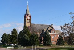 | Immaculate Conception Catholic Church and Rectory | building | 2001 | 01000711 |
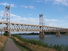 | Meridian Bridge | structure | 1993 | 93000537 |
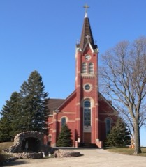 | Saints Peter and Paul Catholic Church Complex | building | 2000 | 00000765 |
 | Saints Philip and James Parochial School | building | 2003 | 03001211 |
 | St. Boniface Catholic Church Complex | building | 1983 | 83001081 |
Every wildfire the federal occurrence database records inside this county: 87 of them, burning about 577 acres. 4 started naturally and 1 was recorded as arson. Each settlement page carries the fires within five miles of it.
| Reported cause | Fires |
|---|---|
| Debris and open burning | 30 |
| Equipment and vehicle use | 20 |
| Missing data/not specified/undetermined | 19 |
| Smoking | 7 |
| Natural | 4 |
| Power generation/transmission/distribution | 3 |
| Fireworks | 2 |
| Arson/incendiarism | 1 |
| Railroad operations and maintenance | 1 |
The five largest, by the area the report gives. None of them was recorded as arson.
| Date | Cause | Size | Reported by | Name on the report |
|---|---|---|---|---|
| 16 April 2002 | Natural | 80 acres | Nebraska Forest Service | not named |
| 28 April 2007 | Debris and open burning | 65 acres | Nebraska Forest Service | not named |
| 15 April 2008 | Debris and open burning | 60 acres | Nebraska Forest Service | not named |
| 26 October 2015 | Equipment and vehicle use | 30 acres | Nebraska Forest Service | not named |
| 6 October 2011 | Equipment and vehicle use | 25 acres | Nebraska Forest Service | not named |
| 28 October 2015 | Equipment and vehicle use | 25 acres | Nebraska Forest Service | not named |
| 1 February 2019 | Debris and open burning | 25 acres | Nebraska Forest Service | not named |
| 11 April 2011 | Debris and open burning | 25 acres | Nebraska Forest Service | not named |
Every settlement page carries the fires within five miles of it - see the settlement index below.
The NOAA Storm Events Database holds 389 reports for this county, causing 1 death, 6 injuries and about $12,844,000 in recorded property damage. Each settlement page carries the reports that name it.
| Kind of event | Reports |
|---|---|
| Hail | 197 |
| Thunderstorm Wind | 133 |
| Tornado | 31 |
| Flash Flood | 13 |
| Flood | 7 |
| Funnel Cloud | 4 |
| Lightning | 2 |
| Heavy Rain | 2 |
The most serious of them, by death, then injury, then recorded damage. The accounts are quoted exactly as the forecast office filed them.
| When | Event | Place named | Harm | What the report says |
|---|---|---|---|---|
| June 2003 | Tornado (F4) | Coleridge | 1 killed, $3,700,000 | An eventual f4 tornado began its destructive path around 6 miles southwest of Coleridge. The tornado moved northeast and crossed the northern sections of the city uprooting trees, downing power lines and destroying a couple of grain bins. A construction business in a garage was also destroyed. The tornado then continued northeast of town hitting a large hog farm. At this farm a 70-year-old man was killed while in a storage shed when a tractor that was flipped by the winds crushed him. Many livestock were also killed by debris or flung through the air by the deadly winds. In one case cattle were carried over a mile then left dead in a pile. The tornado then widened to around 3/4 of a mile, reaching its maximum intensity. Numerous vehicles were tossed at this location and a complete farmstead was flattened. Trees were also stripped and debarked. The tornado remained around 3/4 of a mile wide for a few more miles before turning slightly to the southeast and diminishing, but not before hitting 2 more farmsteads and moving one house off of its foundation. In total, 11 homes received substantial damage and between 100 and 200 utility poles were downed. |
| June 1953 | Tornado (F2) | not stated | 4 hurt, $25,000 | no account filed |
| May 1962 | Tornado (F3) | not stated | 1 hurt, $2,500,000 | no account filed |
| May 1998 | Tornado (F2) | Coleridge | 1 hurt | Three farms damaged. Eight to ten power poles downed 8 -10 miles east southeast of Hartington. Injury occurred about 9 miles east of Hartington southeast of the Highway 84/57 interchange. |
| May 1992 | Tornado (F2) | not stated | $2,500,000 | no account filed |
| June 2014 | Tornado (EF3) | Coleridge | $2,000,000 | This was the strongest of the tornadoes that the Cedar County supercell produced. This tornado developed to the northwest of Coleridge and moved slowly east southeast just to the north of the city of Coleridge. As the tornado neared 567th Ave the tornado turned to the south along the eastern edge of the city producing some significant structural damage along the eastern side of Coleridge. The tornado continued south until nearing 875th Road where the foward speed further slowed, and the tornado changed to an eastern movement while becoming rain-wrapped. The eastern direction occurred for a half mile before the tornado moved almost due north along 568th Ave while significantly weakening. The most significant damage, which was strong EF3, occurred to the north of Coleridge along the 876th Road. Here, two farm houses were destroyed down to the foundation and trees were snapped and debarked. The total path of the tornado, including all the turns, was 8.24 miles. |
| June 2014 | Tornado (EF2) | Laurel | $250,000 | This was the final tornado in the Cedar County event. This tornado initially moved southwest while increasing in intensity and width. The tornado produced the most significant damage as it turned south along 573rd Ave where the tornado impacted a farm where outbuildings were completely destroyed. The tornado continued south crossing United States Highway 20. The tornado started to turn southeast about 1.5 miles northeast of Laurel. The tornado continued southeast producing mainly tree and power line damage before crossing into Dixon County near 869th Road. The complete track of the tornado was 8.04 miles. |
| June 1963 | Tornado (F2) | not stated | $250,000 | no account filed |
| June 1960 | Tornado | not stated | $250,000 | no account filed |
| May 1959 | Tornado (F2) | not stated | $250,000 | no account filed |
| June 2014 | Flash Flood | Hartington | $200,000 | The nearly stationary supercell over Cedar County produced very heavy rain and flash flooding. Flooding was reported over State Highway 57 south of Hartington. In addition to this flooding, numerous secondary gravel roads were flooded and impassable during the late evening on June 17th from torrential rains. |
| July 1999 | Flash Flood | Hartington | $150,000 | Rainfall of 9.5 to 10.5 inches fell on the Hartington area in two days, 7/19 and 7/20/99 with lesser amounts across the rest of Cedar county. The 2nd day of rain caused the most damage due to flash flooding with 2 county bridges destroyed and highways 12 and 81 northwest of Hartington flooded. Damage was sustained along the Norwegian Bow Creek and the West Bow Creek. Besides bridge and road damage, several homes were flooded. Later in the afternoon on the 21st, high water along the West Bow Creek approached Bow Valley and Wynot flowing over some gravel roads and forcing sandbagging of several homes. |
| September 1997 | Thunderstorm Wind | Coleridge | $110,000 | Thunderstorm winds destroyed a center pivot and a tree fell and destroyed a shed 3 miles northeast of Coleridge. The strong winds also damaged portion of a hog building 5 miles northeast of Coleridge. |
| September 1997 | Lightning | Hartington | $75,000 | Lightning struck power lines outside a telephone company facility. The resulting power surge did significant damage to telphone equipment at the facility. |
| July 1998 | Thunderstorm Wind | Randolph | $70,000 | 50 X 80 foot honey storage barn on the west side of Randolph was destroyed. Roof on the Randolph High School was damaged. |
| June 2014 | Tornado (EF2) | Laurel | $50,000 | This short-lived tornado traveled to the east and impacted two farmsteads along 873rd Road. One of these farms had significant damage where large portions of the roof of the home were removed and outbuildings were completely destroyed. |
| July 2009 | Flash Flood | Wynot | $50,000 | Thunderstorms dropped very heavy rain in the Wynot area which produced areas of flash flooding. The cooperative observer near Wynot reported 3.55 inches of rain in a several hour period during the morning of July 9th. The flooding was observed across several county roads and Highway 12 near Wynot. Gravel was washed off of a few roads and some culvert damage was noted. |
| May 1999 | Tornado (F1) | Hartington | $50,000 | Farm buildings were heavily damaged as well as a garage, part of a roof of a house and part of a center irrigation pivot. |
| August 1993 | Thunderstorm Wind | Coleridge | $50,000 | Winds destroyed a carport in Coleridge. A large grain bin was also damaged south of town. |
| August 2000 | Thunderstorm Wind | Bow Vly | $35,000 | An apparent thunderstorm microburst destroyed a dairy barn near Bow Valley. Four dairy cattle were killed when the barn roof fell on them. The storm took a door off a machine shed and destroyed 6 calf huts also. The farm house, which was only 150 feet away from the barn, was not damaged. |
| July 1996 | Lightning | Laurel | $30,000 | no account filed |
| June 2014 | Tornado (EF1) | Laurel | $25,000 | This was the first of 3 tornadoes that developed to the north of the Laurel area. This tornado was a large multi-vortex tornado. Video from storm chasers indicate that the tornado had vorticities that moved in varying directions, but the overall movement of the tornado was to the west southwest at a very slow pace. Although the tornado circulation was large, the slow movement of the tornado limited the potential damage. This included tree limbs and power poles, but one farmstead was impacted along Highway 15 where the house lost part of the roof and outbuildings were heavily damaged. |
| May 1996 | Thunderstorm Wind | Coleridge | $25,000 | no account filed |
| June 1992 | Tornado (F1) | not stated | $25,000 | no account filed |
| June 1984 | Tornado (F1) | not stated | $25,000 | no account filed |
| July 1973 | Tornado (F0) | not stated | $25,000 | no account filed |
| August 1964 | Tornado (F2) | not stated | $25,000 | no account filed |
| July 2011 | Flood | Aten | $20,000 | Flooding along the Missouri River gradually worsened over the area during June and continued through July as record releases from Gavins Point Dam brought lowland flooding along the River. In Cedar county the flooding generally began during the first week of the June as flows out of Gavins Point Dam reached and exceeded 100,000 cfs. The flooding grew worse as the discharge reached 160,000 cfs by the end of June and these high releases continued through July before moderating a bit. A few seasonal or permanent homes were threatened by the flood waters, but in general the flooding was confined to low areas and farmland along the river. The flooding continued into August. |
| June 2011 | Flood | Aten | $15,000 | Flooding along the Missouri River gradually worsened over the area during June as record releases from Gavins Point Dam brought areas of lowland flooding along the river. In Cedar county the flooding generally began during the first week of the month as flows out of Gavins Point Dam reached and exceeded 100,000 cfs on the way to 160,00 cfs. A few seasonal or permanent homes were threatened by the flood waters, but in general the flooding was confined to low areas and farmland along the river. The flooding continued into July. |
| May 1999 | Tornado (F0) | Belden | $15,000 | A barn and farm equipment were destroyed. |
| June 2014 | Tornado (EF1) | Hartington Muni Arpt | $10,000 | This was the first of 3 tornadoes near the Coleridge area on the evening of June 17th. The tornado moved southeast and impacted a farm along 878th Road and 561st Ave where outbuildings were heavily damaged. Otherwise mainly tree damage was observed along the path of the tornado. |
| July 1997 | Thunderstorm Wind | Hartington | $10,000 | no account filed |
| July 1996 | Thunderstorm Wind | Coleridge | $10,000 | no account filed |
| August 2011 | Flood | Aten | $5,000 | Flooding along the Missouri River gradually worsened over the area during June and July and continued into August before improving by the end of that month as record releases from Gavins Point Dam brought lowland flooding along the River. In Cedar county the flooding generally began during the first week of the June as flows out of Gavins Point Dam reached and exceeded 100,000 cfs. The flooding grew worse as the discharge reached 160,000 cfs by the end of June and these high releases continued into early August before moderating, especially by the end of the month. A few seasonal or permanent homes were threatened by the flood waters, but in general the flooding was confined to low areas and farmland along the river. The flooding continued into September. |
| August 1993 | Thunderstorm Wind | Belden | $5,000 | Strong thunderstorm winds damaged outbuildings and trees. |
| May 1993 | Thunderstorm Wind | Coleridge | $5,000 | Thunderstorm winds heavily damaged two building on the east side of town. |
| August 1975 | Tornado (F0) | not stated | $2,500 | no account filed |
| September 2011 | Flood | Aten | $1,000 | Flooding along the Missouri River, which had gradually worsened over the area during June and July, started improving in August and basically ended by mid September. The flooding was caused by record releases out of Gavins Point Dam which reached around 160,000 cfs by the end of June. These releases were cut way back in late August and even more by mid September due to decreased inflows into the river system. A few seasonal or permanent homes were threatened by the flood waters, but in general the flooding was confined to low areas and farmland along the river. |
| July 1986 | Tornado (F0) | not stated | $250 | no account filed |
| May 1959 | Tornado (F0) | not stated | $250 | no account filed |
| March 2026 | Hail | Belden | - | Public report of hail measured at 2.50 inch in diameter received via an image on social media. |
| June 2025 | Hail | Hartington | - | Emergency manager report of hail measured up to 1 in diameter. |
| June 2025 | Thunderstorm Wind | Laurel | - | Emergency management report of irrigation flipped two miles south of Laurel along with power lines down in that area. Time estimated with radar. |
| June 2025 | Thunderstorm Wind | Fordyce | - | Measured wind gust of 58 mph from a mesonet. |
| June 2025 | Thunderstorm Wind | Fordyce | - | Measured wind gust of 63 mph from a mesonet. |
| April 2025 | Hail | Fordyce | - | Public caller reported lots of hail falling down with the largest being ping pong ball sized. |
| July 2025 | Hail | Belden | - | Public report of hail estimated up to quarter sized mixed in with dime sized hail. |
| July 2025 | Hail | St James | - | Public report of hail measured up to 1.75 inch in diameter. |
| July 2025 | Hail | St James | - | Public report of hail estimated at 3 to 3.5 inch in diameter. |
| April 2024 | Flash Flood | Belden | - | The Cedar County EM reported water over Highway 20 just to the east of Belden. |
| April 2024 | Hail | Hartington | - | The office received a public report of 1 inch hail. |
| May 2024 | Hail | Hartington | - | The office received a report from the 911 Call Center for golfball sized hail 2 miles to the northwest of Hartington, NE. |
| May 2024 | Hail | Fordyce | - | A report of half dollar sized hail was relayed to the office by the 911 Call Center. |
| May 2024 | Hail | Hartington | - | The office received a report from social media of golfball sized hail that fell in far eastern Cedar County, Nebraska. |
| July 2024 | Thunderstorm Wind | Fordyce | - | A personal weather station recorded a 65 miles per hour wind gust. |
| July 2024 | Thunderstorm Wind | Laurel | - | The office received a photo on social media of tree damage. The time was estimated from radar. |
| July 2024 | Thunderstorm Wind | Hartington | - | A trained spotter reported a 71 miles per hour wind gust. |
| July 2024 | Thunderstorm Wind | Fordyce | - | A mesonet recorded a 63 miles per hour wind gust. |
| July 2024 | Thunderstorm Wind | Wynot | - | Multiple 3-inch tree branches were reported down in the town of Wynot, Nebraska. |
| July 2024 | Flash Flood | Fordyce | - | The office received a report from a trained spotter of water flowing over several roads including 888th road near Fordyce. |
The Survey's mineral resources record lists 2 workings inside this county. All of them still produce. Each settlement page carries the workings within five miles of it.
| Commodity | Workings |
|---|---|
| Sand and Gravel, Construction | 2 |
The least common of them first, because a county's hundredth gravel pit says nothing its first ten did not.
| Where | Site | Commodity | Status | Recorded |
|---|---|---|---|---|
| Backus Sand and Gravel | Sand and Gravel, Construction | Producer | ||
| Ronald Liese Pit & Plant | Sand and Gravel, Construction | Producer |
Named settlements recorded in the Geographic Names Information System, each with the topographic sheets covering it. Villages, hamlets and abandoned places alike. Each is shown with the nearest named watercourse or landform and the survey quadrangle it falls on.
Precinct 5 · 68792 · On Second Bow Creek · Saint Helena quadrangle
10 sheets, 1955 to 1994