 Block
From the record
6 National Register listings published here.
Sources: the National Register database, National Park Service
33 topographic sheets cover 9 settlements here, and 6 properties are on the National Register of Historic Places.
6 National Register listings published here.
Sources: the National Register database, National Park Service
Every property in this county listed on the National Register of Historic Places, with the year it was listed and the federal nomination document.
| Photograph | Property | Type | Listed | Reference |
|---|---|---|---|---|
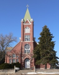 | Church of the Visitation of the Blessed Virgin Mary | building | 1984 | 84002472 |
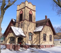 | First Presbyterian Church | building | 2004 | 04000292 |
 | Greeley County Courthouse | district | 1990 | 89002228 |
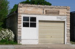 | Scotia Chalk Building | building | 1979 | 79003686 |
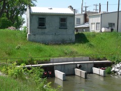 | Spalding Power Plant and Dam | district | 1998 | 98001569 |
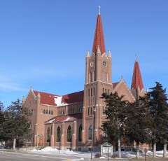 | St. Michael's Catholic Church Complex | building | 1983 | 83003990 |
Every wildfire the federal occurrence database records inside this county: 26 of them, burning about 692 acres. 2 started naturally and none was recorded as arson. Each settlement page carries the fires within five miles of it.
| Reported cause | Fires |
|---|---|
| Missing data/not specified/undetermined | 9 |
| Debris and open burning | 8 |
| Equipment and vehicle use | 7 |
| Natural | 2 |
The five largest, by the area the report gives. None of them was recorded as arson.
| Date | Cause | Size | Reported by | Name on the report |
|---|---|---|---|---|
| 11 March 2011 | Debris and open burning | 250 acres | Nebraska Forest Service | not named |
| 17 April 2014 | Debris and open burning | 200 acres | Nebraska Forest Service | not named |
| 6 March 2017 | Debris and open burning | 80 acres | Nebraska Forest Service | not named |
| 30 July 2006 | Equipment and vehicle use | 40 acres | Nebraska Forest Service | not named |
| 5 November 2014 | Equipment and vehicle use | 40 acres | Nebraska Forest Service | not named |
| 13 March 2008 | Equipment and vehicle use | 30 acres | Nebraska Forest Service | not named |
| 21 April 2009 | Debris and open burning | 25 acres | Nebraska Forest Service | not named |
| 28 July 2005 | Natural | 7.0 acres | Nebraska Forest Service | not named |
Every settlement page carries the fires within five miles of it - see the settlement index below.
The NOAA Storm Events Database holds 246 reports for this county, causing no deaths, 12 injuries and about $12,777,780 in recorded property damage. Each settlement page carries the reports that name it.
| Kind of event | Reports |
|---|---|
| Hail | 134 |
| Thunderstorm Wind | 71 |
| Tornado | 24 |
| Heavy Rain | 8 |
| Flash Flood | 7 |
| Funnel Cloud | 1 |
| Flood | 1 |
The most serious of them, by death, then injury, then recorded damage. The accounts are quoted exactly as the forecast office filed them.
| When | Event | Place named | Harm | What the report says |
|---|---|---|---|---|
| May 1964 | Tornado (F4) | not stated | 11 hurt, $25,000 | no account filed |
| June 1953 | Tornado (F2) | not stated | 1 hurt, $25,000 | no account filed |
| July 2004 | Thunderstorm Wind | Countywide | $3,500,000 | A severe thunderstorm produced 90 mph winds and large hail across Greeley county. Widespread property and crop damage was reported. |
| March 2019 | Flood | Scotia | $2,000,000 | no account filed |
| April 2012 | Hail | Spalding | $1,000,000 | Hail the size of hen eggs damaged a law enforcement vehicle. There were also reports from north of Spalding of hail causing roof and siding damage, breaking windows out of homes and buildings, and vehicle damage. |
| June 2024 | Thunderstorm Wind | Greeley | $750,000 | Wind gusts estimated to be near 80 MPH resulted in a long swath of damage in Greeley and Nance counties. Report from social media noted this swath was approximately 6 to 8 miles wide. Widespread tree damage was reported, including large limbs downed and trunks split, as well as several flipped irrigation pivots. The combination of wind and hail caused widespread crop damage in the area. |
| June 2024 | Thunderstorm Wind | Scotia | $500,000 | Wind gusts estimated to be near 80 MPH caused widespread damage in eastern Valley and western Greeley counties. Along with tree damage, a handful of power poles were snapped, and several irrigation pivots were flipped. A number of grain bins and outbuildings were damaged, and a home north of North Loup suffered siding damage and also had a couple of trailers shifted from their parked spots. |
| April 2012 | Hail | Spalding | $500,000 | no account filed |
| April 2024 | Tornado (EF2) | Wolbach | $400,000 | Through a roughly 10 minute process, during which the parent supercell did not move much, a fourth tornado formed in northern Howard County before crossing into Greeley County. This tornado was rated an EF2 with estimated peak wind speeds of 135 MPH based upon metal power pole damage just west of the Highway 281 and 22 junction near Wolbach. The tornado had previously destroyed a metal building to the southwest, and would go on to destroy a couple of wood framed outbuildings to the northeast of Highway 281. The south edge of the tornado likely passed just north of the Highway 281 and 22 junction. It was in this general area and along the county line that the tornado was at least one-half mile wide. The tornado marched northeast, causing damage to at least one residence, outbuildings, trees, and center irrigation pivots. As the supercell slowed down north of Wolbach, this tornado diminished (damage noted was much less severe and sparse), and the supercell began the process of developing another tornado to the east. |
| June 2024 | Flash Flood | Wolbach | $300,000 | Based on radar estimation and various measured totals from NWS/NeRAIN/CoCoRaHS observers, widespread rainfall of 2-6 inches fell within primarily the southern two-thirds of the county mainly between 7 p.m. CDT on the 21st and 1 a.m. CDT on the 22nd. |
| May 2023 | Tornado (EF1) | Spalding | $300,000 | This tornado developed out of a northwestward tracking supercell that was located within a band of supercells that were rotating around a strong low pressure system over central Nebraska. The tornado formed right around 2:25 PM CDT and tracked over open pasture and recently planted fields mainly hitting several pivots and tree lines as it tracked northwest. No homes were impacted by this tornado. The worst damage appeared to be the flipped pivots, snapped cedar trees, and finally damage to at least 2 parked vehicles at the intersection of Highway 91 and Highway 281. The windows were blown out on two vehicles that were parked at this location and two large metal electrical transmission poles were leaning, but still standing at this intersection. After hitting the Highway 91 and 281 intersection the tornado continued onto the northwest over open road-less country across far north central Greeley county where based on video and surveying, it was believed to have lifted just shy of the Greeley/Wheeler County line. The maximum wind gust was estimated to be 105 MPH. |
| October 2013 | Heavy Rain | Wolbach | $250,000 | A rainfall total of 8.46 inches occurred. |
| June 2010 | Flash Flood | Belfast | $250,000 | no account filed |
| April 1979 | Tornado | not stated | $250,000 | no account filed |
| April 1974 | Tornado (F2) | not stated | $250,000 | no account filed |
| June 2011 | Thunderstorm Wind | Spalding | $160,000 | Wind gusts estimated at 80 MPH knocked over at least 2 irrigation pivots, destroyed a small grain bin and damaged a few power poles and trees. |
| July 2018 | Hail | Scotia | $100,000 | Hail up the size of half dollars was reported. |
| July 2006 | Thunderstorm Wind | Greeley | $100,000 | no account filed |
| July 2003 | Thunderstorm Wind | Countywide | $100,000 | no account filed |
| May 1998 | Hail | Greeley | $80,000 | no account filed |
| May 1998 | Hail | Wolbach | $80,000 | no account filed |
| August 1997 | Hail | Greeley | $80,000 | no account filed |
| June 2014 | Thunderstorm Wind | Scotia | $75,000 | Considerable damage occurred to outbuildings and house windows were broken. |
| June 2014 | Thunderstorm Wind | Wolbach | $75,000 | The roof was peeled back from a grocery store in Wolbach. There was a lot of tree damage as well. |
| April 2003 | Tornado (F0) | Greeley | $75,000 | The severe thunderstorm which had spawned some brief tornados earlier was to blame for a short path tornado centered about 6 miles north of Greeley. The tornado upset 2 center irrigation pivots and damaged a shelter belt. |
| September 2019 | Hail | Scotia | $75,000 | no account filed |
| August 2023 | Hail | Greeley | $50,000 | Hail up to the size of quarters, driven by wind gusts of unknown speed, resulted in damage to a corn field. |
| June 2021 | Thunderstorm Wind | Greeley | $50,000 | Tree damage reported across town. Trees up to two feet in diameter were downed. |
| February 2012 | Tornado (EF0) | Greeley | $50,000 | A weak tornado, with peak winds estimated at 70 mph, briefly touched down west of Greeley. Damage was confined to an overturned pivot. |
| May 2004 | Flash Flood | Greeley | $50,000 | Three inches of rain fell east of Greeley and washed out country roads and crops in the area. |
| May 1993 | Thunderstorm Wind | not stated | $50,000 | Sixty mph winds were measured three miles east of Wolbach. Winds blew over a 12 foot by 30 foot cattle shed. Power lines and trees were knocked down and the roof was damaged on a house. |
| August 1993 | Thunderstorm Wind | Greeley | $50,000 | Thunderstorm winds of 65 to 70 mph caused considerable damage to trees in Greeley. |
| June 2010 | Flash Flood | Scotia Muni Arpt | $50,000 | no account filed |
| August 2004 | Hail | Spalding | $50,000 | no account filed |
| June 1997 | Thunderstorm Wind | Wolbach | $50,000 | no account filed |
| May 2013 | Tornado (EF1) | Wolbach | $40,000 | This tornado touched down a few miles northeast of Wolbach and was on the ground for approximately 2 minutes. With an estimated top wind speed of 90 mph, damage from this tornado included a destroyed mobile home and outbuilding and broken tree limbs of 5 to 8 inches in diameter. |
| April 2003 | Tornado (F0) | Spalding | $40,000 | Another tornado set down west of Spalding and overturned a brand new center irrigation pivot in its path. |
| July 1995 | Thunderstorm Wind | Wolbach | $40,000 | no account filed |
| June 1997 | Hail | Scotia | $30,000 | no account filed |
| June 1997 | Hail | Scotia | $30,000 | no account filed |
| April 2024 | Tornado (EF2) | Wolbach | $25,000 | This tornado started about four miles northeast of Wolbach and was associated with a parent supercell that had previously produced two other tornadoes. In Greeley County, damage was confined mainly to center irrigation pivots and trees. The tornado moved northeast over open country and crossed the Boone County line along Highway 56. In Boone County, the tornado caused minor damage to a home on a farmstead at the county line along with quite a bit of tree damage in the general area. The tornado moved north and appeared to strengthen some as it flipped and tossed several central irrigation pivots north of Highway 56. Power poles were snapped and debris was lifted into power lines. As the tornado moved north-northeast, the most significant damage was found about two miles southwest of Primrose. A single-family home was extensively damaged, including the three-car garage being totally ripped away along with much of the roof structure. Several outbuildings were damaged or destroyed. Extensive tree damage and numerous power poles were snapped in the area. Tree damage was widespread west of Primrose and one large outbuilding was destroyed. In its final few miles, the tornado damaged trees and irrigation pivots in several places. Extensive damage to a livestock facility and several snapped power poles were noted about halfway between Primrose and Petersburg. The tornado likely dissipated in open country as it approached the Beaver Creek southwest of Petersburg. The widest point of the tornado appeared to occur just to the west and southwest of Primrose when the tornado may have been at least 500 yards wide. The EF2 rating and estimated maximum wind speed of 130 MPH was based upon the damage that occurred at a home southwest of Primrose. Note: The dollar estimate of damage applies to Greeley County only. |
| June 2015 | Hail | Wolbach | $25,000 | Quarter to half dollar size hail occurred...report relayed by broadcast media. |
| June 2014 | Thunderstorm Wind | Scotia | $25,000 | A truck with a utility trailer flipped over on Highway 22. This occurred from a rear flank downdraft. No injuries occurred. This report came from the Spotter Network. |
| June 2014 | Hail | Spalding | $25,000 | A trained spotter reported golf ball sized hail fell in Spalding. |
| June 2014 | Thunderstorm Wind | Spalding | $25,000 | A tree fell onto an SUV. This report was received via social media. |
| October 2013 | Hail | Greeley | $25,000 | Quarter to golf ball size hail occurred with some rain. |
| May 2012 | Thunderstorm Wind | Greeley | $25,000 | Small tree branches were blown down at a home and hail of unknown size resulted in broken house windows and a broken windshield. |
| August 2012 | Hail | Wolbach | $25,000 | Hail up to the size of quarters started falling around 520 pm CDT and continued to fall until about 550 pm CDT. The ground was completely covered with hail and visibility was poor as the hail fell. |
| August 2012 | Hail | Wolbach | $25,000 | Hail up to the size of golf balls fell, resulting in a shattered windshield 3 miles northwest of Wolbach. |
| July 2011 | Thunderstorm Wind | Scotia | $25,000 | Wind gusts were estimated at 60 MPH. A shed was damaged when its roof was blown off and one wall fell, and a picnic shelter roof at the park was destroyed. Crop damage was also reported in the area. |
| July 2011 | Thunderstorm Wind | Greeley | $25,000 | Tree limbs were blown down in Greeley, with one falling onto and damaging a vehicle. Crop damage was also reported in the area. |
| May 2012 | Hail | Spalding | $25,000 | no account filed |
| May 2012 | Hail | Scotia | $25,000 | no account filed |
| August 2012 | Hail | Wolbach | $25,000 | no account filed |
| June 2011 | Hail | Scotia | $25,000 | no account filed |
| August 2007 | Thunderstorm Wind | Wolbach | $25,000 | no account filed |
| July 2006 | Hail | Wolbach | $25,000 | no account filed |
| April 2005 | Hail | Wolbach | $25,000 | no account filed |
| May 1973 | Tornado (F0) | not stated | $25,000 | no account filed |
| July 2006 | Hail | Greeley | $20,000 | no account filed |
Named settlements recorded in the Geographic Names Information System, each with the topographic sheets covering it. Villages, hamlets and abandoned places alike. Each is shown with the nearest named watercourse or landform and the survey quadrangle it falls on.
Scotia precinct · 68875 · On Wallace Creek · Scotia quadrangle
12 sheets, 1899 to 1985
Wolbach precinct · 68882 · On West Branch Spring Creek · Wolbach quadrangle
13 sheets, 1899 to 1985