 Block
From the record
5 National Register listings published here.
Sources: the National Register database, National Park Service
30 topographic sheets cover 12 settlements here, and 5 properties are on the National Register of Historic Places.
5 National Register listings published here.
Sources: the National Register database, National Park Service
Every property in this county listed on the National Register of Historic Places, with the year it was listed and the federal nomination document.
| Photograph | Property | Type | Listed | Reference |
|---|---|---|---|---|
 | Columbia Hall | building | 2005 | 05000724 |
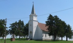 | Dannevirke Danish Lutheran Church and Community Hall | building | 1999 | 99000750 |
 | Howard County Courthouse | district | 1990 | 89002233 |
| Our Lady of Mount Carmel Church and Cemetery | district | 2020 | 100005769 | |
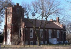 | St. Peder's Dansk Evangelical Lutheran Kirke | building | 2007 | 07000177 |
Every wildfire the federal occurrence database records inside this county: 26 of them, burning about 319 acres. 2 started naturally and none was recorded as arson. Each settlement page carries the fires within five miles of it.
| Reported cause | Fires |
|---|---|
| Debris and open burning | 10 |
| Equipment and vehicle use | 7 |
| Missing data/not specified/undetermined | 5 |
| Natural | 2 |
| Power generation/transmission/distribution | 2 |
The five largest, by the area the report gives. None of them was recorded as arson.
| Date | Cause | Size | Reported by | Name on the report |
|---|---|---|---|---|
| 5 October 2011 | Equipment and vehicle use | 162 acres | Nebraska Forest Service | not named |
| 12 April 2011 | Debris and open burning | 60 acres | Nebraska Forest Service | not named |
| 24 July 2017 | Debris and open burning | 25 acres | Nebraska Forest Service | not named |
| 29 April 2011 | Natural | 20 acres | Nebraska Forest Service | not named |
| 26 August 2004 | Missing data/not specified/undetermined | 10 acres | Nebraska Forest Service | not named |
| 7 April 2017 | Equipment and vehicle use | 10 acres | Nebraska Forest Service | not named |
| 27 March 2013 | Equipment and vehicle use | 6.0 acres | Nebraska Forest Service | not named |
| 29 March 2013 | Debris and open burning | 5.0 acres | Nebraska Forest Service | not named |
Every settlement page carries the fires within five miles of it - see the settlement index below.
The NOAA Storm Events Database holds 414 reports for this county, causing no deaths, 27 injuries and about $61,642,250 in recorded property damage. Each settlement page carries the reports that name it.
| Kind of event | Reports |
|---|---|
| Hail | 234 |
| Thunderstorm Wind | 96 |
| Tornado | 45 |
| Flash Flood | 11 |
| Flood | 11 |
| Heavy Rain | 9 |
| Funnel Cloud | 5 |
| Lightning | 3 |
The most serious of them, by death, then injury, then recorded damage. The accounts are quoted exactly as the forecast office filed them.
| When | Event | Place named | Harm | What the report says |
|---|---|---|---|---|
| April 1984 | Tornado (F3) | not stated | 18 hurt, $25,000,000 | no account filed |
| May 1964 | Tornado (F2) | not stated | 7 hurt, $25,000 | no account filed |
| August 1974 | Tornado (F1) | not stated | 2 hurt, $250,000 | no account filed |
| May 1993 | Tornado (F1) | Ashton to | $5,000,000 | Tornado touched down just northeast of Ashton. Two center pivots were destroyed. A house roof, barn and grain bins were damaged. Tornado was last seen two miles west of Coatsville. |
| April 2024 | Tornado (EF3) | Farwell | $3,500,000 | Initially narrow, this tornado started south of Farwell with eyewitness reports, and would eventually turn into a large, EF3-rated tornado. The tornado moved across rural areas north of Farwell, causing tree damage and overturning center irrigation pivots. As the tornado emerged onto the North Loup River valley just west of Elba, it gained significant strength. Just west of Elba, a farmstead sustained heavy damage to a home, outbuildings and vehicles, among other items. A well-built metal building structure was was demolished, with extensive damage to the nearby home. Based upon damage indicators, this location was deemed to have the strongest winds, estimated to be 145 MPH, resulting in the EF3 rating. The tornado was estimated to be around 600 yards wide as it crossed Highway 11 just northwest of Elba. A long stretch of power poles was knocked down along Odell Road. The tornado eventually navigated across the North Loup River about 2.5 miles north of town. From that point, the tornado moved onto pasture ground. Based upon radar data, timing and lack of solid damage indicators, it is believed this tornado likely weakened as it moved north. |
| March 2019 | Flood | Cushing | $3,000,000 | no account filed |
| March 2019 | Flood | Cotesfield | $3,000,000 | no account filed |
| March 1990 | Tornado (F3) | not stated | $2,500,000 | no account filed |
| June 1984 | Tornado (F3) | not stated | $2,500,000 | no account filed |
| May 2012 | Hail | St Paul | $2,000,000 | Hail ranging from the size of quarters to at least the size of baseballs was reported in and around St. Paul. There were numerous reports of vehicle damage, along with window, siding, and gutter damage to homes. A local greenhouse had 21 roof panels destroyed. |
| May 2005 | Flash Flood | South Portion | $2,000,000 | no account filed |
| July 2022 | Hail | Farwell | $1,000,000 | Hail up to the size of golf balls was reported in Farwell by an NWS Employee. Emergency management later reported that a swath approximately three miles wide running from the Farwell area to west of Dannebrog suffered widespread crop damage and broken windows and siding. |
| March 2019 | Flash Flood | Dannebrog | $1,000,000 | no account filed |
| June 2024 | Flash Flood | Boelus | $600,000 | Based on radar estimation and various totals from NWS/NeRAIN/CoCoRaHS observers, widespread rainfall of 3-6 inches (localized 7+ inches) fell across most of the county mainly between 7 p.m. CDT on the 21st and 12:30 a.m. CDT on the 22nd. A river gage along the Turkey Creek north of Dannebrog registered a record crest of 21.63 feet (flood stage 17.0') on the morning of the 22nd. Emergency management reported numerous rural roads under water and an evacuation was needed at one farmstead northwest of Dannebrog. Other area creeks and streams flooded, including the Dry and Oak Creeks. The flooding of Oak Creek had a significant impact in Dannebrog, closing Highway 58, flooding the park and several streets, and causing a few homes to need sandbagged. In all, a reported seven homes received water damage and 14 city blocks flooded, causing $50,000 in city infrastructure damage. Per county officials, 60 miles of county roads were damaged at an estimated cost of $393,000. In addition, 11 bridges were damaged with an estimated repair at $275,000. |
| May 2024 | Flood | Cotesfield | $500,000 | Following the 2 to 5 inches that fell across the area on the 30th, another round of showers and thunderstorms brought an additional 1 to 2 inches of rain to the area during the early afternoon hours of the 31st. Numerous rural roads remained closed, and some bridges were washed out. Farwell was accessible only by rural roads, as the main paved entry into town remained covered in water. At least one resident was unable to access their home for a period of time due to the floodwaters. Emergency management reported that one resident who lived along Turkey Creek had to be evacuated from their home. The automated gauge on Turkey Creek showed a rapid rise on the 30th, reaching its flood stage of 17.0 feet around 10:45 AM CDT on the 30th. It remained in or near flood stage on into the evening of the 31st, peaking at a stage of 20.4 feet around 5 PM CDT on the 30th, stopping just below its record stage of 20.74 feet from March of 2019. |
| May 2024 | Flash Flood | Cotesfield | $500,000 | Radar estimates and local reports showed that between 2 and 5 inches of rain fell across the area, mostly in a period of two hours from approximately 7AM to 9AM. The highest amounts occurred in central and west-central portions of Howard County. Emergency management and law enforcement reported that water was covering parts of Highway 92 in the Farwell area as well as parts of Highway 11 in the Elba area. Water was running over rural roads, and numerous rural roads ended up being closed. Small creeks were flooded, with this water eventually making into and flooding the Turkey Creek, which runs north of Dannebrog and eventually into the Middle Loup River. |
| July 2022 | Hail | Elba | $500,000 | Hail up to the size of baseballs was reported. A CoCoRaHS observer noted in comments that crops and trees were damaged and did not look good. |
| July 2022 | Thunderstorm Wind | Farwell | $500,000 | Wind gusts estimated to be at least 70 MPH resulted in tree and crop damage in the area, as well as overturned pivots. |
| June 2003 | Hail | St Libory | $500,000 | no account filed |
| April 2024 | Tornado (EF2) | Elba | $400,000 | Through a roughly 10 minute process, during which the parent supercell did not move much, a fourth tornado formed in northern Howard County before crossing into Greeley County. This tornado was rated an EF2 with estimated peak wind speeds of 135 MPH based upon metal power pole damage just west of the Highway 281 and 22 junction near Wolbach. The tornado had previously destroyed a metal building to the southwest, and would go on to destroy a couple of wood framed outbuildings to the northeast of Highway 281. The south edge of the tornado likely passed just north of the Highway 281 and 22 junction. It was in this general area and along the county line that the tornado was at least one-half mile wide. The tornado marched northeast, causing damage to at least one residence, outbuildings, trees, and center irrigation pivots. As the supercell slowed down north of Wolbach, this tornado diminished (damage noted was much less severe and sparse), and the supercell began the process of developing another tornado to the east. |
| August 2018 | Hail | Farwell | $325,000 | The combination of hail up to the size of golf balls and wind gusts of 60-75 MPH resulted in damage across central/southern Howard County. Most of the hail reports were dime to quarter size, with one report of golf ball hail north of Dannebrog, but a common theme was the copious amounts of hail. In a few spots, hail drifts were ankle-knee high. There were many reports of significant crop damage extending from around Farwell southeastward into the St. Paul and St. Libory areas. One spotter reported at least 1000 acres were destroyed just in their local area, with corn knocked down to just knee-high. Several irrigation pivots were tipped over, large tree limbs downed, and grain bins damaged, including one east-southeast of Farwell that was blown off its foundation. Emergency management reported that at least 12 power poles were damaged or snapped. At a residence 2 miles east-southeast of Farwell, a carport was destroyed and a barn door was ripped off (in addition to tree damage). |
| August 2018 | Thunderstorm Wind | Farwell | $325,000 | The combination of hail up to the size of golf balls and wind gusts of 60-75 MPH resulted in damage across central/southern Howard County. Most of the hail reports were dime to quarter size, with one report of golf ball hail north of Dannebrog, but a common theme was the copious amounts of hail. In a few spots, hail drifts were ankle-knee high. There were many reports of significant crop damage extending from around Farwell southeastward into the St. Paul and St. Libory areas. One spotter reported at least 1000 acres were destroyed just in their local area, with corn knocked down to just knee-high. Several irrigation pivots were tipped over, large tree limbs downed, and grain bins damaged, including one east-southeast of Farwell that was blown off its foundation. Emergency management reported that at least 12 power poles were damaged or snapped. At a residence 2 miles east-southeast of Farwell, a carport was destroyed and a barn door was ripped off (in addition to tree damage). |
| June 2020 | Thunderstorm Wind | St Libory | $250,000 | Wind gusts estimated to be near 65 MPH resulted in downed tree limbs up to 5 inches in diameter. Wind-driven hail of unknown size also caused crop damage in the area. |
| April 2019 | Hail | St Paul | $250,000 | Hail ranging from quarter to ping pong ball size was reported in town. |
| October 2013 | Heavy Rain | Farwell | $250,000 | A rainfall total of 6.60 inches occurred. This report was relayed via KHAS-TV. |
| May 2004 | Tornado (F0) | Cushing | $250,000 | A tornado set down west of Cushing and traveled eastward. It damaged or destroyed a few outbuildings and damaged one home. |
| May 2005 | Hail | Boelus | $250,000 | no account filed |
| May 1999 | Tornado (F2) | St Libory | $250,000 | no account filed |
| July 1955 | Tornado (F2) | not stated | $250,000 | no account filed |
| April 2024 | Tornado (EF0) | Farwell | $200,000 | An eyewitness, who provided photos, times, and detailed locations, documented a short-lived tornado south of Farwell in Howard County. This tornado occurred just prior to the development of the tornado which eventually passed near Elba. Along its curvy path, this nearly three mile long tornado overturned two center irrigation pivots and damaged some trees south of Farwell. Scouring along the ground was easily visible. The tornado dissipated just south of Farwell. |
| August 2021 | Thunderstorm Wind | Farwell | $200,000 | An isolated microburst with estimated gusts of 75 MPH caused localized damage. Crops were damaged, a few large trees were uprooted and tree limbs downed, grain bins were damaged and an irrigation pivot was overturned. |
| April 2024 | Hail | Cotesfield | $200,000 | no account filed |
| September 2015 | Thunderstorm Wind | Farwell | $150,000 | Numerous tree limbs and power lines were downed. Some home windows were also broken. |
| July 2013 | Hail | Boelus | $150,000 | no account filed |
| August 1997 | Hail | St Paul | $150,000 | no account filed |
| June 2014 | Hail | St Paul | $100,000 | Law enforcement reported ping pong size hail 3 miles north of St. Paul on Highway 281. |
| June 2014 | Hail | Farwell | $100,000 | Hail ranged in size from from nickels to golf balls. Piles of nickel to quarter size hail were reported near Farwell. |
| May 2011 | Thunderstorm Wind | St Paul | $100,000 | Damage reports included roof, gutter and tree damage, with one tree landing on a vehicle in town. Three outbuildings were also damaged. |
| July 2004 | Thunderstorm Wind | Dannebrog | $100,000 | no account filed |
| July 2004 | Thunderstorm Wind | St Paul | $100,000 | no account filed |
| May 2000 | Thunderstorm Wind | St Paul | $100,000 | no account filed |
| April 1999 | Tornado (F2) | Dannebrog | $100,000 | no account filed |
| July 1995 | Hail | Saint Paul | $100,000 | no account filed |
| June 2019 | Lightning | Farwell | $90,000 | A lightning strike resulted in a fire that damaged a portion of the Farwell Fire Hall. |
| June 2011 | Tornado (EF0) | Farwell | $80,000 | A tornado briefly touched down in a rural area approximately 5 miles west-southwest of Farwell. One irrigation pivot was damaged by this tornado. |
| May 1998 | Hail | St Paul | $80,000 | no account filed |
| June 1997 | Hail | Cushing | $80,000 | no account filed |
| July 2013 | Thunderstorm Wind | Boelus | $75,000 | Wind gusts estimated at 60 MPH were accompanied by quarter to ping pong ball size hail. |
| July 2012 | Hail | St Libory | $75,000 | Hail up to the size of golf balls was reported in the area. |
| July 2004 | Tornado (F0) | St Paul | $75,000 | A brief tornado was reported near the intersection of state highways 92 and 11, west of Saint Paul. |
| May 2003 | Tornado (F0) | Dannebrog | $75,000 | Brief tornado touch down northwest of Dannebrog did some minor damage to outbuildings, irrigation pivots and trees. |
| September 2019 | Hail | Cotesfield | $75,000 | no account filed |
| May 2012 | Hail | Elba | $75,000 | no account filed |
| August 1999 | Lightning | Boelus | $75,000 | no account filed |
| July 1995 | Thunderstorm Wind | Saint Paul | $75,000 | no account filed |
| July 1995 | Thunderstorm Wind | Dannebrog | $75,000 | no account filed |
| June 2014 | Hail | Dannebrog | $50,000 | Golfball to hen egg size hail was reported. |
| June 2014 | Flood | Dannebrog | $50,000 | Water was over Highway 11 south of Dannebrog. Law enforcement barricaded Highway 11 one mile south of mile marker 31 due to flooding. Several county roads were under water in southwestern Howard County. At least four inches of rain fell in the community of Boelus. |
| June 2011 | Thunderstorm Wind | St Paul | $50,000 | Wind gusts were estimated at 60 MPH, knocking down small tree limbs. Wind was accompanied by pea to penny size hail. |
| June 2008 | Tornado (EF0) | Dannevirk | $50,000 | This tornado was on the ground briefly. Damage in Cotesfield was mainly limited to tree and power line damage. |
Named settlements recorded in the Geographic Names Information System, each with the topographic sheets covering it. Villages, hamlets and abandoned places alike. Each is shown with the nearest named watercourse or landform and the survey quadrangle it falls on.
Cotesfield precinct · 68835 · On Fish Creek · Cotesfield quadrangle
12 sheets, 1899 to 1985
Dannevirke precinct · 68817 · Cotesfield quadrangle
12 sheets, 1899 to 1985
No longer a settlement
The vanished settlements of Howard County: the places named above that are no longer on the map.