 Block
From the record
14 National Register listings published here.
Sources: the National Register database, National Park Service
25 topographic sheets cover 17 settlements here, and 14 properties are on the National Register of Historic Places.
14 National Register listings published here.
Sources: the National Register database, National Park Service
Every property in this county listed on the National Register of Historic Places, with the year it was listed and the federal nomination document.
| Photograph | Property | Type | Listed | Reference |
|---|---|---|---|---|
 | Colman House | building | 1982 | 82003191 |
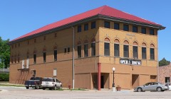 | Anna C. Diller Opera House | building | 1988 | 88000932 |
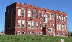 | District No. 1 School of Jefferson County | building | 1997 | 97001520 |
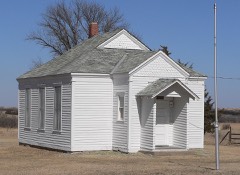 | District No. 10 School | building | 1978 | 78001702 |
| Fairbury Commercial Historic District | district | 1997 | 97000610 | |
| Fairbury Jr/Sr High School and Gymnasium-Auditorium | building | 1999 | 99000391 | |
 | Fairbury Public-Carnegie Library | building | 1985 | 85002141 |
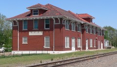 | Fairbury Rock Island Depot and Freight House | building | 1996 | 96000681 |
 | IOOF Temple Building | building | 1987 | 87000925 |
 | Jefferson County Courthouse | building | 1972 | 72000751 |
| John C. Kesterson House | building | 2019 | 100004142 | |
| People's State Bank | building | 1984 | 84000509 | |
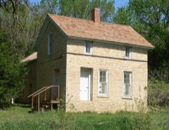 | Woral C. Smith Lime Kiln and Limestone House | building | 1974 | 74001124 |
| Steele City Historic District | district | 1972 | 72000752 |
Every wildfire the federal occurrence database records inside this county: 164 of them, burning about 3,363 acres. 3 started naturally and 2 were recorded as arson. Each settlement page carries the fires within five miles of it.
| Reported cause | Fires |
|---|---|
| Debris and open burning | 104 |
| Equipment and vehicle use | 22 |
| Missing data/not specified/undetermined | 17 |
| Power generation/transmission/distribution | 6 |
| Recreation and ceremony | 4 |
| Natural | 3 |
| Smoking | 3 |
| Railroad operations and maintenance | 2 |
| Arson/incendiarism | 2 |
| Fireworks | 1 |
The five largest, by the area the report gives. None of them was recorded as arson.
| Date | Cause | Size | Reported by | Name on the report |
|---|---|---|---|---|
| 23 March 2016 | Debris and open burning | 700 acres | Nebraska Forest Service | not named |
| 14 March 2015 | Debris and open burning | 450 acres | Nebraska Forest Service | not named |
| 15 March 2015 | Debris and open burning | 401 acres | Nebraska Forest Service | not named |
| 14 March 2009 | Debris and open burning | 200 acres | Nebraska Forest Service | not named |
| 14 March 2018 | Missing data/not specified/undetermined | 136 acres | Nebraska Forest Service | not named |
| 28 February 2020 | Missing data/not specified/undetermined | 120 acres | Nebraska Forest Service | not named |
| 16 March 2015 | Debris and open burning | 120 acres | Nebraska Forest Service | not named |
| 3 November 2020 | Debris and open burning | 100 acres | Nebraska Forest Service | not named |
Every settlement page carries the fires within five miles of it - see the settlement index below.
The NOAA Storm Events Database holds 526 reports for this county, causing 1 death, 3 injuries and about $14,460,010 in recorded property damage. Each settlement page carries the reports that name it.
| Kind of event | Reports |
|---|---|
| Hail | 284 |
| Thunderstorm Wind | 172 |
| Tornado | 26 |
| Flash Flood | 24 |
| Flood | 10 |
| Heavy Rain | 4 |
| Funnel Cloud | 3 |
| Lightning | 3 |
The most serious of them, by death, then injury, then recorded damage. The accounts are quoted exactly as the forecast office filed them.
| When | Event | Place named | Harm | What the report says |
|---|---|---|---|---|
| May 2015 | Flood | Powell | 1 killed, $5,000,000 | Extremely heavy rainfall of 6 to 10 inches fell across the northern basin of the Little Blue River. This cause the river to swell to record levels around the Fairbury area. The flooding resulted in the mandatory evacuations of areas of the western and southern parts of town, to the west of the Union Pacific Railroad tracks. The flooding of some residents along the river did result in one fatality of an elderly residence in her basement. The river crested at 25.42 feet or 6.92 feet above flood stage. |
| April 1956 | Tornado (F3) | not stated | 1 hurt, $250,000 | no account filed |
| May 2014 | Tornado (EF1) | Daykin | 1 hurt | This tornado developed in open country southeast of Daykin and traveled northeast into Saline county with a total track of 15.5 miles (5.8 miles in Jefferson county). |
| June 1984 | Thunderstorm Wind | not stated | 1 hurt | no account filed |
| July 1978 | Tornado (F2) | not stated | $2,500,000 | no account filed |
| May 2008 | Tornado (EF2) | Reynolds | $1,750,000 | This tornado was a continuation of a long-tracked tornado that started in Jewel county Kansas and tracked into Thayer county Nebraska before crossing into Jefferson county Nebraska. The tornado did EF3 damage in Kansas and EF2 damage in Jefferson county. ||In Jefferson county the tornado started 2 miles west and 1 1/4 mile north of Reynolds, knocking over large tree branches, snapping trees and overturning several center pivot irrigation systems. The storm tracked northeast from there continuing to snap wooden power poles and causing additional tree damage as well as farm outbuilding damage. The tornado crossed the Little Blue River 2 3/4 miles northwest of Fairbury before turning east where it attained EF2 strength. There it tore the roof off of a house and destroyed a garage and shed 1 mile west of Highway 15. Heading east from there it hit the Fairbury airport where hangers were damaged. East of the airport, a large barn was destroyed and large trees snapped. The tornado finally lifted about 3 miles east and 3 miles north of Fairbury. From the there the parent thunderstorm continued to produce additional wind damage from eastern Jefferson county into Gage county. In total the tornado caused serious damage to 5 houses in Jefferson county. |
| April 2010 | Tornado (EF1) | Diller | $650,000 | An Assessment team from the NWS determined that a tornado tracked around 3 miles west through northwest of the Diller area. The damage path was around 300 yards at its widest. Trees and farm outbuildings were damaged along its path and 35 large power poles were snapped. A house in the area also sustained major damage to the roof and windows and the upper floor was partially shifted from the lower floor and a wall was bowed outward and garage destroyed. A center irrigation pivot was damaged at the tornadoes lifting point. |
| May 2015 | Flash Flood | Daykin | $500,000 | The emergency manager reported that flash flooding continued as heavy rainfall continued during the overnight. The flooding destroyed a bridge along state highway 15 in northern Jefferson County. |
| June 2001 | Thunderstorm Wind | Reynolds | $500,000 | An area of apparently straight line wind damage was reported from southwest of Fairbury to north of town. Grain bins were destroyed, roofs were damaged, cars thrown, trees were uprooted and power poles were snapped. This was the second slow moving supercell to track across Jefferson county this evening. |
| July 2001 | Thunderstorm Wind | Reynolds | $500,000 | A supercell thunderstorm produced a 20 mile long path of damage due to downburst winds across Jefferson county. The winds were estimated at between 80 and 90 mph. The winds toppled trees and damaged roofs and windows most significantly in a 3 block wide swath in southern Fairbury. Power poles were snapped and several sheds and garages were also destroyed in this area. In rural areas there were center pivot irrigation systems and grain bins overturned as well as scattered tree damage. |
| June 2001 | Thunderstorm Wind | Reynolds | $400,000 | This slow moving supercell earlier produced a tornado in the adjacent county in northern Kansas. In Nebraska, near Reynolds, most of the damage was apparently caused by straight line winds, possibly from the rear flank downdraft, estimated at close to 100 mph. The strong winds stripped corn nearly to the ground in this area, overturned center pivot irrigation systems and grain bins and did some outbuilding damage. The winds also uprooted trees which blocked Highway 8 in town. |
| May 1996 | Tornado (F1) | Harbine | $350,000 | no account filed |
| June 2008 | Flash Flood | Helvey | $250,000 | Heavy rain caused flash flooding that washed out several roads and a bridge near Daykin and also produced runoff from farm fields that flooded across Highway 15 north of Fairbury. Rainfall from the thunderstorms was likely 2 to 4 inches from late afternoon of June 4 into the early morning hours of June 5. |
| May 1996 | Tornado (F1) | Gladstone | $250,000 | no account filed |
| August 1987 | Tornado (F2) | not stated | $250,000 | no account filed |
| April 1976 | Tornado (F1) | not stated | $250,000 | no account filed |
| June 1967 | Tornado (F2) | not stated | $250,000 | no account filed |
| May 2004 | Tornado (F1) | Daykin | $220,000 | See description below |
| April 2012 | Thunderstorm Wind | Daykin | $100,000 | Thunderstorm wind gusts estimated at over 60 mph downed large trees in Daykin which caused some house damage and a welcome sign into town was knocked over. Several center pivots were flipped southwest of town and a private airplane hanger and other tree damage was noted southwest of town as well. |
| May 2007 | Flash Flood | Diller | $75,000 | Rainfall of 4 to 6 inches produced flash flooding across parts of Jefferson county during the early morning hours of May 6th, 2007. One area of flooding was noted along Highway 103 near Diller where water was flowing across the road. At least 1 county road bridge and a number of culverts were washed out in the area. |
| June 2015 | Flash Flood | Fairbury | $50,000 | Emergency management reported multiple roads flooded in the city of Fairbury. |
| May 2001 | Thunderstorm Wind | Diller | $50,000 | Thunderstorm wind gusts uprooted a few trees and downed 2 power poles. Two roofs were also taken off machine sheds, the damage path was about a quarter of a mile wide. |
| April 2001 | Thunderstorm Wind | Endicott | $40,000 | Thunderstorm winds did tree damage and downed power lines around Endicott. Some roofs were also severely damaged. |
| April 2001 | Thunderstorm Wind | Fairbury | $40,000 | Thunderstorm winds blew a roof off of a home near Fairbury. |
| August 2025 | Thunderstorm Wind | Thompson | $29,810 | A severe wind event struck Jefferson County, Nebraska, during the morning of August 10th, 2025, impacting the area along a swath that extended from the southwest to the northeast portion of the county. The limited measured reports indicated gusts up to 65 miles per hour in Plymouth and 62 miles per hour 6 miles west-northwest of Fairbury. However, damage reports suggested pockets of much more intense winds occurred across the county.||The highest estimated wind speed was 95 miles per hour 4 miles west of Endicott, reported by Law Enforcement, which resulted in a power pole down and a corresponding power outage. Further east, an estimated 90 miles per hour gust caused significant damage to a large grain bin 2 miles west-southwest of Plymouth. Given these impacts to public utility and agricultural infrastructure, the damage cost estimated for public infrastructure was $29,813.00. This relatively lower figure indicates that while severe, the core damage was highly localized, and this estimate only covers damage to public assets, not private property losses. |
| July 1978 | Tornado | not stated | $25,000 | no account filed |
| April 1963 | Tornado (F2) | not stated | $25,000 | no account filed |
| May 1959 | Tornado (F1) | not stated | $25,000 | no account filed |
| July 2006 | Thunderstorm Wind | Fairbury | $20,000 | Thunderstorm wind gusts estimated at 60 mph snapped a large tree which crashed onto a roof of a nearby house causing significant damage to the roof and one wall. |
| June 1997 | Thunderstorm Wind | Fairbury | $15,000 | Machine shed destroyed and cattle shed damaged. |
| June 1997 | Thunderstorm Wind | Fairbury | $15,000 | no account filed |
| June 2015 | Flash Flood | Daykin | $10,000 | Water was reported over several rural county roads. |
| May 2015 | Flash Flood | Daykin | $10,000 | Extremely heavy rainfall of 5 to 10 inches occurred across the northern half of Jefferson County. This led to flash flooding across a large part of the northern half of the county with numerous road closures reported. |
| August 2007 | Flood | Plymouth | $10,000 | Heavy rain produced flooding along the Little Blue River in early August 2007. The river at Fairbury reached 19.8 feet around 115 am CDT August 2nd, flood stage is 15 feet. The Little Blue River at Fairbury was above flood stage from around 830 am on August 1st until 645 pm on August 2nd. Although the flooding affected mainly agricultural lowlands, there were at least 10 to 12 spots where the water covered county roads, and Highway 4 was also covered by flood waters for a time. ||Fairbury reported 4 inches of rain from the storm with around 8 inches unofficially reported just west of the county line in the town of Alexandria. |
| May 1995 | Tornado (F0) | Northern Daykin | $10,000 | A tornado did damage to a center pivot west of Alexandria, uprooted trees near Alexandria and did wind damage to a barn and took large tree limbs about three miles east and southeast of Daykin. |
| June 1997 | Flash Flood | Fairbury | $8,000 | Ten homes had basements flooded as the Little Blue river rose out of its banks. |
| July 1997 | Thunderstorm Wind | Fairbury | $8,000 | Thunderstorm winds blew down a metal storage shed. |
| June 2017 | Flash Flood | Daykin | $5,000 | Heavy rain caused roads to be covered with water between Plymouth and Swanton in Northern Jefferson County. |
| May 2007 | Flash Flood | Fairbury | $5,000 | Heavy rainfall of an inch or so in an hour or less produced flash flooding of a few streets in Fairbury. In addition, heavy rain caused flash flooding along portions of Indian Creek near Diller according to Jefferson county Emergency Management. A few county roads were closed due to the flood waters. |
| May 1994 | Hail | Daykin | $5,000 | Hail up to quarter-size damaged roofs and 500 acres of crops. |
| June 1997 | Lightning | Endicott | $4,000 | Lightning struck a storage shed owned by Union Pacific Railroad. |
| July 2008 | Flood | Daykin | $1,000 | Slow moving thunderstorms dropped 2 to 3 inches of rain over a small area of western Jefferson county in a two hour period. The heavy rain caused some field and ditch runoff to flood across a few county roads east of Daykin, forcing the closure of one. The flooding mainly just washed some gravel off the road and briefly covered crops in low areas. |
| August 2000 | Hail | Plymouth | $1,000 | Hail up to 1 inch in diameter nearly covered the ground white from southwest of Plymouth into town. The hail also broke several windows in town. |
| July 2000 | Thunderstorm Wind | Gladstone | $1,000 | A thunderstorm wind gust estimated at over 60 mph destroyed a calf barn by throwing it's roof onto a nearby heifer barn and knocking down it's walls. Fortunately no cattle were injured. |
| May 1995 | Hail | Daykin | $1,000 | no account filed |
| May 2002 | Thunderstorm Wind | Plymouth | $500 | Thunderstorm winds caused a large tree to break in Plymouth causing minor damage to a roof. The winds also broke a window, storm window and screen at the home. |
| May 1993 | Hail | Fairbury | $500 | Golf ball-size hail caused minor damage. Damage included breaking the windshield of a truck. |
| May 1996 | Thunderstorm Wind | Fairbury | $200 | no account filed |
| March 2026 | Hail | Steele City | - | Emergency management report of hail measured at 1.50 inch in diameter. Photo of several 1.25 to 1.5 inch diameter stones. |
| March 2026 | Hail | Plymouth | - | Public report of hail estimated at 1.00 inch in diameter. |
| March 2026 | Hail | Plymouth | - | Public report of hail measured at 2.00 inch in diameter. |
| March 2026 | Hail | Plymouth | - | Public report of hail measured at 1.00 inch in diameter. |
| March 2026 | Hail | Shea | - | Emergency management report of hail measured at 1.25 inch in diameter. |
| April 2026 | Hail | Fairbury | - | Emergency management report of hail estimated up to 1 inch in diameter in Fairbury, NE. |
| April 2026 | Hail | Fairbury | - | Public report relayed by emergency management of hail estimated up to 1.75 inches in diameter in Fairbury, NE. |
| April 2026 | Hail | Fairbury | - | Public report of hail estimated up to 1 inch in diameter in Fairbury, NE. |
| April 2026 | Hail | Fairbury | - | Public report of hail measured up to 1.75 inches in diameter near Fairbury, NE. |
| April 2026 | Hail | Fairbury | - | Public report of hail measured up to 2 inches in diameter near Fairbury, NE. |
| March 2025 | Thunderstorm Wind | Plymouth | - | Public report on social media of a measured 66 mph wind gust. |
| March 2025 | Thunderstorm Wind | Fairbury | - | Emergency manager report of a measured 70 mph wind gust. |
The Survey's mineral resources record lists 1 working inside this county. It still produces. Each settlement page carries the workings within five miles of it.
| Commodity | Workings |
|---|---|
| Clay | 1 |
The least common of them first, because a county's hundredth gravel pit says nothing its first ten did not.
| Where | Site | Commodity | Status | Recorded |
|---|---|---|---|---|
| Endicott Pit & Plant | Clay | Producer |
Named settlements recorded in the Geographic Names Information System, each with the topographic sheets covering it. Villages, hamlets and abandoned places alike. Each is shown with the nearest named watercourse or landform and the survey quadrangle it falls on.
Richland precinct · 68352 · Western SW quadrangle
10 sheets, 1955 to 1985
No longer a settlement
Meridian precinct · 68303 · Gladstone quadrangle
10 sheets, 1955 to 1985
No longer a settlement
Meridian precinct · 68352 · On Big Sandy Creek · Gladstone quadrangle
10 sheets, 1955 to 1985
Endicott precinct · 68440 · Near Steele City Canyon · Endicott quadrangle
10 sheets, 1955 to 1985
The vanished settlements of Jefferson County: the places named above that are no longer on the map.