 Block
From the record
5 National Register listings published here.
Sources: the National Register database, National Park Service
12 topographic sheets cover 7 settlements here, and 5 properties are on the National Register of Historic Places.
5 National Register listings published here.
Sources: the National Register database, National Park Service
Every property in this county listed on the National Register of Historic Places, with the year it was listed and the federal nomination document.
| Photograph | Property | Type | Listed | Reference |
|---|---|---|---|---|
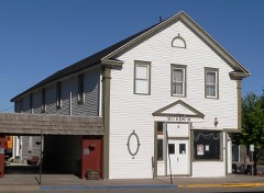 | Fraternal Hall | building | 1983 | 83001096 |
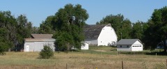 | Gridley-Howe-Faden-Atkins Farmstead | building | 1997 | 97000727 |
 | Kimball County Courthouse | building | 1990 | 90000973 |
 | Maginnis Irrigation Aqueduct | structure | 1994 | 94001231 |
 | Wheat Growers Hotel | building | 2002 | 02000769 |
Every wildfire the federal occurrence database records inside this county: 74 of them, burning about 3,843 acres. 13 started naturally and 1 was recorded as arson. Each settlement page carries the fires within five miles of it.
| Reported cause | Fires |
|---|---|
| Equipment and vehicle use | 24 |
| Natural | 13 |
| Missing data/not specified/undetermined | 11 |
| Debris and open burning | 10 |
| Railroad operations and maintenance | 8 |
| Power generation/transmission/distribution | 2 |
| Recreation and ceremony | 2 |
| Smoking | 2 |
| Arson/incendiarism | 1 |
| Fireworks | 1 |
The five largest, by the area the report gives. None of them was recorded as arson.
| Date | Cause | Size | Reported by | Name on the report |
|---|---|---|---|---|
| 17 August 2019 | Natural | 1,400 acres | Nebraska Forest Service | not named |
| 26 April 2012 | Equipment and vehicle use | 560 acres | Nebraska Forest Service | not named |
| 12 July 2020 | Natural | 400 acres | Nebraska Forest Service | not named |
| 5 November 2020 | Equipment and vehicle use | 300 acres | Nebraska Forest Service | not named |
| 30 July 2017 | Equipment and vehicle use | 200 acres | Nebraska Forest Service | not named |
| 21 January 2002 | Power generation/transmission/distribution | 150 acres | Nebraska Forest Service | not named |
| 4 August 2017 | Natural | 100 acres | Nebraska Forest Service | not named |
| 11 July 2016 | Natural | 80 acres | Nebraska Forest Service | not named |
Every settlement page carries the fires within five miles of it - see the settlement index below.
The NOAA Storm Events Database holds 426 reports for this county, causing 2 deaths, 2 injuries and about $7,427,560 in recorded property damage. Each settlement page carries the reports that name it.
| Kind of event | Reports |
|---|---|
| Hail | 260 |
| Tornado | 61 |
| Thunderstorm Wind | 59 |
| Flash Flood | 29 |
| Heavy Rain | 6 |
| Funnel Cloud | 5 |
| Flood | 4 |
| Winter Weather | 1 |
| Wildfire | 1 |
The most serious of them, by death, then injury, then recorded damage. The accounts are quoted exactly as the forecast office filed them.
| When | Event | Place named | Harm | What the report says |
|---|---|---|---|---|
| December 1997 | Winter Weather | Countywide | 2 killed, 1 hurt, $40,000 | no account filed |
| May 2000 | Hail | Kimball | 1 hurt, $5,000,000 | Large hail damaged much of Kimball, NE, with 40 to 50 percent of the city reporting excessive damage. |
| May 1997 | Flash Flood | Bushnell | $1,000,000 | A series of thunderstorms produced in excess of 7.5 inches of rain over parts of western Kimball County during a 5-hour time frame. Flooding occurred along Lodgepole Creek from Bushnell east to the county line. |
| June 1997 | Hail | Kimball | $1,000,000 | 6000 acres of crops damaged: several roads damaged. |
| June 2004 | Thunderstorm Wind | Kimball | $45,000 | Microburst wind gusts damaged trailers in mobile home park. |
| June 1997 | Hail | Kimball | $30,000 | no account filed |
| August 2004 | Thunderstorm Wind | Kimball | $25,000 | Wind gusts estimated from 70-80 mph blew down approximately 40 feet of a 120 foot smokestack at a waste management facility. |
| June 1977 | Tornado (F2) | not stated | $25,000 | no account filed |
| July 1966 | Tornado (F0) | not stated | $25,000 | no account filed |
| June 1960 | Tornado (F3) | not stated | $25,000 | no account filed |
| June 1954 | Tornado (F2) | not stated | $25,000 | no account filed |
| August 1996 | Hail | Dix | $20,000 | no account filed |
| July 1998 | Flash Flood | Kimball | $15,000 | Thunderstorms produced rainfall amounts of 3 to 6 inches around the Kimball area. Flood waters covered roads from 2 miles north of Kimball to 1 mile south of Dix. The flood waters also damaged or destroyed bean, wheat and corn crops around the area. |
| July 1998 | Flash Flood | Kimball | $15,000 | Thunderstorms produced up to 2 inches of rain in the Kimball area, resulting in the shutting down of the underpass of Highway 71 and the Union Pacific tracks. A few local businesses received damage as well. |
| June 1997 | Hail | Dix | $15,000 | no account filed |
| June 1997 | Hail | Kimball | $15,000 | no account filed |
| June 2010 | Flash Flood | Bushnell | $10,000 | County roads washed out from heavy rainfall just south of town. |
| July 2010 | Thunderstorm Wind | Kimball | $10,000 | Estimated 55-60 MPH gusts caused three power poles to be blown over. 1.50 inches of heavy rain also fell over a short time span. |
| July 2009 | Thunderstorm Wind | Kimball | $10,000 | Sudden wind gust blew over a tractor-trailer on Interstate 80 near Kimball, Ne. |
| May 1997 | Hail | Kimball | $10,000 | Ping Pong ball sized hail fell in southwest Kimball County. |
| May 1997 | Hail | Kimball | $10,000 | A second storm dumped Ping Pong ball sized hail and very heavy rain within 2 miles of the location that received 1.5 inch hail an hour earlier. |
| June 1997 | Hail | Dix | $10,000 | no account filed |
| June 1997 | Hail | Kimball | $10,000 | no account filed |
| July 1998 | Hail | Kimball | $7,000 | A thunderstorm produced golfball size hail, 5 miles north of Kimball. |
| June 2009 | Flash Flood | Dix | $5,000 | Public reported that Sidney Draw was flowing out of its banks 8 feet deep and 1/4 mile wide, and flowing over county road 8. |
| July 1998 | Hail | Kimball | $4,000 | A storm produced golfball size hail 25 miles northwest of Kimball. |
| July 1998 | Thunderstorm Wind | Dix | $3,000 | A storm produced a wind gust of 80 mph 9 miles north of Dix, which damaged a roof of a home. |
| August 1997 | Tornado (F0) | Dix | $3,000 | Unconfirmed public report; farm building damaged. |
| August 1978 | Tornado | not stated | $2,500 | no account filed |
| May 1976 | Tornado (F0) | not stated | $2,500 | no account filed |
| May 2010 | Flash Flood | Bushnell | $2,000 | Two draws that flowed into Lodgepole Creek were flooded and flowing rapidly. Some damage to the banks of Interstate 80 near the Wyoming and Nebraska state line showed a lot of erosion. |
| May 2010 | Hail | Kimball | $2,000 | Restaurant windows broken. Report relayed from VORTEX Team. |
| July 1998 | Flood | Countywide | $2,000 | Stationary thunderstorms produced up to 2.5 inches of rain across Kimball County. Water was flowing over roads in northern Kimball County. |
| August 1997 | Hail | Kimball | $2,000 | no account filed |
| June 1997 | Hail | Kimball | $2,000 | no account filed |
| July 1988 | Tornado (F0) | not stated | $250 | no account filed |
| May 1977 | Tornado | not stated | $250 | no account filed |
| July 1986 | Tornado (F0) | not stated | $30 | no account filed |
| June 1979 | Tornado (F0) | not stated | $30 | no account filed |
| March 2025 | Hail | Bushnell | - | A trained spotter just east of Pine Bluffs and the Nebraska and Wyoming border reported 1 inch diameter hail along Interstate 80. |
| March 2025 | Hail | Dix | - | A trained spotter north of Kimball Nebraska reported 1.25 inch diameter hail. |
| March 2025 | Hail | Kimball | - | Trained Spotter north of Kimball Nebraska reported a maximum hail stone size of 1.50 inches in diameter. |
| March 2025 | Thunderstorm Wind | Dix | - | Union Pacific Railroad site near Dix Nebraska reported a maximum wind gust of 60 mph with a severe thunderstorm. |
| June 2025 | Hail | Dix | - | Storm Chaser reporting ping pong ball sized hail in Dix. |
| May 2025 | Thunderstorm Wind | Kimball | - | Thunderstorm wind gust of 63mph reported 3 WNW Brownson. |
| May 2025 | Thunderstorm Wind | Kimball | - | AWOS site in Kimball reported a 70mph wind gust. |
| September 2025 | Hail | Oliver | - | Five miles west of Kimball. Storm Chaser submitted photo of 1.75 inch hail via social media. |
| September 2025 | Hail | (Ibm)Kimball Arpt | - | Storm Chaser reported quarter sized hail near Dix, Nebraska. |
| June 2025 | Tornado (EF0) | Bushnell | - | Brief tornado touched down in a field, verified by photos and timing estimated with radar. Damage to a center pivot irrigation system. |
| June 2025 | Hail | Bushnell | - | Trained spotter reports ping pong ball size hail southwest of Kimball Nebraska. |
| June 2025 | Hail | Bushnell | - | Public reports quarter size hail. |
| June 2025 | Hail | Kimball | - | Public reports quarter size hail. |
| August 2024 | Thunderstorm Wind | Kimball | - | Kimball Airport AWOS station (KIBM) measured wind gust. |
| August 2024 | Thunderstorm Wind | Bushnell | - | AWOS station K1EW located 6 miles southeast of Pine Bluffs Wyoming reported this wind gust. |
| August 2024 | Hail | Bushnell | - | Trained storm spotter reported golf ball sized hail at this location. Delayed report, so time estimated from radar. |
| May 2023 | Thunderstorm Wind | Dix | - | Mesonet station UP261 measured maximum wind gust 1 miles east of Dix. |
| May 2023 | Tornado (EFU) | Bushnell | - | Trained weather spotters observed a brief tornado approximately 3 miles NW of Bushnell. |
| May 2023 | Hail | Bushnell | - | An Emergency Management Official reported quarter sized hail approximately 3 miles south of Bushnell. |
| June 2023 | Hail | Dix | - | Baseball sized hail was observed 12 miles SE of Kimball by local Emergency Management officials. |
| June 2023 | Hail | Dix | - | Three-inch diameter hail was reported 4 miles S of Dix. |
Named settlements recorded in the Geographic Names Information System, each with the topographic sheets covering it. Villages, hamlets and abandoned places alike. Each is shown with the nearest named watercourse or landform and the survey quadrangle it falls on.