 Block
From the record
One of 5 National Register listings published here for Kimball County · listed in 1990 · category: Building.
Sources: the case file at the National Archives · the National Register database, National Park Service

Listed on the National Register of Historic Places in 1990.
One of 5 National Register listings published here for Kimball County · listed in 1990 · category: Building.
Sources: the case file at the National Archives · the National Register database, National Park Service
Regional context, not property-specific evidence. The federal wildfire occurrence database lists 2 fires within 5 miles of Kimball County Courthouse between 2002 and 2004, burning about 150 acres in total. None started naturally. None was recorded as arson. Distance is straight-line from the map coordinates, so a fire counted here may appear on a neighbouring settlement's page as well.
| Reported cause | Fires |
|---|---|
| Equipment and vehicle use | 1 |
| Power generation/transmission/distribution | 1 |
The most recent of them, most recent first, with the day each was reported and the service that recorded it.
| Date | Cause | Size | Reported by | Name on the report |
|---|---|---|---|---|
| 21 January 2002 | Power generation/transmission/distribution | 150 acres | Nebraska Forest Service | not named |
| 1 January 2004 | Equipment and vehicle use | under an acre | Nebraska Forest Service | not named |
Regional context, not property-specific evidence. The National Weather Service names Kimball, the town this property stands in, in 164 storm reports between 1993 and 2025: 98 hail, 21 thunderstorm wind, 20 tornado, 14 flash flood. The reports record 1 injury. Each account below is quoted exactly as the forecast office filed it, from the NOAA Storm Events Database, and each date opens the federal record of that event.
| When | Event | Place named | Harm | What the report says |
|---|---|---|---|---|
| May 2000 | Hail | Kimball | 1 hurt, $5,000,000 | Large hail damaged much of Kimball, NE, with 40 to 50 percent of the city reporting excessive damage. |
| June 1997 | Hail | Kimball | $1,000,000 | 6000 acres of crops damaged: several roads damaged. |
| June 2004 | Thunderstorm Wind | Kimball | $45,000 | Microburst wind gusts damaged trailers in mobile home park. |
| June 1997 | Hail | Kimball | $30,000 | no account filed |
| August 2004 | Thunderstorm Wind | Kimball | $25,000 | Wind gusts estimated from 70-80 mph blew down approximately 40 feet of a 120 foot smokestack at a waste management facility. |
| July 1998 | Flash Flood | Kimball | $15,000 | Thunderstorms produced rainfall amounts of 3 to 6 inches around the Kimball area. Flood waters covered roads from 2 miles north of Kimball to 1 mile south of Dix. The flood waters also damaged or destroyed bean, wheat and corn crops around the area. |
| July 1998 | Flash Flood | Kimball | $15,000 | Thunderstorms produced up to 2 inches of rain in the Kimball area, resulting in the shutting down of the underpass of Highway 71 and the Union Pacific tracks. A few local businesses received damage as well. |
| June 1997 | Hail | Kimball | $15,000 | no account filed |
| July 2010 | Thunderstorm Wind | Kimball | $10,000 | Estimated 55-60 MPH gusts caused three power poles to be blown over. 1.50 inches of heavy rain also fell over a short time span. |
| July 2009 | Thunderstorm Wind | Kimball | $10,000 | Sudden wind gust blew over a tractor-trailer on Interstate 80 near Kimball, Ne. |
| May 1997 | Hail | Kimball | $10,000 | Ping Pong ball sized hail fell in southwest Kimball County. |
| May 1997 | Hail | Kimball | $10,000 | A second storm dumped Ping Pong ball sized hail and very heavy rain within 2 miles of the location that received 1.5 inch hail an hour earlier. |
| June 1997 | Hail | Kimball | $10,000 | no account filed |
| July 1998 | Hail | Kimball | $7,000 | A thunderstorm produced golfball size hail, 5 miles north of Kimball. |
| July 1998 | Hail | Kimball | $4,000 | A storm produced golfball size hail 25 miles northwest of Kimball. |
| May 2010 | Hail | Kimball | $2,000 | Restaurant windows broken. Report relayed from VORTEX Team. |
| August 1997 | Hail | Kimball | $2,000 | no account filed |
| June 1997 | Hail | Kimball | $2,000 | no account filed |
| March 2025 | Hail | Kimball | - | Trained Spotter north of Kimball Nebraska reported a maximum hail stone size of 1.50 inches in diameter. |
| May 2025 | Thunderstorm Wind | Kimball | - | Thunderstorm wind gust of 63mph reported 3 WNW Brownson. |
| May 2025 | Thunderstorm Wind | Kimball | - | AWOS site in Kimball reported a 70mph wind gust. |
| June 2025 | Hail | Kimball | - | Public reports quarter size hail. |
| August 2024 | Thunderstorm Wind | Kimball | - | Kimball Airport AWOS station (KIBM) measured wind gust. |
| July 2023 | Hail | Kimball | - | Public report of 1 inch hail north of Kimball. |
| June 2023 | Hail | Kimball | - | A storm chaser reported ping-pong ball sized hail 1 mile S of Kimball. |
| June 2023 | Hail | Kimball | - | Golf ball sized hail was reported in the city of Kimball. |
| June 2023 | Hail | Kimball | - | Ping-pong ball sized hail was reported 1 mile S of Kimball by a trained spotter. |
| June 2023 | Hail | Kimball | - | An Emergency Manager reported tennis ball sized hail 3 miles SE of Kimball. |
| August 2022 | Flash Flood | Kimball | - | Significant runoff and street flooding observed near Kimball. Kimball Airport AWOS station (KIBM) measured 1.26 inches of rainfall in less than 90 minutes. |
| June 2019 | Tornado (EFU) | Kimball | - | Observer reported brief landspout tornado just east of Highway 71 south of the Banner and Kimball County line. Landspout remained over open fields leaving no discernible damage to apply any rating other than unknown. |
| May 2018 | Hail | Kimball | - | Quarter size hail was observed northeast of Kimball. |
| September 2018 | Hail | Kimball | - | Dime to quarter size hail covered the ground. |
| July 2018 | Hail | Kimball | - | Baseball size hail was observed at the landfill. |
| July 2018 | Flash Flood | Kimball | - | More than two inches of rain in an hour produced flash flooding in Kimball. Several streets and underpasses were inundated by more than a foot of water. |
| July 2018 | Hail | Kimball | - | Quarter size hail was observed south of Kimball. |
| May 2017 | Hail | Kimball | - | Quarter size hail was observed 10 miles west of Kimball. |
| June 2017 | Hail | Kimball | - | Quarter size hail was observed five miles west of Kimball. |
| September 2017 | Hail | Kimball | - | Half dollar size hail was observed at Kimball. |
| June 2016 | Heavy Rain | Kimball | - | Two to three inches of rain fell in less than two hours in and around Kimball. |
| September 2016 | Hail | Kimball | - | Golf ball size hail was reported at Kimball. |
| September 2016 | Hail | Kimball | - | Golf ball size hail was reported five miles northeast of Kimball. |
| September 2016 | Hail | Kimball | - | Quarter size hail was reported 20 miles northeast of Kimball. |
| June 2016 | Thunderstorm Wind | Kimball | - | Downburst wind gusts were estimated as high as 90 mph. There was extensive damage to trees and power poles, with power outages reported. Two buildings were damaged north of Kimball at Highway 71. |
| July 2016 | Hail | Kimball | - | Hen egg size hail was reported on Highway 71 three miles south of Kimball. |
| July 2016 | Hail | Kimball | - | Half dollar to ping pong ball size hail was reported eight miles northwest of Kimball. |
| August 2015 | Thunderstorm Wind | Kimball | - | Microburst winds estimated between 65 and 70 mph snapped six inch limbs and blew a 25 x 25 foot metal shed on top of a Kimball motel. |
| August 2015 | Flash Flood | Kimball | - | Five to eight inches of rain overnight over east central Kimball County produced flash flooding. County Road 45 near US Highway 30 was washed out. County Road 55 near US Highway 30 and railroad was washed out. Extensive lowland flooding was reported along the Lodgepole Creek drainage basin as well as areas surrounding Interstate 80 from three miles east of Kimball to two miles west of Dix. |
| May 2014 | Flash Flood | Kimball | - | Flash flooding was observed along Lodgepole Creek between Kimball and Dix. Water was running over the County Road 47 and 49 bridges. |
| May 2014 | Hail | Kimball | - | Penny to quarter size hail was observed south of Kimball. |
| May 2014 | Thunderstorm Wind | Kimball | - | Winds were estimated from 60 to 65 mph east of Kimball. |
| March 2014 | Flood | Kimball | - | Emergency management officials reported excessive runoff flowed into Lake Oliver. Highway 30 and County Road 37 were closed due to high water one to three miles west of Kimball. |
| June 2014 | Flash Flood | Kimball | - | Excessive runoff from two to three inches of rain caused flash flooding, with Highway 71 closed due to standing water from Kimball to five miles north of Kimball. Other closures included US Highway 30 one mile east of Kimball and Highway 42 four miles north of Kimball. |
| July 2014 | Hail | Kimball | - | Quarter size hail was reported southeast of Kimball. |
| September 2014 | Heavy Rain | Kimball | - | Two and one-tenth inches of rain was reported. |
| July 2014 | Tornado (EF0) | Kimball | - | A weak tornado briefly touched down in an open area south of Kimball. |
| July 2014 | Thunderstorm Wind | Kimball | - | Wind gusts were estimated from 60 to 70 mph southwest of Kimball. The strong winds downed power lines. |
| July 2013 | Hail | Kimball | - | Golf ball size hail was reported north of Kimball. |
| August 2013 | Thunderstorm Wind | Kimball | - | A wind gust of 62 mph was reported west of Kimball. |
| May 2013 | Tornado (EF0) | Kimball | - | A weak tornado touched down in open country northwest of Kimball. The tornado moved northeast and was in contact with ground for 10 minutes before it lifted just west of State Highway 71 north of Kimball. No damage was reported. |
| June 2013 | Flash Flood | Kimball | - | More than three inches of rain in less than three hours caused flash flooding along Highway 71 between the Banner-Kimball County line and County Road 48. Up to six inches of water flowed across this three-mile stretch of highway. |
No historic map-sheet match is published for this property yet. That does not mean no map exists. This record needs a coordinate-quality review before it can be joined to a sheet boundary. Browse the county's mapped places while that work is pending.
Other National Register properties close enough to walk or drive between, ordered by distance from this one. Both positions come from the same geocoding pass that matched these properties to their map sheets.
| Photograph | Property | Distance | Listed |
|---|---|---|---|
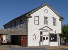 | Fraternal Hall | 0.1 miles | 1983 |
 | Wheat Growers Hotel | 0.2 miles | 2002 |
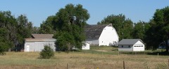 | Gridley-Howe-Faden-Atkins Farmstead | 0.8 miles | 1997 |
 | Maginnis Irrigation Aqueduct | 6.1 miles | 1994 |
| National Archives record | The nomination case file for reference 90000973 in Record Group 79. |
| Kimball County | All 5 listed properties in this county. |