 Block
From the record
14 National Register listings published here, 1 of them a National Historic Landmark.
Sources: the county history on the Internet Archive · the National Register database, National Park Service
39 topographic sheets cover 12 settlements here, and 14 properties are on the National Register of Historic Places.
14 National Register listings published here, 1 of them a National Historic Landmark.
Sources: the county history on the Internet Archive · the National Register database, National Park Service
Every property in this county listed on the National Register of Historic Places, with the year it was listed and the federal nomination document.
| Photograph | Property | Type | Listed | Reference |
|---|---|---|---|---|
 | Bertrand Site | site | 1969 | 69000138 |
 | Blair High School | building | 1991 | 91000300 |
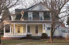 | Abraham Castetter House | building | 1982 | 82003203 |
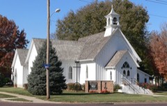 | Congregational Church of Blair | building | 1979 | 79001457 |
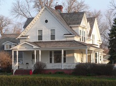 | C. C. Crowell Jr. House | building | 1982 | 82003204 |
| Dana College Campus | district | 2021 | 100006792 | |
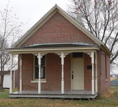 | Fontanelle Township Hall | building | 1982 | 82003205 |
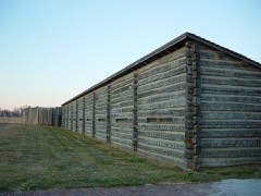 | Fort Atkinson | site | 1966 | 66000454 |
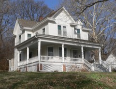 | Alfred H. and Sarah Frahm House | building | 2006 | 06000101 |
 | Gottsch Farmstead | building | 2016 | 16000516 |
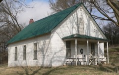 | Long Creek School | building | 2001 | 01000167 |
 | George A. Marshall House | building | 2018 | 100003096 |
| Trinity Seminary Building | building | 1980 | 80004528 | |
 | Washington County Courthouse | district | 1990 | 89002221 |
Every wildfire the federal occurrence database records inside this county: 72 of them, burning about 664 acres. 3 started naturally and 1 was recorded as arson. Each settlement page carries the fires within five miles of it.
| Reported cause | Fires |
|---|---|
| Debris and open burning | 45 |
| Missing data/not specified/undetermined | 11 |
| Equipment and vehicle use | 7 |
| Natural | 3 |
| Recreation and ceremony | 2 |
| Smoking | 2 |
| Arson/incendiarism | 1 |
| Railroad operations and maintenance | 1 |
The five largest, by the area the report gives. None of them was recorded as arson.
| Date | Cause | Size | Reported by | Name on the report |
|---|---|---|---|---|
| 5 April 2014 | Debris and open burning | 140 acres | Nebraska Forest Service | not named |
| 22 April 2014 | Debris and open burning | 80 acres | Nebraska Forest Service | not named |
| 25 April 2014 | Debris and open burning | 80 acres | Nebraska Forest Service | not named |
| 15 March 2014 | Debris and open burning | 50 acres | Nebraska Forest Service | not named |
| 28 December 2003 | Missing data/not specified/undetermined | 47 acres | Boyer Chute National Wildlife Refuge | SOUTH CHUTE |
| 30 April 2001 | Recreation and ceremony | 45 acres | Boyer Chute National Wildlife Refuge | SIGNAL |
| 26 April 2014 | Debris and open burning | 40 acres | Nebraska Forest Service | not named |
| 6 March 2015 | Equipment and vehicle use | 20 acres | Nebraska Forest Service | not named |
Every settlement page carries the fires within five miles of it - see the settlement index below.
The NOAA Storm Events Database holds 356 reports for this county, causing no deaths, 8 injuries and about $28,205,000 in recorded property damage. Each settlement page carries the reports that name it.
| Kind of event | Reports |
|---|---|
| Hail | 162 |
| Thunderstorm Wind | 137 |
| Tornado | 23 |
| Flood | 16 |
| Flash Flood | 12 |
| Funnel Cloud | 3 |
| Lightning | 2 |
| Heavy Rain | 1 |
The most serious of them, by death, then injury, then recorded damage. The accounts are quoted exactly as the forecast office filed them.
| When | Event | Place named | Harm | What the report says |
|---|---|---|---|---|
| October 2002 | Thunderstorm Wind | Ft Calhoun | 3 hurt, $3,000,000 | Thunderstorm downburst winds produced a 5 to 6 mile wide path of damage from around 5 miles southwest of Ft. Calhoun into the Ft. Calhoun area. The wind damage was from the same storm complex that produced the damage in northwest Douglas county. Winds with this damage path were estimated by the NWS to be stronger than those observed in Douglas county, perhaps around 100 mph. The winds caused extensive tree damage and also destroyed a house just northwest of Ft. Calhoun causing 2 minor injuries. Windows were reported to be blown out by the winds and wind driven hail also caused substantial window, roof and siding damage with an estimated 85 percent of all homes in town damaged to some degree. One woman required emergency room treatment after being caught out in the open and pelted with hail up to quarter size. The storm caused an estimated 3 million dollars worth of damage. |
| August 2025 | Thunderstorm Wind | Washington | 2 hurt, $2,700,000 | A damaging wind event swept across Washington County, Nebraska, during the morning hours of August 9th, 2025, with a path of damage extending from the southwest to the eastern portion of the county. Measured wind reports indicated damaging wind speeds, with a maximum measured gust of 86 miles per hour reported by a public station 1 mile south-southeast of Blair. Widespread measured gusts throughout the county ranged from 58 miles per hour (recorded at the Blair Municipal AWOS) to 70 miles per hour.||However, the severity of the damage suggested straight-line winds were considerably higher, with the peak estimated wind speed reaching 110 miles per hour 1 mile south-southeast of Blair, where a building roof collapse was reported. Near Blair, the destruction was particularly acute; estimated 95 miles per hour gusts snapped large tree trunks, and estimated 90 miles per hour winds resulted in a very large tree fell onto a camper 4 miles northeast of Blair. Other reports of estimated 90 mph gusts included siding ripped off a garage and large trees (2-3 feet in diameter) downed near 2 SSE Kennard. Given the wide-scale damage to infrastructure, the estimated cost for public infrastructure repairs alone reached $2,699,403.00. This figure does not reflect the total economic damage, which includes the extensive losses sustained by private and commercial properties. |
| April 2001 | Tornado (F1) | Arlington | 1 hurt, $600,000 | A tornado touched down 4 1/2 miles north northeast of Arlington and moved north northeast for approximately 5 miles before lifting 1 mile east of county road 15 on county road 16. The tornado damaged 6 farmsteads including farm homes and barns and leveled 3 outbuildings west of Blair as well as downing power lines and damaging trees. One man was injured slightly when a 2 by 4 flew through a window hitting him on the chest and cutting him with flying glass. |
| June 1953 | Tornado (F2) | not stated | 1 hurt, $25,000 | no account filed |
| April 2024 | Tornado (EF4) | Washington | 1 hurt | This segment of the tornado is a continuation of the EF-4 tornado that tracked through western Douglas County. After crossing Dutch Hall road into southern Washington County, the tornado damaged homes and farm outbuildings between County Road 29 and County Road 31 from Dutch Hall Road to County Road 36. The width of the tornado at this time ranged from one-third to one-half mile wide. The most significant damage was sustained to a home, machine shop and horse barn, one-third of a mile southeast of the intersection of County Road 40 and County Road 29. Trees were snapped and debarked, the house was moved from its foundation, flat-bed and horse-trailers rolled or lofted, and the machine shop and horse barns destroyed. The storm damage survey following this tornado determined high-end EF-3 damage occurred here. At least one horse was killed, and several others were injured. After this, the tornado crossed the intersection of County Road 36 and County Road 31, producing EF-0 to EF-1 damage in the form of partial roof and siding loss to farm buildings and manufactured homes, plus the snapping of large tree limbs. As it approached State Highway 133, several homes and farm outbuildings sustained EF-2 damage due to the loss of roofs or exterior walls. Crossing Highway 133, the tornado was just less than one-half mile wide, and moved into residential areas generally between County Road 32 and US Highway 75. The most significant damage of the whole tornado track occurred near the intersections of County Road P30 and County Road 33 with the destruction of multiple homes. Several houses were rated with high-end EF-3 damage, and one house was rated as receiving EF-4 damage. Peak winds in this area were estimated to be 170 miles per hour. The tornado then crossed US Highway 75 about 2 miles southeast of Blair moving across the very southern portion of the Cargill plant. The tornado weakened and narrowed, but snapped power poles and derailed several empty rail container cars from the tracks, resulting in EF-1 damage. The peak width of the tornado during this segment of its track was 1900 yards wide, with an average width of around 1000 yards. The tornado continued into southwestern Harrison county in Iowa where it dissipated shortly after crossing US Highway 30. |
| May 2004 | Hail | Blair | $10,000,000 | Hail up to baseball size fell in Blair and west through south of town. The hail caused extensive damage to cars and at least two large car dealerships were hit with over 4500 cars damaged. Houses and trees in town were also damaged and Dana College sustained 1 million dollars in damage in broken windows, skylights and vents. Two hundred windows were broken on campus. The dollar damage total was from eastern Dodge county into Washington county, with over half of it likely in Washington county around and in the Blair area. |
| August 1999 | Flash Flood | Arlington | $4,000,000 | Very heavy rain, Blair received 8 inches, fell over much of Washington county from Friday afternoon into early Saturday morning 8/7/99. Street flooding was reported in Arlington, Blair and Herman, especially along Bell Creek. A 20 foot deep gorge was carved out along highway 75 north of Fort Calhoun. Highway 30 in Arlington was flooded and highway 75 south of Blair was closed until 1100 am cst 8/7/99 due to flood waters. The flooding caused around 4 million dollars in damage mainly due to flooded basements and vehicles and washed out roads and bridges. |
| August 1990 | Tornado (F1) | not stated | $2,500,000 | no account filed |
| August 1977 | Tornado | not stated | $2,500,000 | no account filed |
| June 2011 | Flood | Blair Arpt | $550,000 | Flooding along the Missouri River gradually worsened during June as record releases from Gavins Point Dam brought widespread flooding along the river. The river near Blair climbed to around its 26.5 foot flood stage late in May, and then steadily rose into mid to late June climbing to a little over 32 feet during the last week or so of the month. The flooding in Washington county was especially felt in the Fort Calhoun area where at least 60 homes or cabins were flooded or cutoff by flood waters. At least 200 residences in the county were evacuated leaving at least 500 people displaced. This prompted the city to open the high school up for flood victims. Blair spent $500,000 to build up a levee surrounding its water treatment plant which held through June. The Ft. Calhoun Nuclear power plant was in refueling shut-down when the flooding started in April and because of the high waters it remained shut down through the summer as flood waters surrounded the plant prompting emergency sand-bagging. In addition, recreation areas and roads along the river were flooded. A 58 year-old male drowned when working on a levee near Ft. Calhoun when his truck overturned into flood waters. The flooding persisted into July. |
| July 2011 | Flood | Blair Arpt | $500,000 | Flooding along the Missouri River gradually worsened during June and continued through July as record releases from Gavins Point Dam brought widespread flooding along the River. The river near Blair climbed to around its 26.5 foot flood stage late in May, and then steadily rose in June reaching a little over 32 feet during the last week or so of the month. The river fell slightly during July but remained in the moderate category into August. The flooding in Washington county was especially felt in the Fort Calhoun area where at least 60 homes or cabins were flooded or cutoff by flood waters. At least 200 residences in the county were evacuated leaving at least 500 people displaced. This prompted the city to open the high school up for flood victims. Blair spent $500,000 to build up a levee surrounding its water treatment plant which held through June. The Ft. Calhoun Nuclear power plant was in refueling shut-down when the flooding started in April and because of the high waters remained shut down through the summer as flood waters surrounded the plant prompting emergency sand bagging. In addition, recreation areas and roads along the river were flooded. The flooding persisted into August. |
| June 1996 | Tornado (F1) | Arlington | $300,000 | no account filed |
| June 2010 | Flood | Arlington | $250,000 | Rainfall of 3 to 5 inches fell across much of the Elkhorn River basin in the week ending June 12th. This caused extensive flooding along the Elkhorn River and many of its tributaries, which was prolonged by additional heavy rain after June 12th. Flooding along the Elkhorn in Washington county closed Highway 30 near Arlington for several days as well as many county roads in the area. Farmland near the river also sustained flood damage. Emergency management stated that there was $100,000 in damage alone to public roads in Washington and Dodge counties. |
| August 1990 | Tornado (F0) | not stated | $250,000 | no account filed |
| July 1998 | Flash Flood | Countywide | $240,000 | no account filed |
| April 1998 | Thunderstorm Wind | Washington | $150,000 | no account filed |
| September 2011 | Flood | Blair Arpt | $100,000 | Flooding along the Missouri River which worsened across Washington county in June and July started improving in late August and the river near Blair finally dropped below its 26.5 foot flood stage in the morning of Sept. 13th. The river near Blair reached a crest of a little over 32 feet during the last week or so of June. In Washington county the flooding especially hit the Fort Calhoun area hard where at least 60 homes or cabins were flooded or cutoff by flood waters. At least 200 residences in the county were evacuated leaving at least 500 people displaced. This prompted the city to open the high school up for flood victims. Blair spent $500,000 to build up a levee surrounding its water treatment plant which held through June. The Ft. Calhoun Nuclear power plant was in refueling shut-down when the flooding started in April and because of the high waters remained shut-down through the summer as flood waters surrounded the plant prompting emergency sand bagging. In addition, recreation areas and roads along the river were flooded. |
| July 2004 | Thunderstorm Wind | Blair | $100,000 | Thunderstorm wind gusts estimated at over 70 mph downed numerous large trees and power lines in town. Many homes and cars sustained damage when branches fell on them, and power was knocked out to parts of the town for up to 24 hours. Several people narrowly escaped serious injury by avoiding falling trees, one in a car and another in a house. |
| June 2010 | Flood | Arlington | $75,000 | Heavy rain of 2 to 3 inches fell across much of the area on June 10th on top of soils that were saturated from several inches of rain that fell earlier in the week. The rain produced flooding along Bell Creek and its tributaries which began on June 10th and was aggravated and continued by additional heavy rain during the next few days. Eventually the Elkhorn River near Arlington also flooded. The flooding from Bell Creek and then high water from the Elkhorn closed Highway 30 near Arlington for an extended period with additional flooding of county roads and farm fields observed for an extended period across the county. In addition a trailer court on the east side Arlington and the fairgrounds experienced minor flooding. |
| June 2014 | Flash Flood | Kennard | $50,000 | Heavy rainfall from a significant supercell caused rural flash flooding that also allowed for flooding of highway 31 near highway 30. |
| March 2010 | Flood | Nashville | $50,000 | Lowland flooding along the Missouri River closed several county roads and flooded at least one seasonal home east and southeast of Ft. Calhoun. In addition, the flooding entered the Boyer Chute Wildlife Area prompting its closure. The flood waters prompted several home owners to vacate their homes one night, and at least one home sustained flood damage. In addition, several county roads in the area flooded including county roads 32 and 47. |
| May 1996 | Lightning | Blair | $35,000 | no account filed |
| May 2011 | Flood | Nashville | $25,000 | High releases from upstream reservoirs brought steadily increasing flows and flooding along the Missouri River. The river near Blair climbed to around its 26.5 foot flood stage in the morning of May 26th, and then continued rising into June. The flooding in Washington county was especially felt in the Fort Calhoun where at least 60 homes or cabins were flooded or cutoff by flood waters. The high school in Ft. Calhoun was opened as a shelter for flood victims. In addition, recreation areas along the river were flooded. |
| August 2011 | Flood | Blair Arpt | $25,000 | Flooding along the Missouri River gradually worsened across Washington county during June and July and continued into August as record releases from Gavins Point Dam brought widespread flooding along the River. The high releases were initially due to heavy rain and snow melt but then to persistent heavy rain above Sioux City as the summer wore on. The river near Blair reached a crest of a little over 32 feet during the last week or so of June, flood stage is 26.5 feet. The river fell slightly during July but remained in the moderate category into late August and then fell steadily through the end of the month to a little under 28 feet by the 31st. The flooding in Washington county was especially felt in the Fort Calhoun area where at least 60 homes or cabins were flooded or cutoff by flood waters. At least 200 residences in the county were evacuated leaving at least 500 people displaced. This prompted the city to open the high school up for flood victims. Blair spent $500,000 to build up a levee surrounding its water treatment plant. The Ft. Calhoun Nuclear power plant was in refueling shut-down when the flooding started in April and because of the high waters remained shut-down through the summer as flood waters surrounded the plant prompting emergency sand bagging. In addition, recreation areas and roads along the river were flooded. The flooding persisted into mid September. |
| April 1998 | Thunderstorm Wind | Blair | $25,000 | no account filed |
| May 2007 | Flash Flood | Arlington | $20,000 | Rainfall of around 2.5 inches fell in an hour or two across the area causing flooding of several roads around and south of the Arlington area. In addition...a trap shooting club experienced flooding. Most of the flooding was along Bell Creek and its tributaries. |
| May 2007 | Flash Flood | Arlington | $20,000 | A second round of heavy rain moved over Washington county during the evening and overnight hours of May 5th and 6th. Storm totals were over 4 inches across most of the county. The heavy rain caused flooding along Bell Creek again near Arlington. The flooding affected several county roads in the area and also reached the door of several houses. Otherwise the flooding affected mainly farmland, along with a trap shooting club. |
| July 1998 | Thunderstorm Wind | Arlington | $20,000 | Hog confinement building destroyed. |
| March 2007 | Tornado (EF1) | Herman | $15,000 | A tornado touched down 3 miles west of Herman around 235 pm CDT and tracked about 1 mile before lifting according to a NWS storm survey. The tornado's path was around 1/4 mile wide as it damaged some sheds and almost destroyed a horse barn. The tornado also snapped a few trees in the area and did some fence damage. |
| April 1998 | Lightning | Kennard | $15,000 | Lightning struck a windmill near a home and followed the wiring into a nearby house, sparking a fire. Damage was minor. |
| April 1998 | Thunderstorm Wind | Ft Calhoun | $15,000 | Wind damage to pole barns |
| June 2024 | Flood | Blair Arpt | $10,000 | Excessive rainfall across much of eastern South Dakota resulted in river flooding along the Missouri River at the end of June. Moderate flood stage was observed along the Missouri, with the Blair river gauge cresting at 32.3 feet at 14:30 CDT on 6/27. Flood stage for this river gauge is 26.5 feet. |
| April 1999 | Tornado (F0) | Arlington | $10,000 | Caused tree and damage to 4 outbuildings near county roads 13 and 26 near Arlington. |
| April 1998 | Thunderstorm Wind | Blair | $10,000 | Metal outbuilding pulled out of ground and thrown 30 feet. |
| April 1998 | Thunderstorm Wind | Blair | $9,000 | no account filed |
| June 2014 | Flood | Blair Arpt | $5,000 | Heavy rain caused the Missouri River to flood around the Blair area. The river crested a little over its 26.5 foot flood stage during the early morning hours of June 22. The flooding mainly impacted agricultural and recreation areas near the river. |
| September 2000 | Thunderstorm Wind | Herman | $3,000 | Thunderstorm winds estimated at over 60 mph damaged outbuildings near Herman. |
| May 1956 | Tornado (F1) | not stated | $2,500 | no account filed |
| April 1978 | Tornado | not stated | $250 | no account filed |
| May 1958 | Tornado (F1) | not stated | $250 | no account filed |
| April 2026 | Hail | Kennard | - | Law enforcement report of hail estimated up to 1.75 inch in diameter near Kennard, NE. |
| March 2025 | Hail | Nashville | - | Report from mPING of 1 inch hail. |
| March 2025 | Thunderstorm Wind | Spiker | - | Trained spotter reported 61 mph measured wind gust from their weather station. |
| March 2025 | Thunderstorm Wind | Spiker | - | Trained spotter report of a measured 70 mph wind gust. |
| June 2025 | Thunderstorm Wind | Arlington | - | Report of snapped tree limbs of 3 inches in diameter. |
| April 2025 | Hail | De Soto | - | Public report of hail estimated up to 1.75 in diameter. Report received via mPING. |
| April 2025 | Hail | Ft Calhoun | - | Public report of hail estimated up to 1 in diameter. Report received via mPING. |
| April 2025 | Hail | Blair | - | Amateur radio report of hail measured up to 2 in diameter. Delayed report with the time estimated from radar. |
| April 2025 | Hail | Ft Calhoun | - | Public report of hail measured up to 3.25 in diameter. Delayed report with the time estimated from radar. |
| April 2025 | Hail | Nashville | - | Public report of hail estimated up to 2 in diameter. Report received via mPING. Delayed report with the time estimated from radar. |
| April 2025 | Thunderstorm Wind | De Soto | - | Personal weather station measured wind gust of 60 mph. |
| August 2025 | Flash Flood | Blair Arpt | - | On the morning of August 9, 2025, flash flooding struck the Blair, Nebraska area, particularly Southern Washington County, following a storm that delivered 3 to 4 inches of rain. Rainfall rates peaked at 2.5 to 3 inches per hour. Public reports confirmed significant impacts, including 6 to 10 inches of fast-moving water flowing through an apartment complex parking lot, and striking photos of residential backyards inundated with 3 to 5 feet of standing water. Minor flooding was also observed along Cauble Creek. |
| April 2025 | Tornado (EF2) | Nashville | - | This is a continuation of the Douglas County segment of this EF-3 tornado. At the start of this segment, the tornado began to move more northeasterly, snapping several trees and flipping recreational vehicles at Nashville, NE. It directly impacted another home, destroying two outbuildings and causing tree damage near Country Road P38, supporting the estimate of EF-2 damage. The tornado impacted one more home and destroyed another outbuilding near Country Road P51 before dissipating in an open field at approximately 6:15 PM CST. The peak width of the tornado during this segment of its track was measured at 170 yards with a length of 4.24 miles. The maximum wind speed during this segment of its track was estimated at 120 mph, 0 fatalities and 0 injuries. |
| April 2025 | Hail | Nashville | - | Storm chaser report measured up to 3 in diameter. Delayed report with the time estimated from radar. |
| April 2025 | Hail | Kennard | - | Public report of hail estimated up to 2.75 in diameter. Delayed report with the time estimated from radar. |
| April 2025 | Hail | Arlington | - | Public report of hail estimated up to 4 in diameter. |
| April 2025 | Hail | Fontanelle | - | Public report of hail measured up to 2.5 in diameter. |
| April 2025 | Hail | Kennard | - | Trained spotter report of hail measured up to 1.75 in diameter. |
| April 2025 | Hail | Ft Calhoun | - | Public report of hail measured up to 1 in diameter. Report received via mPING. |
| April 2025 | Hail | Ft Calhoun | - | Public report of hail estimated up to 2 in diameter. |
History of Washington County, Nebraska; Its Early Settlement and Present Status, Resources, Advantages and Future Prospects devotes a chapter to each township: its boundaries and streams, who settled it and when, the mills, the schools and the churches. The one chapter is reproduced here in full. Each row shows the township's own shape and where it lies in the county, drawn from the Census Bureau's boundary. Which settlements belong to which township is computed from that same boundary, not taken from the book.
| Shape and position in the county | Township | Settlements in it | Length | Sections |
|---|---|---|---|---|
| Blair City | Blair | 61 words | 2 |
One book written about this county, cut here where the book itself is cut, at its printed chapters: 1 chapter in all. Every chapter is public domain, machine-read from the scan and reproduced complete. A chapter already given under one of the county's towns is not repeated in this list.
| Chapter | Length |
|---|---|
| The whole text | 28,571 words in 2 parts |
Named settlements recorded in the Geographic Names Information System, each with the topographic sheets covering it. Villages, hamlets and abandoned places alike. Each is shown with the nearest named watercourse or landform and the survey quadrangle it falls on.
Township 2 · 68034 · On East Fork Big Papillion Creek · Kennard quadrangle
14 sheets, 1893 to 1982
The vanished settlements of Washington County: the places named above that are no longer on the map.