 Block
From the record
6 National Register listings published here.
Sources: the county history on the Internet Archive · the National Register database, National Park Service
45 topographic sheets cover 14 settlements here, and 6 properties are on the National Register of Historic Places.
6 National Register listings published here.
Sources: the county history on the Internet Archive · the National Register database, National Park Service
Every property in this county listed on the National Register of Historic Places, with the year it was listed and the federal nomination document.
| Photograph | Property | Type | Listed | Reference |
|---|---|---|---|---|
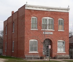 | Bradshaw Town Hall | building | 1984 | 84002499 |
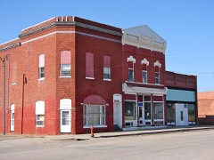 | Clem's Opera House | building | 1988 | 88000949 |
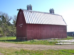 | W. S. Jeffery Farmstead | building | 1982 | 82003208 |
| York Auditorium | building | 2023 | 100008681 | |
 | York Public Library | building | 1990 | 90001765 |
 | York Subway | structure | 1992 | 92000772 |
Every wildfire the federal occurrence database records inside this county: 110 of them, burning about 666 acres. None started naturally and 7 were recorded as arson. Each settlement page carries the fires within five miles of it.
| Reported cause | Fires |
|---|---|
| Debris and open burning | 34 |
| Missing data/not specified/undetermined | 28 |
| Equipment and vehicle use | 23 |
| Power generation/transmission/distribution | 9 |
| Arson/incendiarism | 7 |
| Fireworks | 4 |
| Recreation and ceremony | 2 |
| Smoking | 2 |
| Railroad operations and maintenance | 1 |
The five largest, by the area the report gives. None of them was recorded as arson.
| Date | Cause | Size | Reported by | Name on the report |
|---|---|---|---|---|
| 9 March 2014 | Missing data/not specified/undetermined | 135 acres | Nebraska Forest Service | not named |
| 16 January 2014 | Power generation/transmission/distribution | 120 acres | Nebraska Forest Service | not named |
| 31 January 2012 | Debris and open burning | 100 acres | Nebraska Forest Service | not named |
| 2 April 2009 | Debris and open burning | 45 acres | Nebraska Forest Service | not named |
| 25 April 2019 | Debris and open burning | 20 acres | Nebraska Forest Service | not named |
| 19 March 2014 | Debris and open burning | 20 acres | Nebraska Forest Service | not named |
| 5 October 2011 | Equipment and vehicle use | 20 acres | Nebraska Forest Service | not named |
| 4 April 2019 | Missing data/not specified/undetermined | 20 acres | Nebraska Forest Service | not named |
Every settlement page carries the fires within five miles of it - see the settlement index below.
The NOAA Storm Events Database holds 521 reports for this county, causing 2 deaths, 36 injuries and about $92,820,000 in recorded property damage. Each settlement page carries the reports that name it.
| Kind of event | Reports |
|---|---|
| Hail | 260 |
| Thunderstorm Wind | 158 |
| Tornado | 49 |
| Heavy Rain | 24 |
| Flash Flood | 16 |
| Funnel Cloud | 9 |
| Flood | 3 |
| Lightning | 2 |
The most serious of them, by death, then injury, then recorded damage. The accounts are quoted exactly as the forecast office filed them.
| When | Event | Place named | Harm | What the report says |
|---|---|---|---|---|
| May 1964 | Tornado (F5) | not stated | 2 killed, 30 hurt, $2,500,000 | no account filed |
| March 1990 | Tornado (F4) | not stated | 2 hurt, $25,000,000 | no account filed |
| June 2022 | Tornado (EF2) | Lushton | 2 hurt, $1,200,000 | Amongst the widespread damage from wind and hail, it was determined an EF2 tornado occurred. The tornado formed about two miles west-southwest of Lushton and immediately damaged three farmsteads. Damage included, but was not limited to the following: a garage being torn from a home; several outbuildings destroyed; extensive tree damage; irrigation pivots overturned; grain bins destroyed. Signs of leaf and mud splatter, lofted debris, and a multi-directional/convergent damage pattern was noted. Two minor injuries occurred. ||The tornado wind field may have been as wide as 400 yards at times. The tornado climbed out of the Big Blue River Valley and moved northeast toward the northwest side of Lushton. A farmstead just northwest of town was damaged, including a completely destroyed wood frame outbuilding, uprooted trees and some structural damage to the home. The structural damage was most likely caused by a large portion of the outbuilding hitting the home. In Lushton, there was widespread tree damage. A very large grain bin was destroyed, along with a smaller one.||The rating of EF2 and maximum wind speed estimate of 115 MPH was given based on power poles snapped north-northeast of Lushton. The tornado continued east-northeast and upset more pivots, destroyed grain bins, snapped power poles and caused tree damage. The tornado lifted about two miles west of McCool Junction. |
| May 1998 | Thunderstorm Wind | York | 1 hurt, $500,000 | no account filed |
| July 1994 | Tornado (F0) | Benedict | 1 hurt | A small tornado touched down near Benedict, overturned a mobile home, damaged a grain bin and caused one injury. |
| June 2022 | Thunderstorm Wind | York | $10,000,000 | Wind gusts were estimated to be near 60 MPH. Hail ranged in size from quarters to 2.5 inches in diameter in York. Some tree and canopy damage was reported on the York College campus. |
| June 2022 | Thunderstorm Wind | Waco | $10,000,000 | Wind gusts in this area were estimated to have peaked near 105 MPH. Damage included a number of overturned irrigation pivots and snapped wooden power poles. A large outbuilding was also damaged, an approximately 60 foot tall concrete silo was toppled, and a grain bin was blown off its foundation and into a nearby field. |
| June 2022 | Hail | York | $10,000,000 | Hail ranging in size anywhere from quarters to 2.5 inches in diameter was reported across York and in Waco. The largest stones of 2-2.5 inches in diameter were reported in the city of York. Wind gusts estimated to be near 60 MPH was reported in York. Damage to trees and canopies on the York College campus was reported. |
| June 2022 | Hail | York | $8,000,000 | Most hail in and around York ranged in size from quarters to ping pong balls. The largest hail, tennis ball size, was reported by a storm chaser on the east side of York. |
| June 2011 | Tornado (EF2) | Henderson | $3,500,000 | This tornado touched down approximately 4 miles southwest of Bradshaw, moving to the north-northeast and dissipating approximately 4 miles southeast of Polk, near the York and Polk County line. As the tornado approached Highway 34 west of Bradshaw, a metal outbuilding and grain bins were destroyed, and it also crossed a railroad line, derailing several train cars. North of Bradshaw, a home suffered significant roof damage and the loss of one wall, and as the tornado continued north, power poles were snapped, irrigation pivots were overturned, and several trees were damaged. Between Bradshaw to the area west of Benedict, a total of 40 power poles were downed. The maximum wind speed of this tornado was estimated to be 130 MPH. |
| May 2005 | Flash Flood | Countywide | $2,000,000 | no account filed |
| May 2014 | Tornado (EF3) | Mc Cool Jct | $1,500,000 | This is a continuation of the tornado that started in northern Fillmore County. This tornado was the second to be rated an EF3 that affected south central Nebraska, starting in far northern Fillmore County before traversing a portion of York County and passing north of Cordova in Seward County. Damage along the track in Fillmore County was widespread, including one home which was totally destroyed. All 6 occupants took shelter in the basement. Another home suffered less significant damage, but outbuildings on the same property were destroyed. Also along the path of this tornado, and to the south of the path where rear flank downdraft winds occurred, numerous irrigation pivots were overturned, power poles were broken as well as trees and grain bins either damaged or destroyed. The strongest and widest time of this tornado occurred in Seward County, with a peak wind estimated to be 140 MPH and a maximum width of 2,640 yards, or 1.5 miles. |
| May 2013 | Tornado (EF1) | Mc Cool Jct | $1,500,000 | This tornado touched down approximately 5 miles south of York, traveling along a 16 mile path before lifting 12 miles northeast of York. It crossed over Interstate 80 approximately 1.3 miles east of the York interchange. This tornado had a maximum width of 400 yards and maximum wind speed estimated to be 110 MPH. Along this path, power poles and trees were snapped, large branches up to 12 to 18 inches in diameter were downed and irrigation pivots were overturned. Two outbuildings were damaged or destroyed. |
| July 2023 | Thunderstorm Wind | Thayer | $1,250,000 | Wind gusts estimated to be at least 75 MPH, accompanied by hail up to the size of quarters, resulted in widespread damage mainly focused in the Waco area. Multiple irrigation pivots were overturned, a few grain bins were damaged or destroyed, trees were damaged, and power outages were reported in the area. Wind-driven hail shredded crops, with several fields a total loss. South of Waco, damage was reported at the travel center at the Interstate 80 interchange. At a campground just south of the interchange, power lines were downed, fencing was damaged, and a few RVs were tipped over. Local fire departments reported that there around six semi-trucks flipped on Interstate 80. |
| May 2011 | Hail | York | $1,000,000 | Hail up to 3 inches in diameter fell in York for several minutes. The roof of a city elementary school was totaled by the hail. |
| April 2005 | Hail | York | $1,000,000 | no account filed |
| June 2022 | Thunderstorm Wind | Mc Cool Jct | $500,000 | Wind gusts estimated to be near 75 MPH resulted in widespread tree damage and sporadic building damage across McCool Junction. |
| July 2021 | Thunderstorm Wind | Henderson | $500,000 | Wind gusts estimated to be at least 65 MPH resulted in tree damage in Henderson, including some larger trees. Tree limbs were downed onto roads, making travel difficult in town. A nearby mesonet located two miles east-northeast of Henderson measured a peak gust of 60 MPH at 11:10 PM CDT. |
| June 2015 | Flood | Bradshaw | $500,000 | Multiple rounds of heavy rainfall totaled generally 4-7 across much of York County between the 3rd-6th, with the majority of this rain falling on the 4th-5th. Localized road flooding was initially reported in the York area on the evening of the 4th. Over the next few days, the main story turned to the West Fork Big Blue River in the southern part of the county, as significant flooding worked its way downstream, reaching the McCool Junction area on Saturday the 6th. Parts of McCool Junction were closed off due to flood waters and at least two homes were flooded. However, at least five homes were saved due to sandbagging efforts. All county roads crossing the river in southern York County were blocked off. Reports indicated that this may have bee some the worst flooding observed along the West Fork Big Blue in 50-80 years. Among other impacts, flood water entered Camp Kateri and the camp area was evacuated. A few days of warm and dry weather settled in from June 7-9, allowing flood waters to largely recede. However, another focused swath of 1.50-3.00 of heavy rain targeted the York and northern Fillmore counties area on the night of the 10th into the morning of the 11th. This again pushed the West Fork Big Blue River out of its banks in the McCool Junction area from the 11th into the 12th, before this multiple-day flooding event finally came to a close (see episode narrative for more details). |
| May 2013 | Tornado (EF1) | York Arpt | $500,000 | This tornado touched down approximately 3 miles northwest of York, traveling along a 9 mile path before lifting approximately 12 miles northwest of York. This tornado had a maximum width of 150 yards and maximum wind speed estimated to be 100 MPH.|Along this path, trees were damaged or uprooted, power poles were snapped and irrigation pivots overturned. There were a couple residences which suffered minor damage, but one garage was destroyed. Outbuildings and grain bins were also damaged or destroyed. |
| June 2022 | Hail | Mc Cool Jct | $400,000 | Hail up to two inches in diameter was reported in/near McCool Junction. |
| June 2022 | Thunderstorm Wind | Mc Cool Jct | $400,000 | Wind gusts estimated to be near 60 MPH were observed in McCool Junction. Hail up to two inches in diameter was also reported. |
| July 2022 | Thunderstorm Wind | Waco | $300,000 | A heat burst from decaying thunderstorms produced wind gusts over 60 MPH, with a peak gust of 67 MPH measured by a mesonet station located four miles south-southwest of Waco. An NeRain observation comment noted there were irrigation pivots flipped in the area. |
| June 2022 | Thunderstorm Wind | Lushton | $250,000 | A wind gust of 90 MPH was measured by a mesonet station located two miles east-northeast of Lushton. |
| December 2021 | Thunderstorm Wind | Waco | $250,000 | Wind gusts estimated to be near 75 MPH resulted in overturned irrigation pivots and a barn being damaged. |
| December 2021 | Thunderstorm Wind | Bradshaw | $250,000 | Emergency management reported irrigation pivot damage in the area. |
| June 2019 | Hail | Mc Cool Jct | $250,000 | Quarter to golf ball sized hail was reported. |
| August 2018 | Hail | Bradshaw | $250,000 | Hail lasted for approximately 15 minutes, ranging in size from quarters to 2 inches in diameter. |
| August 2018 | Hail | York Arpt | $250,000 | Hail up to the size of half dollars was reported in and around York. |
| June 2014 | Hail | York | $250,000 | Golfball size hail was covering the ground. |
| August 2018 | Hail | Benedict | $250,000 | no account filed |
| August 2018 | Hail | Waco | $250,000 | no account filed |
| June 2005 | Hail | York | $250,000 | no account filed |
| May 1998 | Tornado (F1) | Mc Cool Jct | $250,000 | no account filed |
| May 1998 | Tornado (F0) | Benedict | $250,000 | no account filed |
| March 1985 | Tornado (F1) | not stated | $250,000 | no account filed |
| June 1977 | Tornado (F1) | not stated | $250,000 | no account filed |
| April 1976 | Tornado (F1) | not stated | $250,000 | no account filed |
| June 1971 | Tornado (F1) | not stated | $250,000 | no account filed |
| June 1957 | Tornado (F3) | not stated | $250,000 | no account filed |
| May 2022 | Thunderstorm Wind | York | $200,000 | Wind gusts were estimated to be near 75 MPH in the area. Visibility was near-zero due to blowing dust, semi-trucks were tipped over along Interstate 80 in the area. |
| May 2014 | Flash Flood | Henderson | $200,000 | A widespread swath of 3 to at least 4 inches of rain fell, resulting in the closure of numerous county roads across southern portions of York County. |
| June 2002 | Hail | Gresham | $200,000 | no account filed |
| July 2023 | Hail | Waco | $150,000 | no account filed |
| April 2012 | Hail | Mc Cool Jct | $150,000 | no account filed |
| July 2000 | Flash Flood | South Portion | $150,000 | no account filed |
| June 2014 | Thunderstorm Wind | Henderson | $125,000 | A line of thunderstorms with damaging wind gusts near 65 MPH moved across the county. Tree damage was reported in McCool Junction, including large limbs up to 15 inches in diameter. |
| May 2013 | Hail | Henderson | $125,000 | Half dollar to golf ball size hail was reported. |
| September 2016 | Hail | York | $125,000 | no account filed |
| July 2011 | Thunderstorm Wind | Waco | $120,000 | Wind gusts were estimated at 60 to 70 MPH. Numerous tree limbs were blown down in town, some a foot or more in diameter. Approximately 2.5 miles southeast of town, 3 grain bins were destroyed and an irrigation pivot was overturned. |
| June 2020 | Thunderstorm Wind | York Arpt | $100,000 | A wind gust of 79 MPH was recorded by the York Airport AWOS. Law enforcement reported downed power lines and resultant power outages across town and that 2 homes sustained damage due to fallen trees. The York News-Times reported that an unoccupied car was partially-crushed by a fallen tree on West Sixth Street. |
| May 2019 | Flood | Arborville | $100,000 | Heavy rainfall resulted in flooding along area creeks and rivers across York County, including Lincoln Creek and the West Fork of the Big Blue River. Numerous rural roads and bridges were covered with water. A camp located just south of McCool Junction was inaccessible for multiple days. |
| August 2018 | Thunderstorm Wind | York Arpt | $100,000 | This wind gust actually occurred at the York Airport (the latitude/longitude is correct). |
| June 2014 | Hail | York | $100,000 | Along with the golf ball size hail, wind gusts were estimated to be 70 mph, blowing down 2 to 4 inch diameter branches at the eastbound I-80 rest area in York County. |
| June 2014 | Hail | Mc Cool Jct | $100,000 | Wind gusts estimated at 50 to 55 mph occurred along with the golf ball size hail. |
| May 2011 | Hail | York | $100,000 | no account filed |
| April 2005 | Heavy Rain | York | $100,000 | no account filed |
| April 2005 | Flash Flood | Waco | $100,000 | no account filed |
| April 2005 | Flash Flood | York | $100,000 | no account filed |
| June 2005 | Hail | Benedict | $100,000 | no account filed |
2 books written about this county, cut here where the book itself is cut, at its printed chapters: 7 chapters in all. Every chapter is public domain, machine-read from the scan and reproduced complete. A chapter already given under one of the county's towns is not repeated in this list.
| Chapter | Length |
|---|---|
| The whole text | 61,609 words in 4 parts |
| Chapter | Length |
|---|---|
| Chapter 21: York County in the World War | 26,030 words in 2 parts |
| Chapter with an unread heading (no. 2 of those read) | 10,831 words |
| Chapter 16: Banking and Financial Institutions | 6,014 words |
| Chapter 17: The Peess of York County | 11,878 words |
| Chapter 18: The Medical Profession | 21,511 words in 2 parts |
| Biographical sketches | 199,870 words in 13 parts |
Named settlements recorded in the Geographic Names Information System, each with the topographic sheets covering it. Villages, hamlets and abandoned places alike. Each is shown with the nearest named watercourse or landform and the survey quadrangle it falls on.
Baker precinct · 68467 · York SW quadrangle
15 sheets, 1898 to 1985
No longer a settlement
Hays precinct · 68401 · On Galaway Creek · Fairmont quadrangle
15 sheets, 1898 to 1985
The vanished settlements of York County: the places named above that are no longer on the map.