 Block
From the record
One of 16 National Register listings published here for Saunders County · listed in 2001 · category: Building.
Sources: the case file at the National Archives · the National Register database, National Park Service
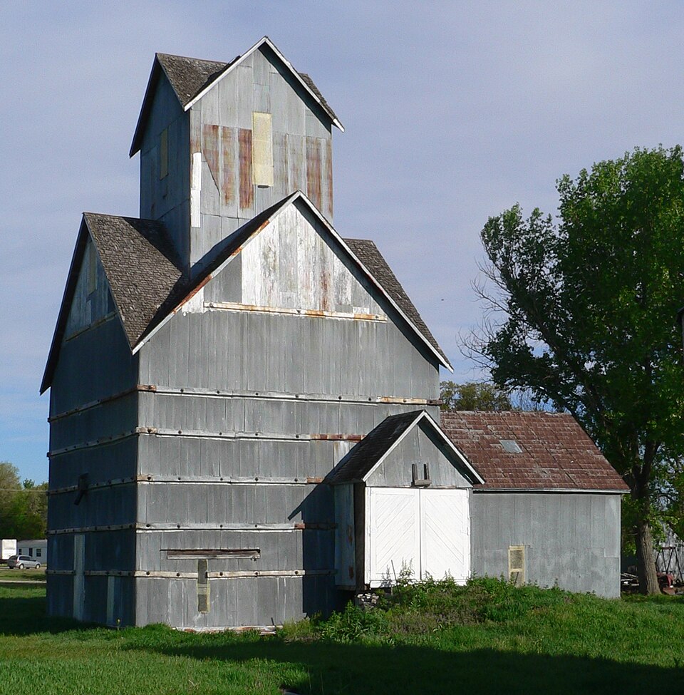
Listed on the National Register of Historic Places in 2001.
One of 16 National Register listings published here for Saunders County · listed in 2001 · category: Building.
Sources: the case file at the National Archives · the National Register database, National Park Service
Regional context, not property-specific evidence. The federal wildfire occurrence database lists 39 fires within 5 miles of Ithaca Grain Elevator, Old between 2006 and 2020, burning about 118 acres in total. None started naturally. None was recorded as arson. Distance is straight-line from the map coordinates, so a fire counted here may appear on a neighbouring settlement's page as well.
| Reported cause | Fires |
|---|---|
| Debris and open burning | 19 |
| Equipment and vehicle use | 12 |
| Missing data/not specified/undetermined | 4 |
| Smoking | 2 |
| Recreation and ceremony | 1 |
| Fireworks | 1 |
The most recent of them, most recent first, with the day each was reported and the service that recorded it.
| Date | Cause | Size | Reported by | Name on the report |
|---|---|---|---|---|
| 27 September 2007 | Equipment and vehicle use | 2.0 acres | Nebraska Forest Service | not named |
| 19 September 2012 | Equipment and vehicle use | 1.0 acres | Nebraska Forest Service | not named |
| 18 September 2012 | Equipment and vehicle use | 10 acres | Nebraska Forest Service | not named |
| 12 August 2020 | Missing data/not specified/undetermined | 1.0 acres | Nebraska Forest Service | not named |
| 9 July 2007 | Equipment and vehicle use | under an acre | Nebraska Forest Service | not named |
| 8 July 2007 | Smoking | under an acre | Nebraska Forest Service | not named |
| 4 July 2006 | Fireworks | 1.0 acres | Nebraska Forest Service | not named |
| 7 June 2007 | Missing data/not specified/undetermined | under an acre | Nebraska Forest Service | not named |
Regional context, not property-specific evidence. The National Weather Service names Ithaca, the town this property stands in, in 19 storm reports between 1993 and 2021: 8 hail, 4 thunderstorm wind, 3 flood, 2 tornado. No death or injury is recorded in these reports. Each account below is quoted exactly as the forecast office filed it, from the NOAA Storm Events Database, and each date opens the federal record of that event.
| When | Event | Place named | Harm | What the report says |
|---|---|---|---|---|
| August 2014 | Flood | Ithaca | $5,000 | Repeated thunderstorms on the 27th and 28th of August caused heavy rainfall and the Wahoo Creek to go into flood. The creek rose above flood stage on the morning of the 28th, the river created during the early morning on the 29th and fell below flood stage later that evening. The flooding was generally minor and confined to low-lying areas along the river. |
| April 2001 | Tornado (F0) | Ithaca | $5,000 | Brief touchdown of a tornado reported by amateur radio operator, also caught on film by 2 different tv meteorologists. The tornado struck a farm, picked up a camper and blew it around and damaged a few shingles and broke a few windows on a farm house according to the Mead Fire Chief. |
| May 1993 | Thunderstorm Wind | Ithaca | $5,000 | Thunderstorm winds damaged two farm buildings and knocked down tree limbs. |
| May 2014 | Flash Flood | Ithaca | $2,000 | Several roads around Ithica were briefly closed due to flash flooding. |
| December 2021 | Thunderstorm Wind | Ithaca | - | Mesonet measured a peak wind gust of 99 mph. |
| December 2021 | Tornado (EF1) | Ithaca | - | A short track EF-1 tornado began just west of CR 13 and traveled over a farmstead. This tornado caused substantial damage to several outbuildings and a grain bin. A cattle feeder that was secured to the ground via 3-foot-deep concrete posts was lifted and thrown 250 feet. The tornado was short lived with only tree damage observed at the end of the track. |
| August 2021 | Thunderstorm Wind | Ithaca | - | Personal weather station recorded a maximum wind gust of 50 kts. |
| December 2015 | Flood | Ithaca | - | Heavy rainfall in mid December led to minor flooding along the Wahoo Creek at both Ithaca downstream to Ashland. The river crested at 19.37 feet or .37 feet above flood stage at Ithaca, and at 19.11 feet or .11 feet above flood stage at Ashland. Flooding was minor and confined to agricultural land right along the river. |
| May 2014 | Flash Flood | Ithaca | - | Flash flooding briefly closed the intersection of County Rd 14 and Highway 66. |
| June 2011 | Hail | Ithaca | - | Hail up to 2 inches fell in the Ithaca area with some reports of sky lights broken because of the hail. |
| September 2010 | Hail | Ithaca | - | Hail up to baseball-size caused significant house and vehicle damage in the Ithaca area. The hail was accompanied by winds that gusted to at least 50 mph. By some accounts the hail lasted up to 45 minutes. Almost every house in town had siding damage and/or windows broken out, mainly on the north side of the house. Vehicles also sustained damage as did trees and other structures. Some crops east of town were shredded to the ground. |
| March 2007 | Hail | Ithaca | - | Very large hail was reported around the Ithaca area. A few stones were as large as 3 inches in diameter. |
| May 2007 | Flood | Ithaca | - | Rainfall of 3 to 5 inches fell over the lower sections of the Wahoo Creek basin from Friday May 4th through Sunday May 6th. The heavy rain caused Wahoo Creek to flood, mainly from just downstream of Wahoo to where it merges with Salt Creek near Ashland. At Ithaca the creek surpassed it's 19 foot flood stage around 9 am CDT on May 6th, reached a 20.7 foot crest at 5 pm and fell below flood stage around 1015 pm that day. The water flooded several county roads and Highway 66 near Ashland. A baseball field was also flooded. |
| June 2002 | Thunderstorm Wind | Ithaca | - | Thunderstorm wind gusts damaged large tree branches and knocked power out in Ithaca. From the same storm system that did the tree damage around Wahoo. |
| April 2001 | Hail | Ithaca | - | Car window reported fractured by the hail. |
| June 2014 | Hail | Ithaca | - | no account filed |
| June 2014 | Hail | Ithaca | - | no account filed |
| May 2012 | Hail | Ithaca | - | no account filed |
| April 2002 | Hail | Ithaca | - | no account filed |
No historic map-sheet match is published for this property yet. That does not mean no map exists. This record needs a coordinate-quality review before it can be joined to a sheet boundary. Browse the county's mapped places while that work is pending.
Other National Register properties close enough to walk or drive between, ordered by distance from this one. Both positions come from the same geocoding pass that matched these properties to their map sheets.
| Photograph | Property | Distance | Listed |
|---|---|---|---|
 | O. K. Market | 5.1 miles | 1991 |
 | Wahoo Burlington Depot | 5.2 miles | 1985 |
 | F.J. Kirchman House | 5.7 miles | 2003 |
 | Howard Hanson House | 5.8 miles | 1983 |
| National Archives record | The nomination case file for reference 01000168 in Record Group 79. |
| Saunders County | All 16 listed properties in this county. |