
BlockBefore
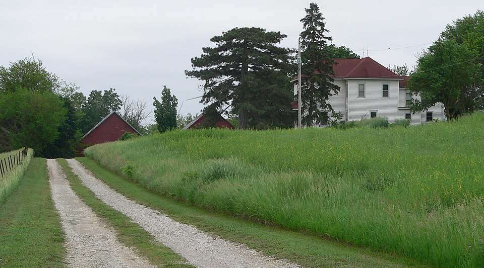
Photograph of Alfred and Magdalena Schmid Farmstead
Photograph by Ammodramus, CC0 1.0. Via Wikimedia Commons.

Alfred and Magdalena Schmid Farmstead

Built in 1917. Listed on the National Register of Historic Places in 2005.

From the record

“The Alfred and Magdalena Schmid Farmstead is a historic estate with a farm house, four barns and several outbuildings in Dawson, Nebraska. The farm house was built by Charlie Cordell in 1917 for Alfred Schmid and his wife, née Magdalena Kanel, both immigrants from Switzerland.”

Wikipedia article Alfred and Magdalena Schmid Farmstead, CC BY-SA 4.0.

One of 11 National Register listings published here for Richardson County · listed in 2005 · category: Building · built in 1917.

Sources: the Wikipedia article · the case file at the National Archives · the National Register database, National Park Service
The listing

  • What is counted as historic. The nomination lists 8 buildingss as contributing to the listing.
  • Listed as. Schmid, Alfred and Magdalena, Farmstead - the National Register files a house under its owner's surname.
  • Address. RR1, Dawson, 68337
  • When was it listed? November 2005
  • Category. building
  • Precinct. Nemaha precinct
  • When was it built? 1917
  • National Register reference number. 05001292 - the number the National Park Service assigned this property when it was listed, and the key its nomination file is catalogued under at the National Archives.

The ground it stands on

1,551 words

The chapter on Nemaha Precinct in History of Richardson County, Nebraska : Its People, Industries and Institutions, published 1917 names Dawson. This is what it says, exactly as the scans read.

Falls City, the county seat, with a reported population of 3,255, is located in the southeastern section at a junction of two railroads, and is a distributing point for farm implements and supplies. Humboldt, Rulo, Stella, Verdon, Salem, Preston, Dawson, and Shubert are other towns of local importance. Straussville is a, railroad point. Barada and Nim City are small inland towns.

Passage source: History of Richardson County, Nebraska : Its People, Industries and Institutions, published 1917.

Machine-read from a century-old scan, so expect the errors a machine makes: misspelled names, dropped words, stray characters.

Read the whole chapter on Nemaha Precinct - 1,551 words on its settlement, mills, schools and churches.

Fires near this property

14 since 2001

Regional context, not property-specific evidence. The federal wildfire occurrence database lists 14 fires within 5 miles of Alfred and Magdalena Schmid Farmstead between 2001 and 2019, burning about 654 acres in total. None started naturally. None was recorded as arson. Distance is straight-line from the map coordinates, so a fire counted here may appear on a neighbouring settlement's page as well.

Reported cause Fires
Debris and open burning13
Missing data/not specified/undetermined1

The most recent of them, most recent first, with the day each was reported and the service that recorded it.

DateCause SizeReported by Name on the report
2 May 2001Debris and open burning5.0 acresHorton AgencyFESTUS
30 April 2001Debris and open burning1.0 acresHorton AgencyDILLON
25 April 2001Debris and open burning160 acresHorton AgencyKICK
25 April 2001Debris and open burning17 acresHorton AgencyLOST
25 April 2001Debris and open burning2.0 acresHorton AgencyWAGON
25 April 2001Debris and open burning1.0 acresHorton AgencyOLD
25 April 2001Debris and open burning220 acresHorton AgencyPOO
22 April 2001Debris and open burning58 acresHorton AgencySAC

Every fire recorded in Richardson County

Storms near this property

18 since 1996

Regional context, not property-specific evidence. The National Weather Service names Dawson, the town this property stands in, in 18 storm reports between 1996 and 2025: 7 hail, 5 thunderstorm wind, 4 tornado, 1 heavy rain. No death or injury is recorded in these reports. Each account below is quoted exactly as the forecast office filed it, from the NOAA Storm Events Database, and each date opens the federal record of that event.

WhenEvent Place namedHarm What the report says
July 1996Tornado (F0)Dawson$10,000no account filed
February 2000Thunderstorm WindDawson$1,000Window blown out of a house, wind damage to outbuildings.
May 2025HailDawson-Storm chaser report of hail measured up to 1 in diameter.
April 2024Funnel CloudDawson-The National Weather Serivce in Topeka relayed a report to the Omaha-Valley National Weather Service of a funnel cloud in Richardson County, to the east of Du Bois.
July 2023Thunderstorm WindDawson-NWS employee reported an estimated 60 mph wind gust.
July 2020Thunderstorm WindDawson-Rural carrier reported several locations with trees or large limbs down on or near roads south of Dawson and Humbuldt.
May 2019Tornado (EFU)Dawson-Storm chasers and a sheriff deputy collected video of a small tornado that moved north-northeast in open fields south of Dawson, NE. No discernible damage was noted from this tornado.
May 2019Heavy RainDawson-An observer measured 3.82 inches of rain southeast of Dawson in the previous 24 hours.
May 2019Tornado (EFU)Dawson-A storm chaser videoed a brief touched down near NE Highway 8 south of Dawson.
March 2012HailDawson-Hail nickel to quarter-size fell for several minutes covering the ground white.
June 2011HailDawson-Hail up to 1.5 inches in diameter fell along with thunderstorm wind gusts of over 60 mph.
June 2011Thunderstorm WindDawson-Thunderstorm wind gusts estimated at over 60 mph blew down a tree across Highway 75 a little south of the intersection of Highway 8. The winds were accompanied by hail which reached up to 1.5 inches in diameter.
August 2007Thunderstorm WindDawson-Thunderstorms winds snapped a power pole in the vicinity...wind speed was estimated at 65 mph.
May 2001Tornado (F0)Dawson-A line of mini-supercells moved north across southeast Nebraska this late afternoon and early evening. The storms produced several small and short-lived tornadoes that touched down from west of Falls City up to south of Auburn. This was the first report of a touchdown with this outbreak. The tornadoes apparently all touched down in open areas, were short-lived and produced very little or no damage.
May 2018HailDawson-no account filed
April 2017HailDawson-no account filed
May 2010HailDawson-no account filed

Every storm recorded in Richardson County

Map coverage status

No historic map-sheet match is published for this property yet. That does not mean no map exists. This record needs a coordinate-quality review before it can be joined to a sheet boundary. Browse the county's mapped places while that work is pending.

Listed places nearby

1 within 8 miles

Other National Register properties close enough to walk or drive between, ordered by distance from this one. Both positions come from the same geocoding pass that matched these properties to their map sheets.

Photograph PropertyDistance Listed
Miles Ranch4.5 miles2012

Sources for this property

National Archives recordThe nomination case file for reference 05001292 in Record Group 79.
Wikipedia articleCommunity-written account of this property, licensed CC BY-SA.
Richardson CountyAll 11 listed properties in this county.

Provenance

  • Listing record. National Park Service National Register of Historic Places, listed-properties dataset, current to 2026-05-22.
  • Map join. Address geocoded through the United States Census geocoder, then tested against the published boundary of every sheet in the USGS Historical Topographic Map Collection.
  • How this page is made. Listing fields come from federal records; map-sheet coverage is a labelled coordinate-to-boundary calculation, not a source-field claim.
  • Wildfire. Short, Karen C. 2022. Spatial wildfire occurrence data for the United States, 1992-2020 [FPA_FOD_20221014]. 6th Edition. Fort Collins, CO: Forest Service Research Data Archive. https://doi.org/10.2737/RDS-2013-0009.6 Collected with United States Government funding and usable without additional permissions or fees.
  • Storms. NOAA National Centers for Environmental Information, Storm Events Database https://www.ncei.noaa.gov/stormevents/ A work of the United States government, no copyright under 17 U.S.C. 105. Narratives are quoted verbatim from the National Weather Service report and are not edited or summarised.