 Block
From the record
One of 9 National Register listings published here for Dawson County · listed in 2018 · category: District.
Sources: the National Register database, National Park Service
Listed on the National Register of Historic Places in 2018.
One of 9 National Register listings published here for Dawson County · listed in 2018 · category: District.
Sources: the National Register database, National Park Service
Regional context, not property-specific evidence. The federal wildfire occurrence database lists 16 fires within 5 miles of Cozad Downtown Historic District between 2006 and 2017, burning about 438 acres in total. None started naturally. None was recorded as arson. Distance is straight-line from the map coordinates, so a fire counted here may appear on a neighbouring settlement's page as well.
| Reported cause | Fires |
|---|---|
| Equipment and vehicle use | 6 |
| Debris and open burning | 6 |
| Missing data/not specified/undetermined | 2 |
| Power generation/transmission/distribution | 1 |
| Recreation and ceremony | 1 |
The most recent of them, most recent first, with the day each was reported and the service that recorded it.
| Date | Cause | Size | Reported by | Name on the report |
|---|---|---|---|---|
| 4 September 2007 | Equipment and vehicle use | under an acre | Nebraska Forest Service | not named |
| 21 September 2007 | Equipment and vehicle use | under an acre | Nebraska Forest Service | not named |
| 9 July 2017 | Debris and open burning | 4.0 acres | Nebraska Forest Service | not named |
| 6 July 2015 | Equipment and vehicle use | 3.0 acres | Nebraska Forest Service | not named |
| 21 May 2012 | Debris and open burning | under an acre | Nebraska Forest Service | not named |
| 14 May 2008 | Missing data/not specified/undetermined | 1.0 acres | Nebraska Forest Service | not named |
| 3 April 2015 | Equipment and vehicle use | 100 acres | Nebraska Forest Service | not named |
| 29 April 2008 | Debris and open burning | 1.0 acres | Nebraska Forest Service | not named |
Regional context, not property-specific evidence. The federal mineral resources record lists 1 working within 5 miles of Cozad Downtown Historic District: 1 producer. All of them still produce. What was taken out: Sand and Gravel, Construction. Distance is straight-line from the map coordinates, so a quarry counted here may appear on a neighbouring settlement's page as well.
| Where | Site | Commodity | Status | Recorded |
|---|---|---|---|---|
| Paulsen Building & Supply Inc. | Sand and Gravel, Construction | Producer |
Regional context, not property-specific evidence. The National Weather Service names Cozad, the town this property stands in, in 96 storm reports between 1994 and 2024: 58 hail, 33 thunderstorm wind, 2 tornado, 2 heavy rain. No death or injury is recorded in these reports. Each account below is quoted exactly as the forecast office filed it, from the NOAA Storm Events Database, and each date opens the federal record of that event.
| When | Event | Place named | Harm | What the report says |
|---|---|---|---|---|
| June 2024 | Hail | Cozad | $25,000,000 | Emergency management reported widespread significant damage across Cozad from large hail up to four inches in diameter. The local hospital was damaged enough from broken windows, roof damage, and leaking water that patients had to be transferred to nearby hospitals for a period of time. One injury was reported, a person was caught outside in the storm, suffering cuts and bruises and losing consciousness. |
| August 2019 | Thunderstorm Wind | Cozad | $1,500,000 | An 81 MPH wind gust was measured by a mesonet station located 1 mile north-northeast of Cozad. Emergency management reported tree damage and downed power lines in the area, along with overturned pivots. One of the more notable damage scenes involved Cozad High School, where a large portion of the roof was ripped off of the library, allowing rain water to pour in. This damaged thousands of books, along with shelving and some electronics. Nearby, a metal storage building was destroyed, parts of it lofted into a nearby home and piercing a hole in its roof. |
| August 2005 | Hail | Cozad | $1,000,000 | 70 mph winds accompanied the golf ball sized hail. |
| May 2019 | Tornado (EF1) | Cozad | $900,000 | This tornado was witnessed by many as it formed on the east side of Cozad, where some tree damage and power poles were broken. The nearly 10-mile path weaved to the northeast across a rural landscape. One-half of a large farm machinery shed was complete destroyed and several irrigation pivots were upset, helping delineate the path. Grain bins were destroyed and tree damage was sporadic along the path. The tornado was reported to be rain-wrapped at times. The path become indiscernible as the tornado moved into the hills north of Cozad and the road network became more sparse. The estimated maximum wind speed was 100 MPH. |
| June 2024 | Thunderstorm Wind | Cozad | $500,000 | Wind gusts estimated to be between 70 and 75 MPH resulted in overturned irrigation pivots in the area. Tree damage was also noted in and around the local country club. |
| September 2023 | Hail | Cozad | $100,000 | Walnut to golf ball size hail was reported in the area. |
| May 2018 | Thunderstorm Wind | Cozad | $100,000 | A few local businesses sustained minor roof damage, and some tin was blown off a few outbuildings. A large pine tree was uprooted, landing on a house. |
| August 1999 | Thunderstorm Wind | Cozad | $100,000 | no account filed |
| July 2017 | Thunderstorm Wind | Cozad | $75,000 | One irrigation pivot was overturned and a couple nearby fields sustained some crop damage. |
| July 2012 | Hail | Cozad | $75,000 | Hail up to the size of golf balls resulted in heavy damage to nearby soybean and corn fields. |
| July 2012 | Hail | Cozad | $75,000 | Hail up to the size of quarters resulted in heavy crop damage to nearby corn fields. |
| May 2011 | Thunderstorm Wind | Cozad | $75,000 | Wind gusts were estimated between 70 and 75 MPH. |
| May 2007 | Hail | Cozad | $50,000 | no account filed |
| June 2005 | Hail | Cozad | $50,000 | no account filed |
| May 2000 | Thunderstorm Wind | Cozad | $50,000 | no account filed |
| July 2000 | Hail | Cozad | $50,000 | no account filed |
| May 2013 | Hail | Cozad | $25,000 | no account filed |
| May 2012 | Hail | Cozad | $25,000 | no account filed |
| July 2004 | Thunderstorm Wind | Cozad | $25,000 | no account filed |
| July 2003 | Hail | Cozad | $25,000 | no account filed |
| August 1999 | Thunderstorm Wind | Cozad | $25,000 | no account filed |
| August 2016 | Thunderstorm Wind | Cozad | $20,000 | There were six to eight inch diameter tree limbs blown down from estimated 60 mph thunderstorm wind gusts. |
| June 2006 | Thunderstorm Wind | Cozad | $20,000 | no account filed |
| May 2012 | Hail | Cozad | $15,000 | no account filed |
| July 2006 | Thunderstorm Wind | Cozad | $15,000 | no account filed |
| May 2004 | Thunderstorm Wind | Cozad | $15,000 | no account filed |
| July 2004 | Hail | Cozad | $10,000 | 50 to 60 mph winds were also reported at the same time. |
| July 2003 | Thunderstorm Wind | Cozad | $10,000 | no account filed |
| October 2000 | Hail | Cozad | $10,000 | no account filed |
| August 2007 | Hail | Cozad | $5,000 | Winds up to 60 mph blew along with the hail. |
| April 2007 | Hail | Cozad | $5,000 | no account filed |
| June 2007 | Hail | Cozad | $5,000 | no account filed |
| August 2003 | Thunderstorm Wind | Cozad | $5,000 | no account filed |
| June 1998 | Hail | Cozad | $5,000 | no account filed |
| July 2023 | Thunderstorm Wind | Cozad | $2,000 | A wind gust of 62 MPH was measured by a mesonet station located one mile north-northeast of Cozad. A trained spotter reported minor tree damage in the area, with a few limbs strewn across Highway 30 between Cozad and Lexington. |
| July 2019 | Thunderstorm Wind | Cozad | $1,000 | A 60 MPH wind gust was measured by a personal weather station located 1 mile north-northeast of Cozad. In town, some shingles were blown off of a roof. Pea size hail was also reported. |
| April 2024 | Thunderstorm Wind | Cozad | - | A wind gust of 60 MPH was measured by a mesonet station located on the north-northeast side of Cozad. |
| August 2021 | Thunderstorm Wind | Cozad | - | A wind gust of 58 MPH was measured by a mesonet station located one mile north-northeast of Cozad. |
| May 2019 | Thunderstorm Wind | Cozad | - | A 58 MPH wind gust was measured by a mesonet site located 1 mile north-northeast of Cozad. |
| July 2019 | Thunderstorm Wind | Cozad | - | A wind gust of 63 MPH was measured by a mesonet station located 1 mile north-northeast of Cozad. |
| August 2019 | Thunderstorm Wind | Cozad | - | A 65 MPH wind gust was measured by a mesonet station located 1 mile north-northeast of Cozad. |
| May 2018 | Thunderstorm Wind | Cozad | - | Wind gusts were estimated to be near 60 MPH. |
| May 2016 | Thunderstorm Wind | Cozad | - | Wind gusts were estimated to be near 60 MPH. |
| June 2016 | Flash Flood | Cozad | - | Paved roads were flooded about five miles south of Cozad near the intersection of Road 755 and Avenue 423. This stretch of road was closed. |
| August 2015 | Thunderstorm Wind | Cozad | - | Wind gusts were estimated to be near 60 MPH, and were likely associated with a mesoscale convective vortex (MCV). The NWS coop observer in town reported small to medium tree limbs down across town. |
| August 2013 | Heavy Rain | Cozad | - | A 12 hour total of 3.90 inches of rain fell through 7 am CDT. This report was from the Nebraska Rainfall Assessment and Informtaion Network (NERAIN). |
| July 2012 | Thunderstorm Wind | Cozad | - | Wind gusts estimated at 60 mph were reported. |
| July 2012 | Thunderstorm Wind | Cozad | - | Wind gusts estimated at 60 mph were reported. |
| August 2012 | Hail | Cozad | - | Nickel size hail occurred for five minutes. |
| August 2012 | Heavy Rain | Cozad | - | A 24 hour rainfall total of 3.07 inches was reported, most of which fell during the overnight hours. |
| July 2011 | Thunderstorm Wind | Cozad | - | Wind gusts were estimated at 60 MPH. |
| June 2010 | Thunderstorm Wind | Cozad | - | Damage was reported to signs and a gazebo, and tree limbs 4 to 8 inches in diameter were knocked down. |
| June 2010 | Thunderstorm Wind | Cozad | - | Grown trees uprooted in town and 14 to 16 inch tree limb knocked down. |
| June 2004 | Hail | Cozad | - | Along with the nickel size hail, about 2 inches of rain was reported to have fallen in 30 minutes at Cozad. |
| May 2023 | Hail | Cozad | - | no account filed |
| May 2022 | Hail | Cozad | - | no account filed |
| May 2021 | Hail | Cozad | - | no account filed |
| June 2018 | Thunderstorm Wind | Cozad | - | no account filed |
| March 2017 | Hail | Cozad | - | no account filed |
| August 2017 | Hail | Cozad | - | no account filed |
No historic map-sheet match is published for this property yet. That does not mean no map exists. This record needs a coordinate-quality review before it can be joined to a sheet boundary. Browse the county's mapped places while that work is pending.
Other National Register properties close enough to walk or drive between, ordered by distance from this one. Both positions come from the same geocoding pass that matched these properties to their map sheets.
| Photograph | Property | Distance | Listed |
|---|---|---|---|
 | Allen's Opera House | under 500 feet | 1988 |
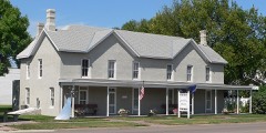 | Hendee Hotel | 0.1 miles | 1979 |
| National Archives record | The nomination case file for reference 100003093 in Record Group 79. |
| Dawson County | All 9 listed properties in this county. |