 Block
From the record
9 National Register listings published here.
Sources: the National Register database, National Park Service
53 topographic sheets cover 12 settlements here, and 9 properties are on the National Register of Historic Places.
9 National Register listings published here.
Sources: the National Register database, National Park Service
Every property in this county listed on the National Register of Historic Places, with the year it was listed and the federal nomination document.
| Photograph | Property | Type | Listed | Reference |
|---|---|---|---|---|
 | Allen's Opera House | building | 1988 | 88000951 |
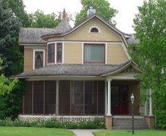 | Ernest A. Calling House | building | 1979 | 79001437 |
 | Carnegie Public Library | building | 1986 | 86003443 |
| Cozad Downtown Historic District | district | 2018 | 100003093 | |
 | Dawson County Courthouse | district | 1990 | 89002236 |
 | Hendee Hotel | building | 1979 | 79001436 |
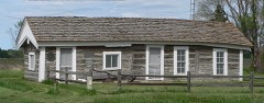 | Midway Stage Station | building | 1969 | 69000372 |
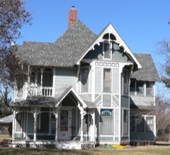 | Ira Webster Olive House | building | 1989 | 89002042 |
 | Temple, Harry V., House | building | 2019 | 100004608 |
Every wildfire the federal occurrence database records inside this county: 199 of them, burning about 2,658 acres. 8 started naturally and 2 were recorded as arson. Each settlement page carries the fires within five miles of it.
| Reported cause | Fires |
|---|---|
| Debris and open burning | 70 |
| Missing data/not specified/undetermined | 48 |
| Equipment and vehicle use | 38 |
| Power generation/transmission/distribution | 10 |
| Recreation and ceremony | 8 |
| Natural | 8 |
| Smoking | 6 |
| Fireworks | 4 |
| Railroad operations and maintenance | 3 |
| Misuse of fire by a minor | 2 |
| Arson/incendiarism | 2 |
The five largest, by the area the report gives. None of them was recorded as arson.
| Date | Cause | Size | Reported by | Name on the report |
|---|---|---|---|---|
| 18 August 2012 | Missing data/not specified/undetermined | 480 acres | Nebraska Forest Service | not named |
| 19 October 2018 | Equipment and vehicle use | 450 acres | Nebraska Forest Service | not named |
| 1 December 2009 | Equipment and vehicle use | 440 acres | Nebraska Forest Service | not named |
| 19 January 2009 | Equipment and vehicle use | 320 acres | Nebraska Forest Service | not named |
| 3 April 2015 | Equipment and vehicle use | 100 acres | Nebraska Forest Service | not named |
| 22 March 2007 | Equipment and vehicle use | 65 acres | Nebraska Forest Service | not named |
| 6 February 2009 | Equipment and vehicle use | 60 acres | Nebraska Forest Service | not named |
| 3 May 2015 | Debris and open burning | 60 acres | Nebraska Forest Service | not named |
Every settlement page carries the fires within five miles of it - see the settlement index below.
The NOAA Storm Events Database holds 720 reports for this county, causing 1 death, 20 injuries and about $98,052,590 in recorded property damage. Each settlement page carries the reports that name it.
| Kind of event | Reports |
|---|---|
| Hail | 367 |
| Thunderstorm Wind | 259 |
| Tornado | 58 |
| Flash Flood | 14 |
| Heavy Rain | 8 |
| Flood | 7 |
| Funnel Cloud | 5 |
| Lightning | 2 |
The most serious of them, by death, then injury, then recorded damage. The accounts are quoted exactly as the forecast office filed them.
| When | Event | Place named | Harm | What the report says |
|---|---|---|---|---|
| July 2019 | Flash Flood | Farnam | 1 killed, 1 hurt, $10,000 | A 46 year old female from Eustis died from injuries sustained in an automobile accident when she encountered flood waters over Highway 21 approximately 4 miles south of Cozad. The vehicle left the highway into a water-filled ditch and rolled onto its roof. The other occupant of the vehicle, the driver's 26 year old daughter, survived with minor injuries. |
| April 2007 | Tornado (EF2) | Gothenburg | 9 hurt, $2,500,000 | This tornado touched down southwest of Gothenburg and traveled north. It crossed Interstate 80 and passed about 2 miles west of the town of Gothenburg. The twister continued to the north and crossed from Dawson County into Custer County. |
| April 1974 | Tornado (F3) | not stated | 3 hurt, $2,500,000 | no account filed |
| April 1974 | Tornado (F3) | not stated | 3 hurt, $2,500,000 | no account filed |
| April 2001 | Hail | Lexington | 3 hurt, $15,000 | no account filed |
| April 1986 | Tornado (F1) | not stated | 1 hurt, $250,000 | no account filed |
| June 2024 | Hail | Gothenburg | $25,000,000 | There widespread reports of quarter to baseball size hail along and near this approximately 27 mile long path, causing widespread damage to vehicles, homes, and crops. The largest hail and most widespread vehicle and building damage occurred in Cozad. This hail was accompanied by wind gusts likely at least 50 MPH. |
| June 2024 | Hail | Cozad | $25,000,000 | Emergency management reported widespread significant damage across Cozad from large hail up to four inches in diameter. The local hospital was damaged enough from broken windows, roof damage, and leaking water that patients had to be transferred to nearby hospitals for a period of time. One injury was reported, a person was caught outside in the storm, suffering cuts and bruises and losing consciousness. |
| May 2005 | Flash Flood | Countywide | $3,000,000 | no account filed |
| March 1976 | Tornado (F1) | not stated | $2,500,000 | no account filed |
| April 1974 | Tornado (F3) | not stated | $2,500,000 | no account filed |
| May 2023 | Tornado (EF1) | Darr | $2,000,000 | A tornado developed within a line of thunderstorms northwest of Johnson Lake in far southern Dawson county just before 11:00 PM on Friday, May 5th. The tornado appeared to begin a couple miles northwest of the toppled three irrigation pivots before hitting the Lakeview Acres area on the northwest side of the lake. At least two large storage sheds were totally destroyed in that area. There were several instances of damage in the area, such as trees, smaller buildings, windows and some roof damage,|including two 2x4 stud driven into the roof of one home. The tornado traversed east across the lake and did significant damage to several homes on the east side of the lake right along the Gosper county line. Along the shore line, at least three homes in a row had all or part of a covered porch blown apart, and one home had a large section of its roof torn off. Another flat roof cabin had its entire roof torn off. A few power poles were snapped. Tree damage was common in this general area. The tornado moved east and upset an irrigation pivot and peeled back some metal roofing from a large building just east of the lake. The tornado likely dissipated east of County Road 428. The |maximum wind speed was estimated to be 95 MPH based upon the residential roof damage and the storage building being destroyed. The path was just under 5 miles long and the width was estimated to be 80 yards. |
| May 2014 | Hail | Lexington | $2,000,000 | Hail ranging in size from quarters to baseballs was reported in town by trained spotters and law enforcement officials. |
| July 2019 | Flash Flood | Overton | $2,000,000 | no account filed |
| August 2019 | Thunderstorm Wind | Cozad | $1,500,000 | An 81 MPH wind gust was measured by a mesonet station located 1 mile north-northeast of Cozad. Emergency management reported tree damage and downed power lines in the area, along with overturned pivots. One of the more notable damage scenes involved Cozad High School, where a large portion of the roof was ripped off of the library, allowing rain water to pour in. This damaged thousands of books, along with shelving and some electronics. Nearby, a metal storage building was destroyed, parts of it lofted into a nearby home and piercing a hole in its roof. |
| July 2024 | Hail | Gothenburg | $1,000,000 | Hail ranging in size from quarters to tennis balls was reported along this path. |
| July 2021 | Thunderstorm Wind | Gothenburg | $1,000,000 | Numerous measured gusts of 64 MPH to 78 MPH were reported along and near this path. The peak gust was 78 MPH, recorded at 10:11 PM CDT by a mesonet station located two miles east-southeast of Overton. Gusts of 75, 65, and 64 MPH were recorded between 9:34-9:44 PM by a mesonet station located one mile north-northeast of Cozad. Other gusts included 71 MPH (at 9:26 PM CDT by a mesonet station located three miles north-northwest of Gothenburg), 67 MPH (at 9:55 PM CDT by the Lexington Airport AWOS), and 66 MPH (at 9:50 PM CDT by a mesonet station located four miles west-northwest of Lexington). The Dawson Public Power District reported downed power lines and power outages in and around cities along this path. Tree damage was also reported. |
| August 2017 | Thunderstorm Wind | Lexington | $1,000,000 | Wind gusts estimated to be near 60 MPH accompanied hail to the size of golf balls. |
| July 2014 | Hail | Lexington | $1,000,000 | Hail ranging in size from quarters to half dollars was reported and accompanied wind gusts of 60 to 70 MPH. |
| July 2014 | Thunderstorm Wind | Lexington | $1,000,000 | Wind gusts near and in Lexington were estimated to be between 60 and 70 MPH. These winds accompanied hail ranging in size from quarters to half dollars. |
| August 2005 | Hail | Cozad | $1,000,000 | 70 mph winds accompanied the golf ball sized hail. |
| July 2024 | Hail | Lexington Arpt | $1,000,000 | no account filed |
| June 2022 | Hail | Lexington | $1,000,000 | no account filed |
| August 2017 | Hail | Lexington | $1,000,000 | no account filed |
| May 2019 | Tornado (EF1) | Cozad | $900,000 | This tornado was witnessed by many as it formed on the east side of Cozad, where some tree damage and power poles were broken. The nearly 10-mile path weaved to the northeast across a rural landscape. One-half of a large farm machinery shed was complete destroyed and several irrigation pivots were upset, helping delineate the path. Grain bins were destroyed and tree damage was sporadic along the path. The tornado was reported to be rain-wrapped at times. The path become indiscernible as the tornado moved into the hills north of Cozad and the road network became more sparse. The estimated maximum wind speed was 100 MPH. |
| June 2024 | Thunderstorm Wind | Willow Is | $500,000 | Wind gusts estimated to be between 70 and 90 MPH resulted in several overturned irrigation pivots and tree damage in the area, including larger snapped limbs and trunks. |
| June 2024 | Thunderstorm Wind | Cozad | $500,000 | Wind gusts estimated to be between 70 and 75 MPH resulted in overturned irrigation pivots in the area. Tree damage was also noted in and around the local country club. |
| July 2014 | Hail | Gothenburg | $500,000 | Ping pong ball size hail accompanied wind gusts of 60 MPH. |
| July 2014 | Thunderstorm Wind | Gothenburg | $500,000 | Wind gusts estimated at 60 MPH accompanied ping pong ball size hail. |
| May 2011 | Thunderstorm Wind | Lexington Arpt | $500,000 | Wind gusts up to 90 MPH caused tree damage, knocked down power lines and overturned pivots in the area. On the north side of Lexington, a fence at a ballfield was damaged. |
| August 1996 | Hail | Gothenburg | $500,000 | no account filed |
| May 2013 | Hail | Gothenburg | $400,000 | Hail ranging in size from quarters to golf balls was reported in Gothenburg. |
| August 1999 | Thunderstorm Wind | Gothenburg | $300,000 | no account filed |
| July 2024 | Hail | Willow Is | $250,000 | Hail up to two inches in diameter was reported in the area. |
| July 2024 | Hail | Lexington | $250,000 | Hail up to two inches in diameter was reported in the area. |
| September 2023 | Hail | Lexington Arpt | $250,000 | Storm chaser reported large hail, with isolated stones up to the size of softballs, south of the Darr exit of Interstate 80. Hail caused damage to their vehicle. |
| May 2019 | Tornado (EF1) | Farnam | $250,000 | This tornado uprooted some trees, caused minor damage to some homes and completely destroyed at least one storage building. The tornado crossed Highway 23 east of Farnam, then Highway 47 northeast of Farnam before dissipating. The path became indiscernible as the storm approached rougher terrain and the road network was not viable for surveying. The estimated maximum wind speed was 100 MPH. |
| August 2014 | Hail | Lexington | $250,000 | Hail ranging in size from golf balls to baseballs was reported and was accompanied by wind gusts estimated to be near 55 MPH. |
| June 2013 | Hail | Overton | $250,000 | Golf ball size hail fell in Overton. |
| June 2011 | Hail | Overton | $250,000 | Hail up to the size of ping pong balls was reported on Interstate 80. |
| July 2005 | Hail | Farnam | $250,000 | no account filed |
| September 2000 | Lightning | Lexington | $250,000 | no account filed |
| July 1987 | Tornado (F1) | not stated | $250,000 | no account filed |
| June 1984 | Tornado (F1) | not stated | $250,000 | no account filed |
| April 1975 | Tornado (F2) | not stated | $250,000 | no account filed |
| June 1959 | Tornado (F1) | not stated | $250,000 | no account filed |
| October 2023 | Tornado (EF0) | Overton | $225,000 | A short-lived tornado occurred about 3 miles northeast of Overton. This tornado upset at least two center irrigation pivots, and the associated rear flank downdraft damaged three more pivots. One farmstead reported tree damage. One helpful nugget of information was video from a nearby home showing the condensation funnel as it formed. The tornado likely dissipated in a pasture after a couple minutes. |
| October 2017 | Thunderstorm Wind | Lexington Arpt | $200,000 | Wind gusts estimated to be near 75 MPH resulted in some scattered irrigation pipes and larger tree limbs downed in the area. A section of roof from a grain bin was also removed by the wind. |
| May 2013 | Hail | Gothenburg | $200,000 | no account filed |
| May 2013 | Hail | Gothenburg | $200,000 | no account filed |
| July 2018 | Flash Flood | Sumner | $150,000 | Heavy rain fell across the warned area, and while actual ground-truth reports were only in the 3 to 5 inch range, radar estimation and unofficial reports exceeded 6 inches in east-central Dawson County. Emergency management reported that several rural roads and at least 2 homes were affected by water. The most significant report came from a home approximately 7 miles north-northwest of Overton. This home is located at the convergence point of a couple of drainage paths, and the heavy rainfall resulted in every room having at least 2 feet of water inside. All of the appliances and furniture were destroyed, and the interior will have to be completely redone once it's dried out. |
| June 2016 | Thunderstorm Wind | Lexington | $150,000 | Tree limbs that were 8 to 10 inches in diameter were blown down. |
| May 2004 | Thunderstorm Wind | Gothenburg | $150,000 | no account filed |
| May 2000 | Thunderstorm Wind | Gothenburg | $150,000 | no account filed |
| July 2024 | Hail | Buffalo | $125,000 | no account filed |
| July 2024 | Hail | Lexington | $125,000 | no account filed |
| October 2000 | Tornado (F2) | Darr | $125,000 | no account filed |
| September 2023 | Hail | Darr | $100,000 | Hail up to the size of baseballs was reported in the area. |
| September 2023 | Hail | Cozad | $100,000 | Walnut to golf ball size hail was reported in the area. |
| May 2022 | Thunderstorm Wind | Lexington Arpt | $100,000 | Measured wind gusts through the county included 82 MPH, measured by a mesonet station located one mile southwest of Eddyville, and 66 MPH, measured by a mesonet station located five miles north-northeast of Lexington. Damage in the Lexington area included tree limbs down, trees uprooted, some fencing damage, and damage to power poles. |
The Survey's mineral resources record lists 4 workings inside this county. All of them still produce. Each settlement page carries the workings within five miles of it.
| Commodity | Workings |
|---|---|
| Sand and Gravel, Construction | 4 |
The least common of them first, because a county's hundredth gravel pit says nothing its first ten did not.
| Where | Site | Commodity | Status | Recorded |
|---|---|---|---|---|
| C. Kirkpatrick & Son Sand & Gravel | Sand and Gravel, Construction | Producer | ||
| Central Pit & Plant | Sand and Gravel, Construction | Producer | ||
| Overton Gravel Pit | Sand and Gravel, Construction | Producer | ||
| Paulsen Building & Supply Inc. | Sand and Gravel, Construction | Producer |
Named settlements recorded in the Geographic Names Information System, each with the topographic sheets covering it. Villages, hamlets and abandoned places alike. Each is shown with the nearest named watercourse or landform and the survey quadrangle it falls on.
Gillan precinct · 68850 · On East Buffalo Creek · Buffalo quadrangle
16 sheets, 1896 to 1985
Gothenburg precinct · 69171 · On Willow Island · Willow Island quadrangle
10 sheets, 1902 to 1979