 Block
From the record
One of 26 National Register listings published here for Cass County · listed in 2011 · category: District.
Sources: the case file at the National Archives · the National Register database, National Park Service
Listed on the National Register of Historic Places in 2011.
One of 26 National Register listings published here for Cass County · listed in 2011 · category: District.
Sources: the case file at the National Archives · the National Register database, National Park Service
Regional context, not property-specific evidence. The federal wildfire occurrence database lists 11 fires within 5 miles of James and Margaret Greer Farmstead between 2007 and 2020, burning about 140 acres in total. 1 started naturally. None was recorded as arson. Distance is straight-line from the map coordinates, so a fire counted here may appear on a neighbouring settlement's page as well.
| Reported cause | Fires |
|---|---|
| Debris and open burning | 9 |
| Natural | 1 |
| Missing data/not specified/undetermined | 1 |
The most recent of them, most recent first, with the day each was reported and the service that recorded it.
| Date | Cause | Size | Reported by | Name on the report |
|---|---|---|---|---|
| 3 July 2015 | Missing data/not specified/undetermined | 1.0 acres | Nebraska Forest Service | not named |
| 4 May 2016 | Debris and open burning | under an acre | Nebraska Forest Service | not named |
| 16 May 2017 | Natural | 1.0 acres | Nebraska Forest Service | not named |
| 12 May 2018 | Debris and open burning | under an acre | Nebraska Forest Service | not named |
| 23 April 2018 | Debris and open burning | 2.0 acres | Nebraska Forest Service | not named |
| 21 April 2020 | Debris and open burning | 40 acres | Nebraska Forest Service | not named |
| 17 April 2007 | Debris and open burning | under an acre | Nebraska Forest Service | not named |
| 11 April 2017 | Debris and open burning | 40 acres | Nebraska Forest Service | not named |
Regional context, not property-specific evidence. The National Weather Service names Alvo, the town this property stands in, in 17 storm reports between 1995 and 2025: 7 tornado, 6 hail, 3 thunderstorm wind, 1 flash flood. No death or injury is recorded in these reports. Each account below is quoted exactly as the forecast office filed it, from the NOAA Storm Events Database, and each date opens the federal record of that event.
| When | Event | Place named | Harm | What the report says |
|---|---|---|---|---|
| March 2009 | Tornado (EF1) | Alvo | $1,000,000 | This is the fifth and last of 5 cyclic tornadoes that a low-topped supercell thunderstorm produced at it tracked southeast through east of the Lincoln area. This tornado touched down in Alvo and tracked a little over 10 miles north northeast before lifting just west of South Bend. The tornado knocked down power poles and transmission lines, snapped trees and damaged houses and destroyed farm out buildings along its path. One of the downed power lines fell on a car trapping its occupant for several hours. Several cars were crushed by fallen trees in the Alvo area. From the 3 confirmed tornadoes that hit the county, plus any associated wind damage, emergency management estimated that 30 homes had minor damage with 4 sustaining major damage and 60 to 80 farm outbuildings were damaged with the total damage approaching $1 million. |
| September 2010 | Flash Flood | Alvo | $10,000 | Rainfall of 3 to 5 inches fell across the upper reaches of the Weeping Water Creek basin including 4.47 inches in Weeping Water. The heavy rain caused flash flooding along Weeping Water Creek and some of its tributaries from around Alvo to downstream of Weeping Water. In Weeping Water, water crossed a few roads and flooded into the city park. Numerous county roads between Alvo and Weeping Water were flooded. |
| April 2025 | Thunderstorm Wind | Alvo | - | Personal weather station measured wind gust of 71 mph. |
| April 2025 | Tornado (EF0) | Alvo | - | At approximately 6:14 PM CST on Thursday April 17, video evidence supports the development of a tornado near 250th St and Alvo Road. Little to no damage was reported, even to trees, as it passed through multiple wooded areas. The tornado appeared to have a maximum width of less than 50 yards with a length of 0.84 miles. The maximum wind speed during this segment of its track was estimated at 60 mph, 0 fatalities and 0 injuries. |
| April 2025 | Tornado (EFU) | Alvo | - | At approximately 6:20 PM CST on Thursday, April 17, video evidence supports the development of a tornado near 286th St and McKelvie Road that lasted for approximately 2 minutes. No damage was reported as it passed through open fields, supporting an EF-U rating. |
| July 2010 | Thunderstorm Wind | Alvo | - | A spotter estimated thunderstorm wind gusts reached 60 mph. |
| April 2006 | Thunderstorm Wind | Alvo | - | Thunderstorm wind gusts estimated at 60 mph overturned a machine shed. |
| June 2004 | Tornado (F0) | Alvo | - | A multiple vortex tornado did some tree damage west of Alvo. It was a mile or two away from another tornado that touched down briefly to the northeast. |
| June 2004 | Tornado (F0) | Alvo | - | A brief tornado touched down and overturned at trailer near Alvo. This brief touchdown was a mile or two away from another weak tornado that was on the ground for a mile or so. |
| April 1999 | Tornado (F0) | Alvo | - | Very brief touchdown. |
| May 1995 | Tornado (F0) | Alvo | - | Cass County Emergency Services had 40 to 50 spotters throughout the county with several reports of brief tornado touchdowns, but no damage. |
| August 2011 | Hail | Alvo | - | no account filed |
| April 2010 | Hail | Alvo | - | no account filed |
| March 2007 | Hail | Alvo | - | no account filed |
| March 2006 | Hail | Alvo | - | no account filed |
| July 2006 | Hail | Alvo | - | no account filed |
| October 2002 | Hail | Alvo | - | no account filed |
No historic map-sheet match is published for this property yet. That does not mean no map exists. This record needs a coordinate-quality review before it can be joined to a sheet boundary. Browse the county's mapped places while that work is pending.
Other National Register properties close enough to walk or drive between, ordered by distance from this one. Both positions come from the same geocoding pass that matched these properties to their map sheets.
| Photograph | Property | Distance | Listed |
|---|---|---|---|
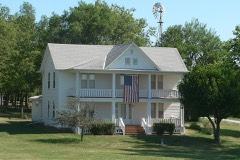 | Snoke Farmstead | 5.7 miles | 1998 |
| National Archives record | The nomination case file for reference 11000103 in Record Group 79. |
| Cass County | All 26 listed properties in this county. |