 Block
From the record
One of 26 National Register listings published here for Cass County · listed in 1980 · category: Building.
Sources: the case file at the National Archives · the National Register database, National Park Service
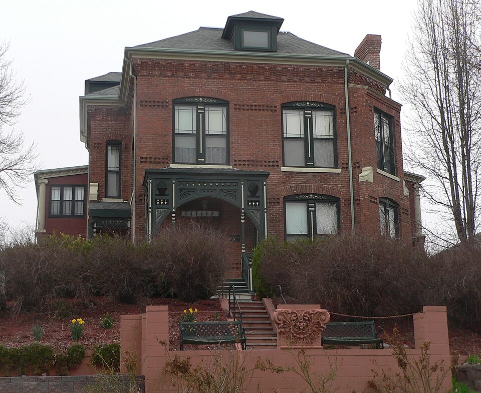
Listed on the National Register of Historic Places in 1980.
One of 26 National Register listings published here for Cass County · listed in 1980 · category: Building.
Sources: the case file at the National Archives · the National Register database, National Park Service
Regional context, not property-specific evidence. The federal wildfire occurrence database lists 103 fires within 5 miles of McLaughlin-Waugh-Dovey House between 2008 and 2020, burning about 652 acres in total. None started naturally. 1 was recorded as arson. Distance is straight-line from the map coordinates, so a fire counted here may appear on a neighbouring settlement's page as well.
| Reported cause | Fires |
|---|---|
| Debris and open burning | 41 |
| Missing data/not specified/undetermined | 40 |
| Equipment and vehicle use | 6 |
| Smoking | 5 |
| Fireworks | 3 |
| Power generation/transmission/distribution | 2 |
| Recreation and ceremony | 2 |
| Misuse of fire by a minor | 2 |
| Railroad operations and maintenance | 1 |
| Arson/incendiarism | 1 |
The most recent of them, most recent first, with the day each was reported and the service that recorded it.
| Date | Cause | Size | Reported by | Name on the report |
|---|---|---|---|---|
| 4 September 2017 | Debris and open burning | 1.0 acres | Nebraska Forest Service | not named |
| 4 September 2013 | Missing data/not specified/undetermined | under an acre | Nebraska Forest Service | not named |
| 14 September 2017 | Power generation/transmission/distribution | 1.0 acres | Nebraska Forest Service | not named |
| 1 September 2013 | Smoking | under an acre | Iowa Department of Natural Resources | not named |
| 27 August 2012 | Debris and open burning | under an acre | Nebraska Forest Service | not named |
| 24 August 2012 | Debris and open burning | under an acre | Nebraska Forest Service | not named |
| 4 July 2015 | Fireworks | under an acre | Nebraska Forest Service | not named |
| 4 July 2014 | Fireworks | under an acre | Nebraska Forest Service | not named |
Regional context, not property-specific evidence. The federal mineral resources record lists 1 working within 5 miles of McLaughlin-Waugh-Dovey House: 1 past producer. None of them still produces. What was taken out: Sand and Gravel, Construction. Distance is straight-line from the map coordinates, so a quarry counted here may appear on a neighbouring settlement's page as well.
| Where | Site | Commodity | Status | Recorded |
|---|---|---|---|---|
| Pacific Junction Pit | Sand and Gravel, Construction | Past Producer |
Regional context, not property-specific evidence. The National Weather Service names Plattsmouth, the town this property stands in, in 95 storm reports between 1995 and 2024: 34 thunderstorm wind, 30 hail, 21 flood, 4 heavy rain. The reports record 3 injuries. Each account below is quoted exactly as the forecast office filed it, from the NOAA Storm Events Database, and each date opens the federal record of that event.
| When | Event | Place named | Harm | What the report says |
|---|---|---|---|---|
| June 2017 | Thunderstorm Wind | Plattsmouth | 3 hurt | Substantial wind damage was reported in Plattsmouth. Trees down on most roads. |Power lines were blown down, with no power between Louisville, Plattsmouth, and Weeping Water. Maintenance building was destroyed. Several farmsteads on Highway 66 had buildings destroyed. There were 3 people injured in Plattsmouth. |
| July 1996 | Hail | Plattsmouth | $1,000,000 | no account filed |
| March 2010 | Flood | Plattsmouth | $625,000 | Melting snow and periods of rain brought a prolonged period of flooding along the Missouri River. The river stage at Plattsmouth remained about its 26 foot flood stage for around 9 days in mid to late March, cresting at a little over 29 feet around midnight on the 22nd. The flooding mainly affected agricultural lowlands, but several roads near the river flooded, including the road that led to Plattsmouth's public boat dock and water treatment plant. Plant workers had to use a small boat to reach the plant. Damage included silt/debris clean-up and gravel washed off of county roads, which was estimated to be between $250,000 and $1 million according to emergency management. |
| June 2011 | Flood | Plattsmouth | $250,000 | Flooding along the Missouri River gradually worsened during June as record releases from Gavins Point Dam brought widespread flooding along the river. The river at Plattsmouth started the month around 30 feet, flood stage is 26 feet. The river then gradually rose through June reaching a little over 36 feet by the end of the month. The river remained in major flood stage into July. The high water initially flooded marshy areas and farmland along the river along with a few roads and recreation areas, including a road to the Plattsmouth water treatment plant. By the middle of the month some businesses and homes began to flood and most of 210 dwellings around Lake Waconda in the area were evacuated. |
| September 1996 | Lightning | Plattsmouth | $200,000 | no account filed |
| July 1995 | Hail | Plattsmouth | $110,000 | A small section of Cass County received significant crop damage due to hail. Marble to golf ball-size hail completely destroyed 500 to 1,000 acres of corn and soybeans, and partially destroyed another 1,000 acres. The Buccaneer Bay golf course received $10,000 damage to its greens and there was considerable damage to area roofs. |
| June 2010 | Flood | Plattsmouth | $100,000 | Heavy rain over much of eastern Nebraska and western Iowa during most of June caused a prolonged period of flooding along the Missouri River, especially downstream of Omaha through Rulo. The flood damage was increased near the confluence of the Platte River where flood waters from the Platte added to the flow. In Plattsmouth the Missouri River crested a little over 33 feet in the late afternoon of June 22nd, flood stage is 26 feet. The river climbed above flood stage in the afternoon of June 11 and remained above flood stage into early July. Some roads on the east end of Plattsmouth were closed due to flood waters which also submerged the land around a waste-water treatment plant which prompted sandbagging. A recreation area in the region was also partially submerged in flood waters along with the Plattsmouth boat house. |
| June 2024 | Flood | Plattsmouth | $75,000 | Excessive rainfall across much of eastern South Dakota resulted in river flooding along the Missouri River at the end of June. Moderate flood stage was observed along the Missouri, with the river gauge in Plattsmouth cresting at 31.75 feet on 6/29. Flood stage for this river gauge is 26.0 feet. At 8:26 pm on the 23rd, emergency management reported the first instances of flooding showing several photos of lowland flooding in multiple spots along the river east of Plattsmouth. At 12:32 pm CDT on 6/25, Cass County emergency management sent photos of flooding at the Plattsmouth boat dock. Lowland flooding persisted into 6/26, with emergency management sending the office pictures of flooded fields from Sullivan Drive and Lake Waconda. At 5:56 PM on the 27th, emergency management reported flooding at the Plattsmouth sewer lift station on the south side of Main Street. |
| August 2011 | Flood | Plattsmouth | $50,000 | Flooding along the Missouri River in Cass county gradually worsened during June as record releases from Gavins Point Dam brought widespread flooding along the river. At Plattsmouth the Missouri River gradually rose through June reaching a little over 36 feet by the end of that month. Flood stage is 26 feet. The river remained in major flood stage into early July then slowly dropped into the moderate category by mid July and continued in that category through mid August before dropping by the end of the month to around 30 feet. However, minor flooding persisted through much of September. The high water flooded farmland along the river along with a few roads and recreation areas, including a road to the Plattsmouth water treatment plant. Some businesses and homes were also flooded, and most of the 210 dwellings around Lake Waconda in the area were evacuated. |
| September 2011 | Flood | Plattsmouth | $50,000 | Flooding along the Missouri River in Cass county which had gradually worsened during June and remained in a major or moderate flood category until late August, finally started letting up from late August into September as record releases from Gavins Point Dam were greatly reduced after mid August. At Plattsmouth the Missouri River reached a crest a little over 36 feet by the end of June, flood stage is 26 feet, remained at very high levels in July and August before dropping to around 30 feet by the first of September. Stepped decreases in reservoir releases allowed the river to finally fall below flood stage at Plattsmouth late in September. At its worst, the high water flooded farmland along with a few roads and recreation areas, including a road to the Plattsmouth water treatment plant. Some businesses and homes were also flooded, and most of the 210 dwellings around Lake Waconda in the area were evacuated. |
| July 2011 | Flood | Plattsmouth | $50,000 | Flooding along the Missouri River gradually worsened during June as record releases from Gavins Point Dam brought widespread flooding along the River. The river at Plattsmouth gradually rose through June reaching a little over 36 feet by the end of the month. The river remained in major flood stage into early July slowly dropped into the moderate category by the middle of the month. The high water flooded farmland along the river along with a few roads and recreation areas, including a road to the Plattsmouth water treatment plant. Some businesses and homes were also flooded, and most of the 210 dwellings around Lake Waconda in the area were evacuated. |
| July 1997 | Flash Flood | Plattsmouth | $12,000 | Thunderstorms produced nearly two inches of rain in a short time. This caused the side of an oil company building to collapse. |
| June 2014 | Flood | Plattsmouth | $10,000 | Several episodes of heavy rain caused the Missouri River to flood for an extended period downstream of it's confluence with the Platte River. At Plattsmouth the river crested around 30 feet during the morning of June 22, flood stage is 26 feet. The flooding impacted a few local roads and farmland near the river. |
| May 2011 | Flood | Plattsmouth | $10,000 | High releases from upstream reservoirs and periods of rain brought a prolonged flooding episode along the Missouri River. The river at Plattsmouth started the month a little above it's 26 foot flood stage, fell briefly below it from the 5th through the 11th, then steadily rose to a little over 30 feet by the end of the month. The flooding carried over into June. Although the high water mainly flooded marshy areas and farmland along the river, by the end of the month a few roads, recreational areas and cabins/houses were either flooded or threatened by flood waters. |
| April 2011 | Flood | Plattsmouth | $5,000 | Several episodes of heavy rain combined with snow melt and rain upstream and caused a prolonged high flow of the Missouri River. The river at Plattsmouth started climbing significantly on 4/19 and went a little over it's 26 foot flood stage late in the evening on 4/22 and remained close to or above flood stage through May. Although the high water mainly flooded marshy areas and farmland along the river, it also flooded a few roads and recreational areas by the river. |
| August 2010 | Flood | Plattsmouth | $5,000 | This flooding carried over from June and July when heavy rain over much of eastern Nebraska and western Iowa during those months causing a prolonged period of flooding along the Missouri River, especially downstream of Omaha through Rulo. Although the river at Plattsmouth dropped below flood stage on July 8th, it remained high all of July climbing back above flood stage in the middle of the month and again several times late in the month into August. In Plattsmouth, the Missouri River crested a little over 33 feet in the late afternoon of June 22nd, flood stage is 26 feet. A July crest of around 29.5 feet was observed on the first with a crest of around 29 feet in August was seen on the 4th. Some roads on the east end of Plattsmouth were closed due to flood waters which also submerged the land around a waste-water treatment plant which prompted sandbagging. A recreation area in the region was also partially submerged in flood waters. Most of the damage and more significant flooding was observed in June and July. |
| July 2010 | Flood | Plattsmouth | $5,000 | This flooding carried over from June when heavy rain over much of eastern Nebraska and western Iowa during that month and also in July caused a prolonged period of flooding along the Missouri River, especially downstream of Omaha through Rulo. Although the river at Plattsmouth dropped below flood stage on July 8th, it remained high all of July climbing back above flood stage in the middle of the month and again several times late in the month into August. The flood damage was increased near the confluence of the Platte River early in the month where flood waters from the Platte added to the flow. In Plattsmouth the Missouri River crested a little over 33 feet in the late afternoon of June 22nd, flood stage is 26 feet. The July crest was about 29.5 feet on the first. Some roads on the east end of Plattsmouth were closed due to flood waters which also submerged the land around a waste-water treatment plant which prompted sandbagging. A recreation area in the region was also partially submerged in flood waters. |
| May 1999 | Tornado (F0) | Plattsmouth | $5,000 | Some shingle and tree damage was caused near the Beaver Lake area before the tornado crossed the Missouri River near Pacific Junction. |
| May 2024 | Thunderstorm Wind | Plattsmouth | - | The Cass County Emergency Manager reported that the town of Plattsmouth was without power due to the line of severe thunderstorms that had moved through. |
| July 2024 | Flood | Plattsmouth | - | This is a continuation of river flooding from the end of June. River levels crested along this stretch of the Missouri at the end of June, hence flood waters were receding by this time. As such, the greatest impacts were felt in June (and discussed in the June entry for StormData). For the first part of July while flood waters continued to recede, continued impacts were felt in the form of residual flooding in low-lying areas of roads, trails, and riverfront properties. Damage estimates can be found in June StormData. |
| July 2024 | Thunderstorm Wind | Plattsmouth | - | A mesonet station recorded a 59 miles per hour wind gust. |
| June 2024 | Thunderstorm Wind | Plattsmouth | - | An off duty National Weather Service employee recorded a 60 miles per hour wind gust. |
| June 2024 | Hail | Plattsmouth | - | Emergency Management reported golf ball sized hail. |
| October 2024 | Hail | Plattsmouth | - | A trained spotter reported dime to quarter sized hail in Plattsmouth. |
| May 2023 | Hail | Plattsmouth | - | Public reported 1-inch hail via mPing. |
| May 2023 | Hail | Plattsmouth | - | Emergency Manager reported 1.75-inch hail. |
| May 2023 | Hail | Plattsmouth | - | Public reported 1-inch hail via mPing. |
| April 2022 | Hail | Plattsmouth | - | Public reported 1 inch hail via social media. |
| August 2021 | Hail | Plattsmouth | - | Report from mping of 1-inch hail. |
| July 2020 | Thunderstorm Wind | Plattsmouth | - | Public reported 6+ inch tree limbs damaged. |
| March 2019 | Flood | Plattsmouth | - | Evacuation of residents by boat of Morehead Island when all roads became impassable. Railroad tracks in the area are also being impacted. |
| September 2018 | Heavy Rain | Plattsmouth | - | The Emergency Manager reported 1.5 inches of rain was measured in 45 minutes. |
| September 2018 | Heavy Rain | Plattsmouth | - | A spotter reported 2.54 inches of rain. |
| October 2017 | Heavy Rain | Plattsmouth | - | This is a 24 hour rainfall report ending at 7am. |
| October 2017 | Heavy Rain | Plattsmouth | - | This is a heavy rainfall report. |
| April 2016 | Thunderstorm Wind | Plattsmouth | - | The broadcast media reported winds to near 60 mph. |
| May 2016 | Flood | Plattsmouth | - | Minor flooding was observed to agricultural land to the west of Dock Road. |
| May 2016 | Flood | Plattsmouth | - | Generally minor flooding was observed along the river with a crest of 27.10 feet on the 12th, but some parkings lots, a boat ramp, and a private camping area were also reported to have flooded. |
| July 2015 | Thunderstorm Wind | Plattsmouth | - | Spotters reported tree limbs 8 to 10 inches in diameter were downed in the city of Plattsmouth. |
| June 2014 | Thunderstorm Wind | Plattsmouth | - | The gust was estimated by the public. |
| May 2013 | Hail | Plattsmouth | - | The hail was accompanied by thunderstorm winds which caused tree damage in town. |
| May 2013 | Thunderstorm Wind | Plattsmouth | - | Thunderstorm wind gusts estimated at 65 to 70 mph downed trees in the Plattsmouth area, some of which caused vehicle and house damage. The winds were accompanied by hail that reached half dollar-size. |
| October 2013 | Thunderstorm Wind | Plattsmouth | - | Law enforcement and media reports indicated that numerous large tree limbs and power poles were downed from the strong winds associated with this line of thunderstorms. |
| May 2013 | Thunderstorm Wind | Plattsmouth | - | This estimated wind gust was reported at the Plattsmouth Country Club. |
| March 2012 | Hail | Plattsmouth | - | The hailstones were mostly 1/2-3/4 inches in diameter but a stone or two reached 1 to 1.5 inches in the Plattsmouth area. |
| March 2012 | Hail | Plattsmouth | - | Hail up to half dollar-size fell for around 10 minutes in and just south of Plattsmouth. |
| August 2012 | Thunderstorm Wind | Plattsmouth | - | Thunderstorm wind gusts of 60 mph were measured by the Awos at Plattsmouth. |
| July 2011 | Thunderstorm Wind | Plattsmouth | - | Tree damage was observed with thunderstorm wind gusts that were in excess of 60 mph. |
| August 2010 | Thunderstorm Wind | Plattsmouth | - | Thunderstorm wind gusts estimated at 55 to 60 mph downed a 4 inch in diameter tree limb. |
| July 2010 | Thunderstorm Wind | Plattsmouth | - | A thunderstorm wind gust of 62 mph was measured by Awos at the Plattsmouth airport. |
| May 2008 | Thunderstorm Wind | Plattsmouth | - | A thunderstorm gust of 59 mph was measured at the Plattsmouth airport. |
| May 2008 | Flood | Plattsmouth | - | Heavy rainfall during the evening of May 29th culminated nearly a week of scattered heavy rain producing thunderstorms that occurred along the Missouri River basin. The heavy rains caused the Missouri River to flood from near its confluence with the Platte River near Plattsmouth downstream through Rulo which is in extreme southeast Richardson county. The river stage at Plattsmouth reached a 30 foot crest around 10am CDT on May 31st, flood stage is 26 feet. This flooding event lasted into the early morning hours of June 2nd. The flooding affected mainly agricultural lowlands. |
| June 2008 | Thunderstorm Wind | Plattsmouth | - | Thunderstorm wind gusts estimated at over 60 mph blew a tree onto a mobile home. The winds could have been the rear flank downdraft winds from a supercell thunderstorm that produced a tornado a little earlier near Louisville. |
| June 2008 | Flood | Plattsmouth | - | This flooding event carried over from May when heavy rain producing thunderstorms during the last week of May occurred along the Missouri River basin. The heavy rains caused the Missouri River to flood from near its confluence with the Platte River near Plattsmouth downstream through Rulo, which is in extreme southeast Richardson county. The river stage at Plattsmouth reached a 30 foot crest around 10am CDT on May 31st, flood stage is 26 feet. This flooding event lasted into the early morning hours of June 2nd. The flooding affected mainly agricultural lowlands. |
| June 2008 | Flood | Plattsmouth | - | Heavy rain over sections of the Missouri River basin on June 4th and 5th caused another crest to occur along the Missouri River from around its confluence with the Platte River near Plattsmouth, downstream to near Nebraska City. From there the river never really did fall below flood stage from late May until the third week of June. Flooding along the Missouri River in Cass county from this crest began during the mid afternoon hours of June 5th. Although the river briefly dropped below flood stage during the overnight hours of June 7th, additional heavy rains on the 7th and early on the 8th pushed the river back above flood stage. The river near Plattsmouth eventually reached a crest of around 31 feet at 415pm CDT on June 12th. Flood stage is 26 feet. The river finally dropped below flood stage at Plattsmouth during the afternoon hours of June 14th. The flooding affected agricultural lowlands and also closed a few county roads in the area. |
| July 2008 | Thunderstorm Wind | Plattsmouth | - | Thunderstorm wind gusts estimated at over 60 mph downed a few trees and numerous tree limbs in the Plattsmouth area. The fallen trees caused scattered power outages. |
| March 2007 | Hail | Plattsmouth | - | Hail up to 1 inch in diameter was reported by the fire department near Plattsmouth. |
| February 2007 | Flood | Plattsmouth | - | An ice jam and rising water due to snow melt on the Platte River caused flooding near the Horseshoe Lake Sub division in northern Cass county. |
| May 2007 | Flood | Plattsmouth | - | Heavy rainfall over the weekend of May 4th through the 6th caused a prolonged flood along the Missouri River in southeast Nebraska. At Plattsmouth the Missouri River crested just over 30 feet for around 6 hours during the early morning hours of May 7th. Flood stage at Plattsmouth is 26 feet. The river at Plattsmouth first crossed flood stage around 545 am CDT on the 6th and didn't drop below flood stage until a little after midnight CDT on the 9th. The flooding affected mainly agricultural lowlands, but some county roads were closed due to the flood waters as well as a local marina. |
| August 2007 | Thunderstorm Wind | Plattsmouth | - | Thunderstorm wind gusts estimated at 60 mph downed large tree branches and power lines in town. |
No historic map-sheet match is published for this property yet. That does not mean no map exists. This record needs a coordinate-quality review before it can be joined to a sheet boundary. Browse the county's mapped places while that work is pending.
Other National Register properties close enough to walk or drive between, ordered by distance from this one. Both positions come from the same geocoding pass that matched these properties to their map sheets.
| Photograph | Property | Distance | Listed |
|---|---|---|---|
 | Velosco V. Leonard House | under 500 feet | 2018 |
 | Paul Gering House | 0.1 miles | 2006 |
 | George E. Dovey House | 0.1 miles | 2018 |
 | Capt. John O'Rourke House | 0.1 miles | 2006 |
 | Plattsmouth Main Street Historic District | 0.1 miles | 1985 |
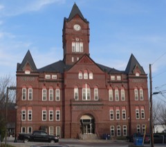 | Cass County Courthouse | 0.1 miles | 1990 |
| National Archives record | The nomination case file for reference 80002443 in Record Group 79. |
| Cass County | All 26 listed properties in this county. |