Listed on the National Register of Historic Places in 1984.
From the record
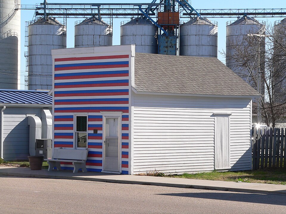
“The Cahow Barber Shop is located in Chapman, Nebraska. It is a false-front building of frame construction with a gable roof and linteled door and window hoods, built in 1889.”
Wikipedia article Cahow Barber Shop, CC BY-SA 4.0.
One of 8 National Register listings published here for Merrick County · listed in 1984 · category: Building.
National Register reference number.84002493- the number the National Park Service assigned this property when it was listed, and the key its nomination file is catalogued under at the National Archives.
When the Union Pacific, in 1866, staked out its towns eleven miles apart along its road, the future station of Chapman had least reason of all the stations along th.e road to claim for itself the name of "town." Shoemaker's Point was abandoned, and yet the truth is hardly told when we say that it was abandoned that the village of Chapman might come into existence. From Central City to Grand Island was practically a townless tract, and even the need of a town between them was at that time unfelt.
But the deciee of the railroad, that there should be a station here, could not long be disobeyed, and in 1871 the first business building of Chapman was erected by Messrs. L. Reed and C. A. Leake and occu¬ pied by them for a general trading store. The first real store was opened in 1873 by Mr. J. I. Walker and sold by him to Mr. W. H. Morris in 1877. The real importance of the town dates from 1878, when the Chapman bridge across the Platte was completed, opening up the trade of the northern part of Hamilton County for the benefit of the new town. During this year the town attained to almost its present size, and would probably be today a fair rival of tb#* county seat had not the coming of the Burlington branch into Hamilton County a short time after taken away a large portion of the new territory after which it was reaching.
Regional context, not property-specific
evidence. The
federal wildfire occurrence database
lists 32 fires within 5 miles of Cahow Barber Shop
between 2001 and 2018, burning about 52 acres in total. 1 started naturally. 1 was recorded as arson.
Distance is straight-line from the map coordinates, so a fire counted
here may appear on a neighbouring settlement's page as well.
Reported cause
Fires
Railroad operations and maintenance
11
Debris and open burning
8
Equipment and vehicle use
5
Missing data/not specified/undetermined
5
Arson/incendiarism
1
Smoking
1
Natural
1
The most recent of
them, most recent first, with the day each was reported and the service
that recorded it.
Regional context, not property-specific
evidence. The National Weather Service names
Chapman, the town this property stands in, in 64 storm reports between 1994 and 2022: 42 hail, 17 thunderstorm wind, 2 tornado, 2 flood.
No death or injury is recorded in these reports. Each account below is quoted exactly as the forecast office
filed it, from the NOAA Storm Events Database, and each date
opens the federal record of that event.
Emergency management reported several pivots were flipped over and mangled north of Chapman. At a convenience store in Chapman, a metal light pole was blown down, and a large metal ice chest was moved away from the main building into the parking lot.
This EF1 tornado tracked nearly 10 miles through rural portions of far east central Hall and far southwestern Merrick counties during the very early morning hours of Monday, July 4th. The maximum wind speed was estimated to be 110 MPH, based on the combination of damage to trees, some buildings and homes, and power poles. The tornado was estimated to be 200 yards wide at its widest point.||This tornado first touched down in a rural area four miles south of downtown Grand Island and quickly gained strength. It entered Merrick County around 12:56 a.m. CDT near the intersection of Gunbarrel and Stolley Park Roads, persisting for nearly six more miles before lifting at 1:10 a.m. CDT approximately five miles southwest of Chapman (near the intersection of 5th and D Roads). Along its total path, it damaged over a half-dozen homes, including blown out windows, shingle and siding damage, and at least one home had part of its roof decking torn off (fortunately no injuries were reported). Other outbuildings and grain bins were damaged or destroyed, including a barn in Merrick County that was over 100 years old. Several power poles were snapped, along with trees and damage to crops. The damage pattern evident in corn fields had a distinct herringbone pattern...consistent with a tornadic wind field. ||This tornado formed in a trailing area of stratiform rainfall not usually conducive for tornadic development. The combination of a very moist, unstable airmass and very favorable wind shear for the time of day were key in the formation of the low-topped supercell which spawned the tornado.
A pickup was swept off of worms road in western Merrick County. Most of the residents in Archer woke to significant flooding around 0300CST June 8th and began sandbagging. Cars were floating in Archer. Numerous roads were washed out across western Merrick County.
No historic map-sheet match is published
for this property yet. That does not mean no map exists. This record needs
a coordinate-quality review before it can be joined to a sheet boundary.
Browse the county's mapped places while that work is
pending.
Listed places nearby
1 within 8 miles
Other National Register properties close
enough to walk or drive between, ordered by distance from this one. Both
positions come from the same geocoding pass that matched these properties
to their map sheets.
Listing record. National Park Service National Register of Historic Places, listed-properties dataset, current to 2026-05-22.
Map join. Address geocoded through the United States Census geocoder, then tested against the published boundary of every sheet in the USGS Historical Topographic Map Collection.
How this page is made. Listing fields come from federal records; map-sheet coverage is a labelled coordinate-to-boundary calculation, not a source-field claim.
Wildfire. Short, Karen C. 2022. Spatial wildfire occurrence data for the United States, 1992-2020 [FPA_FOD_20221014]. 6th Edition. Fort Collins, CO: Forest Service Research Data Archive. https://doi.org/10.2737/RDS-2013-0009.6 Collected with United States Government funding and usable without additional permissions or fees.
Storms. NOAA National Centers for Environmental Information, Storm Events Database https://www.ncei.noaa.gov/stormevents/ A work of the United States government, no copyright under 17 U.S.C. 105. Narratives are quoted verbatim from the National Weather Service report and are not edited or summarised.
 Block