

BlockBefore
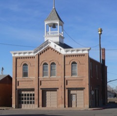
Photograph of Schneider's Opera House
Photograph by Ammodramus, CC0 1.0. Via Wikimedia Commons.

Scheider's Opera House

Listed on the National Register of Historic Places in 1988.

From the record

“The Schneider Opera House is a historic building in Snyder, Nebraska. It was built as a two-part commercial block building in 1900 on land formerly owned by Conrad Schneider, Snyder's founder.”

Wikipedia article Schneider's Opera House, CC BY-SA 4.0.

One of 23 National Register listings published here for Dodge County · listed in 1988 · category: Building.

Sources: the Wikipedia article · the case file at the National Archives · the National Register database, National Park Service · the Wikipedia article

The listing

  • What is counted as historic. The nomination lists 1 building as contributing to the listing.
  • Address. 104 Ash, Snyder, 68057
  • When was it listed? September 1988
  • Category. building
  • Also known as. Opera House Buildings in Nebraska 1867-1917 MPS
  • Township. Pebble township
  • National Register reference number. 88000939 - the number the National Park Service assigned this property when it was listed, and the key its nomination file is catalogued under at the National Archives.

Fires near this property

21 since 2002

Regional context, not property-specific evidence. The federal wildfire occurrence database lists 21 fires within 5 miles of Scheider's Opera House between 2002 and 2018, burning about 81 acres in total. None started naturally. 1 was recorded as arson. Distance is straight-line from the map coordinates, so a fire counted here may appear on a neighbouring settlement's page as well.

Reported cause Fires
Equipment and vehicle use9
Debris and open burning8
Smoking2
Power generation/transmission/distribution1
Arson/incendiarism1

The most recent of them, most recent first, with the day each was reported and the service that recorded it.

DateCause SizeReported by Name on the report
5 September 2009Equipment and vehicle useunder an acreNebraska Forest Servicenot named
29 September 2011Equipment and vehicle use5.0 acresNebraska Forest Servicenot named
11 September 2008Power generation/transmission/distributionunder an acreNebraska Forest Servicenot named
7 July 2007Debris and open burningunder an acreNebraska Forest Servicenot named
5 May 2003Smoking1.5 acresNebraska Forest Servicenot named
5 April 2008Debris and open burningunder an acreNebraska Forest Servicenot named
5 April 2008Debris and open burning20 acresNebraska Forest Servicenot named
3 April 2005Debris and open burning10 acresNebraska Forest Servicenot named

Every fire recorded in Dodge County

Storms near this property

40 since 1996

Regional context, not property-specific evidence. The National Weather Service names Snyder, the town this property stands in, in 40 storm reports between 1996 and 2025: 19 hail, 13 thunderstorm wind, 2 flash flood, 2 tornado. No death or injury is recorded in these reports. Each account below is quoted exactly as the forecast office filed it, from the NOAA Storm Events Database, and each date opens the federal record of that event.

WhenEvent Place namedHarm What the report says
June 1998Tornado (F1)Snyder$500,000Several outbuildings and grain bins destroyed. A house was destroyed. A machine shed destroyed. A chimney was blown off the back porch of a house. Hog barn destroyed.
June 2010FloodSnyder$100,000Several periods of heavy rain fell across the Pebble Creek basin from June 8th through the 14th which produced a prolonged period of high water and flooding along Pebble Creek near and west of Scribner. The high water flooded and closed sections of Highways 275 and 91 near town as well as county roads and farmland in the area. Pebble Creek near Scribner crested at just over 23 feet during the late afternoon of June 10th, flood stage is 18 feet. The creek near Scribner was above flood stage most of the period from around noon on the 10th until late in the afternoon on June 12th, although a few times during this stretch the creek dropped below flood stage.
June 1996Thunderstorm WindSnyder$5,000no account filed
September 2025HailSnyder-Trained spotter report of hail estimated at 1 inch in diameter.
May 2024Tornado (EF0)Snyder-A brief tornado developed just south of Prenzlow Meat Factor, damaging outbuilding and both snapping and uprooting pine trees. The tornado continued east, flipping and mangling a center pivot before dissipating. The peak winds in this tornado were estimated to be 85 miles per hour. The maximum width of the tornado was measured to be 75 yards with the average width estimated to be 30 yards.
May 2024Funnel CloudSnyder-The Snyder Fire Department reported a funnel cloud that passed over the top of the town.
May 2024Thunderstorm WindSnyder-An intense corridor of straight-line wind damage occurred in the town of Snyder just before 2 AM on the morning of 5/24. A damage survey in the town reveals numerous large trees snapped and uprooted through the town. Several power poles were also snapped on the east side of town. An EF-0 tornado developed just east of town embedded in the broader swath of straight-line wind damage.
April 2022HailSnyder-Public reported 1.5 inch hail via social media.
April 2022Thunderstorm WindSnyder-Personal weather station measured a peak wind gust of 72 mph.
August 2021HailSnyder-Public report from mping of 1-inch hail.
August 2020HailSnyder-Law enforcement reported 1 inch hail.
June 2018Funnel CloudSnyder-A distinct brief funnel cloud was sighted near Snyder.
May 2010Thunderstorm WindSnyder-Thunderstorm winds estimated at close to 60 mph downed a large tree branch on the north side of town.
May 2008FloodSnyder-Heavy rainfall during the evening of May 29th caused Pebble Creek to flood from its mouth with the Elkhorn River near Scribner upstream to north of Snyder and then into Cuming county. Pebble Creek at Scribner reached 24.7 feet around 6am CDT on May 30th, flood stage is 18 feet. The creek at Scribner was above flood stage for about 16 hours from late on the 29th until mid afternoon on the 30th. The flooding closed county roads in the area and also flooded farmland. The crest at Scribner was one of the highest on record. Flooding was also observed along a tributary of Pebble Creek in the Dodge area closing a highway spur into town.
August 2007Thunderstorm WindSnyder-Thunderstorm winds estimated at 60 to 70 mph flattened corn near Snyder.
July 2007Thunderstorm WindSnyder-Thunderstorm winds estimated at 60 mph downed several trees around the Snyder area causing some damage to a few buildings and other structures.
May 2005HailSnyder-The hail covered the ground.
July 2005Thunderstorm WindSnyder-Thunderstorm wind gusts estimated at 60 mph broke some large tree branches near Snyder.
July 2003Thunderstorm WindSnyder-Thunderstorm wind gusts were estimated at 65 mph by emergency management.
July 2003Thunderstorm WindSnyder-Thunderstorm wind gusts blew the roof off of a grain bin and downed several trees around Snyder.
April 2002Thunderstorm WindSnyder-From the same storm complex that produced the wind damage near Howells in Colfax county. These thunderstorm wind gusts were estimated by the Emergency Manager of Dodge county.
May 2000Thunderstorm WindSnyder-Small trees were damaged by thunderstorm wind gusts.
June 1998Thunderstorm WindSnyder-One home lost a roof. Grain bins were blown over.
July 1997Flash FloodSnyder-Rainfall of 2 to 3 inches in a short time flooded many county roads and forced the Maple Creek out of its banks.
July 2008HailSnyder-no account filed
March 2007HailSnyder-no account filed
June 2007HailSnyder-no account filed
March 2006HailSnyder-no account filed
May 2003HailSnyder-no account filed
May 2001HailSnyder-no account filed
June 1998HailSnyder-no account filed
June 1997Flash FloodSnyder-no account filed
June 1997HailSnyder-no account filed
June 1996HailSnyder-no account filed
June 1996Thunderstorm WindSnyder-no account filed
June 1996HailSnyder-no account filed

Every storm recorded in Dodge County

Map coverage status

No historic map-sheet match is published for this property yet. That does not mean no map exists. This record needs a coordinate-quality review before it can be joined to a sheet boundary. Browse the county's mapped places while that work is pending.

Listed places nearby

2 within 8 miles

Other National Register properties close enough to walk or drive between, ordered by distance from this one. Both positions come from the same geocoding pass that matched these properties to their map sheets.

Photograph PropertyDistance Listed
Scribner Town Hall6.7 miles2010
Harder Hotel6.8 miles1989

Sources for this property

National Archives recordThe nomination case file for reference 88000939 in Record Group 79.
Wikipedia articleCommunity-written account of this property, licensed CC BY-SA.
Dodge CountyAll 23 listed properties in this county.

Provenance

  • Listing record. National Park Service National Register of Historic Places, listed-properties dataset, current to 2026-05-22.
  • Map join. Address geocoded through the United States Census geocoder, then tested against the published boundary of every sheet in the USGS Historical Topographic Map Collection.
  • How this page is made. Listing fields come from federal records; map-sheet coverage is a labelled coordinate-to-boundary calculation, not a source-field claim.
  • Wildfire. Short, Karen C. 2022. Spatial wildfire occurrence data for the United States, 1992-2020 [FPA_FOD_20221014]. 6th Edition. Fort Collins, CO: Forest Service Research Data Archive. https://doi.org/10.2737/RDS-2013-0009.6 Collected with United States Government funding and usable without additional permissions or fees.
  • Storms. NOAA National Centers for Environmental Information, Storm Events Database https://www.ncei.noaa.gov/stormevents/ A work of the United States government, no copyright under 17 U.S.C. 105. Narratives are quoted verbatim from the National Weather Service report and are not edited or summarised.