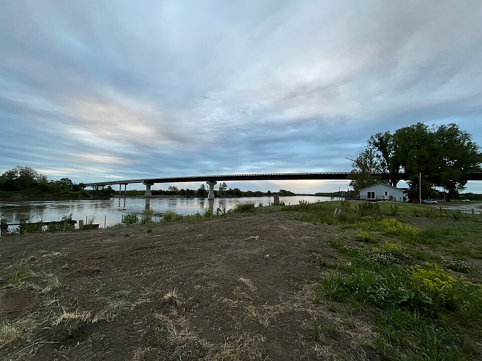
Listed on the National Register of Historic Places.
From the record
“The Rulo Bridge is a bridge that carries U.S. Route 159 over the Missouri River between Rulo, Nebraska and Minton Township, Missouri west of Big Lake.”
Wikipedia article Rulo Bridge, CC BY-SA 4.0.
One of 11 National Register listings published here for Richardson County · category: Structure.
National Register reference number.92000718- the number the National Park Service assigned this property when it was listed, and the key its nomination file is catalogued under at the National Archives.
Rulo precinct occupies die southeast corner and takes its name from the city of Rulo. The town was founded by Charles Rouleau, a bYenchman, who settled on the site of the town in 1855. The town is located on the Missouri river alx)ut two miles north of the Great Nemaha, and lies on what was l(irmerl\- known as the Half-Breed tract: consequently, the town and the land surrciunding it were allotted to and for a long time held by the halfjjreed Indians and white men who bad married into the Lo family.
For some years this element seriously retarded the progress ant! growth of this section of our county, but they disappeared before the tide of immigration that was attracted to this \icinity by its many natural advantages. The town of Rulo contained several hundred (perhaps seven or eight hundred) people prior to the coming of the railroad in 1871 and thereafter rapidly improved. In the year 1870, just prior to the coming of the railroad, which was built in from the south on this side of the river, this point handled more than one hundred thousand bushels of corn. A steam corn sheller was used for shelling the corn and the grain merchants there had much to complain of in regard to transportation facilities. One line of steamers had a monopoly upon the entire carrying trade on the river and practiced extortion in the way of high freight rates and, like the later and greater railroad monopoly, were as much displeasing to the shipper, as they carried the grain when they pleased, witliout reference to the convenience or interest of the shippers. This condition caused the shippers to pray for the speedy arri\al of the "iron horse," which forever (or at least to the present time), has put the boats out of business. They felt that the first snort of the iron horse coming from the south or east, along the valley of the Missouri, would spoil the nice little thing so long enjoyed by the steamboat men exclusively.
Regional context, not property-specific
evidence. The
federal wildfire occurrence database
lists 6 fires within 5 miles of Rulo Bridge
between 2016 and 2020, burning about 116 acres in total. None started naturally. None was recorded as arson.
Distance is straight-line from the map coordinates, so a fire counted
here may appear on a neighbouring settlement's page as well.
Reported cause
Fires
Debris and open burning
5
Equipment and vehicle use
1
The most recent of
them, most recent first, with the day each was reported and the service
that recorded it.
Regional context, not property-specific
evidence. The National Weather Service names
Rulo, the town this property stands in, in 27 storm reports between 1999 and 2024: 11 flood, 9 hail, 6 thunderstorm wind, 1 tornado.
No death or injury is recorded in these reports. Each account below is quoted exactly as the forecast office
filed it, from the NOAA Storm Events Database, and each date
opens the federal record of that event.
This was the second, and more significant flood of the Missouri River near Rulo in the month of June. The river crested at 21.47 ft, or 5.47 feet above flood stage. In addition to significant agricultural low-land flooding, some cabins along the river also flooded.
The Missouri River rose above flood stage during the afternoon of the 10th, and crested during the early morning hours on the 11th, before falling below flood stage on the afternoon of the 12th. The flooding was minor and confined to low-lying areas along the river.
Heavy rainfall at the end of September caused the Missouri River to go into flood. The river rose above flood stage in the afternoon on the 1st, crested on the afternoon of the 2nd, and fell below flood stage on the evening of the 3rd. The river flooding was minor and mainly confined to low-lying areas along the river.
Report received of a tornado touchdown a mile to the south-southwest of Rulo, Nebraska over NAWAS. No damage was observed after the fact, so a rating could not be assigned.
Minor flooding was observed along the Missouri River near Rulo. The river rose above flood stage at the end of April, but the flooding continued into early May when the crest was observed.
A prolonged period of flooding was observed along the Missouri River near the city of Rulo. The river crested twice during the period, once on the 2rd at 19.79 feet, and again in moderate flood on the 12th at 21 feet. This created an extended period of lowland agricultural flooding along the river. There were also several cabins that flooded along the river.
Heavy rain events on the 20th into the 21st created minor flooding on the Missouri River. The river crested 0.54 feet above flood stage at Rulo in southeast Nebraska.
Minor flooding was observed along the Missouri River near Rulo. The river crested 3.34 feet above flood stage. The flooding was confined to mainly low areas near the river channel.
Heavy rainfall over parts of southeast Nebraska on the 6th and 7th of May resulting in minor flooding along the Missouri River near Rulo. The river crested at 17.30 feet, or .3 feet above flood state during the early morning on the 9th of May. The flooding was confined to low-lying areas along the river.
Heavy rainfall over a two-day period in mid December brought the Missouri River to rise above flood stage. The crest reached 20.53 feet in the early morning hours of December 16th. This was 3.53 feet above flood stage. Flooding was confined to low agricultural areas along the river.
The Missouri River at Rulo went above flood stage late in the morning of May 28th, crested around 23.5 feet late in the evening of the 30th and eventually fell below flood stage early in the morning of June 2nd. Although the river mostly flooded agricultural lowlands, several cabins and possibly a business in the area either experienced minor flooding or were threatened by the flooding.
No historic map-sheet match is published
for this property yet. That does not mean no map exists. This record needs
a coordinate-quality review before it can be joined to a sheet boundary.
Browse the county's mapped places while that work is
pending.
Listing record. National Park Service National Register of Historic Places, listed-properties dataset, current to 2026-05-22.
Map join. Address geocoded through the United States Census geocoder, then tested against the published boundary of every sheet in the USGS Historical Topographic Map Collection.
How this page is made. Listing fields come from federal records; map-sheet coverage is a labelled coordinate-to-boundary calculation, not a source-field claim.
Wildfire. Short, Karen C. 2022. Spatial wildfire occurrence data for the United States, 1992-2020 [FPA_FOD_20221014]. 6th Edition. Fort Collins, CO: Forest Service Research Data Archive. https://doi.org/10.2737/RDS-2013-0009.6 Collected with United States Government funding and usable without additional permissions or fees.
Storms. NOAA National Centers for Environmental Information, Storm Events Database https://www.ncei.noaa.gov/stormevents/ A work of the United States government, no copyright under 17 U.S.C. 105. Narratives are quoted verbatim from the National Weather Service report and are not edited or summarised.
 Block