BlockBefore
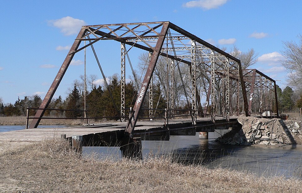
Photograph of Sargent Bridge
Photograph by Ammodramus, Public domain. Via Wikimedia Commons.

Sargent Bridge

Listed on the National Register of Historic Places in 1992.

From the record

“Sargent Bridge was a Pratt through truss steel bridge that spanned the Middle Loup River near Sargent, Nebraska. In 1992, it was listed in the National Register of Historic Places, as one of the few remaining steel truss bridges constructed in Nebraska during the early 20th century.”

Wikipedia article Sargent Bridge, CC BY-SA 4.0.

One of 14 National Register listings published here for Custer County · listed in 1992 · category: Structure.

Sources: the Wikipedia article · the case file at the National Archives · the National Register database, National Park Service

The listing

  • Listing status. The Park Service records this property as Removed.
  • What is counted as historic. The nomination lists 1 structure as contributing to the listing.
  • Address. Dawson St. over the Middle Loup R., 1 mi. south of Sargent, Sargent, 68874
  • When was it listed? June 1992
  • Category. structure
  • Also known as. Highway Bridges in Nebraska MPS
  • Township. Sargent township
  • National Register reference number. 92000740 - the number the National Park Service assigned this property when it was listed, and the key its nomination file is catalogued under at the National Archives.

The ground it stands on

9,166 words

The chapter on Sargent Township in History of Custer County, Nebraska; a Narrative of the Past, with Special Emphasis Upon the Pioneer Period of the County's History, Its Social, Commercial, Educational, Religous, and Civic Developement from the Early Days to the Present Time, published 1919 names Sargent. This is what it says, exactly as the scans read.

Sargent, a hustling village of over 800 inhabitants, is situated in the northeastern part of Custer count)', in the midst of a fine agricultural and stock-raising district. It is located on the north side of the Middle Loup river, about one mile from that stream. Sargent is one of the oldest towns in the county, having been laid out in 1883. The first bank in the county is located here. The first building erected was the general store of J. K. Spacht. in the summer of 1883, and the location was the middle of a field of wheat. The town grew rapidly and was particularly lively in the summer of 1888, when the B. & AI. Railroad grade was built, and it was expected that the cars would be running into the town that fall. Owing to a big strike on the system, the road was not completed at that time. The drouth years of the early '90s caused the town to dwindle down to a mere shadow of its former proportions. In the fall of 1899, however, the railroad was built from Arcadia to Sargent, making the latter the terminus, and since that time the town has had a very substantial growth. The Independent Telephone Company, of Broken Bow, extended its line to Sargent in the fall of 1900. The same fall was erected a fine, two-storv frame school building, which now houses one of the best schools in the county, under the charge of three teachers. Sargent has two churches, the Congregational and the ]\Iethodist. It has several fine business blocks, two newspapers, two banks, two grain elevators, and a creamery, with other lines of business well represented. Following is a complete business directory of the town, March 8, 1901 :

Passage source: History of Custer County, Nebraska; a Narrative of the Past, with Special Emphasis Upon the Pioneer Period of the County's History, Its Social, Commercial, Educational, Religous, and Civic Developement from the Early Days to the Present Time, published 1919.

Machine-read from a century-old scan, so expect the errors a machine makes: misspelled names, dropped words, stray characters.

Read the whole chapter on Sargent Township - 9,166 words on its settlement, mills, schools and churches.

Fires near this property

10 since 2007

Regional context, not property-specific evidence. The federal wildfire occurrence database lists 10 fires within 5 miles of Sargent Bridge between 2007 and 2019, burning about 238 acres in total. None started naturally. 1 was recorded as arson. Distance is straight-line from the map coordinates, so a fire counted here may appear on a neighbouring settlement's page as well.

Reported cause Fires
Debris and open burning8
Smoking1
Arson/incendiarism1

The most recent of them, most recent first, with the day each was reported and the service that recorded it.

DateCause SizeReported by Name on the report
8 March 2018Debris and open burning50 acresNebraska Forest Servicenot named
31 March 2018Debris and open burning45 acresNebraska Forest Servicenot named
31 March 2018Debris and open burning7.0 acresNebraska Forest Servicenot named
27 March 2019Arson/incendiarism15 acresNebraska Forest Servicenot named
15 March 2018Debris and open burning40 acresNebraska Forest Servicenot named
14 March 2018Debris and open burning10 acresNebraska Forest Servicenot named
14 March 2018Debris and open burning40 acresNebraska Forest Servicenot named
5 February 2013Smoking6.0 acresNebraska Forest Servicenot named

Every fire recorded in Custer County

Storms near this property

60 of 79 shown

Regional context, not property-specific evidence. The National Weather Service names Sargent, the town this property stands in, in 79 storm reports between 1995 and 2025: 52 hail, 9 thunderstorm wind, 7 tornado, 7 flash flood. No death or injury is recorded in these reports. Each account below is quoted exactly as the forecast office filed it, from the NOAA Storm Events Database, and each date opens the federal record of that event.

WhenEvent Place namedHarm What the report says
March 2019FloodSargent$1,000,000Historical bridge 1 mile south of Sargent destroyed by Ice flows along the Middle Loup River.
March 2019FloodSargent$500,000Custer county emergency management reports extensive flooding in Sargent.
October 2000Tornado (F1)Sargent$250,000The tornado touched down 2 miles west of Sargent with damage to a farm building and center pivot irrigation system. The tornado moved north northeast with several power poles broken off and minor damage produced at a farm 2 miles northwest of Sargent. The tornado then moved across open country until destroying a communication tower and several power poles 5 miles north of Sargent. A farm building was then damaged 6 miles north of Sargent before the tornado moved into southeast Loup county.
September 2010Flash FloodSargent$75,000Heavy rainfall led to the failure of a 50 foot dam near 3 miles southwest of Broken Bow on highway 21. The flood water moved down toward the southwest edge of town to impact the Callaway road one mile west of town and highway 21 as water flowed across the roads. Rainfall gage estimates around town measured up to 4.5 inches with several streets and homes in town flooded as well due to heavy rain.
July 2000HailSargent$40,000no account filed
August 2006Thunderstorm WindSargent$25,000Thunderstorm wind gusts overturned a portion of a center pivot irrigation system.
August 2007HailSargent$25,000no account filed
August 2017Thunderstorm WindSargent$20,000A fifth wheel trailer was blown over into a truck and an outbuilding. Winds were estimated at 85 MPH based on radar and the nature of the damage.
June 2025Flash FloodSargent$15,000Water over multiple county roads in far northeastern Custer County.
May 2007HailSargent$6,000Several vehicles received damage.
July 2001HailSargent$6,000no account filed
June 2014HailSargent$5,000no account filed
July 2001HailSargent$5,000no account filed
June 2002HailSargent$4,000no account filed
July 2015HailSargent$1,000In addition to golf ball sized hail, thunderstorm wind gusts of 50 to 60 MPH were reported which led to downed tree limbs at this location.
July 2025Tornado (EFU)Sargent-Brief touchdown in a field with no damage reported.
July 2022Flash FloodSargent-Emergency management reported six inches of water over Highway 183 at Sargent due to heavy rain.
July 2021FloodSargent-Emergency management reported most roads were covered with water in Sargent.
July 2020Thunderstorm WindSargent-A trained weather spotter reported tree limbs downed in Sargent.
June 2020Thunderstorm WindSargent-Thunderstorm wind gusts, estimated at 70 MPH, brought 12 inch diameter tree limbs down at this location.
August 2019Flash FloodSargent-US highway 183 in and around Sargent, along with many streets in town, were underwater from heavy rainfall.
August 2017Flash FloodSargent-Custer county emergency management reports numerous flooded streets in Sargent.
August 2017Flash FloodSargent-Water reported over roadways in Sargent along with ditches full of water. City pumps are running.
August 2017Flash FloodSargent-Water reported over highway 183 approximately 1 mile south of Sargent.
September 2017Thunderstorm WindSargent-Three power poles reported downed.
June 2016Thunderstorm WindSargent-Trees and power lines down.
August 2016Tornado (EF0)Sargent-Landspout reported. Radar indicated an isolated shower in the vicinity.
August 2016Tornado (EF0)Sargent-Brief touchdown of landspout tornado, pictures provided via social media.
July 2016Thunderstorm WindSargent-Numerous 12 inch diameter tree branches were downed and power poles were snapped in Sargent. At the airport, two hangar doors were blown out and four planes were moved.
June 2014Tornado (EF0)Sargent-At 1724CST, a tornado briefly touched down 4 miles north of Sargent. No damage was reported or observed during storm survey. Peak wind was estimated at 65 mph and rated an EF-0 tornado. Path width was 40 yards.
June 2013Thunderstorm WindSargent-Emergency Manager called in with winds estimated to 70 mph.
May 2007HailSargent-Hail up to one inch diameter lasted four minutes.
June 2003Tornado (F0)Sargent-The tornado touched down briefly in an open pasture.
June 2003Tornado (F0)Sargent-The tornado made a brief touchdown in an open pasture.
July 2001Thunderstorm WindSargent-Large limbs were broken off trees.
May 2023HailSargent-no account filed
April 2022HailSargent-no account filed
August 2019FloodSargent-no account filed
April 2018HailSargent-no account filed
June 2018HailSargent-no account filed
April 2017HailSargent-no account filed
August 2017HailSargent-no account filed
May 2016HailSargent-no account filed
July 2015HailSargent-no account filed
August 2015HailSargent-no account filed
May 2013HailSargent-no account filed
June 2011HailSargent-no account filed
June 2010HailSargent-no account filed
May 2008HailSargent-no account filed
May 2005HailSargent-no account filed
June 2005HailSargent-no account filed
August 2004HailSargent-no account filed

Every storm recorded in Custer County

Map coverage status

No historic map-sheet match is published for this property yet. That does not mean no map exists. This record needs a coordinate-quality review before it can be joined to a sheet boundary. Browse the county's mapped places while that work is pending.

Sources for this property

National Archives recordThe nomination case file for reference 92000740 in Record Group 79.
Wikipedia articleCommunity-written account of this property, licensed CC BY-SA.
Custer CountyAll 14 listed properties in this county.

Provenance

  • Listing record. National Park Service National Register of Historic Places, listed-properties dataset, current to 2026-05-22.
  • Map join. Address geocoded through the United States Census geocoder, then tested against the published boundary of every sheet in the USGS Historical Topographic Map Collection.
  • How this page is made. Listing fields come from federal records; map-sheet coverage is a labelled coordinate-to-boundary calculation, not a source-field claim.
  • Wildfire. Short, Karen C. 2022. Spatial wildfire occurrence data for the United States, 1992-2020 [FPA_FOD_20221014]. 6th Edition. Fort Collins, CO: Forest Service Research Data Archive. https://doi.org/10.2737/RDS-2013-0009.6 Collected with United States Government funding and usable without additional permissions or fees.
  • Storms. NOAA National Centers for Environmental Information, Storm Events Database https://www.ncei.noaa.gov/stormevents/ A work of the United States government, no copyright under 17 U.S.C. 105. Narratives are quoted verbatim from the National Weather Service report and are not edited or summarised.