| August 1974 | Tornado (F1) | not stated | 5 hurt, $250,000 | no account filed |
| April 1974 | Tornado (F3) | not stated | 4 hurt, $250,000 | no account filed |
| April 1974 | Tornado (F3) | not stated | 3 hurt | no account filed |
| June 1987 | Tornado (F1) | not stated | 2 hurt, $25,000 | no account filed |
| August 2003 | Thunderstorm Wind | Comstock | 1 hurt, $350,000 | One middle aged male was injured when hit in the head by flying debris and was taken to the hospital for stitches. Outflow winds from a dissipating thunderstorm ripped though an outdoor music concert event. The winds blew over the lights and ceiling over the stage which then fell back onto sound equipment and two power poles behind the stage snapped off. Tents, lawn chairs, and porta-potties were also blown over. |
| May 1970 | Tornado (F2) | not stated | 1 hurt, $250,000 | no account filed |
| March 1998 | Flash Flood | Callaway | 1 hurt, $4,000 | Heavy thunderstorm rain washed out a culvert in the road. An injury accident occurred when a vehicle drove into the washed out area of the road. |
| July 1979 | Tornado (F1) | not stated | $2,500,000 | no account filed |
| April 1973 | Tornado (F1) | not stated | $2,500,000 | no account filed |
| October 2000 | Tornado (F2) | Oconto | $2,000,000 | The tornado moved out of Dawson county into south central Custer county 7 miles south southwest of Oconto. The tornado traveled across open rangeland until destroying a modular home 1 mile south of Oconto. The tornado then moved directly through the small community of Oconto producing extensive damage. Every building along main street was either damaged or destroyed. A community center was destroyed while 19 children and 4 adults were in the basement. Over half the homes in the small town suffered minor to major damage. The community was declared a disaster areas by the governor. The tornado knocked down a power line 2 miles north of Oconto before lifting. |
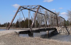
| March 2019 | Flood | Sargent | $1,000,000 | Historical bridge 1 mile south of Sargent destroyed by Ice flows along the Middle Loup River. |
| October 2000 | Tornado (F2) | Broken Bow | $1,000,000 | The tornado touched down 7 miles southeast of Broken Bow and traveled 12 miles north northeast across farm and rangeland. Initial damage occurred at touchdown with a modular home destroyed. Then over the next 2 miles 3 farmsteads were struck. The first suffered heavy damage to all buildings including the house. At the second farmstead a modular home and several buildings were completely destroyed. The third farmstead suffered extensive damage to the outbuildings and minor damage to the house. The tornado then moved across highway 2 and destroyed several farm building 4 miles east of Broken Bow. Then as the tornado moved across highway 70 another farmstead was struck with several outbuildings destroyed and the house damaged. The tornado remained on the the ground and destroyed a barn 5 miles northeast of Broken Bow, then did extensive damage to a farmstead 7 miles northeast of Broken Bow where several outbuildings were destroyed or damaged and damaged the house. Tree damage was extensive along the entire path and several center pivot irrigation systems were destroyed. The tornado lifted 7 miles northeast of Broken Bow. |
| October 2023 | Flash Flood | Broken Bow | $500,000 | Public reports flooding with buildings inundated at the Custer County Fairgrounds. |
| March 2019 | Flood | Anselmo | $500,000 | Custer county EM reports widespread flooding in Anselmo. |
| March 2019 | Flood | Sargent | $500,000 | Custer county emergency management reports extensive flooding in Sargent. |
| March 2019 | Flood | Callaway | $500,000 | Water reported over the road on Highway 40 from the junction of highway's 40 and 47 south of Arnold, to Arnold. Ditches are full with several secondary roads washed out in the Callaway area. |
| March 2019 | Flood | Oconto | $500,000 | Bridge abutment crossing the South Loup River on Highway 21 northeast of Oconto destroyed. |
| June 2010 | Flood | Merna | $300,000 | Thunderstorms with prolonged heavy rain falling on already saturated ground caused widespread flooding through northern and central Custer County. Three to five inches of rain caused water to flow across the Victoria Springs Road, the Callaway Road, and Highway 92 near Merna. The rain produced a sink hole, 4 feet in depth, to form in the road between Merna and Victoria Springs. The south side of the Sargent Diversion Dam collapsed sending a tremendous amount of water to the Comstock Diversion Dam which held the water. Numerous rural roads were also severely damaged. |
| June 1999 | Tornado (F2) | Comstock | $300,000 | no account filed |
| June 2022 | Hail | Callaway | $250,000 | Hail broke numerous windshields and windows in homes in Callaway. Siding on homes sustained damage as well. |
| June 2008 | Hail | Westerville | $250,000 | Hail sizes ranging from quarter to grapefruit size broke many windows, tore holes in the siding of homes, broke windshields in numerous vehicles, and severely damaged the vehicle bodies. |
| May 2007 | Flash Flood | Arnold | $250,000 | Thunderstorms produced very heavy rainfall of 2 to 6 inches across southern Custer County. Water going over Highway 92 between Arnold and Merna washed out the shoulders in several locations. Small mudslides onto the railroad tracks occurred at the Ansley overpass. Highway 21 south of Broken Bow was also under water. Numerous secondary roads were severely damaged due to water over the roads. |
| October 2000 | Tornado (F1) | Sargent | $250,000 | The tornado touched down 2 miles west of Sargent with damage to a farm building and center pivot irrigation system. The tornado moved north northeast with several power poles broken off and minor damage produced at a farm 2 miles northwest of Sargent. The tornado then moved across open country until destroying a communication tower and several power poles 5 miles north of Sargent. A farm building was then damaged 6 miles north of Sargent before the tornado moved into southeast Loup county. |
| June 1990 | Tornado (F3) | not stated | $250,000 | no account filed |
| April 1986 | Tornado (F2) | not stated | $250,000 | no account filed |
| June 1975 | Tornado (F3) | not stated | $250,000 | no account filed |
| April 1973 | Tornado (F1) | not stated | $250,000 | no account filed |
| May 1961 | Tornado (F4) | not stated | $250,000 | no account filed |
| July 1955 | Tornado (F2) | not stated | $250,000 | no account filed |
| June 1953 | Tornado (F2) | not stated | $250,000 | no account filed |
| May 1999 | Thunderstorm Wind | Arnold | $220,000 | no account filed |
| March 2019 | Flood | Oconto | $200,000 | Street flooding reported in Oconto. |
| June 2013 | Thunderstorm Wind | Broken Bow | $200,000 | Strong winds downed power lines and produced extensive tree damage in Broken Bow. Additional damage included overturned center pivots east of town and in Callaway. Visible wind damage covered a 40 mile path from Callaway to Comstock. |
| June 2012 | Thunderstorm Wind | Broken Bow | $150,000 | Downburst winds up to 70 mph caused extensive tree damage and loss of power to half the city of Broken Bow. Reports of wind damage extended through west central Custer County to include Callaway and Arnold, where fallen tree limbs caused damage to homes, parks and power lines. |
| May 2007 | Tornado (EF1) | Callaway | $150,000 | The tornado touched down 17 miles southwest of Callaway and tracked northward for approximately 21 miles near Highways 47 and 40 in western Custer County before lifting approximately 5 miles east of Arnold. The tornado destroyed several grain bins, uprooted trees, destroyed a garage and small outbuildings, overturned center pivot irrigation systems, snapped many power poles, broke windows, destroyed a barn, and mangled farm machinery, vehicles, and a horse trailer. |
| May 2004 | Hail | Oconto | $150,000 | Hail completely shredded wheat fields and newly planted corn northwest of Oconto. Roofs and siding on nearly every home and business were severely damaged. Vehicles sustained severe body damage along with broken windows. |
| April 2007 | Tornado (EF1) | Oconto | $125,000 | This tornado formed southwest of Gothenburg in Dawson County (see Storm Data for Nebraska, South Central for more information on the beginning portion of this tornado) and tracked north before entering Custer County about 21 miles west southwest of Oconto at 9:35 PM CST. The tornado continued for another 7 miles before dissipating 17 miles southwest of Callaway at 9:40 PM CST. In Custer County, the tornado destroyed a barn, chicken house, milk house, an oil bin, and two dryer bins. In addition, it overturned center pivot irrigation systems, snapped and uprooted trees, and broke off power poles. While in Dawson County, the tornado was rated an F2 but was rated an F1 in Custer County. |
| March 2019 | Flood | Comstock | $100,000 | Bridge approaches on highway 21C crossing the Middle Loup River just west of Comstock have been compromised. |
| June 2013 | Thunderstorm Wind | Broken Bow | $100,000 | Strong winds downed large trees and power lines. Roofs were blown off buildings with one roof estimated 30 to 40 yards away from a house. |
| July 2012 | Thunderstorm Wind | Callaway | $100,000 | Strong straight line thunderstorm winds overturned center pivot irrigation systems and uprooted large trees southwest of Callaway. |
| April 2001 | Tornado (F1) | Berwyn | $100,000 | An F1 tornado developed just west of Berwyn in southeast Custer County. In the minute and a half that it was on the ground, it picked up a van on Highway 2, turned it around, and shattered the windows. The occupants of the van were uninjured. Numerous trees were uprooted or snapped off, and the roof was torn off a farm house. Another farmstead suffered damage to the house and barn. There were also irrigation pipes tossed around and bent. |
| July 2000 | Hail | Oconto | $100,000 | no account filed |
| June 1999 | Thunderstorm Wind | Comstock | $100,000 | no account filed |
| June 2024 | Tornado (EF2) | Arnold | $80,000 | Tornado touched down in the vicinity of Eureka Valley road and 15 road and traveled to the southeast for approximately 2 miles. Where the initial touchdown occurred, numerous power poles were snapped and a twisted a center pivot irrigation system occurred. Several large pieces of aluminum irrigation pipe were lofted and deposited. The tornado tracked east southeast, uprooting and damaging large trees near Dry Creek and Road 420. |
| June 2017 | Thunderstorm Wind | Arnold | $80,000 | Pivot overturned, numerous trees down, and a 100 x 80 foot building partially destroyed. |
| September 2010 | Flash Flood | Sargent | $75,000 | Heavy rainfall led to the failure of a 50 foot dam near 3 miles southwest of Broken Bow on highway 21. The flood water moved down toward the southwest edge of town to impact the Callaway road one mile west of town and highway 21 as water flowed across the roads. Rainfall gage estimates around town measured up to 4.5 inches with several streets and homes in town flooded as well due to heavy rain. |
| June 2009 | Flash Flood | Arnold | $75,000 | Emergency Management reported numerous roads washed out from heavy rain. Road lengths of up to 150 feet were washed out. |
| June 2006 | Tornado (F1) | Arnold | $70,000 | A tornado from a supercell thunderstorm touched down briefly overturning two center pivot irrigation systems and destroying alfalfa and wheat fields. |
| June 1997 | Hail | Anselmo | $70,000 | Large hail and thunderstorm winds damaged young growing corn and blew over center pivot irrigation systems. |
| June 2024 | Flash Flood | Anselmo | $50,000 | Emergency management reports flooding in Anselmo. |
| May 2023 | Lightning | Merna | $50,000 | Lightning struck a house, setting it on fire. |
| March 2019 | Flood | Westerville | $50,000 | Highway 70 east of Westerville to the Custer and Sherman county line was closed due to flooding. |
| August 2017 | Thunderstorm Wind | Mason City | $50,000 | A full center pivot irrigation system was flipped over south of Ansley. Time estimated from radar. |
| June 2006 | Thunderstorm Wind | Arnold | $50,000 | A supercell thunderstorm that had produced a tornado 1 mile northwest of Arnold collapsed with strong outflow winds breaking off numerous large trees, snapping off power poles, and producing roof damage on some homes. |
| May 2004 | Tornado (F1) | Oconto | $50,000 | The tornado overturned a center pivot irrigation system and ripped a 90 foot section of roof off a hog confinement building. It also broke large limbs off trees. |
| June 2003 | Tornado (F0) | Arnold | $50,000 | A long lived supercell that moved from south central Lincoln County to northeast Lincoln County produced a tornado in Lincoln County near the Lincoln and Custer County line which then moved into Custer County. After entering Custer County, storm chasers and ranchers watched the tornado as it moved through corn fields and destroyed 2 center pivot irrigation systems. |
| July 2009 | Hail | Oconto | $50,000 | no account filed |
| July 2000 | Hail | Berwyn | $50,000 | no account filed |
| August 1996 | Thunderstorm Wind | Broken Bow | $50,000 | no account filed |
| May 2013 | Flash Flood | Berwyn | $40,000 | Thunderstorms trained to produced 3 to 5 inches of heavy rainfall where emergency management reported flooding with water over some roads in Broken Bow, a bridge was washed out on the Callaway Road and flooding over the road 4 miles west of Broken Bow. |
 Block