
BlockBefore
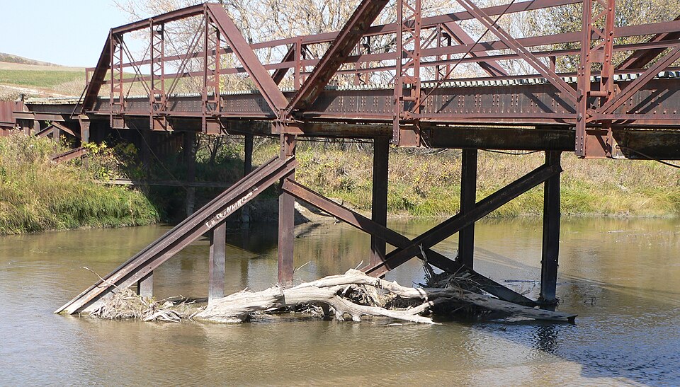
Photograph of Lewis Bridge
Photograph by Ammodramus, CC0 1.0. Via Wikimedia Commons.

Lewis Bridge

Listed on the National Register of Historic Places in 1992.

From the record

“The Lewis Bridge over the Keya Paha River is a historic bridge listed on the National Register of Historic Places in 1992.”

Wikipedia article Lewis Bridge (Keya Paha River), CC BY-SA 4.0.

One of 2 National Register listings published here for Keya Paha County · listed in 1992 · category: Structure.

Sources: the Wikipedia article · the case file at the National Archives · the National Register database, National Park Service

The listing

  • What is counted as historic. The nomination lists 1 structure as contributing to the listing.
  • Address. Co. Rd. over the Keya Paha R., 13.6 mi. NE of Springview, Springview, 68778
  • When was it listed? June 1992
  • Category. structure
  • Also known as. Highway Bridges in Nebraska MPS
  • Architect. Nebraska Department of Roads
  • National Register reference number. 92000774 - the number the National Park Service assigned this property when it was listed, and the key its nomination file is catalogued under at the National Archives.

Fires near this property

5 since 2000

Regional context, not property-specific evidence. The federal wildfire occurrence database lists 5 fires within 5 miles of Lewis Bridge between 2000 and 2020, burning about 74 acres in total. 1 started naturally. None was recorded as arson. Distance is straight-line from the map coordinates, so a fire counted here may appear on a neighbouring settlement's page as well.

Reported cause Fires
Equipment and vehicle use1
Recreation and ceremony1
Debris and open burning1
Natural1
Missing data/not specified/undetermined1

The most recent of them, most recent first, with the day each was reported and the service that recorded it.

DateCause SizeReported by Name on the report
15 July 2000Natural1.0 acresColome Volunteer Fire DepartmentCLIF PAULSON
21 November 2009Debris and open burning2.0 acresSouth Dakota Wildland Fire Suppressionnot named
15 October 2020Equipment and vehicle use1.0 acresNebraska Forest Servicenot named
13 October 2020Recreation and ceremony10 acresNebraska Forest Servicenot named
12 October 2014Missing data/not specified/undetermined60 acresSouth Dakota Wildland Fire SuppressionHAUPT

Every fire recorded in Keya Paha County

Storms near this property

60 of 130 shown

Regional context, not property-specific evidence. The National Weather Service names Springview, the town this property stands in, in 130 storm reports between 1996 and 2025: 105 hail, 22 thunderstorm wind, 1 flash flood, 1 tornado. The reports record 1 injury. Each account below is quoted exactly as the forecast office filed it, from the NOAA Storm Events Database, and each date opens the federal record of that event.

WhenEvent Place namedHarm What the report says
May 2007Tornado (EF1)Springview1 hurt, $100,000The cyclic supercell produced a tornado just as it entered southern Keya Paha County approximately 7 miles south southeast of Springview. The tornado tracked north northeastward for around 17 miles before lifting 5 miles north northeast of Burton. Along the path, the tornado took part of a roof off two homes, snapped trees, destroyed a barn and small outbuildings, overturned a center pivot irrigation system, and snapped 40 power poles. The tornado caused minor injuries to a gentleman that was on a farm tractor.
August 2021Thunderstorm WindSpringview$3,000,000Wind gust were estimated at 80 mph by public. Reports of several trees uprooted. A camper was rolled and a grain bin was damaged. Estimated a half mile of power poles snapped, power lost.
May 2007Flash FloodSpringview$120,000Heavy rains from thunderstorms caused flash flooding and washed out some bridges, roads, and culverts. Emergency management reported that 67 miles of roads were closed in the county.
June 1999Thunderstorm WindSpringview$100,000A storm system moved through Springview causing major damage to buildings, power poles and numerous trees. Surface wind estimates were 100 mph. The wind at the top of wind turbines west of Springview were measured at 136 mph about 200 feet above the surface.
August 2007Thunderstorm WindSpringview$80,000Thunderstorm wind gusts overturned 2 center pivots, damaged a wind mill and some small sheds and uprooted several trees.
March 2019FloodSpringview$50,000Heavy rainfall combined with snow melt and frost in the ground for ice jams that produced blocked roadways from large ice blocks and flood waters on Highway 7 in Keya Paha County along the Keya Paha and Niobrara rivers.
March 2009Thunderstorm WindSpringview$40,000The strong thunderstorm winds broke off large tree limbs, tore off the roof of a hay shed, overturned a center pivot irrigation system, damaged a grain bin, and overturned a corn crib.
June 2001HailSpringview$20,000no account filed
August 2007HailSpringview$15,000no account filed
August 2005Thunderstorm WindSpringview$10,000Thunderstorm outflow winds of 70 MPH moved two anchored sheds off of their foundations, broke large tree limbs and downed power lines.
August 2004Thunderstorm WindSpringview$10,000Thunderstorm outflow winds broke off large tree branches and snapped off power poles.
July 2000HailSpringview$10,000no account filed
July 2001HailSpringview$9,000no account filed
July 2001HailSpringview$8,000Small tree limbs down.
August 2003HailSpringview$5,000Hail poked holes in vinyl siding on homes.
May 2000Thunderstorm WindSpringview$5,000Wind damage to shop building
July 1998Thunderstorm WindSpringview$5,000Several large tree limbs blown down.
August 2006HailSpringview$5,000no account filed
June 2003HailSpringview$5,000no account filed
July 2001HailSpringview$5,000no account filed
June 1999HailSpringview$4,000no account filed
August 2002HailSpringview$3,000no account filed
August 1997HailSpringview$3,000no account filed
April 2007HailSpringview$2,000no account filed
July 2015Thunderstorm WindSpringview$1,000Thunderstorm wind gusts estimated at 60 MPH produced minor tree damage.
June 1999Thunderstorm WindSpringview$1,000At Sunny Brook Camp (20 miles west northwest of Springview) 10 to 12 inch tree branches were down and a canoe trailer was blown over.
May 2000Thunderstorm WindSpringview$500Large tree down
April 2025Thunderstorm WindSpringview-Thunderstorm wind gust of 62 MPH measured at this location.
July 2024HailSpringview-Nickel to quarter sized hail reported at this location.
May 2023HailSpringview-Penny sized hail reported at this location.
July 2020Thunderstorm WindSpringview-Several power lines were downed in Springview. A roof was also torn off a building.
May 2019HailSpringview-Heavy rainfall reported along with quarter sized hail.
July 2016Thunderstorm WindSpringview-Public estimated a 60 mph wind gust southeast of Springview.
August 2011Thunderstorm WindSpringview-Thunderstorm winds were estimated between 50 m.p.h. and 60 m.p.h.
June 2008HailSpringview-Hail completed covered the ground.
June 2008HailSpringview-Nickel to quarter size hail fell for ten minutes.
August 2007Thunderstorm WindSpringview-Thunderstorm winds broke off 4 to 6 inch diameter tree limbs.
August 2007HailSpringview-Winds around 60 mph also accompanied the hail.
August 2006Thunderstorm WindSpringview-Strong thunderstorm outflow winds broke off numerous 6 to 7 inch diameter tree limbs.
July 2005Thunderstorm WindSpringview-The supercell storm that evolved into a bow echo in Cherry and Brown counties also moved across Keya Paha County, uprooting and breaking off large trees. A hog shed was destroyed and several 1200 pound hay bales were moved from a field into a ditch. Several outbuildings also received major damage. The storm also moved across Rock, Boyd, and Holt counties.
July 2025HailSpringview-no account filed
July 2024HailSpringview-no account filed
June 2022HailSpringview-no account filed
June 2021HailSpringview-no account filed
August 2021HailSpringview-no account filed
August 2020HailSpringview-no account filed
September 2016HailSpringview-no account filed
July 2016HailSpringview-no account filed
July 2015HailSpringview-no account filed
September 2014HailSpringview-no account filed
May 2014HailSpringview-no account filed

Every storm recorded in Keya Paha County

Map coverage status

No historic map-sheet match is published for this property yet. That does not mean no map exists. This record needs a coordinate-quality review before it can be joined to a sheet boundary. Browse the county's mapped places while that work is pending.

Sources for this property

National Archives recordThe nomination case file for reference 92000774 in Record Group 79.
Wikipedia articleCommunity-written account of this property, licensed CC BY-SA.
Keya Paha CountyAll 2 listed properties in this county.

Provenance

  • Listing record. National Park Service National Register of Historic Places, listed-properties dataset, current to 2026-05-22.
  • Map join. Address geocoded through the United States Census geocoder, then tested against the published boundary of every sheet in the USGS Historical Topographic Map Collection.
  • How this page is made. Listing fields come from federal records; map-sheet coverage is a labelled coordinate-to-boundary calculation, not a source-field claim.
  • Wildfire. Short, Karen C. 2022. Spatial wildfire occurrence data for the United States, 1992-2020 [FPA_FOD_20221014]. 6th Edition. Fort Collins, CO: Forest Service Research Data Archive. https://doi.org/10.2737/RDS-2013-0009.6 Collected with United States Government funding and usable without additional permissions or fees.
  • Storms. NOAA National Centers for Environmental Information, Storm Events Database https://www.ncei.noaa.gov/stormevents/ A work of the United States government, no copyright under 17 U.S.C. 105. Narratives are quoted verbatim from the National Weather Service report and are not edited or summarised.